
August 2017: Looking Back at Harvey 5 Year Later
Hmm. Would the Euro mean less rain/wind for an area a bit inland such as Sugar Land, since it wouldn't be sitting there as long with us in the dirty side, or would it wind up being about equal or more due to a re-strengthened storm passing closer by (but more in the northwest quadrant)?
I want to take a moment to thank all the pro mets on this forum. I wasn't on this forum for Ike or I might have been more informed. Been following here for a long time now. It is where I come to find out the real scoop. Weatherman on another news channel said this afternoon what ya'll have been saying since early this morning.

Yeah, that's brutal. Harvey strengthens on its re-emergence around Lockport and then track parallel to the coast.davidiowx wrote:This is Tuesday.....ajurcat wrote:Please elaborate.stormlover wrote:Wow euro run bad

-
srainhoutx

- Site Admin

- Posts: 19616
- Joined: Tue Feb 02, 2010 2:32 pm
- Location: Maggie Valley, NC
- Contact:
2:00 PM Thursday Update from Jeff:
Harvey continues into rapid intensification…pressure down to 979mb and winds sustained to 85mph.
100pm forecast now brings strong cat 3 (125mph sustained) into the middle TX coast…cat 4 is possible.
This is a life threatening hurricane and rainfall situation.
Preparations to protect life and property MUST be rushed to completion.
Numerous evacuation orders are now in effect….follow orders immediately….persons in the hurricane warning area need to heed recommendations by local officials.
***Storm Surge warning extended to High Island…not including Galveston Bay***
New Evacuation Orders:
West end Galveston Island (voluntary evacuation order in place)
Mandatory Evac: City of Portland
Will get new impacts out after the 400pm NHC advisory package…biggest change at 100pm:
Raise storm surge values from Sargent to Jamaica Beach: 5-8 ft
Storm Surge Inundation link:
http://www.nhc.noaa.gov/refresh/graphic ... n#contents
Carla/Alicia/Jerry(In The Eye)/Michelle/Charley/Ivan/Dennis/Katrina/Rita/Wilma/Humberto/Ike/Harvey
Member: National Weather Association
Facebook.com/Weather Infinity
Twitter @WeatherInfinity
Member: National Weather Association
Facebook.com/Weather Infinity
Twitter @WeatherInfinity

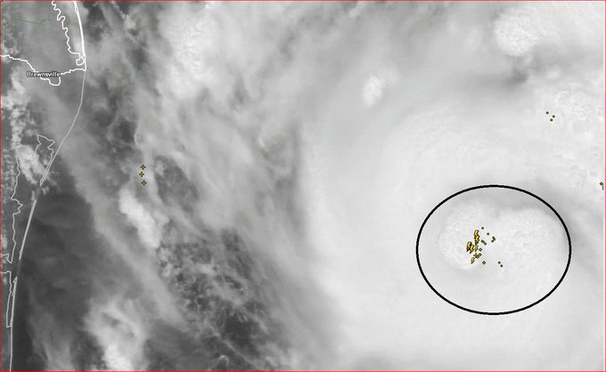
Lots of lightning being detected near the eyewall ..... sign of further strengthening to come? Harvey means business.
~~~When Thunder Roars Go Indoors~~~
~~~Turn Around Don't Drown~~~
~~~Run From The Water, Hide From The Wind~~~
~~~Turn Around Don't Drown~~~
~~~Run From The Water, Hide From The Wind~~~
-
srainhoutx
- Site Admin
- Posts: 19616
- Joined: Tue Feb 02, 2010 2:32 pm
- Location: Maggie Valley, NC
- Contact:
For our Neighbors down the Coast from Victoria to Corpus Christi...
Hurricane Harvey Local Statement Special Advisory Number 17
National Weather Service Corpus Christi TX AL092017
225 PM CDT Thu Aug 24 2017
This product covers SOUTH TEXAS
**Harvey Intensifies to a Category 1 Hurricane**
NEW INFORMATION
---------------
* CHANGES TO WATCHES AND WARNINGS:
- A Storm Surge Warning has been issued for Victoria
* CURRENT WATCHES AND WARNINGS:
- A Storm Surge Warning and Hurricane Warning are in effect for
Aransas, Calhoun, Kleberg, Nueces, Refugio, San Patricio, and
Victoria
- A Tropical Storm Warning is in effect for Duval and McMullen
- A Hurricane Warning is in effect for Bee, Goliad, Jim Wells,
and Live Oak
* STORM INFORMATION:
- About 320 miles southeast of Port Aransas TX or about 330 miles
south-southeast of Port Oconnor TX
- 24.4N 93.6W
- Storm Intensity 85 mph
- Movement North-northwest or 335 degrees at 10 mph
SITUATION OVERVIEW
------------------
Harvey is now a Category 1 hurricane across the west central Gulf
of Mexico. Harvey is expected to continue to strengthen as it moves
toward the Texas coast this afternoon through Friday. Harvey is
expected to reach Category 3 status prior to landfall. Tropical storm
force winds could approach coastal areas in the Coastal Bend as early
as early Friday morning.
Heavy rainfall is expected through much of the area with rainfall
totals of 15 to 20 inches east of Interstate 37 with isolated amounts
around 30 inches possible. Lesser amounts are expected further west
and southwest. These numbers and locations are subject to change
depending on the exact location of landfall along the Texas coast.
Flash flooding is possible with these high rainfall totals. The
heaviest rains are expected to occur Thursday night through Saturday
night and possibly into early next week.
Peak Storm surge inundation is generally expected to be 6 to 10 feet
above ground level from the north entrance of the Padre Island
National Seashore northward to Port O Connor. South of the North Padre
Island National Seashore is generally expected to be 5 to 7 feet above
ground level. Impacts would be felt along the barrier islands and into
the inland bays and waterways. Isolated locations could see slightly
higher inundation.
Tornadoes are possible as rainbands move onshore Thursday night
through Saturday, especially north and east of the center of Harvey.
POTENTIAL IMPACTS
-----------------
* WIND:
Protect against life-threatening wind having possible devastating
impacts across the Coastal Bend. Potential impacts in
this area include:
- Structural damage to sturdy buildings, some with complete roof
and wall failures. Complete destruction of mobile homes. Damage
greatly accentuated by large airborne projectiles. Locations
may be uninhabitable for weeks or months.
- Numerous large trees snapped or uprooted along with fences and
roadway signs blown over.
- Many roads impassable from large debris, and more within urban
or heavily wooded places. Many bridges, causeways, and access
routes impassable.
- Widespread power and communications outages.
Also, protect against life-threatening wind having possible
significant to extensive impacts across the Brush Country.
* SURGE:
Protect against life-threatening surge having possible devastating
impacts across the Middle Texas Coast and barrier islands. Potential
impacts in this area include:
- Widespread deep inundation, with storm surge flooding greatly
accentuated by powerful battering waves. Structural damage to
buildings, with many washing away. Damage greatly compounded
from considerable floating debris. Locations may be
uninhabitable for an extended period.
- Near-shore escape routes and secondary roads washed out or
severely flooded. Flood control systems and barriers may become
stressed.
- Extreme beach erosion. New shoreline cuts possible.
- Massive damage to marinas, docks, boardwalks, and piers. Numerous
small craft broken away from moorings with many lifted onshore
and stranded.
Elsewhere across SOUTH TEXAS, little to no impact is anticipated.
* FLOODING RAIN:
Protect against life-threatening rainfall flooding having possible
extensive impacts across the Coastal Bend, especially east of
Interstate 37. Potential impacts include:
- Major rainfall flooding may prompt many evacuations and rescues.
- Rivers and tributaries may rapidly overflow their banks in
multiple places. Small streams, creeks, canals, and ditches may
become dangerous rivers. Flood control systems and barriers may
become stressed.
- Flood waters can enter many structures within multiple
communities, some structures becoming uninhabitable or washed
away. Many places where flood waters may cover escape routes.
Streets and parking lots become rivers of moving water with
underpasses submerged. Driving conditions become dangerous.
Many road and bridge closures with some weakened or washed out.
Protect against dangerous rainfall flooding having possible limited
to significant impacts across the Brush Country.
* TORNADOES:
Protect against a tornado event having possible limited impacts across
South Texas. Potential impacts include:
- The occurrence of isolated tornadoes can hinder the execution
of emergency plans during tropical events.
- A few places may experience tornado damage, along with power
and communications disruptions.
- Locations could realize roofs peeled off buildings, chimneys
toppled, mobile homes pushed off foundations or overturned,
large tree tops and branches snapped off, shallow-rooted trees
knocked over, moving vehicles blown off roads, and small boats
pulled from moorings.
Elsewhere across SOUTH TEXAS, little to no impact is anticipated.
PRECAUTIONARY/PREPAREDNESS ACTIONS
----------------------------------
* EVACUATIONS:
For those under evacuation orders, leave as soon as practical with a
destination in mind. Gas up your vehicle well ahead of time. Be sure
that you take all essential materials from your emergency supplies kit.
Let others know where you are going and when you intend to arrive.
* OTHER PREPAREDNESS INFORMATION:
The following locations have issued a mandatory evacuation:
- The city of Port Aransas
- Aransas County
- Refugio County
- San Patricio County
CHRISTUS Spohn Health System to close certain locations:
- CLOSED: Robstown, Northside, Westside, Padre Island, Freer,
Beeville, Dr. Hector P. Garcia, and Memorial Quick Care (Reopen
Monday, August 28).
- CLOSED: CHRISTUS Physician Group physician practices.
- ABBREVIATED WORK SCHEDULE: Promptu Clinics will operate a shortened
schedule on Friday, August 25.
Now is the time to bring to completion all preparations to protect
life and property in accordance with your emergency plan.
Outside preparations should be wrapped up as soon as possible before
weather conditions completely deteriorate. Any remaining evacuations
and relocations should be expedited before the onset of tropical
storm force wind.
Closely monitor NOAA Weather radio or other local news outlets for
official storm information. Be ready to adapt to possible changes to
the forecast.
* ADDITIONAL SOURCES OF INFORMATION:
- For information on appropriate preparations see ready.gov
- For information on creating an emergency plan see getagameplan.org
- For additional disaster preparedness information see redcross.org
NEXT UPDATE
-----------
The next local statement will be issued by the National Weather
Service in Corpus Christi TX around 4 PM CDT, or sooner if conditions
warrant.
Carla/Alicia/Jerry(In The Eye)/Michelle/Charley/Ivan/Dennis/Katrina/Rita/Wilma/Humberto/Ike/Harvey
Member: National Weather Association
Facebook.com/Weather Infinity
Twitter @WeatherInfinity
Member: National Weather Association
Facebook.com/Weather Infinity
Twitter @WeatherInfinity
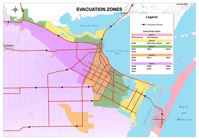
Corpus Christi Evacuation zones. Residents of Corpus are strongly encouraged to evacuate. If you have loved ones in these areas, please encourage them to leave if you haven't already. Especially if they are in the low lying areas of Zone A and B
~~~When Thunder Roars Go Indoors~~~
~~~Turn Around Don't Drown~~~
~~~Run From The Water, Hide From The Wind~~~
~~~Turn Around Don't Drown~~~
~~~Run From The Water, Hide From The Wind~~~
-
srainhoutx
- Site Admin
- Posts: 19616
- Joined: Tue Feb 02, 2010 2:32 pm
- Location: Maggie Valley, NC
- Contact:
Doing some house cleaning with information that was provided earlier in the day from the WPC regarding Harvey's Flood Potential...
EXTENDED FORECAST DISCUSSION
NWS WEATHER PREDICTION CENTER COLLEGE PARK MD
1156 AM EDT THU AUG 24 2017
VALID 12Z SUN AUG 27 2017 - 12Z THU AUG 31 2017
...EXTREMELY HEAVY, IF NOT HISTORICAL, TROPICAL RAINS IS EXPECTED
FOR TX AND LA...
15Z UPDATE
~~~~~~~~~~
THE MEAN UPPER-LEVEL PATTERN WILL BUDGE LITTLE OVER THE NEXT WEEK
WITH A RIDGE OUT WEST AND POSITIVE HEIGHT ANOMALIES EXTENDING FROM
OFF THE WEST COAST THROUGH A LARGE PORTION OF THE WEST INTO
CENTRAL CANADA. MEANWHILE, TWO NEG ANOMALIES, TROUGH OVER THE
NORTHEAST AND HARVEY NEAR SOUTH/SOUTHEAST TX AND WESTERN GULF OF
MEXICO, BECOME ONE AS A TROUGH AXIS ALIGNED FROM THE OH VALLEY TO
THE LOWER MS VALLEY/WESTERN GULF COAST.
ALL EYES THOUGH WILL BE ON HARVEY DURING THE MEDIUM RANGE PERIOD
AND WPC FOLLOWED THE OFFICIAL NHC FORECAST WITH THE TROPICAL
ENTITY THROUGH D5/TUES, A POSITION ALONG THE CENTRAL TX COAST.
AFTER TUES, THE OPERATIONAL GUIDANCE AND ENSEMBLE DATA SHOW
NARROWING SPREAD, AS HARVEY TRAPPED BETWEEN TWO STRONG UPPER
RIDGES FEELS THE INFLUENCE OF A MID TO UPPER TROUGH AND BEGINS TO
TRACK NNE TO NORTHEAST. THE QUESTION IS HOW MUCH INFLUENCE AND HOW
FAR NORTH DOES HARVEY GET. WPC GENERALLY FOLLOWED A BLEND OF THE
00Z GFS/ECMWF/EC MEAN/GEFS MEAN, WHICH DRAWS HARVEY UP TO COASTAL
SERN TX/SWRN LA AND THEN UP INTO EAST CENTRAL LA/WEST CENTRAL MS.
THIS IS THE GENERAL MOTION AND TRACK OF THE GUIDANCE OUT TO NEXT
THURS, THOUGH THE LATEST TREND WITH THE 06Z GFS IS TO WEAKEN
HARVEY AND WASH IS ALONG A CO-RELATED SYNOPTIC FRONT. THIS WILL
NEED TO BE MONITORED ALONG WITH ALL FACETS OF HARVEY AND THE
WESTERLIES.
FOR SENSIBLE WEATHER, THE WPC MEAN MAX TEMP ANOMALY SUGGEST BELOW
AVG HIGHS FROM MID-ATL/SOUTHEAST (FALL-LIKE WEATHER) TO LOWER MS
VALLEY AND TX (HARVEY). ABOVE AVG HIGHS WILL BE VERY LIKELY FROM
THE DESERT SW THROUGH MUCH OF THE WEST, EXCEPT PERHAPS ALONG THE
IMMEDIATE WEST COAST (MARINE LAYER).
THE PRECIPITATION BREAKDOWN LOOKS LIKE THIS, SUN/MON EXTENSIVE
RAINS ACROSS TX WITH HARVEY POSSIBLY EXTENDING INTO LA AND
SCATTERED SHOWERS/STORMS WITH FRONTAL ZONE FROM UPPER MS
VALLEY/WESTERN GREAT LAKES THROUGH OH VALLEY INTO MID MS VALLEY
AND CENTRAL PLAINS WITH SCATTERED SHOWERS/STORMS ACROSS THE FL
PENINSULA AND A BRUSH OF PRECIP ALONG THE SOUTHEAST COAST. THEN
TUES THROUGH THURS, VERY HEAVY RAINS CONTINUE FROM THE MAIN
CORRIDOR OF LA/SOUTHEAST TX UP THE MS RIVER TO THE SOUTHERN OH
RIVER VALLEY AND MORE SCATTERED SHOWERS STORMS WITH THE RETURNING
NORTH SYNOPTIC SCALE FRONT NORTH AND EAST OF HARVEY.
THE BOTTOM LINE IS EXTENSIVE HEAVY TROPICAL RAINFALL ACROSS THE
EASTERN PORTION OF TX INTO LA AND THIS MIGHT BE PUTTING IT MILDLY,
WITH UNFORTUNATELY EXTENSIVE FLOODING POSSIBLE. PLEASE STAY TUNED
TO THE LATEST UPDATES FROM THE NHC ON HARVEY AND RAINFALL INFO
FROM WPC.
MUSHER
Carla/Alicia/Jerry(In The Eye)/Michelle/Charley/Ivan/Dennis/Katrina/Rita/Wilma/Humberto/Ike/Harvey
Member: National Weather Association
Facebook.com/Weather Infinity
Twitter @WeatherInfinity
Member: National Weather Association
Facebook.com/Weather Infinity
Twitter @WeatherInfinity

My husband heard on the radio just now of mandatory evacuations for all coastal counties. Is this correct? I am in Brazoria county. We are totally hurricane (evacuation) prepared, but I haven't seen anything about Brazoria Co. and wondering if the radio station was exaggerating.
Please advise,
Thanx Yall for all you do!
Please advise,
Thanx Yall for all you do!
IMO, If you are packed and ready, I would leave, beat the rush. I'm sure at some point you will be in the mandatory zone so might as well head out now if you have a place to go....that's what I would do, FWIW....best of luck to you!kayci wrote:My husband heard on the radio just now of mandatory evacuations for all coastal counties. Is this correct? I am in Brazoria county. We are totally hurricane (evacuation) prepared, but I haven't seen anything about Brazoria Co. and wondering if the radio station was exaggerating.
Please advise,
Thanx Yall for all you do!
Everyone from Galveston to South Padre needs to be preparing Today for Harvey. Pay attention as djjordan and Srain indicated to any Evacuation orders... and ROUTES. IIRC the Rita evacuation was a Disaster.
I've lived in Texas from 25 years but am from North Carolina and have seen a few TCs. This one is serious business...and unfortunately steering currents are light once Harvey reaches shore. Prepare, expect the worst, and hope for the best.
https://dsx.weather.com/util/image/map/ ... 80x720.jpg

http://www.nhc.noaa.gov/storm_graphics/ ... toa_34.png
I've lived in Texas from 25 years but am from North Carolina and have seen a few TCs. This one is serious business...and unfortunately steering currents are light once Harvey reaches shore. Prepare, expect the worst, and hope for the best.
https://dsx.weather.com/util/image/map/ ... 80x720.jpg
http://www.nhc.noaa.gov/storm_graphics/ ... toa_34.png
Last edited by DoctorMu on Thu Aug 24, 2017 3:10 pm, edited 3 times in total.
Kayci, These are the only evacuation orders I have come across for Brazoria County as of now.
Brazoria County - Mandatory evacuation order issued for coastal communities along the Gulf side of the Intercoastal Waterway
Brazoria County - Voluntary evacuation order issued for low-lying coastal areas inland of Intercoastal Waterway.
Brazoria County - Mandatory evacuation order issued for coastal communities along the Gulf side of the Intercoastal Waterway
Brazoria County - Voluntary evacuation order issued for low-lying coastal areas inland of Intercoastal Waterway.
~~~When Thunder Roars Go Indoors~~~
~~~Turn Around Don't Drown~~~
~~~Run From The Water, Hide From The Wind~~~
~~~Turn Around Don't Drown~~~
~~~Run From The Water, Hide From The Wind~~~

I read somewhere Galveston has issued voluntary evacuations down there on some parts of the island. In particular the Bolivar area.
davidiowx wrote:I read somewhere Galveston has issued voluntary evacuations down there on some parts of the island. In particular the Bolivar area.
Really good idea.
TxDot opening evacuation lane on I-37 from Corpus to San Antonio.
-
houstonia
- Posts: 138
- Joined: Sun Jun 14, 2015 6:51 pm
- Location: Houston, Texas (Southwest side; Sharpstown)
- Contact:
The latest on EVACS from HCFCD met:snowman65 wrote:IMO, If you are packed and ready, I would leave, beat the rush. I'm sure at some point you will be in the mandatory zone so might as well head out now if you have a place to go....that's what I would do, FWIW....best of luck to you!kayci wrote:My husband heard on the radio just now of mandatory evacuations for all coastal counties. Is this correct? I am in Brazoria county. We are totally hurricane (evacuation) prepared, but I haven't seen anything about Brazoria Co. and wondering if the radio station was exaggerating.
Please advise,
Thanx Yall for all you do!
Mandatory Evacuation: Brazoria County (Gulf of Mexico to the Intracoastal Canal)
Mandatory Evacuation: all Calhoun County (effective immediately)
Mandatory Evacuation: Matagorda County (South of FM 521 and FM 2611 in Sargent), all areas S of FM 521 in Matagorda County, all areas south of Business 35 W of Palacios. All persons under age of 18 must leave the evacuation area
Port Aransas/Aransas Pass: Mandatory evacuation (effective immediately)
Mandatory Evacuation: all San Patricio County (effective at noon today)
Mandatory Evacuation: City of Ingleside (effective immediately)
Mandatory Evacuation: All Refugio County (effective immediately)
Like
CommentShare
Thank you DJ, I think we will head to our friend in Fredericksburgdjjordan wrote:Kayci, These are the only evacuation orders I have come across for Brazoria County as of now.
Brazoria County - Mandatory evacuation order issued for coastal communities along the Gulf side of the Intercoastal Waterway
Brazoria County - Voluntary evacuation order issued for low-lying coastal areas inland of Intercoastal Waterway.
Can really see the development of the eye on GOES-16 Visible over the last few hours.
-
srainhoutx
- Site Admin
- Posts: 19616
- Joined: Tue Feb 02, 2010 2:32 pm
- Location: Maggie Valley, NC
- Contact:
BULLETIN
Hurricane Harvey Advisory Number 18
NWS National Hurricane Center Miami FL AL092017
400 PM CDT Thu Aug 24 2017
...HARVEY HEADED TOWARD THE TEXAS COAST...
...LIFE-THREATENING AND DEVASTATING FLOODING EXPECTED NEAR THE
COAST DUE TO HEAVY RAINFALL AND STORM SURGE...
SUMMARY OF 400 PM CDT...2100 UTC...INFORMATION
----------------------------------------------
LOCATION...24.7N 93.9W
ABOUT 305 MI...490 KM SE OF CORPUS CHRISTI TEXAS
ABOUT 300 MI...480 KM SSE OF PORT OCONNOR TEXAS
MAXIMUM SUSTAINED WINDS...85 MPH...140 KM/H
PRESENT MOVEMENT...NNW OR 330 DEGREES AT 10 MPH...17 KM/H
MINIMUM CENTRAL PRESSURE...976 MB...28.82 INCHES
WATCHES AND WARNINGS
--------------------
CHANGES WITH THIS ADVISORY:
The Hurricane Warning has been extended northeast of Matagorda to
Sargent Texas.
SUMMARY OF WATCHES AND WARNINGS IN EFFECT:
A Storm Surge Warning is in effect for...
* Port Mansfield to High Island Texas
A Storm Surge Watch is in effect for...
* South of Port Mansfield Texas to the Mouth of the Rio Grande
A Hurricane Warning is in effect for...
* Port Mansfield to Sargent Texas
A Tropical Storm Warning is in effect for...
* North of Sargent to High Island Texas
* South of Port Mansfield Texas to the Mouth of the Rio Grande
A Hurricane Watch is in effect for...
* South of Port Mansfield Texas to the Mouth of the Rio Grande
A Tropical Storm Watch is in effect for...
* South of the Mouth of the Rio Grande to Boca de Catan Mexico
A Storm Surge Warning means there is a danger of life-threatening
inundation, from rising water moving inland from the coastline,
during the next 36 hours in the indicated locations. For a
depiction of areas at risk, please see the National Weather
Service Storm Surge Watch/Warning Graphic, available at
hurricanes.gov. This is a life-threatening situation. Persons
located within these areas should take all necessary actions to
protect life and property from rising water and the potential for
other dangerous conditions. Promptly follow evacuation and other
instructions from local officials.
A Hurricane Warning means that hurricane conditions are expected
somewhere within the warning area. A warning is typically issued
36 hours before the anticipated first occurrence of tropical-storm-
force winds, conditions that make outside preparations difficult or
dangerous. Preparations to protect life and property should be
rushed to completion.
A Storm Surge Watch means there is a possibility of life-
threatening inundation, from rising water moving inland from the
coastline, in the indicated locations during the next 48 hours.
A Hurricane Watch means that hurricane conditions are possible
within the watch area.
In addition, interests in southwestern Louisiana should continue to
monitor the progress of this system.
For storm information specific to your area in the United States,
including possible inland watches and warnings, please monitor
products issued by your local National Weather Service forecast
office. For storm information specific to your area outside the
United States, please monitor products issued by your national
meteorological service.
DISCUSSION AND 48-HOUR OUTLOOK
------------------------------
At 400 PM CDT (2100 UTC), the eye of Hurricane Harvey was located
near latitude 24.7 North, longitude 93.9 West. Harvey is moving
toward the north-northwest near 10 mph (17 km/h). A turn toward the
northwest is expected this evening, and Harvey's forward speed is
forecast to slow down during the next couple of days. On the
forecast track, Harvey will approach the middle Texas coast on
Friday and make landfall Friday night or early Saturday. Harvey is
then likely to stall near or just inland of the middle Texas coast
through the weekend.
Maximum sustained winds are near 85 mph (140 km/h) with higher
gusts. Strengthening is forecast, and Harvey is expected to become
a major hurricane by Friday before it reaches the middle Texas
coast.
Hurricane-force winds extend outward up to 25 miles (35 km) from the
center, and tropical-storm-force winds extend outward up to 90 miles
(150 km).
The minimum central pressure based on dropsonde data released by a
NOAA Hurricane Hunter aircraft is 976 mb (28.82 inches).
HAZARDS AFFECTING LAND
----------------------
RAINFALL: Harvey is expected to produce total rain accumulations
of 15 to 25 inches and isolated maximum amounts of 35 inches over
the middle and upper Texas coast through next Wednesday. During the
same time period Harvey is expected to produce total rain
accumulations of 7 to 15 inches in far south Texas and the Texas
Hill Country over through central and southwest Louisiana, with
accumulations of up to 7 inches extending into other parts of Texas
and the lower Mississippi Valley. Rainfall from Harvey may cause
devastating and life-threatening flooding.
STORM SURGE: The combination of a dangerous storm surge and the
tide will cause normally dry areas near the coast to be flooded by
rising waters moving inland from the shoreline. The water is
expected to reach the following heights above ground if the peak
surge occurs at the time of high tide...
N Entrance Padre Island Natl Seashore to Sargent...6 to 12 ft
Sargent to Jamaica Beach...5 to 8 ft
Port Mansfield to N Entrance Padre Island Natl Seashore...5 to 7 ft
Jamaica Beach to High Island...2 to 4 ft
Mouth of the Rio Grande to Port Mansfield...2 to 4 ft
High Island to Morgan City...1 to 3 ft
The deepest water will occur along the immediate coast near and to
the northeast of the landfall location, where the surge will be
accompanied by large and destructive waves. Surge-related flooding
depends on the relative timing of the surge and the tidal cycle, and
can vary greatly over short distances. For information specific to
your area, please see products issued by your local National Weather
Service forecast office.
WIND: Hurricane conditions are likely within the hurricane warning
area late Friday or Friday night, with tropical storm conditions
expected to first reach the coast in the hurricane warning area
Friday.
SURF: Swells generated by Harvey are likely to affect the Texas,
Louisiana, and northeast Mexico coasts by Friday. These swells are
likely to cause life-threatening surf and rip current conditions.
Please consult products from your local weather office.
NEXT ADVISORY
-------------
Next intermediate advisory at 700 PM CDT.
Next complete advisory at 1000 PM CDT.
$$
Forecaster Berg
Carla/Alicia/Jerry(In The Eye)/Michelle/Charley/Ivan/Dennis/Katrina/Rita/Wilma/Humberto/Ike/Harvey
Member: National Weather Association
Facebook.com/Weather Infinity
Twitter @WeatherInfinity
Member: National Weather Association
Facebook.com/Weather Infinity
Twitter @WeatherInfinity