
SEPTEMBER 2018 - Very Wet Month Wrap Up
-
Andrew
- Site Admin

- Posts: 3440
- Joined: Wed Feb 03, 2010 9:46 pm
- Location: North-West Houston
- Contact:
ECMWF is showing the best development right near landfall. Makes sense as other models have also been indicating that anticyclonic upper level flow could develop over the western gulf late this week. Slower it moves better chance for development.
For Your Infinite Source For All Things Weather Visit Our Facebook
-
stormlover
- Posts: 439
- Joined: Wed Dec 04, 2013 10:21 am
- Location: Lumberton TX
- Contact:
http://mp1.met.psu.edu/~fxg1/SAT_ATL/atlanim8vis.html
looks like its getting better organized but who knows
looks like its getting better organized but who knows
-
srainhoutx

- Site Admin
- Posts: 19616
- Joined: Tue Feb 02, 2010 2:32 pm
- Location: Maggie Valley, NC
- Contact:
Still looking like a sheared lop sided system where the worst of the weather will be NE and E of whatever development happens prior to landfall. Someone across portions of SE Texas into SW Louisiana could see an awfully lot of rainfall.
Carla/Alicia/Jerry(In The Eye)/Michelle/Charley/Ivan/Dennis/Katrina/Rita/Wilma/Humberto/Ike/Harvey
Member: National Weather Association
Facebook.com/Weather Infinity
Twitter @WeatherInfinity
Member: National Weather Association
Facebook.com/Weather Infinity
Twitter @WeatherInfinity
-
Andrew
- Site Admin
- Posts: 3440
- Joined: Wed Feb 03, 2010 9:46 pm
- Location: North-West Houston
- Contact:
stormlover wrote:http://mp1.met.psu.edu/~fxg1/SAT_ATL/atlanim8vis.html
looks like its getting better organized but who knows
A lot of that convection is from the TUTT. Heavily sheared as the vorticity is still well to the west and south of the convection. Going to stay that way until the TUTT moves out of the way and shears out some.
For Your Infinite Source For All Things Weather Visit Our Facebook
http://hurricanecity.com/models/models. ... stinvest=1
the "Storm Page" for Invest 95L from Tropical Atlantic.com, mirrored by HurricaneCity to reduce strain on server
links to storm-specific satellite, models & much more
the "Storm Page" for Invest 95L from Tropical Atlantic.com, mirrored by HurricaneCity to reduce strain on server
links to storm-specific satellite, models & much more
-
srainhoutx
- Site Admin
- Posts: 19616
- Joined: Tue Feb 02, 2010 2:32 pm
- Location: Maggie Valley, NC
- Contact:
And for those wondering, the last time there were 4 Hurricanes in the Atlantic Basin at one time was 1893.
Carla/Alicia/Jerry(In The Eye)/Michelle/Charley/Ivan/Dennis/Katrina/Rita/Wilma/Humberto/Ike/Harvey
Member: National Weather Association
Facebook.com/Weather Infinity
Twitter @WeatherInfinity
Member: National Weather Association
Facebook.com/Weather Infinity
Twitter @WeatherInfinity
This GFS loop shows Florence bouncing off the tip of N.C/Va. then moving back out to sea, then going back for a second landfall, hanging around for awhile inland, then heading back out to see again.....Very "Harvey" like...IDK
https://www.tropicaltidbits.com/analysi ... 1012&fh=96
https://www.tropicaltidbits.com/analysi ... 1012&fh=96

srainhoutx wrote:And for those wondering, the last time there were 4 Hurricanes in the Atlantic Basin at one time was 1893.
ZCZC MIATWOAT ALL
TTAA00 KNHC DDHHMM
Tropical Weather Outlook
NWS National Hurricane Center Miami FL
200 PM EDT Mon Sep 10 2018
For the North Atlantic...Caribbean Sea and the Gulf of Mexico:
The National Hurricane Center is issuing advisories on Hurricane
Florence, located over the west-central Atlantic Ocean, on
Hurricane Helene, located over the eastern Atlantic, and on
Hurricane Isaac, located over the central tropical Atlantic.
1. Showers and thunderstorms over the northwestern Caribbean Sea and
western Cuba, associated with a surface trough, are showing some
signs of organization. This system is forecast to move slowly
northwestward near the Yucatan Peninsula on Tuesday with limited
development. Upper-level winds are forecast to become more
conducive for development on Wednesday when the system moves over
the southern Gulf of Mexico, and a tropical depression could form
on Thursday or Friday while the disturbance moves across the
western Gulf of Mexico. Interests across northeastern Mexico and
the coast of Texas and Louisiana should monitor the progress of
this system. Regardless of development, heavy rainfall and gusty
winds are likely over western Cuba through Tuesday.
* Formation chance through 48 hours...low...30 percent.
* Formation chance through 5 days...medium...50 percent.
https://www.nhc.noaa.gov/gtwo.php

Meanwhile, back home, most of the heaviest rain is well off to the Northeast now. Most of the stuff around here and along the coast is just light stratiform rain.
I also see some rotation on the radar SE of San Antonio. Maybe that will gel into something overnight as it moves ENE...
I also see some rotation on the radar SE of San Antonio. Maybe that will gel into something overnight as it moves ENE...
-
srainhoutx
- Site Admin
- Posts: 19616
- Joined: Tue Feb 02, 2010 2:32 pm
- Location: Maggie Valley, NC
- Contact:
The afternoon just Updated surface charts for Days 3 through 5 have a low pressure system approaching the Lower/Middle Texas Coast Friday night/Saturday morning somewhere from Baffin Bay to Port Aransas.
- Attachments
-
-
-
Carla/Alicia/Jerry(In The Eye)/Michelle/Charley/Ivan/Dennis/Katrina/Rita/Wilma/Humberto/Ike/Harvey
Member: National Weather Association
Facebook.com/Weather Infinity
Twitter @WeatherInfinity
Member: National Weather Association
Facebook.com/Weather Infinity
Twitter @WeatherInfinity
-
srainhoutx
- Site Admin
- Posts: 19616
- Joined: Tue Feb 02, 2010 2:32 pm
- Location: Maggie Valley, NC
- Contact:
Flash Flood Watch that was due to drop at 7 AM tomorrow morning has been extended until at least Noon tomorrow. Favorable jet streak across New Mexico and West/North Texas and a favorable atmospheric wind pattern suggests redevelopment of storms overnight into tomorrow morning. The $64,000 question is the greatest threat along the Coast or further inland along the I-10 Corridor? Time will tell as the meso models are struggling with this pattern.
Carla/Alicia/Jerry(In The Eye)/Michelle/Charley/Ivan/Dennis/Katrina/Rita/Wilma/Humberto/Ike/Harvey
Member: National Weather Association
Facebook.com/Weather Infinity
Twitter @WeatherInfinity
Member: National Weather Association
Facebook.com/Weather Infinity
Twitter @WeatherInfinity
It's a reach but the 18z gfs is ever so slightly a little more defined. Nothing really organized but could finally be trending that way.
The disturbance gets a mention in the Flo disco with the idea that ridging to the N may not be as strong.
The disturbance gets a mention in the Flo disco with the idea that ridging to the N may not be as strong.
1998: Georges, Ivan, Karl, Jeanne https://weather.com/storms/hurricane/ne ... n-20130925BlueJay wrote:srainhoutx wrote:And for those wondering, the last time there were 4 Hurricanes in the Atlantic Basin at one time was 1893.WOW! We are living through some very historic days lately...
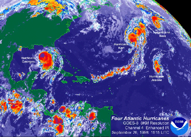

unome wrote:1998: Georges, Ivan, Karl, Jeanne https://weather.com/storms/hurricane/ne ... n-20130925BlueJay wrote:srainhoutx wrote:And for those wondering, the last time there were 4 Hurricanes in the Atlantic Basin at one time was 1893.
Ivan lasted 23 days and struck the US twice!
-
srainhoutx
- Site Admin
- Posts: 19616
- Joined: Tue Feb 02, 2010 2:32 pm
- Location: Maggie Valley, NC
- Contact:
TROPICAL WEATHER OUTLOOK
NWS NATIONAL HURRICANE CENTER MIAMI FL
800 PM EDT MON SEP 10 2018
FOR THE NORTH ATLANTIC...CARIBBEAN SEA AND THE GULF OF MEXICO:
THE NATIONAL HURRICANE CENTER IS ISSUING ADVISORIES ON HURRICANE
FLORENCE, LOCATED OVER THE WEST-CENTRAL ATLANTIC OCEAN, ON
HURRICANE HELENE, LOCATED OVER THE EASTERN ATLANTIC, AND ON
HURRICANE ISAAC, LOCATED OVER THE CENTRAL TROPICAL ATLANTIC.
SHOWERS AND THUNDERSTORMS OVER THE NORTHWESTERN CARIBBEAN SEA,
WESTERN CUBA, AND THE YUCATAN PENINSULA OF MEXICO ARE ASSOCIATED
WITH A SURFACE TROUGH AND ARE SHOWING SOME SIGNS OF ORGANIZATION.
THIS SYSTEM IS FORECAST TO MOVE SLOWLY NORTHWESTWARD ACROSS THE
YUCATAN PENINSULA ON TUESDAY WITH LIMITED DEVELOPMENT. UPPER-LEVEL
WINDS ARE FORECAST TO BECOME MORE CONDUCIVE FOR DEVELOPMENT LATER IN
THE WEEK, AND A TROPICAL DEPRESSION COULD FORM ON THURSDAY OR FRIDAY
WHILE THE DISTURBANCE MOVES ACROSS THE WESTERN GULF OF MEXICO.
INTERESTS ACROSS NORTHEASTERN MEXICO AND THE COAST OF TEXAS AND
LOUISIANA SHOULD MONITOR THE PROGRESS OF THIS SYSTEM. REGARDLESS OF
DEVELOPMENT, HEAVY RAINFALL AND GUSTY WINDS ARE LIKELY OVER WESTERN
CUBA AND THE YUCATAN PENINSULA THROUGH TUESDAY.
* FORMATION CHANCE THROUGH 48 HOURS...LOW...30 PERCENT.
* FORMATION CHANCE THROUGH 5 DAYS...MEDIUM...60 PERCENT.
- Attachments
-
Carla/Alicia/Jerry(In The Eye)/Michelle/Charley/Ivan/Dennis/Katrina/Rita/Wilma/Humberto/Ike/Harvey
Member: National Weather Association
Facebook.com/Weather Infinity
Twitter @WeatherInfinity
Member: National Weather Association
Facebook.com/Weather Infinity
Twitter @WeatherInfinity


It is from 1998. The other Ivan was in 2004.DoctorMu wrote:unome wrote:1998: Georges, Ivan, Karl, Jeanne https://weather.com/storms/hurricane/ne ... n-20130925BlueJay wrote:
Ivan lasted 23 days and struck the US twice!
-
srainhoutx
- Site Admin
- Posts: 19616
- Joined: Tue Feb 02, 2010 2:32 pm
- Location: Maggie Valley, NC
- Contact:
Shear still impacting and aiding in thunderstorm flare up. The latest GFS suggests wind shear may relax late Wednesday into Thursday. Our 'back yard' in notorious for quick spin ups with little model support and advance warning. That's why we always keep a weary eye on the Western Gulf during peak season when tropical troubles are lurking.
- Attachments
-
Carla/Alicia/Jerry(In The Eye)/Michelle/Charley/Ivan/Dennis/Katrina/Rita/Wilma/Humberto/Ike/Harvey
Member: National Weather Association
Facebook.com/Weather Infinity
Twitter @WeatherInfinity
Member: National Weather Association
Facebook.com/Weather Infinity
Twitter @WeatherInfinity
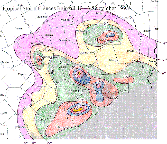
I remember 1998, it was the 1st time our home & neighborhood flooded from a tropical cyclone
Frances on 9/11 - I've had an obsession with weather ever since
https://www.wpc.ncep.noaa.gov/tropical/ ... s1998.html
Frances on 9/11 - I've had an obsession with weather ever since
https://www.wpc.ncep.noaa.gov/tropical/ ... s1998.html
-
- Information
-
Who is online
Users browsing this forum: Ahrefs [Bot], Bing [Bot], Semrush [Bot] and 64 guests