

Caught this tidbit in the NWS's overnight discussion:
The extended guidance has been indicating a weakness sliding across
the southern Gulf with radically different levels of organization
Sunday through Wednesday next week. Keep in mind that often the
extended guidance waffles around spurious solutions - is it
possible yes is it something to get worried about not yet - but
aware of yes.
SEPTEMBER 2018 - Very Wet Month Wrap Up
-
stormlover
- Posts: 439
- Joined: Wed Dec 04, 2013 10:21 am
- Location: Lumberton TX
- Contact:
Euro is on board, tropical storm north of corpus looks like a rita type track going through the straights could be interesting.
Yep, today's Euro run is more defined than previous runs. The NW Gulf has a history of storms intensifying near landfall on the Texas coast...Claudette, Humberto, and Harvey come to mind.
-
srainhoutx

- Site Admin

- Posts: 19616
- Joined: Tue Feb 02, 2010 2:32 pm
- Location: Maggie Valley, NC
- Contact:
Take it with a grain of salt at this time, but being near the climatological peak of Hurricane Season we will continue to monitor.stormlover wrote:Euro is on board, tropical storm north of corpus looks like a rita type track going through the straights could be interesting.
- Attachments
-
Carla/Alicia/Jerry(In The Eye)/Michelle/Charley/Ivan/Dennis/Katrina/Rita/Wilma/Humberto/Ike/Harvey
Member: National Weather Association
Facebook.com/Weather Infinity
Twitter @WeatherInfinity
Member: National Weather Association
Facebook.com/Weather Infinity
Twitter @WeatherInfinity


Hurricane Lane is one of the wettest tropical cyclone in America.
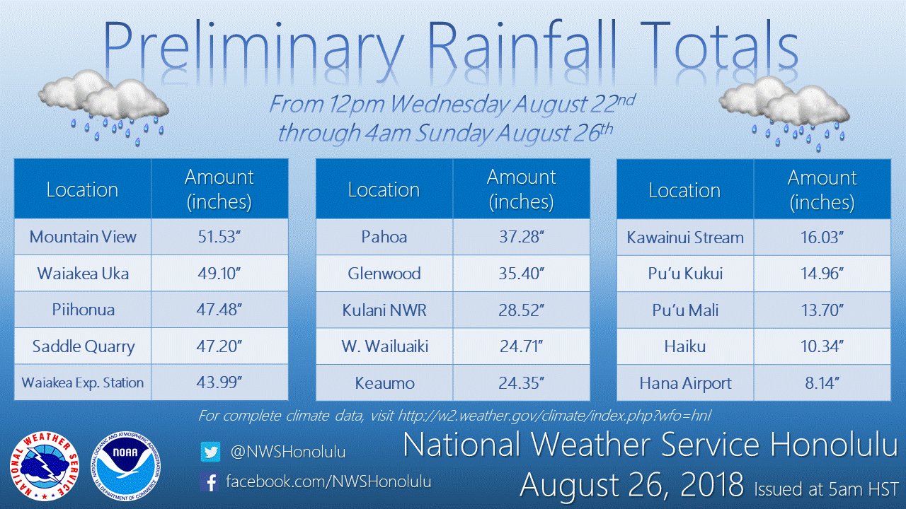
Hurricane Lane is the third wettest so far. It is very close to dethroning Hurricane Hiki, which dumped 52 inches of rain in 1950. Harvey remains the wettest for America with over 60 inches of rain. Interesting to note this happened a year after Harvey.
Wettest American Tropical Cyclones
Harvey (2017) 70 Inches (Doppler radar estimated)
Hiki (1950) 52 Inches
Lane (2018) 51.52 Inches
Amelia (1978) 48.00 Inches
Easy (1950) 45.20 Inches
Claudette (1979) 45.00 Inches
TD #15 (1970) 41.68 Inches
Allison (2001) 40.68 Inches
Hurricane #2 (1921) 40.00 Inches
Paul (2000) 38.76 Inches
Georges (1998) 38.46 Inches
https://en.wikipedia.org/wiki/List_of_w ... ted_States
Harvey, Amelia, Claudette, Allison, and Hurricane #2 (1921) occurred in Texas. Claudette dumped 43 inches in 24 hours, while Hurricane #2 (1921) dumped 38.20 inches in 24 hours including 32 inches in 12 hours! Interesting to note Texas holds many top 10 for wettest tropical cyclones in America.
Looks like forecast for Holiday weekend will be chance of rain!

-
stormlover
- Posts: 439
- Joined: Wed Dec 04, 2013 10:21 am
- Location: Lumberton TX
- Contact:
Seems to be going back and forth between Louisiana and South Texas with each run. Much will depend on timing and the strength of the ridge.
-
srainhoutx
- Site Admin
- Posts: 19616
- Joined: Tue Feb 02, 2010 2:32 pm
- Location: Maggie Valley, NC
- Contact:
I see no change regarding our sensible weather as the Long Labor Day Holiday Weekend begins and ends. What you see out there today will likely be the same pattern we can expect during the Long Weekend. The 7 Day QPF charts paint an unsettled pattern with a series of inverted troughs moving West beneath the flattened out Upper Ridge across the Mid West into the Mid Atlantic.
Beyond the 7 Day forecast, there is noise in the models regarding later next week, but I see nothing at this time to get too worked up over. We are certainly in better shape today than we were a year ago at this time... 
Carla/Alicia/Jerry(In The Eye)/Michelle/Charley/Ivan/Dennis/Katrina/Rita/Wilma/Humberto/Ike/Harvey
Member: National Weather Association
Facebook.com/Weather Infinity
Twitter @WeatherInfinity
Member: National Weather Association
Facebook.com/Weather Infinity
Twitter @WeatherInfinity
-
MontgomeryCoWx

- Posts: 2356
- Joined: Wed Dec 14, 2011 4:31 pm
- Location: Weimar, TX
- Contact:
It can rain every day but 9/7 and 9/8 in CS. Please dont rain for Clemson weekend.
Team #NeverSummer
Must say the modeling is becoming a tad interesting.
Plenty of Euro ensembles bring the some energy to the WGOM. 18z gfs has energy moving towards the mid and upper Texas coast next weekend.
All in the long range but model watching over the next few days is warranted...
Plenty of Euro ensembles bring the some energy to the WGOM. 18z gfs has energy moving towards the mid and upper Texas coast next weekend.
All in the long range but model watching over the next few days is warranted...
-
Texaspirate11

- Posts: 1278
- Joined: Tue Dec 31, 2013 12:24 am
- Contact:
EURO shows 4 storms coming off Africa...in September hopefully they'll recurve
Wish I could post the map but I always have trouble....
Wish I could post the map but I always have trouble....
Just because you're disabled, you don't have to be a victim
Be Weather Aware & Prepared!
Barbara Jordan Winner in Media
Disability Integration Consultant
Be Weather Aware & Prepared!
Barbara Jordan Winner in Media
Disability Integration Consultant
We are entering the more active part of the hurricane season.
-
srainhoutx
- Site Admin
- Posts: 19616
- Joined: Tue Feb 02, 2010 2:32 pm
- Location: Maggie Valley, NC
- Contact:
There has been a lot of chatter the past few days about the model storm entering the Gulf next week so let's investigate what those computer models are possibly "sniffing out". MIMIC does show a tropical wave breaking across the Caribbean Islands this morning with one twave entering the Eastern Caribbean Sea and another further N that should cross the Greater Antilles and the Bahamas.

Currently the Weather Prediction Center believes this Northern wave will be nothing more than another inverted trough like we are currently experiencing. Another inverted trough passes by our Area Labor Day Weekend and the wave that the models attempt to spin up is a inverted trough crossing S Florida and nearing the Northern Gulf on Day 7 of the WPC Surface Charts. Remember the models struggle with TC Genesis, so take those ominous computer graphics with a grain of salt until we see thunderstorms converging and organizing. If that begin to occur, then we can monitor a bit more closely.
Currently the Weather Prediction Center believes this Northern wave will be nothing more than another inverted trough like we are currently experiencing. Another inverted trough passes by our Area Labor Day Weekend and the wave that the models attempt to spin up is a inverted trough crossing S Florida and nearing the Northern Gulf on Day 7 of the WPC Surface Charts. Remember the models struggle with TC Genesis, so take those ominous computer graphics with a grain of salt until we see thunderstorms converging and organizing. If that begin to occur, then we can monitor a bit more closely.
- Attachments
-
Carla/Alicia/Jerry(In The Eye)/Michelle/Charley/Ivan/Dennis/Katrina/Rita/Wilma/Humberto/Ike/Harvey
Member: National Weather Association
Facebook.com/Weather Infinity
Twitter @WeatherInfinity
Member: National Weather Association
Facebook.com/Weather Infinity
Twitter @WeatherInfinity
-
Texaspirate11
- Posts: 1278
- Joined: Tue Dec 31, 2013 12:24 am
- Contact:
Thank you! 
Just because you're disabled, you don't have to be a victim
Be Weather Aware & Prepared!
Barbara Jordan Winner in Media
Disability Integration Consultant
Be Weather Aware & Prepared!
Barbara Jordan Winner in Media
Disability Integration Consultant


Nothing to get worked up about at the moment, but while the Euro and GFS show some 'energy' heading our way late next week, the NAM is also trying to spin something up in the central and eastern Gulf come this Saturday. Time only goes out till Saturday afternoon, but regardless of development, a slug of moisture looks to head to the Louisiana and SETX coast early next week (Monday/Tuesday) then we will need to monitor if any development occurs with those waves coming off of Africa as that could bring more enhanced moisture heading into next weekend.
For what its worth, shear is fairly well relaxed in the Gulf right now and shear is forecasted to relax in the Caribbean by the weekend. SSTs have also had a rise off the coast of Africa, in the Atlantic up to the Caribbean where not too long ago water temps were well below average. Last, a stout HP off the Carolina coast looks to stay in place through the next 7-10 days giving a general good steering flow for any tropical moisture to work its way through the Caribbean/Bahamas into the Gulf instead of curving up the East coast. Good news for them as that HP will act as a block. GFS is picking up on a possible hurricane forming off the coast of Africa and the Cabo Verde Islands by late Thursday or early Friday, but quickly recurving into the Atlantic - well east of Bermuda.
Still plenty of time to watch everything unfold, but heart of the season is definitely making its presence known.
Blake
Boomer Sooner
Boomer Sooner
-
stormlover
- Posts: 439
- Joined: Wed Dec 04, 2013 10:21 am
- Location: Lumberton TX
- Contact:
other GFS model has strong tropical storm headed towards Sw/LA
-
Texaspirate11
- Posts: 1278
- Joined: Tue Dec 31, 2013 12:24 am
- Contact:
2 p.m. disco
A vigorous low pressure area associated with a tropical wave is forecast to form between the coast of Africa and the Cabo Verde Islands on Thursday. Conditions appears to be favorable for development, and a tropical depression could form over the weekend while the system moves west-northwestward near the Cabo Verde Islands and the adjacent Atlantic. This system is expected to bring rains and gusty winds to those islands in two or three days, and interests in that region should monitor the progress of this disturbance.
* Formation chance through 48 hours...low...30 percent.
* Formation chance through 5 days...medium...60 percent.
Just because you're disabled, you don't have to be a victim
Be Weather Aware & Prepared!
Barbara Jordan Winner in Media
Disability Integration Consultant
Be Weather Aware & Prepared!
Barbara Jordan Winner in Media
Disability Integration Consultant
Being mostly facetious here - But this is another holiday weekend. You know how things get interesting around holidays here.