
I agree, but SPC is seeing something persuading them to issue a Watch shortly. I trust their eyes more than mine.jasons wrote:I don’t see any sort of break this afternoon which would allow much instability to build. Looks like a mostly rain event to me.
OCTOBER 2018 - Stormy Halloween
Hope that's the case. Southwest just lost my future business. They cancelled many flights into Houston earlier when other carriers landed +/- 30 minutes around when ours should have. Lost an entire day of vacation and I'm not even home yet. Worried about the 2nd flight they have us on getting in at 9jasons wrote:I don’t see any sort of break this afternoon which would allow much instability to build. Looks like a mostly rain event to me.
-
Texaspirate11

- Posts: 1278
- Joined: Tue Dec 31, 2013 12:24 am
- Contact:
You were right on Steve
TORNADO WATCH 416 IS IN EFFECT UNTIL 1000 PM CDT FOR THE
FOLLOWING LOCATIONS
TX
. TEXAS COUNTIES INCLUDED ARE
ANDERSON ANGELINA AUSTIN
BASTROP BOWIE BRAZORIA
BRAZOS BURLESON CALDWELL
CAMP CASS CHAMBERS
CHEROKEE COLORADO FALLS
FAYETTE FORT BEND FRANKLIN
FREESTONE GALVESTON GONZALES
GREGG GRIMES HARDIN
HARRIS HARRISON HENDERSON
HOUSTON JASPER JEFFERSON
LAVACA LEE LEON
LIBERTY LIMESTONE MADISON
MARION MILAM MONTGOMERY
MORRIS NACOGDOCHES NEWTON
ORANGE PANOLA POLK
RED RIVER ROBERTSON RUSK
SABINE SAN AUGUSTINE SAN JACINTO
SHELBY SMITH TITUS
TRINITY TYLER UPSHUR
VAN ZANDT WALKER WALLER
WASHINGTON WHARTON WOOD
Just because you're disabled, you don't have to be a victim
Be Weather Aware & Prepared!
Barbara Jordan Winner in Media
Disability Integration Consultant
Be Weather Aware & Prepared!
Barbara Jordan Winner in Media
Disability Integration Consultant
That storm Southwest of town is starting to look suspiciously supercelly
-
Stormrider
- Posts: 109
- Joined: Wed Feb 03, 2010 11:50 pm
- Contact:
Received a quick 1+ inches in Galveston this afternoon. And this isn't the main event.


Was just about to mention that... If you're in the Sugar Land/Missouri City area... keep a close eye to the cell approaching your SW. Radar shows rotation is increasing. This storm is heading NE and will work itself into SW Harris County near Bellaire in the next 30-45 minutes.sau27 wrote:That storm Southwest of town is starting to look suspiciously supercelly
Blake
Boomer Sooner
Boomer Sooner

I'm seeing a little right turn. NW Harris Co - keep your eyes and iPhones peeled.Belmer wrote:Was just about to mention that... If you're in the Sugar Land/Missouri City area... keep a close eye to the cell approaching your SW. Radar shows rotation is increasing. This storm is heading NE and will work itself into SW Harris County near Bellaire in the next 30-45 minutes.sau27 wrote:That storm Southwest of town is starting to look suspiciously supercelly
TORNADO WARNING for that storm to the SW of Harris County.
906
WFUS54 KHGX 312017
TORHGX
TXC157-201-312045-
/O.NEW.KHGX.TO.W.0009.181031T2017Z-181031T2045Z/
BULLETIN - EAS ACTIVATION REQUESTED
Tornado Warning
National Weather Service Houston/Galveston TX
Issued by National Weather Service Lake Charles LA
317 PM CDT WED OCT 31 2018
The National Weather Service in League City has issued a
* Tornado Warning for...
Northeastern Fort Bend County in southeastern Texas...
South central Harris County in southeastern Texas...
* Until 345 PM CDT.
* At 317 PM CDT, a severe thunderstorm capable of producing a tornado
was located over southwestern Riverstone, or over First Colony,
moving northeast at 20 mph.
HAZARD...Tornado.
SOURCE...Radar indicated rotation.
IMPACT...Flying debris will be dangerous to those caught without
shelter. Mobile homes will be damaged or destroyed.
Damage to roofs, windows, and vehicles will occur. Tree
damage is likely.
* Locations impacted include...
Northwestern Pearland, Sugar Land, Missouri City, eastern
Rosenberg, Stafford, Bellaire, Hunters Creek Village, Bunker Hill
Village, Piney Point Village, Town West, First Colony, Fresno,
Spring Branch West, Meadows Place, Hedwig Village, Arcola,
Thompsons, Westbury, New Territory and Westwood.
PRECAUTIONARY/PREPAREDNESS ACTIONS...
TAKE COVER NOW! Move to an interior room on the lowest floor of a
sturdy building. Avoid windows. If you are outdoors, in a mobile
home, or in a vehicle, move to the closest substantial shelter and
protect yourself from flying debris.
&&
LAT...LON 2958 9537 2959 9538 2958 9539 2958 9543
2952 9544 2942 9560 2955 9574 2979 9553
2959 9535
TIME...MOT...LOC 2017Z 226DEG 16KT 2955 9561
TORNADO...RADAR INDICATED
HAIL...<.75IN
Last edited by Belmer on Wed Oct 31, 2018 3:23 pm, edited 1 time in total.
Blake
Boomer Sooner
Boomer Sooner
https://twitter.com/iembot_hgx
gusting to 25mph in Austin, 21mph in Caldwell, 25mph in Bay City, 30mph Port Lavaca
https://www.wrh.noaa.gov/zoa/mwmap2.php ... =0&limit=1
winds at different levels
https://earth.nullschool.net/#current/w ... 32.69,2827
https://earth.nullschool.net/#current/w ... 32.69,2827
https://earth.nullschool.net/#current/w ... 32.69,2827
-
srainhoutx

- Site Admin

- Posts: 19616
- Joined: Tue Feb 02, 2010 2:32 pm
- Location: Maggie Valley, NC
- Contact:
Folks in Austin, Waller and W/NW Harris County need to keep an eye out as well. The cell approaching SW Austin County may take on super cellular characteristics as well
Carla/Alicia/Jerry(In The Eye)/Michelle/Charley/Ivan/Dennis/Katrina/Rita/Wilma/Humberto/Ike/Harvey
Member: National Weather Association
Facebook.com/Weather Infinity
Twitter @WeatherInfinity
Member: National Weather Association
Facebook.com/Weather Infinity
Twitter @WeatherInfinity
Hopefully all this early day storming works the air over in time for the cold front to just rain.
-
srainhoutx
- Site Admin
- Posts: 19616
- Joined: Tue Feb 02, 2010 2:32 pm
- Location: Maggie Valley, NC
- Contact:
srainhoutx wrote:Folks in Austin, Waller and W/NW Harris County need to keep an eye out as well. The cell approaching SW Austin County may take on super cellular characteristics as well
Tornado Warning coming for this cell. Reports of a tornado S of Sealy.
BULLETIN - EAS ACTIVATION REQUESTED
TORNADO WARNING
NATIONAL WEATHER SERVICE HOUSTON/GALVESTON TX
327 PM CDT WED OCT 31 2018
THE NATIONAL WEATHER SERVICE IN LEAGUE CITY HAS ISSUED A
* TORNADO WARNING FOR...
EASTERN COLORADO COUNTY IN SOUTHEASTERN TEXAS...
SOUTHEASTERN AUSTIN COUNTY IN SOUTHEASTERN TEXAS...
* UNTIL 345 PM CDT.
* AT 326 PM CDT, A SEVERE THUNDERSTORM CAPABLE OF PRODUCING A TORNADO
WAS LOCATED NEAR SEALY, MOVING NORTHEAST AT 15 MPH.
A TORNAODO WAS SIGHTED JUST SOUTH OF SEALY AT APPROXIMATELY 320 PM
CDT.
HAZARD...TORNADO.
SOURCE...RADAR INDICATED ROTATION.
IMPACT...FLYING DEBRIS WILL BE DANGEROUS TO THOSE CAUGHT WITHOUT
SHELTER. MOBILE HOMES WILL BE DAMAGED OR DESTROYED.
DAMAGE TO ROOFS, WINDOWS, AND VEHICLES WILL OCCUR. TREE
DAMAGE IS LIKELY.
* THIS DANGEROUS STORM WILL BE NEAR...
SEALY AROUND 345 PM CDT.
PRECAUTIONARY/PREPAREDNESS ACTIONS...
TAKE COVER NOW! MOVE TO A BASEMENT OR AN INTERIOR ROOM ON THE LOWEST
FLOOR OF A STURDY BUILDING. AVOID WINDOWS. IF YOU ARE OUTDOORS, IN A
MOBILE HOME, OR IN A VEHICLE, MOVE TO THE CLOSEST SUBSTANTIAL SHELTER
AND PROTECT YOURSELF FROM FLYING DEBRIS.
Carla/Alicia/Jerry(In The Eye)/Michelle/Charley/Ivan/Dennis/Katrina/Rita/Wilma/Humberto/Ike/Harvey
Member: National Weather Association
Facebook.com/Weather Infinity
Twitter @WeatherInfinity
Member: National Weather Association
Facebook.com/Weather Infinity
Twitter @WeatherInfinity
https://twitter.com/NWStornado
https://weather.cod.edu/satrad/nexrad/i ... X-N0U-1-24
https://weather.cod.edu/satrad/nexrad/i ... X-N0S-1-24

https://weather.cod.edu/satrad/nexrad/i ... X-N0U-1-24
https://weather.cod.edu/satrad/nexrad/i ... X-N0S-1-24
Last edited by unome on Wed Oct 31, 2018 3:33 pm, edited 1 time in total.
NEW TORNADO WARNING for the storm south of Sealy.
710
WFUS54 KHGX 312027
TORHGX
TXC015-089-312045-
/O.NEW.KHGX.TO.W.0010.181031T2027Z-181031T2045Z/
BULLETIN - EAS ACTIVATION REQUESTED
Tornado Warning
National Weather Service Houston/Galveston TX
327 PM CDT WED OCT 31 2018
The National Weather Service in League City has issued a
* Tornado Warning for...
Eastern Colorado County in southeastern Texas...
Southeastern Austin County in southeastern Texas...
* Until 345 PM CDT.
* At 326 PM CDT, a severe thunderstorm capable of producing a tornado
was located near Sealy, moving northeast at 15 mph.
A tornaodo was sighted just south of Sealy at approximately 320 PM
CDT.
HAZARD...Tornado.
SOURCE...Radar indicated rotation.
IMPACT...Flying debris will be dangerous to those caught without
shelter. Mobile homes will be damaged or destroyed.
Damage to roofs, windows, and vehicles will occur. Tree
damage is likely.
* This dangerous storm will be near...
Sealy around 345 PM CDT.
PRECAUTIONARY/PREPAREDNESS ACTIONS...
TAKE COVER NOW! Move to a basement or an interior room on the lowest
floor of a sturdy building. Avoid windows. If you are outdoors, in a
mobile home, or in a vehicle, move to the closest substantial shelter
and protect yourself from flying debris.
&&
LAT...LON 2960 9627 2964 9632 2982 9618 2970 9604
TIME...MOT...LOC 2026Z 228DEG 12KT 2968 9618
TORNADO...RADAR INDICATED
HAIL...<.75IN
Blake
Boomer Sooner
Boomer Sooner
https://twitter.com/iembot_hgx/status/1 ... 1349278721
IEMBot HGX
@iembot_hgx
HOUSTON/HULL FIELD,TX (SGR) ASOS reports Tornado
1:38 PM - 31 Oct 2018 from Sugar Land, TX
https://twitter.com/FBCSO/status/1057729089413541888
FBCSO Texas
Verified account @FBCSO
Receiving multiple reports of tornado touchdown FM 2759 / Agnes Rd. Not confirmed by deputy. @NWSHouston #HouWx
Last edited by unome on Wed Oct 31, 2018 3:43 pm, edited 1 time in total.
-
srainhoutx
- Site Admin
- Posts: 19616
- Joined: Tue Feb 02, 2010 2:32 pm
- Location: Maggie Valley, NC
- Contact:
Supercell nearing Sealy is very persistent. HGX states this is a dangerous storm. Large hail likely as well
Carla/Alicia/Jerry(In The Eye)/Michelle/Charley/Ivan/Dennis/Katrina/Rita/Wilma/Humberto/Ike/Harvey
Member: National Weather Association
Facebook.com/Weather Infinity
Twitter @WeatherInfinity
Member: National Weather Association
Facebook.com/Weather Infinity
Twitter @WeatherInfinity
-
srainhoutx
- Site Admin
- Posts: 19616
- Joined: Tue Feb 02, 2010 2:32 pm
- Location: Maggie Valley, NC
- Contact:
BULLETIN - EAS ACTIVATION REQUESTED
TORNADO WARNING
NATIONAL WEATHER SERVICE HOUSTON/GALVESTON TX
345 PM CDT WED OCT 31 2018
THE NATIONAL WEATHER SERVICE IN LEAGUE CITY HAS ISSUED A
* TORNADO WARNING FOR...
SOUTHEASTERN AUSTIN COUNTY IN SOUTHEASTERN TEXAS...
SOUTHWESTERN WALLER COUNTY IN SOUTHEASTERN TEXAS...
* UNTIL 400 PM CDT.
* AT 344 PM CDT, A CONFIRMED TORNADO WAS LOCATED NEAR SEALY, MOVING
NORTHEAST AT 20 MPH.
HAZARD...DAMAGING TORNADO AND QUARTER SIZE HAIL.
SOURCE...PUBLIC CONFIRMED TORNADO.
IMPACT...FLYING DEBRIS WILL BE DANGEROUS TO THOSE CAUGHT WITHOUT
SHELTER. MOBILE HOMES WILL BE DAMAGED OR DESTROYED.
DAMAGE TO ROOFS, WINDOWS, AND VEHICLES WILL OCCUR. TREE
DAMAGE IS LIKELY.
* THE TORNADO WILL BE NEAR...
SAN FELIPE AROUND 400 PM CDT.
PRECAUTIONARY/PREPAREDNESS ACTIONS...
TO REPEAT, A TORNADO IS ON THE GROUND. TAKE COVER NOW! MOVE TO A
BASEMENT OR AN INTERIOR ROOM ON THE LOWEST FLOOR OF A STURDY
BUILDING. AVOID WINDOWS. IF YOU ARE OUTDOORS, IN A MOBILE HOME, OR IN
A VEHICLE, MOVE TO THE CLOSEST SUBSTANTIAL SHELTER AND PROTECT
YOURSELF FROM FLYING DEBRIS.
Carla/Alicia/Jerry(In The Eye)/Michelle/Charley/Ivan/Dennis/Katrina/Rita/Wilma/Humberto/Ike/Harvey
Member: National Weather Association
Facebook.com/Weather Infinity
Twitter @WeatherInfinity
Member: National Weather Association
Facebook.com/Weather Infinity
Twitter @WeatherInfinity
-
srainhoutx
- Site Admin
- Posts: 19616
- Joined: Tue Feb 02, 2010 2:32 pm
- Location: Maggie Valley, NC
- Contact:
Tornado Warning for Ft Bend/Harris Counties has expired
Carla/Alicia/Jerry(In The Eye)/Michelle/Charley/Ivan/Dennis/Katrina/Rita/Wilma/Humberto/Ike/Harvey
Member: National Weather Association
Facebook.com/Weather Infinity
Twitter @WeatherInfinity
Member: National Weather Association
Facebook.com/Weather Infinity
Twitter @WeatherInfinity
While the Fort Bend Tornado Warning has expired and the storm has elongated across Harris County... keep an eye on the southern flank of the cell over Missouri City. Rotation there is increasing again and nice inflow coming in on it.
Blake
Boomer Sooner
Boomer Sooner
https://www.spc.noaa.gov/products/outlo ... 12011.html
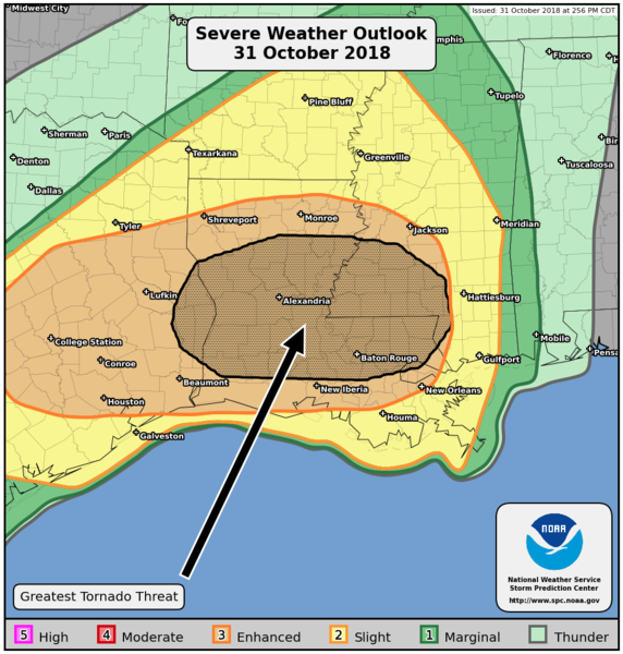
PUBLIC SEVERE WEATHER OUTLOOK
NWS STORM PREDICTION CENTER NORMAN OK
0310 PM CDT WED OCT 31 2018
...Severe thunderstorms expected over parts of the lower Mississippi
Valley this evening and overnight...
* LOCATIONS...
Louisiana
Southern and Central Mississippi
East Texas
* HAZARDS...
A few intense tornadoes
Scattered damaging winds
Isolated large hail
* SUMMARY...
The greatest risk for severe thunderstorms, capable of producing
damaging winds, hail, and tornadoes, exists from southeast Texas
to the lower Mississippi Valley through tonight.
Preparedness actions...
Tornadoes at night can be particularly dangerous because they
are usually fast-moving and difficult to see. Stay tuned to
NOAA Weather Radio, weather.gov, or other media for watches and
warnings. A tornado watch means that conditions are favorable
for tornadoes to form during the next several hours. If a tornado
warning is issued for your area, move to a place of safety,
ideally in a basement or interior room on the lowest floor of a
sturdy building.
&&
..Gleason.. 10/31/2018
$$