
FEBRUARY 2019: Cold Front & Storm Chances
Can confirm hail here at my house. Pea size hail. First time it’s hailed at my house in several years.
-
Katdaddy

- Global Moderator

- Posts: 2502
- Joined: Thu Feb 04, 2010 8:18 am
- Location: League City, Tx
- Contact:
...A SEVERE THUNDERSTORM WARNING REMAINS IN EFFECT UNTIL 500 PM CST
FOR EAST CENTRAL WHARTON AND SOUTHWESTERN FORT BEND COUNTIES...
At 434 PM CST, a severe thunderstorm was located near Wharton, moving
east at 30 mph.
HAZARD...Quarter size hail.
SOURCE...Emergency management.
IMPACT...Damage to vehicles is expected.
Locations impacted include...
Wharton, Beasley, Kendleton and Hungerford.
PRECAUTIONARY/PREPAREDNESS ACTIONS...
Prepare immediately for large hail and deadly cloud to ground
lightning. Seek shelter inside a well-built structure. Stay away from
windows.
To report severe weather contact your nearest law enforcement agency.
They will send your report to the National Weather Service office in
League City.

Don't let the movement of the storms out west fool you too much. While the general movement is from the SW to the NE, the southern cell that has been producing a Severe Thunderstorm Warning is moving generally eastward and should impact areas south of I-10 this evening. Whether the intensity remains severe and produces hail for our area this evening will remain to be seen.
Also beginning to think if that complex remains its intensity as it moves over Houston, we could be looking at some minor street flooding. Areas south of I-10 that received about half-an-inch yesterday could see a quick rise in creeks and bayous as this could drop an easy 1-3 inches. Grounds are fully saturated and much (if not all) of the rain that falls will quickly runoff. Looks like the storm is starting to slowly slow down a little bit too...
Also beginning to think if that complex remains its intensity as it moves over Houston, we could be looking at some minor street flooding. Areas south of I-10 that received about half-an-inch yesterday could see a quick rise in creeks and bayous as this could drop an easy 1-3 inches. Grounds are fully saturated and much (if not all) of the rain that falls will quickly runoff. Looks like the storm is starting to slowly slow down a little bit too...
Blake
Boomer Sooner
Boomer Sooner
It’s flooded here at my house. I’m 10 miles north of El Campo and 10 miles west of Wharton. Biggest rain event we’ve had here in months.Belmer wrote: ↑Tue Feb 26, 2019 5:05 pm Don't let the movement of the storms out west fool you too much. While the general movement is from the SW to the NE, the southern cell that has been producing a Severe Thunderstorm Warning is moving generally eastward and should impact areas south of I-10 this evening. Whether the intensity remains severe and produces hail for our area this evening will remain to be seen.
Also beginning to think if that complex remains its intensity as it moves over Houston, we could be looking at some minor street flooding. Areas south of I-10 that received about half-an-inch yesterday could see a quick rise in creeks and bayous as this could drop an easy 1-3 inches. Grounds are fully saturated and much (if not all) of the rain that falls will quickly runoff. Looks like the storm is starting to slowly slow down a little bit too...
Doesn't surprise me, seeing radar estimates of 2.5 inches just west of Wharton with still some developing moderate showers behind that storm. Could pick up an easy 3 even possibly 4 inches before the evening is over for you, Cp17.
I think I remember you mentioning it has been dry out there too. With dead vegetation (though slowly starting to turn green again) and lower sun angle, still doesn't take much rain around here around this time of year to quickly cause flooding despite how dry the ground may be.
My hunch... this is only a sign of what may potentially be a very wet Spring ahead. Everything I've been seeing points to an active March extending into April. Hope next week is the last of the cold. Ready for the Gulf waters to warm up and get this dreary foggy/misty weather out of here.
Blake
Boomer Sooner
Boomer Sooner
BULLETIN - IMMEDIATE BROADCAST REQUESTED
Severe Thunderstorm Warning
National Weather Service Houston/Galveston TX
454 PM CST TUE FEB 26 2019
The National Weather Service in League City has issued a
* Severe Thunderstorm Warning for...
East central Wharton County in southeastern Texas...
Southwestern Fort Bend County in southeastern Texas...
* Until 530 PM CST.
* At 453 PM CST, a severe thunderstorm was located near Wharton,
moving east at 25 mph.
HAZARD...Quarter size hail.
SOURCE...Radar indicated. At 4:15 PM, quarter-size hail was
reported at New Taiton.
IMPACT...Damage to vehicles is expected.
* Locations impacted include...
Southwestern Sugar Land, southeastern Rosenberg, Wharton,
Needville, Pleak, Fairchilds, Thompsons, Brazos Bend State Park,
Greatwood, New Territory and Hungerford.
PRECAUTIONARY/PREPAREDNESS ACTIONS...
For your protection move to an interior room on the lowest floor of a
building.
&&
LAT...LON 2931 9608 2939 9610 2959 9568 2936 9560
TIME...MOT...LOC 2253Z 252DEG 23KT 2937 9607
HAIL...1.00IN
WIND...<50MPH
Absolutely. I'm watching it closely here in Pasadena. Quarter size hail may leave a few dings on a vehicle. I just recently bought a new car and don't have the means to park it in my garage at the moment. So I'll be watching closely in the case I need to find a covered spot.
Blake
Boomer Sooner
Boomer Sooner
I just checked the gauge here and we’ve picked up 4.3” so far. Probably will be 5” before it’s over.Belmer wrote: ↑Tue Feb 26, 2019 5:20 pmDoesn't surprise me, seeing radar estimates of 2.5 inches just west of Wharton with still some developing moderate showers behind that storm. Could pick up an easy 3 even possibly 4 inches before the evening is over for you, Cp17.
I think I remember you mentioning it has been dry out there too. With dead vegetation (though slowly starting to turn green again) and lower sun angle, still doesn't take much rain around here around this time of year to quickly cause flooding despite how dry the ground may be.
My hunch... this is only a sign of what may potentially be a very wet Spring ahead. Everything I've been seeing points to an active March extending into April. Hope next week is the last of the cold. Ready for the Gulf waters to warm up and get this dreary foggy/misty weather out of here.
-
Katdaddy
- Global Moderator
- Posts: 2502
- Joined: Thu Feb 04, 2010 8:18 am
- Location: League City, Tx
- Contact:
BULLETIN - IMMEDIATE BROADCAST REQUESTED
Severe Thunderstorm Warning
National Weather Service Houston/Galveston TX
529 PM CST TUE FEB 26 2019
The National Weather Service in League City has issued a
* Severe Thunderstorm Warning for...
East central Wharton County in southeastern Texas...
Southwestern Fort Bend County in southeastern Texas...
West central Brazoria County in southeastern Texas...
* Until 615 PM CST.
* At 529 PM CST, a severe thunderstorm was located near Boling-Iago,
or 7 miles east of Wharton, moving east at 20 mph.
HAZARD...Quarter size hail.
SOURCE...Radar indicated.
IMPACT...Damage to vehicles is expected.
* Locations impacted include...
Needville, Fairchilds, Boling-Iago and Damon.
PRECAUTIONARY/PREPAREDNESS ACTIONS...
Prepare immediately for large hail and deadly cloud to ground
lightning. Seek shelter inside a well-built structure. Stay away from
windows.
To report severe weather, contact your nearest law enforcement
agency. They will send your report to the National Weather Service
office in League City.
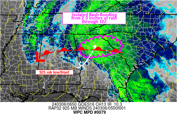
Mesoscale Precipitation Discussion 0079
NWS Weather Prediction Center College Park MD
621 PM EST Tue Feb 26 2019
Areas affected...Near and southwest of Houston, TX
Concerning...Heavy rainfall...Flash flooding possible
Valid 262320Z - 270320Z
Summary...Thunderstorms continue to broaden to the west of the
Houston Metroplex, with some indications of embedded mesocyclones.
Hourly rain totals to 1.5" with local amounts to 3" are possible.
Discussion...Storms continue to blossom to the southeast of an
upper level disturbance moving across the TX Hill Country and
somewhat northeast of a frontal wave near Bloomington, TX.
Equally troubling is the backbuilding/redeveloping storms into
southern Lavaca county. Precipitable water values have risen to
1.5-1.7". Inflow at 850 hPa is 15-20 kts from the southwest.
Effective bulk shear is near 40 kts, which has been enough to
develop the occasional mesocyclone over the past few hours. ML
CAPE within the warm sector is 1000-1500 J/kg, while MU CAPE
values of 1000-2000 J/kg inhabit the Piney Woods and Big Thicket
of eastern TX.
Correcting for hail contamination, hourly rain totals have
recently jumped to 1.5". The mesoscale guidance, particularly the
18z 3 km NAM CONEST, show the potential for local 2-3" of rainfall
near and southwest of Houston, which appears to be becoming
realized at this time. This is close to the regional flash flood
guidance values. Should the storms propagate into Houston itself,
the usual heavy rain related issues within their urban area would
result. Believe that storms should become more mobile with any
cell backbuilding/ redevelopment ceasing by 01z and increased
elevation over the boundary with time as the incoming shortwave
begins to progress and the 700 hPa wind flow begins to veer
thereafter. Used a four hour window as a precaution.
Roth
ATTN...WFO...CRP...EWX...HGX...
ATTN...RFC...WGRFC...
https://twitter.com/NWSHouston/status/1 ... 9161390081
NWS Houston
Verified account @NWSHouston
NWS Houston
Verified account @NWSHouston
550p: We're seeing signs of very large hail 10-15k feet above the ground in the warned storm. Some of that will melt away before anything hits the ground, but it does increase confidence in seeing quarter to ping pong ball sized hail in the most intense part of the storm.
Severe Weather Statement
National Weather Service Houston/Galveston TX
557 PM CST TUE FEB 26 2019
TXC039-157-481-270015-
/O.CON.KHGX.SV.W.0007.000000T0000Z-190227T0015Z/
Wharton TX-Fort Bend TX-Brazoria TX-
557 PM CST TUE FEB 26 2019
...A SEVERE THUNDERSTORM WARNING REMAINS IN EFFECT UNTIL 615 PM CST
FOR EASTERN WHARTON...SOUTH CENTRAL FORT BEND AND WEST CENTRAL
BRAZORIA COUNTIES...
At 557 PM CST, a severe thunderstorm was located near Needville, or
13 miles south of Rosenberg, moving east at 25 mph.
HAZARD...Ping pong ball size hail.
SOURCE...Radar indicated.
IMPACT...People and animals outdoors will be injured. Expect damage
to roofs, siding, windows, and vehicles.
Locations impacted include...
Needville and Damon.
PRECAUTIONARY/PREPAREDNESS ACTIONS...
Prepare immediately for large hail and deadly cloud to ground
lightning. Seek shelter inside a well-built structure. Stay away from
windows.
To report severe weather contact your nearest law enforcement agency.
They will send your report to the National Weather Service office in
League City.
&&
LAT...LON 2925 9590 2940 9583 2941 9568 2924 9565
TIME...MOT...LOC 2357Z 268DEG 23KT 2935 9576
HAIL...1.50IN
WIND...<50MPH
$$
Ping-pong ball hail reported in that storm now
Special Weather Statement
National Weather Service Houston/Galveston TX
609 PM CST TUE FEB 26 2019
TXZ227-237-337-270100-
Inland Brazoria TX-Fort Bend TX-Coastal Brazoria TX-
609 PM CST TUE FEB 26 2019
...SIGNIFICANT WEATHER ADVISORY FOR SOUTHEASTERN FORT BEND AND
NORTHEASTERN BRAZORIA COUNTIES UNTIL 700 PM CST...
At 609 PM CST, Doppler radar was tracking a strong thunderstorm over
Brazos Bend State Park, or 13 miles north of West Columbia, moving
east at 25 mph.
Dime size hail will be possible with this storm.
Locations impacted include...
Alvin, southern Manvel, Danbury, Iowa Colony, Hillcrest, Liverpool,
Bonney, Brazos Bend State Park, Chocolate Bayou, Rosharon and Juliff.
LAT...LON 2941 9569 2949 9525 2945 9524 2939 9521
2923 9518 2923 9566
TIME...MOT...LOC 0009Z 265DEG 24KT 2933 9564
$$
Severe Thunderstorm Warning
TXC039-157-270115-
/O.NEW.KHGX.SV.W.0008.190227T0024Z-190227T0115Z/
BULLETIN - IMMEDIATE BROADCAST REQUESTED
Severe Thunderstorm Warning
National Weather Service Houston/Galveston TX
624 PM CST TUE FEB 26 2019
The National Weather Service in League City has issued a
* Severe Thunderstorm Warning for...
Southeastern Fort Bend County in southeastern Texas...
Northeastern Brazoria County in southeastern Texas...
* Until 715 PM CST.
* At 624 PM CST, a severe thunderstorm was located over Brazos Bend
State Park, or 14 miles north of West Columbia, moving east at 20
mph.
HAZARD...Quarter size hail.
SOURCE...Radar indicated.
IMPACT...Damage to vehicles is expected.
* Locations impacted include...
Alvin, southern Manvel, Iowa Colony, Liverpool, Bonney, Brazos Bend
State Park, Chocolate Bayou, Rosharon and Juliff.
PRECAUTIONARY/PREPAREDNESS ACTIONS...
For your protection move to an interior room on the lowest floor of a
building.
&&
LAT...LON 2928 9568 2943 9567 2947 9526 2922 9522
TIME...MOT...LOC 0024Z 267DEG 17KT 2935 9559
HAIL...1.00IN
WIND...<50MPH
$$
League City down to Galveston expect some intense C2G lightning as this storm moves through. Quarter size and Ping Pong Ball size hail is also likely.
Relieved to see it will miss Pasadena.
First image is 'Vertically Integrated Liquid" which is an estimate of the total mass of precipitation in the clouds. Essentially this is a nice little hail core.
Relieved to see it will miss Pasadena.
First image is 'Vertically Integrated Liquid" which is an estimate of the total mass of precipitation in the clouds. Essentially this is a nice little hail core.
- Attachments
-
- Hail core
-
Last edited by Belmer on Tue Feb 26, 2019 6:50 pm, edited 1 time in total.
Blake
Boomer Sooner
Boomer Sooner

Up here, everything is falling apart as soon as it approaches.
About to be in the core of it. I hope the hail misses me.
