Page 20 of 21
Re: APRIL 2019: Mid Week Rain/Storms
Posted: Wed Apr 24, 2019 10:52 pm
by Cromagnum
All these storms roll into caps and we get nothing every time. Gonna be awesome when nothing is coming at all in the coming months...
Re: APRIL 2019: Mid Week Rain/Storms
Posted: Thu Apr 25, 2019 3:44 am
by unome
Re: APRIL 2019: Pleasant Warm Weekend Ahead
Posted: Thu Apr 25, 2019 5:55 am
by Katdaddy
Clearing skies this morning across SE TX. The cold front has moved off the coast pushing the thunderstorms into LA. Thankfully the line of thunderstorms was a non-event for the Houston-Galveston areas and now onward to beautiful weather through the weekend.
Re: APRIL 2019: Pleasant Warm Weekend Ahead
Posted: Thu Apr 25, 2019 7:04 am
by jasons2k
I got nothing. Was hoping for some rain. Looks like sprinklers may have to run this weekend.
I sent Jeff’s email out to my team yesterday. They will probably give me a hard time today like “thanks for scaring us for nothing!”
Re: APRIL 2019: Pleasant Warm Weekend Ahead
Posted: Thu Apr 25, 2019 7:36 am
by Cpv17
jasons wrote: ↑Thu Apr 25, 2019 7:04 am
I got nothing. Was hoping for some rain. Looks like sprinklers may have to run this weekend.
I sent Jeff’s email out to my team yesterday. They will probably give me a hard time today like “thanks for scaring us for nothing!”
Things don’t look very good for any rain across our area of the state for the next couple weeks. Models show around 1” or less.
Re: APRIL 2019: Pleasant Warm Weekend Ahead
Posted: Thu Apr 25, 2019 8:05 am
by CrashTestDummy
We received 0.08" overnight. Seems we got just enough rain to keep the fireflies grounded.
We heard a couple of rumbles, but nothing really scary.
Re: APRIL 2019: Pleasant Warm Weekend Ahead
Posted: Thu Apr 25, 2019 10:15 am
by Cromagnum
Maybe I can at least get this patio finished up and closed in before the rains bring the mosquito plague upon us. It can rain all it wants in May
Re: APRIL 2019: Pleasant Warm Weekend Ahead
Posted: Thu Apr 25, 2019 10:22 am
by tireman4
000
FXUS64 KHGX 251002
AFDHGX
Area Forecast Discussion
National Weather Service Houston/Galveston TX
502 AM CDT Thu Apr 25 2019
.DISCUSSION...
Showers/thunderstorms are exiting to the E/SE this morning as the
cold front moves into the coastal waters. With skies clearing and
drier air filtering down into the region, temperatures should re-
bound nicely by this afternoon. Highs to range from the lower 80s
to the upper 70s. Favorable radiational cooling conditions should
be in place tonight with lows ranging from the upper 50s to lower
60s inland...upper 60s along the coast. With the offshore flow in
place (albeit much lighter) we should see very similar conditions
for Fri.
With the flattening upper ridge and surface high pressure sliding
off to the east, onshore winds are set to return Sat. Fairly warm
temps are progged for the weekend as low-level moisture begins to
slowly creep back up. Our next best rain chances are still on tap
starting around next Tues. Models remain in decent agreement with
the development/eastward track of the next upper trof near the CA
Baja late Mon. The deepening SW winds aloft in response will help
to drag shortwave energy across the area by Tues. Extended models
are indicating that this next system will likely lift more N than
NE with time, and this could stall the next cold front well north
of the CWA. As such the warm/humid pattern may be sticking around
in the extended. 41
&&
.MARINE...
Weak Pacific high near San Angelo this morning will slowly drift
east leading to more more widespread west and northwest winds across
the coastal waters. In the short term though will have showers and
thunderstorms along and ahead of the cold front moving east out of
the area. SCEC in effect through 8 am for the 20-60nm waters for the
sea should be dropping off as seas diminish to closer to 4 feet from
the 5-6 feet early this morning. Second cold front Friday morning
brings in more northerly winds before relaxing Friday night into
Saturday. Onshore flow resumes and will be very persistent through
Thursday and possibly even next Saturday. Gradient does start to
tighten up Monday night and should see steady increase in seas as a
series of bursts of east and southeasterly winds arrive from the
south-central Gulf.
45
&&
.AVIATION...
Dry air intruding into the region but will have lower ceilings
IFR/MVFR to the south where the more moist air hasn`t been scoured
out yet. Showers through 11z near GLS. Expect improving flight
conditions at CXO/IAH/HOU/SGR/LBX/GLS in the next 2 to 3 hours as
the weak cold front pushes out into the Gulf becoming VFR. NW winds
relaxing tonight.
45
&&
.PRELIMINARY POINT TEMPS/POPS...
College Station (CLL) 81 60 83 60 84 / 0 0 0 0 0
Houston (IAH) 81 62 85 62 84 / 0 0 0 0 0
Galveston (GLS) 79 68 80 68 80 / 10 0 0 0 0
&&
.HGX WATCHES/WARNINGS/ADVISORIES...
TX...NONE.
GM...SMALL CRAFT SHOULD EXERCISE CAUTION until 10 AM CDT this morning
for the following zones: Waters from Freeport to Matagorda
Ship Channel TX from 20 to 60 NM...Waters from High Island
to Freeport TX from 20 to 60 NM.
&&
$$
Re: APRIL 2019: Pleasant Warm Weekend Ahead
Posted: Thu Apr 25, 2019 11:57 am
by tireman4
0 replies 0 retweets 1 like
Reply Retweet Like 1 Direct message
NCAA
Verified account
@NCAA
4m4 minutes ago
More
Our thoughts are with the @LaTechSports community after a devastating tornado traveled through campus last night. #WeAreLaTech
LA Tech Sports
0 replies 0 retweets 0 likes
Reply Retweet Like Direct message
Re: APRIL 2019: Pleasant Warm Weekend Ahead
Posted: Thu Apr 25, 2019 12:31 pm
by srainhoutx
Tornado yesterday evening in the B/CS area rated as an EF-2
Re: APRIL 2019: Pleasant Warm Weekend Ahead
Posted: Fri Apr 26, 2019 6:26 am
by unome
a busy tornado week
https://www.wpc.ncep.noaa.gov/exper/lsr ... autoreload
Screenshot_2019-04-26 Weather Prediction Center Local Storm Reports.png
Re: APRIL 2019: Pleasant Warm Weekend Ahead
Posted: Fri Apr 26, 2019 7:25 am
by srainhoutx
Another Chamber of Commerce weekend ahead weather wise. Wear sun screen if you are planning outdoor activities. Next weather maker looks to arrive as we begin the month of May. April has proven active in our SE Texas Region. Time to start looking toward June 1st and the beginning of Hurricane Season. Our Hurricane Central area of the Forum will be the place to watch as we explore what the upcoming Tropical Weather Season may bring.
Re: APRIL 2019: Pleasant Warm Weekend Ahead
Posted: Fri Apr 26, 2019 9:30 pm
by Katdaddy
A beautiful amazing Upper TX Coast sunset!
Re: APRIL 2019: Pleasant Warm Weekend Ahead
Posted: Sat Apr 27, 2019 10:08 am
by mckinne63
That is a great picture katdaddy! Stunning!
Re: APRIL 2019: Pleasant Warm Weekend Ahead
Posted: Sat Apr 27, 2019 1:26 pm
by Cpv17
This sucks


Re: APRIL 2019: Pleasant Warm Weekend Ahead
Posted: Sat Apr 27, 2019 8:58 pm
by unome
364 hrs out on the GFS might not be very accurate, that's all I've got

Re: APRIL 2019: Pleasant Warm Weekend Ahead
Posted: Sun Apr 28, 2019 7:58 am
by srainhoutx
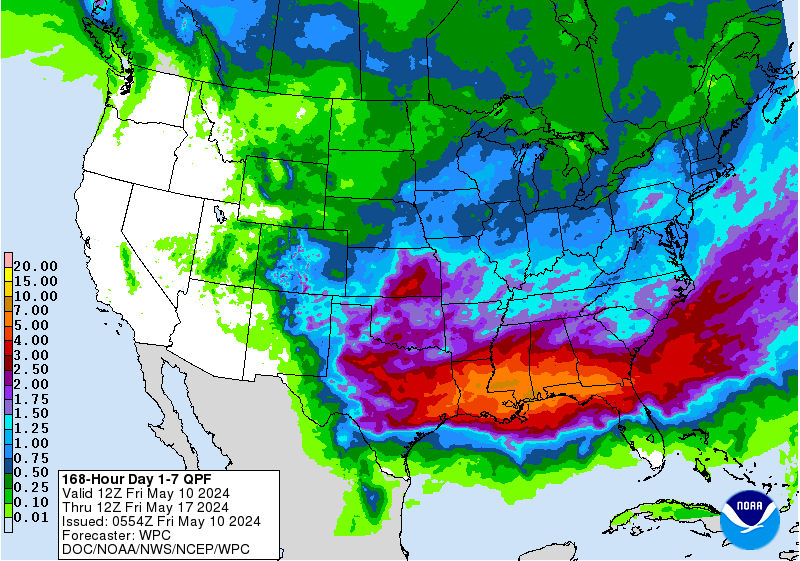
Pleasant weather looks to continue to the end of April. I see increasing chances of a multi day potential heavy rainfall event across a good portion of Texas including parts of our SE Texas Region as May begins. Time for a new May Topic as April ends...
Re: APRIL 2019: Pleasant Warm Weekend Ahead
Posted: Sun Apr 28, 2019 9:51 am
by Cpv17
Basically nothing for most of us according to this.
Re: APRIL 2019: Pleasant Warm Weekend Ahead
Posted: Sun Apr 28, 2019 2:08 pm
by Ptarmigan
The rainfall forecast models get the amount right, but not always the location.
Re: APRIL 2019: Pleasant Warm Weekend Ahead
Posted: Sun Apr 28, 2019 4:54 pm
by Cpv17
According to the 12z Euro, next Saturday is the day to watch for us here in southeast TX.
