February Weather Discussion. Wild Winter Storms?

General Weather Discussions and Analysis
User avatar
C2G
Posts: 236
Joined: Wed Feb 03, 2010 8:55 pm
Location: NW Galveston County
Contact:

snowman65 wrote:This must have been the biggest BUST for us in some time.......
Be careful or you'll get responses similar to this. :shock:
I happen to agree with you.
Candy Cane wrote: What's just about in The Woodlands? It has snowed in many places today. A friend of mine called me and said it was snowing on 59 sw frwy on his way home. It snowed in Conroe, The Woodlands, Spring, Humble, Kingwood, IAH, Katy, Cypress, Hooks, and many other areas. No, Galveston or Galveston County didn't get any but I'm not shedding at tear for them. They've had more snowfall in the last 6 years than anybody north of I-10 has gotten in 50.
Unbelievable that an event such as this would be considered the second official snowfall in Houston, when most of the areas reporting snowfall were located on the far west and north sides? I liken it to only the far south, west, and east sides of the viewing area reporting some snowfall and it being considered the second official snowfall for Houston. Areas such as Pearland, Friendswood, Alvin, Seabrook, Clear Lake. IAH is not, to me at least, a good official reporting site for Houston weather. Take the distance that airport is from the downtown region and go south, heck Pearland would be about the same distance as IAH is from downtown, probably further. Understand you don't want an official reporting site right in the middle of the concrete jungle, but holy smokes that's a long ways off.
Oh well it was cool watching the cold rain fall.......again. ;)
BTW, glad you're not shedding a tear for me......that would be a little weird. :roll:
User avatar
snowman65
Posts: 1191
Joined: Thu Feb 04, 2010 6:39 am
Location: Orange, Tx
Contact:

I'm glad I went to bed and not waited up for something that never came. I didn't even have frost or ice on my truck at 5:00am this morning......but that was kind of nice.....
User avatar
wxman57
Global Moderator
Global Moderator
Posts: 2621
Joined: Thu Feb 04, 2010 5:34 am
Location: Southwest Houston (Westbury)
Contact:

You have to remember that this was never guaranteed to be a widespread snowfall accumulation across the greater Houston area. What was forecast was occasional periods of snow, probably mixed with rain. The NWS mentioned the possibility of some accumulations across the city, but that was no guarantee of such accumulations. And temperatures were forecast to remain above freezing before, during and after the event. There was snow all across the city last evening. My boss near Clear Lake even saw some. There were a few areas that didn't see the snow, but that's to be expected in such a marginal situation. When the forecast is for a 50% chance of rain and YOU don't get rain, was the forecast a big bust? Similar situation yesterday...

I do think that some local mets (TV and even possibly NWS) trusted the GFS snow accumulation maps too much the day before the event vs. looking at the actual airmass that was advecting into our area. A closer look revealed air that was a bit too warm and too moist to allow for optimum conditions for snow. This is something I brought up the day before the event (though not all wanted to hear that). For those of you in Beaumont, the event was even more questionable.

OK, now that we're done with winter, lets start looking forward to those nice, sunny hot July afternoons! ;-)
nuby3
Posts: 387
Joined: Mon Feb 22, 2010 10:25 pm
Location: THE WOODLANDS PARKWAY and FM 2978
Contact:

I work outside, and I'll take 30 degrees over 100 degrees every time, thanks. I'll never look forward to hot July afternoons. :cry:
User avatar
Ptarmigan
Statistical Specialist
Posts: 4001
Joined: Wed Feb 03, 2010 7:20 pm
Contact:

wxman57 wrote:You have to remember that this was never guaranteed to be a widespread snowfall accumulation across the greater Houston area. What was forecast was occasional periods of snow, probably mixed with rain. The NWS mentioned the possibility of some accumulations across the city, but that was no guarantee of such accumulations. And temperatures were forecast to remain above freezing before, during and after the event. There was snow all across the city last evening. My boss near Clear Lake even saw some. There were a few areas that didn't see the snow, but that's to be expected in such a marginal situation. When the forecast is for a 50% chance of rain and YOU don't get rain, was the forecast a big bust? Similar situation yesterday...

I do think that some local mets (TV and even possibly NWS) trusted the GFS snow accumulation maps too much the day before the event vs. looking at the actual airmass that was advecting into our area. A closer look revealed air that was a bit too warm and too moist to allow for optimum conditions for snow. This is something I brought up the day before the event (though not all wanted to hear that). For those of you in Beaumont, the event was even more questionable.

OK, now that we're done with winter, lets start looking forward to those nice, sunny hot July afternoons! ;-)
Not so fast! It can snow in March in Houston and it did once in 1932. ;) Who knows, this could be a much cooler summer like 1976 and 1989. :twisted:
User avatar
snowman65
Posts: 1191
Joined: Thu Feb 04, 2010 6:39 am
Location: Orange, Tx
Contact:

Well, I got my smoker all cleaned up last weekend so bring on spring and let's start cookin!!!
biggerbyte
Posts: 1142
Joined: Thu Feb 04, 2010 12:15 am
Location: Porter, Texas. (Montgomery County)
Contact:

It was not a bust, folks. Everything went down exactly as forecasted. If you think your area forecast busted, then you were not paying attention to the actual forecast for your area, or you were wishcasting based on
possibilities. It is a shame, and I am disappointed as well that Porter only got a rain/sleet mix, but we knew anything south
of 105 was dependant on changes in the path of the storm system, and how much cold air would penetrate. The further south you were, the less fun you had. To say this particular event was a bust is an inaccurate statement. Our dreams got busted, and that is all. Welcome to reality here in S.E. Texas.
User avatar
srainhoutx
Site Admin
Site Admin
Posts: 19616
Joined: Tue Feb 02, 2010 2:32 pm
Location: Maggie Valley, NC
Contact:

Some final thoughts. The long talked about blocking pattern -AO, -NAO, +PNA and MJO in phase 7-8 delivered an event that was discussed for what seems like a month. All in all the forecast was not a bust IMHO. It actually produced several events that we have not seen in many years in SE TX and points beyond our part of the world. Here are the final totals from HGX...

PUBLIC INFORMATION STATEMENT
NATIONAL WEATHER SERVICE HOUSTON/GALVESTON TX
957 AM CST WED FEB 24 2010

PUBLIC INFORMATION STATEMENT
NATIONAL WEATHER SERVICE HOUSTON/GALVESTON TX
950 AM CST WED FEB 24 2010

...SNOW ACCUMULATIONS FOR THE EVENT ON TUESDAY FEB 23...

AFTER THE THIRD WINTRY STORM SYSTEM TO CROSS SOUTHEAST TEXAS THIS
SEASON THE SYSTEM LEFT BEHIND A SWATH SNOW ACROSS THE NORTHERN
PORTIONS OF THE AREA AND REPORTS OF RAIN AND SLEET IN THE SOUTH.

HERE IS A TALLY OF THE SNOW REPORTS ACROSS THE AREA AND THANKS GO
OUT TO THE AREA WEATHER ENTHUSIASTS THAT REPORTED THE SNOW AND SLEET
AND TO THE COOP OBSERVERS...EMERGENCY MANAGERS...MEDIA AND COCORAHS
NETWORK OBSERVERS.

HOUSTON CO. 3-3.5" (3-5" EXTREME NORTH)
HUNTSVILLE 3" 7 AM
BRYAN 3" 4 PM
CROCKETT 3" 7 AM
MADISONVILLE 3" 7 AM
BEDIAS 3" 8 AM
MADISON CO. 2-3"
BURLESON CO. 2.5"
4 N OF BRENHAM 2.5" 7 AM
COLLEGE STATION 2" 7 AM
WASHINGTON CO. 1-2"
4 E OF LIVINGSTON 1.5" 730 AM
POLK CO. 1.5"
ROCK PRARIE 1.5" 4 PM
WALKER CO. 3"
TRINITY CO. 1"
SAN JACINTO CO. 1.5"
BRENHAM 3/4" 7 AM
GRIMES CO. DUSTING
MONTGOMERY CO. DUSTING
Carla/Alicia/Jerry(In The Eye)/Michelle/Charley/Ivan/Dennis/Katrina/Rita/Wilma/Humberto/Ike/Harvey

Member: National Weather Association
Facebook.com/Weather Infinity
Twitter @WeatherInfinity
User avatar
srainhoutx
Site Admin
Site Admin
Posts: 19616
Joined: Tue Feb 02, 2010 2:32 pm
Location: Maggie Valley, NC
Contact:

Mighty big storm in the East tonight. New Orleans talking of wintry weather. Makes you think... :mrgreen:
Carla/Alicia/Jerry(In The Eye)/Michelle/Charley/Ivan/Dennis/Katrina/Rita/Wilma/Humberto/Ike/Harvey

Member: National Weather Association
Facebook.com/Weather Infinity
Twitter @WeatherInfinity
User avatar
Mr. T
Posts: 992
Joined: Wed Feb 03, 2010 4:22 pm
Location: Kingwood
Contact:

Ed Mahmoud wrote:Well, that was not impressive.
Snow twice in one season in Houston? Yes, that was very impressive...

I have a video to upload of Candy Cane and I walking around and driving in the snow in The Woodlands area... I'll upload it later.

Definitely thought we'd see accumulations a little farther south, however, the winter storm warnings up north did verify, so kudos to the NWS for verifying quite nicely for this event. It was fun to see it snowing here in Kingwood for the third time this year! I doubt I'll see that again for a while.
User avatar
Ptarmigan
Statistical Specialist
Posts: 4001
Joined: Wed Feb 03, 2010 7:20 pm
Contact:

Mr. T wrote: Snow twice in one season in Houston? Yes, that was very impressive...

I have a video to upload of Candy Cane and I walking around and driving in the snow in The Woodlands area... I'll upload it later.

Definitely thought we'd see accumulations a little farther south, however, the winter storm warnings up north did verify, so kudos to the NWS for verifying quite nicely for this event. It was fun to see it snowing here in Kingwood for the third time this year! I doubt I'll see that again for a while.
Any Snowfall (Trace to +2")
1 Snowfall=Every 3 years
2 Snowfall=Every 9 years
3 Snowfall=Every 27 years
4 Snowfall=Every 81 years

>0.01 Snowfall
1 Snowfall=Every 5 years
2 Snowfall=Every 25 years
3 Snowfall=Every 125 years
4 Snowfall=Every 625 years

>1 Inch Snowfall
1 >1" Snowfall=Every 8.2 years
2 >1" Snowfall=Every 67.2 years
3 >1" Snowfall=Every 551.4 years
4 >1" Snowfall=Every 4,521.2 years

>2 Inch Snowfall
1 >2" Snowfall=Every 19.2 years
2 >2" Snowfall=Every 368.6 years
3 >2" Snowfall=Every 7,077.9 years
4 >2" Snowfall=Every 135,895.5 years

Let see, December 4, 2009 was a >1" snow event, while February 24, 2010 was a trace event. Do the math, it should happen every 25 years. That's rare.
User avatar
Ptarmigan
Statistical Specialist
Posts: 4001
Joined: Wed Feb 03, 2010 7:20 pm
Contact:

Ed Mahmoud wrote:Maybe two years in a row of December snow miracles spoiled me, but some sleet pellets on the car, and a few random snowflakes, like I say, spoiled.
Those two years in a row had >1" snowfall is a rarity right there! Going back to 1895, there were 9 December snowfalls, including the 2009 snowfall event. A December snowfall event should happen every 13 years on average. Four of them were >1" snowfall event and on average a December >1" snowfall should happen every 29 years on average. One December snowfall was >2" and that was in 1929 and that is rare, I am guessing every 100 to 200 years.
User avatar
srainhoutx
Site Admin
Site Admin
Posts: 19616
Joined: Tue Feb 02, 2010 2:32 pm
Location: Maggie Valley, NC
Contact:

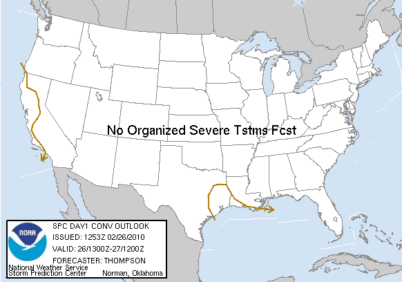
Image

DAY 1 CONVECTIVE OUTLOOK
NWS STORM PREDICTION CENTER NORMAN OK
0653 AM CST FRI FEB 26 2010

VALID 261300Z - 271200Z

...NO SVR TSTM AREAS FORECAST...

...SYNOPSIS...
AN AMPLIFIED FLOW REGIME WILL PERSIST OVER THE CONUS TODAY WITH A
DEEP CLOSED LOW CENTERED OVER LONG ISLAND...A SRN STREAM SHORTWAVE
TROUGH MOVING FROM TX/OK TO THE NRN GULF OF MEXICO...AND A STRONG
SHORTWAVE TROUGH MOVING EWD FROM THE ERN PAC TO CA BY EARLY
SATURDAY. THE TX TROUGH WILL BE PRECEDED BY THE NWD RETURN OF A
MODIFYING CONTINENTAL POLAR AIR MASS FROM THE WRN GULF OF MEXICO TO
SE TX...BENEATH CONDITIONALLY UNSTABLE MIDLEVEL LAPSE RATES. THE
NET RESULT WILL BE THE DEVELOPMENT OF WEAK SURFACE-BASED INSTABILITY
ACROSS SE TX BY ABOUT MIDDAY...WHICH WILL SUPPORT THE POTENTIAL FOR
A FEW THUNDERSTORMS ALONG THE PATH OF A WEAK SURFACE WAVE MOVING
SEWD FROM N CENTRAL TX TO THE NW GULF COAST. SOME SMALL HAIL COULD
OCCUR WITH THE STRONGER STORMS GIVEN THE COLD MIDLEVEL TEMPERATURES
/-24 C AT 500 MB/...BUT THE THREAT FOR 1 INCH DIAMETER OR GREATER
HAIL APPEARS TOO SMALL TO WARRANT THE INTRODUCTION OF A 5% SEVERE
HAIL PROBABILITY AREA.

SATELLITE IMAGERY REVEALS A SWATH OF CUMULUS CONVECTION WITH THE
MIDLEVEL THERMAL TROUGH NEAR 130 W...AND OCEANIC LIGHTNING DATA HAVE
CONFIRMED THE PRESENCE OF A FEW THUNDERSTORMS. THIS AREA OF
INSTABILITY IS EXPECTED TO REACH THE NRN CA COAST LATER THIS
AFTERNOON...AND SPREAD SWD ACROSS THE CENTRAL/SRN CA COAST BY EARLY
SATURDAY AS THE MIDLEVEL TROUGH BEGINS TO MOVE INLAND.

..THOMPSON.. 02/26/2010
Carla/Alicia/Jerry(In The Eye)/Michelle/Charley/Ivan/Dennis/Katrina/Rita/Wilma/Humberto/Ike/Harvey

Member: National Weather Association
Facebook.com/Weather Infinity
Twitter @WeatherInfinity
User avatar
wxman57
Global Moderator
Global Moderator
Posts: 2621
Joined: Thu Feb 04, 2010 5:34 am
Location: Southwest Houston (Westbury)
Contact:

In my never-ending quest for warm weather, I plotted a couple of meteograms from the latest GFS that go out to March 14th. Unfortunately, there is still no light at the end of the tunnel. Not ONE forecast of 70+ temps through mid March!

Image

Image
redneckweather
Posts: 1023
Joined: Mon Feb 08, 2010 7:29 pm
Location: Montgomery, Texas
Contact:

Man wxman, that REALLY blows!!
User avatar
kayci
Posts: 358
Joined: Thu Feb 04, 2010 10:30 am
Location: Alvin
Contact:

PsuWNMatt wrote:What an interesting weather day here in central PA...Near blizzard conditions (at times) have been occurring for the past 18 hours and it looks like that might continue here for the next couple hours...I was walking back from town last night and in the 4 years I have been here, I've never seen such brutal conditions before...Just doing things like taking out the garbage is a tough task out in this!...But of course for all weathernerds out there, it's a lot of fun too... :mrgreen:
Matt, you're such a diehard! :mrgreen:
User avatar
srainhoutx
Site Admin
Site Admin
Posts: 19616
Joined: Tue Feb 02, 2010 2:32 pm
Location: Maggie Valley, NC
Contact:

Ed Mahmoud wrote:Re: SPC Outlook, line to the West of showers might, if we're all very good, have a random flash/rumble.
Getting those rumbles now in NW Harris County. ;)
Carla/Alicia/Jerry(In The Eye)/Michelle/Charley/Ivan/Dennis/Katrina/Rita/Wilma/Humberto/Ike/Harvey

Member: National Weather Association
Facebook.com/Weather Infinity
Twitter @WeatherInfinity
redneckweather
Posts: 1023
Joined: Mon Feb 08, 2010 7:29 pm
Location: Montgomery, Texas
Contact:

As I said in Ed's funderstorm thread, we had some good hail here at my office off of Rayford/Sawdust and I-45. It was coming down good! The thunder was nice to hear also....not sure when the last time I heard thunder was? :shock: :D
User avatar
wxdata
Site Admin
Site Admin
Posts: 1059
Joined: Wed Feb 03, 2010 3:04 pm
Location: Houston, TX
Contact:

At least on vis satellite, it's a 'purdy' looking upper system. Classic comma shape...
User avatar
wxdata
Site Admin
Site Admin
Posts: 1059
Joined: Wed Feb 03, 2010 3:04 pm
Location: Houston, TX
Contact:

Report: Alief- marble size hail
Post Reply
  • Information