
Euro has also went from STx/NMex to near Florida in the span of a few runs. Typical flip flopping with the longer range and needs to become more consistent and should do so as we shorten the range.
This is still a week or so from being a potential threat to any of the Gulf states.
Hurricane Alex. 40 Miles NNE of La Pesca. 100 MPH/948MB
-
srainhoutx

- Site Admin

- Posts: 19616
- Joined: Tue Feb 02, 2010 2:32 pm
- Location: Maggie Valley, NC
- Contact:
Carla/Alicia/Jerry(In The Eye)/Michelle/Charley/Ivan/Dennis/Katrina/Rita/Wilma/Humberto/Ike/Harvey
Member: National Weather Association
Facebook.com/Weather Infinity
Twitter @WeatherInfinity
Member: National Weather Association
Facebook.com/Weather Infinity
Twitter @WeatherInfinity
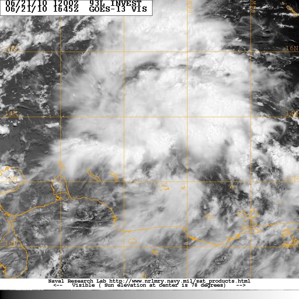
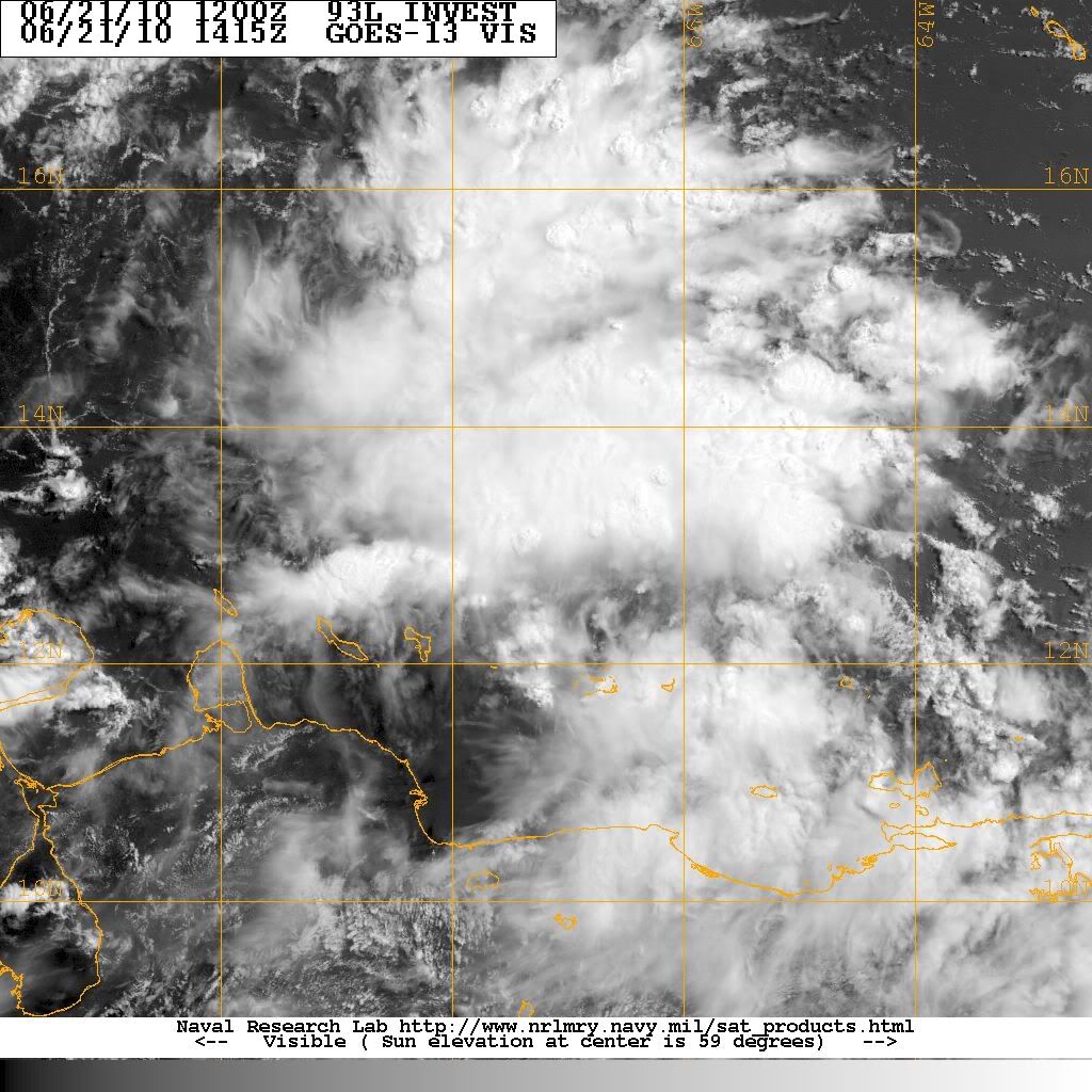
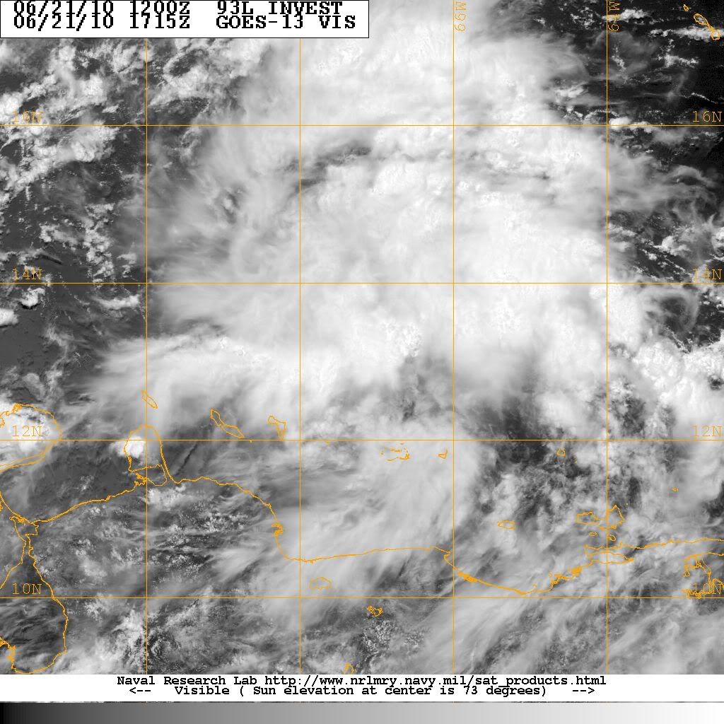
Is it me, and I promise I am not trying to be a smartie pants here as I am still learning, or does 93L seem to be looking a little more healthy this afternoon?
My name is Nicole and I love weather!!
~~~~~~~~~~~~~~~~~~~~~~~~~~~~~~~~~~~~~~~~~~~~~~~~~~~~~~~~~~~~~~~~~~~~~~~~~~~~~~~~~~~~~~~~~~~~~~~~
Alicia, Allison, Rita, Ike
~~~~~~~~~~~~~~~~~~~~~~~~~~~~~~~~~~~~~~~~~~~~~~~~~~~~~~~~~~~~~~~~~~~~~~~~~~~~~~~~~~~~~~~~~~~~~~~~
Alicia, Allison, Rita, Ike

In a hurry so I don't have time to mince words:
Favorable shear - check
Ridge overhead forecasted to build W with the system - check
Favorbale SSTs - check
Favorable MJO - check
Large Moisture Envelope - check
Model support for development - check (forget the GFS for now)
I think we will see Alex out of this. Not buying the latest Euro track. This one needs to be watched...we have late summer SSTs in the GOM with a ridge to the north.
Early HWRF run @ 42 hrs -

-
Hardcoreweather
2pm
000
ABNT20 KNHC 211748
TWOAT
TROPICAL WEATHER OUTLOOK
NWS TPC/NATIONAL HURRICANE CENTER MIAMI FL
200 PM EDT MON JUN 21 2010
FOR THE NORTH ATLANTIC...CARIBBEAN SEA AND THE GULF OF MEXICO...
#5
A LARGE AREA OF SHOWERS AND THUNDERSTORMS OVER THE EASTERN CARIBBEAN
SEA IS ASSOCIATED WITH A STRONG TROPICAL WAVE THAT IS MOVING
WESTWARD AT 10 TO 15 MPH. ALTHOUGH THERE IS NO EVIDENCE OF A
SURFACE CIRCULATION...THIS SYSTEM IS SHOWING SOME SIGNS OF
ORGANIZATION AND ENVIRONMENTAL CONDITIONS APPEAR CONDUCIVE FOR
GRADUAL DEVELOPMENT DURING THE NEXT COUPLE OF DAYS. THIS WAVE
COULD PRODUCE LOCALLY HEAVY RAINFALL AND GUSTY WINDS OVER PORTIONS
OF NORTHERN VENEZUELA...THE NETHERLANDS ANTILLES...PUERTO
RICO...THE DOMINICAN REPUBLIC...AND HAITI OVER THE NEXT DAY OR SO.
THERE IS A MEDIUM CHANCE...30 PERCENT...OF THIS SYSTEM BECOMING A
TROPICAL CYCLONE DURING THE NEXT 48 HOURS.
ELSEWHERE...TROPICAL CYCLONE FORMATION IS NOT EXPECTED DURING THE
NEXT 48 HOURS.
$$
FORECASTER BLAKE

30% now...
-
srainhoutx
- Site Admin
- Posts: 19616
- Joined: Tue Feb 02, 2010 2:32 pm
- Location: Maggie Valley, NC
- Contact:
Hardcoreweather wrote:2pm
000
ABNT20 KNHC 211748
TWOAT
TROPICAL WEATHER OUTLOOK
NWS TPC/NATIONAL HURRICANE CENTER MIAMI FL
200 PM EDT MON JUN 21 2010
FOR THE NORTH ATLANTIC...CARIBBEAN SEA AND THE GULF OF MEXICO...
#5
A LARGE AREA OF SHOWERS AND THUNDERSTORMS OVER THE EASTERN CARIBBEAN
SEA IS ASSOCIATED WITH A STRONG TROPICAL WAVE THAT IS MOVING
WESTWARD AT 10 TO 15 MPH. ALTHOUGH THERE IS NO EVIDENCE OF A
SURFACE CIRCULATION...THIS SYSTEM IS SHOWING SOME SIGNS OF
ORGANIZATION AND ENVIRONMENTAL CONDITIONS APPEAR CONDUCIVE FOR
GRADUAL DEVELOPMENT DURING THE NEXT COUPLE OF DAYS. THIS WAVE
COULD PRODUCE LOCALLY HEAVY RAINFALL AND GUSTY WINDS OVER PORTIONS
OF NORTHERN VENEZUELA...THE NETHERLANDS ANTILLES...PUERTO
RICO...THE DOMINICAN REPUBLIC...AND HAITI OVER THE NEXT DAY OR SO.
THERE IS A MEDIUM CHANCE...30 PERCENT...OF THIS SYSTEM BECOMING A
TROPICAL CYCLONE DURING THE NEXT 48 HOURS.
ELSEWHERE...TROPICAL CYCLONE FORMATION IS NOT EXPECTED DURING THE
NEXT 48 HOURS.
$$
FORECASTER BLAKE
Carla/Alicia/Jerry(In The Eye)/Michelle/Charley/Ivan/Dennis/Katrina/Rita/Wilma/Humberto/Ike/Harvey
Member: National Weather Association
Facebook.com/Weather Infinity
Twitter @WeatherInfinity
Member: National Weather Association
Facebook.com/Weather Infinity
Twitter @WeatherInfinity
-
srainhoutx
- Site Admin
- Posts: 19616
- Joined: Tue Feb 02, 2010 2:32 pm
- Location: Maggie Valley, NC
- Contact:
Decent development in a few hours...
Carla/Alicia/Jerry(In The Eye)/Michelle/Charley/Ivan/Dennis/Katrina/Rita/Wilma/Humberto/Ike/Harvey
Member: National Weather Association
Facebook.com/Weather Infinity
Twitter @WeatherInfinity
Member: National Weather Association
Facebook.com/Weather Infinity
Twitter @WeatherInfinity
Jeff Lindner's update:
Strong tropical wave over the east-central Caribbean Sea is becoming better organized.
Visible satellite images show numerous developing convective clusters, but as of yet no well defined surface circulation. Moist envelop surrounds this system of interest and strong shear in the Caribbean will be weakening over the next 24-48 hours allowing the development of favorable upper air conditions. NHC has risen the threat of TX development in the next 48 hours into the 30-50%. Conditions only get better aloft and at the surface as the system heads for the western Caribbean Sea by the end of the week.
Intensity guidance is very aggressive with this system, with SHIPS taking it well into a hurricane by days 4 and 5 which is very aggressive for a June tropical system…but it has happened before. Gulf water temperatures are now running in the low to mid 80’s and are more than warm enough to support a tropical cyclone. Models are forecasting the development of an anticyclone aloft over the system as it enters the Gulf, so conditions do look ripe for intensification.
Model guidance remains inconsistent on the potential track with various possibilities playing out. CMC and EURO are strongest and show a weakness in the southern US ridge over the central Gulf states allowing the system to gradually recurve into the eastern Gulf coast. The GFS is still showing no development at all…which is really strange for this model along with the UKMET. The NOGAPS shows a weaker system sliding WNW into the western Gulf of Mexico. Way too early to tell either way with anything.
Recon aircraft is tasked to investigate if needed on Wednesday
-
Andrew
- Site Admin
- Posts: 3440
- Joined: Wed Feb 03, 2010 9:46 pm
- Location: North-West Houston
- Contact:
Looks like we are finally getting some action. A link I use a whole lot and I suggest others bookmark really shows the wave getting "Stronger" in the last day or so:

For Your Infinite Source For All Things Weather Visit Our Facebook
-
srainhoutx
- Site Admin
- Posts: 19616
- Joined: Tue Feb 02, 2010 2:32 pm
- Location: Maggie Valley, NC
- Contact:

Carla/Alicia/Jerry(In The Eye)/Michelle/Charley/Ivan/Dennis/Katrina/Rita/Wilma/Humberto/Ike/Harvey
Member: National Weather Association
Facebook.com/Weather Infinity
Twitter @WeatherInfinity
Member: National Weather Association
Facebook.com/Weather Infinity
Twitter @WeatherInfinity
-
srainhoutx
- Site Admin
- Posts: 19616
- Joined: Tue Feb 02, 2010 2:32 pm
- Location: Maggie Valley, NC
- Contact:
12Z EC has a much weaker low nearing the TX Coast around July 1st.
Carla/Alicia/Jerry(In The Eye)/Michelle/Charley/Ivan/Dennis/Katrina/Rita/Wilma/Humberto/Ike/Harvey
Member: National Weather Association
Facebook.com/Weather Infinity
Twitter @WeatherInfinity
Member: National Weather Association
Facebook.com/Weather Infinity
Twitter @WeatherInfinity
lolScott747 wrote:Euro has also went from STx/NMex to near Florida in the span of a few runs. Typical flip flopping with the longer range and needs to become more consistent and should do so as we shorten the range.
This is still a week or so from being a potential threat to any of the Gulf states.
flip flop du jour

-
srainhoutx
- Site Admin
- Posts: 19616
- Joined: Tue Feb 02, 2010 2:32 pm
- Location: Maggie Valley, NC
- Contact:
Almost had to expect that run Strat. Getting the 'feel' of tropical season though. I suspect that there will be few late nights ahead for the night crew... 
Carla/Alicia/Jerry(In The Eye)/Michelle/Charley/Ivan/Dennis/Katrina/Rita/Wilma/Humberto/Ike/Harvey
Member: National Weather Association
Facebook.com/Weather Infinity
Twitter @WeatherInfinity
Member: National Weather Association
Facebook.com/Weather Infinity
Twitter @WeatherInfinity
Well you know how much faith I put into the Euro and do a somewhat decent job in being able to balance out the moves in the longer range. If you put me up against the wall I'd venture to guess that it will start to become more consistent in track with something towards the WGOM, STx/NMex as we move forward.srainhoutx wrote:Almost had to expect that run Strat. Getting the 'feel' of tropical season though. I suspect that there will be few late nights ahead for the night crew...
-
srainhoutx
- Site Admin
- Posts: 19616
- Joined: Tue Feb 02, 2010 2:32 pm
- Location: Maggie Valley, NC
- Contact:
Code: Select all
290
WHXX01 KWBC 211846
CHGHUR
TROPICAL CYCLONE GUIDANCE MESSAGE
NWS TPC/NATIONAL HURRICANE CENTER MIAMI FL
1846 UTC MON JUN 21 2010

DISCLAIMER...NUMERICAL MODELS ARE SUBJECT TO LARGE ERRORS.
PLEASE REFER TO NHC OFFICIAL FORECASTS FOR TROPICAL CYCLONE
AND SUBTROPICAL CYCLONE INFORMATION.

ATLANTIC OBJECTIVE AIDS FOR

DISTURBANCE INVEST (AL932010) 20100621 1800 UTC

        ...00 HRS...   ...12 HRS...   ...24 HRS. ..   ...36 HRS...
        100621  1800   100622  0600   100622  1800   100623  0600

         LAT    LON     LAT    LON     LAT    LON     LAT    LON
BAMS    13.5N  67.8W   14.2N  69.9W   15.1N  72.2W   15.9N  74.3W
BAMD    13.5N  67.8W   14.4N  70.0W   15.4N  72.2W   16.1N  74.2W
BAMM    13.5N  67.8W   14.2N  70.0W   15.1N  72.3W   15.8N  74.5W
LBAR    13.5N  67.8W   14.5N  69.8W   15.7N  72.2W   16.6N  74.5W
SHIP        25KTS          32KTS          41KTS          51KTS
DSHP        25KTS          32KTS          41KTS          51KTS

        ...48 HRS...   ...72 HRS...   ...96 HRS. ..   ..120 HRS...
        100623  1800   100624  1800   100625  1800   100626  1800

         LAT    LON     LAT    LON     LAT    LON     LAT    LON
BAMS    16.6N  76.6W   17.8N  80.6W   19.1N  84.0W   20.3N  87.0W
BAMD    16.6N  76.0W   17.3N  79.3W   18.1N  82.2W   18.9N  84.6W
BAMM    16.4N  76.6W   17.3N  80.2W   18.3N  83.3W   19.2N  86.0W
LBAR    17.4N  76.6W   18.3N  80.5W   20.3N  83.7W   22.4N  85.7W
SHIP        61KTS          76KTS          89KTS         100KTS
DSHP        61KTS          76KTS          89KTS         100KTS

         ...INITIAL CONDITIONS...
LATCUR =  13.5N LONCUR =  67.8W DIRCUR = 290DEG SPDCUR =  11KT
LATM12 =  12.8N LONM12 =  65.9W DIRM12 = 285DEG SPDM12 =  12KT
LATM24 =  12.3N LONM24 =  63.2W
WNDCUR =   25KT RMAXWD =   30NM WNDM12 =   25KT
CENPRS = 1010MB OUTPRS = 1011MB OUTRAD =  120NM SDEPTH =   S
RD34NE =    0NM RD34SE =    0NM RD34SW =    0NM RD34NW =   0NM
Carla/Alicia/Jerry(In The Eye)/Michelle/Charley/Ivan/Dennis/Katrina/Rita/Wilma/Humberto/Ike/Harvey
Member: National Weather Association
Facebook.com/Weather Infinity
Twitter @WeatherInfinity
Member: National Weather Association
Facebook.com/Weather Infinity
Twitter @WeatherInfinity


-
sleetstorm
- Posts: 651
- Joined: Thu Feb 04, 2010 12:33 pm
- Contact:
93L is only 225 miles away from the city of Punta Gallinas in northeastern Colombia, South America and only 77 miles away from the island of Curacao in the southern Carribean Sea. I acquired all of this from Stormpulse/Hurricane. I never knew that KHOU 11 News had that type of software or pragram. It certainly does look rather interesting. I am going to explore more into it.