
August 2020:


-
MontgomeryCoWx

- Posts: 2623
- Joined: Wed Dec 14, 2011 4:31 pm
- Location: Weimar, TX
- Contact:
WORST
MONTH
OF
THE
YEAR
MONTH
OF
THE
YEAR
Team #NeverSummer
Will be busy with the tropics.

We may be leaving town, traveling in a bubble.
-
srainhoutx

- Site Admin

- Posts: 19686
- Joined: Tue Feb 02, 2010 2:32 pm
- Location: Maggie Valley, NC
- Contact:
While it is in the longer range of the ECMWF, the disturbance that exited Africa yesterday may be worth watching as it traverses the MDR.
- Attachments
-
Carla/Alicia/Jerry(In The Eye)/Michelle/Charley/Ivan/Dennis/Katrina/Rita/Wilma/Humberto/Ike/Harvey
Member: National Weather Association
Facebook.com/Weather Infinity
Twitter @WeatherInfinity
Member: National Weather Association
Facebook.com/Weather Infinity
Twitter @WeatherInfinity
-
srainhoutx
- Site Admin
- Posts: 19686
- Joined: Tue Feb 02, 2010 2:32 pm
- Location: Maggie Valley, NC
- Contact:
The disturbance that the ECMWF is suggesting may pose a threat to the NW Caribbean/Gulf the first week of August has been designated 92L near the Cape Verde Islands. Thought I would post the information here since July will be over soon and early August would be any potential threat to the Gulf.
Carla/Alicia/Jerry(In The Eye)/Michelle/Charley/Ivan/Dennis/Katrina/Rita/Wilma/Humberto/Ike/Harvey
Member: National Weather Association
Facebook.com/Weather Infinity
Twitter @WeatherInfinity
Member: National Weather Association
Facebook.com/Weather Infinity
Twitter @WeatherInfinity
All aboard the wave train. Choo Choo!
The last official major hurricane to make a direct strike on the Houston/Galveston area was Category 3 Hurricane Alicia on Thursday, August 18, 1983 at 2:00 am, with maximum sustained winds of 115mph and a minimum central air pressure 962mb. Just food for thought for our weather forum.
The NHC just increased the odds of development for 92L up to 50%.
-
Texaspirate11

- Posts: 1278
- Joined: Tue Dec 31, 2013 12:24 am
- Contact:
Big batch of SAL coming off Africa too
Just because you're disabled, you don't have to be a victim
Be Weather Aware & Prepared!
Barbara Jordan Winner in Media
Disability Integration Consultant
Be Weather Aware & Prepared!
Barbara Jordan Winner in Media
Disability Integration Consultant
-
Stormlover2020
- Posts: 546
- Joined: Mon Jun 01, 2020 6:04 pm
- Contact:
Ike was a major hurricane I don’t care what anybody says


Forecast model of Invest 92L.
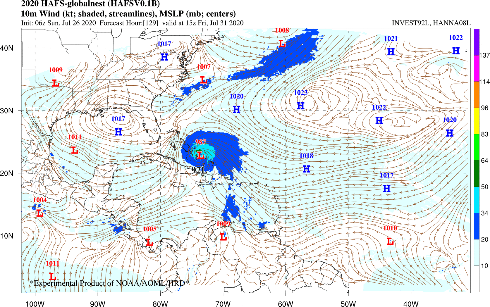
Hurricane Analysis and Forecast System (HAFS) has Invest 92L/Isaias as a hurricane over Bahamas this Saturday. Subject to change.
Hurricane Analysis and Forecast System (HAFS)
https://www.weather.gov/media/sti/nggps ... ragada.pdf
Hurricane Analysis and Forecast System (HAFS) has Invest 92L/Isaias as a hurricane over Bahamas this Saturday. Subject to change.
Hurricane Analysis and Forecast System (HAFS)
https://www.weather.gov/media/sti/nggps ... ragada.pdf
GFS Ensemble for Invest 92L.

Looks to be an East Coast hurricane at this time. Always subject to change.
Looks to be an East Coast hurricane at this time. Always subject to change.
-
srainhoutx
- Site Admin
- Posts: 19686
- Joined: Tue Feb 02, 2010 2:32 pm
- Location: Maggie Valley, NC
- Contact:
92L will likely we a slow developer and probably will not slow down it's rapid Westerly motion until mid/late this week as it begins its approach to the Eastern Caribbean. Careful with the various computer schemes including the ensembles beyond 3 to 5 days. I suspect they will not an idea what might happen until reconnaissance missions from the AF and possibly a G-IV high altitude mission give additional data to those model solutions.
Carla/Alicia/Jerry(In The Eye)/Michelle/Charley/Ivan/Dennis/Katrina/Rita/Wilma/Humberto/Ike/Harvey
Member: National Weather Association
Facebook.com/Weather Infinity
Twitter @WeatherInfinity
Member: National Weather Association
Facebook.com/Weather Infinity
Twitter @WeatherInfinity
Models tend to recurve systems out to sea at first and then adjust back west with time. Don’t let your guard down with 92L because it’s way too early for models to know where it’ll go. Ridges and troughs constantly change, especially past 3 days.
-
Texaspirate11
- Posts: 1278
- Joined: Tue Dec 31, 2013 12:24 am
- Contact:
I'm liking the gfs and I never like the gfs
I'm really hoping for a recurve and ots
I'm really hoping for a recurve and ots
Just because you're disabled, you don't have to be a victim
Be Weather Aware & Prepared!
Barbara Jordan Winner in Media
Disability Integration Consultant
Be Weather Aware & Prepared!
Barbara Jordan Winner in Media
Disability Integration Consultant
I am not letting my guards down yet.
The latest Euro takes this as far west as the central Gulf before turning north. Models shifting further south and west it seems.
-
Stormlover2020
- Posts: 546
- Joined: Mon Jun 01, 2020 6:04 pm
- Contact:
Let’s see how strong that trough is
quite the storn - no chance of getting back to sleep now though, might as well put the coffee on !
https://map.blitzortung.org/#7.14/29.712/-95.461
https://www.harriscountyfws.org/

https://map.blitzortung.org/#7.14/29.712/-95.461
https://www.harriscountyfws.org/
-
- Information
-
Who is online
Users browsing this forum: Ahrefs [Bot], Bing [Bot], Stratton20 and 25 guests