Day 2 Convective Outlook
NWS Storm Prediction Center Norman OK
0108 AM CDT Wed Mar 17 2021
Valid 181200Z - 191200Z
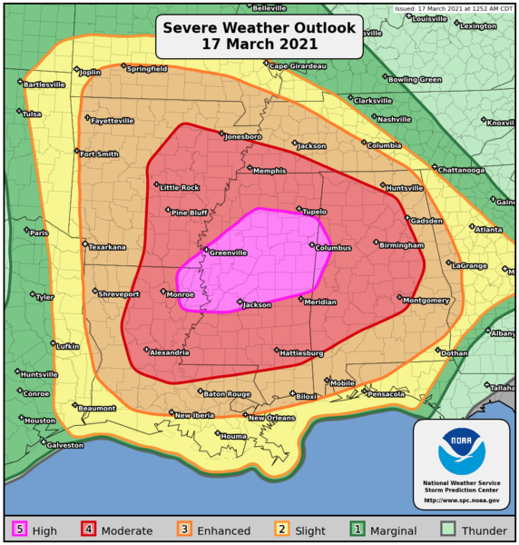
...THERE IS A MODERATE RISK OF SEVERE THUNDERSTORMS FROM CENTRAL AND
EASTERN GEORGIA NORTHEASTWARD ACROSS PARTS OF CENTRAL AND EASTERN
NORTH CAROLINA...
...SUMMARY...
A widespread/substantial severe weather event is expected to
continue into Thursday from southern Virginia southward into
Florida, and westward into portions of eastern Kentucky/eastern
Tennessee. Along with potential for widespread damaging winds and
hail, several tornadoes -- a few of them likely to be strong -- are
anticipated.
...Synopsis...
An upper low initially forecast over the Ozarks area is expected to
shift steadily eastward through the period, reaching the Mid South
by evening and then crossing the Appalachians and evolving into a
more open wave overnight. Meanwhile in the west, an eastern Pacific
upper low/trough should approach the West Coast overnight.
At the surface, a low initially progged over the southern Illinois
area will cross the Ohio Valley through the day. By evening, the
low should reside in the central Appalachians area, and then is
expected to elongate across the Mid Atlantic region overnight as
weak offshore low development commences. A cold front trailing from
the low -- bisecting the Mid South and extending south to the
western Florida Panhandle -- should clear the crest of the
Appalachians during the early evening, before continuing eastward to
move off the East Coast overnight. Meanwhile, a remnant damming
front will shift quickly northward as a warm front across the
Atlantic Coast states, allowing a warm sector to spread northward
into Virginia ahead of the advancing low.
...Eastern KY/TN east to the Chesapeake Bay, and south to FL...
Showers and thunderstorms are forecast to be ongoing in an elongated
zone of warm advection from Missouri east across the Ohio Valley
states and into the Mid Atlantic region, and more significantly --
from eastern Tennessee and possibly eastern Kentucky, southward
across western Georgia, southeastern Alabama, and the Florida
Panhandle. Ongoing/all-hazards severe risk is expected to accompany
the convection -- primarily across the northern/western Georgia
vicinity.
With time, continued northward moistening/theta-e advection ahead of
the approaching system will result in a broad warm sector east of
the Appalachian crest, and secondarily -- across parts of eastern
Kentucky and southern Ohio into West Virginia/western Virginia.
Though heating may be tempered into the afternoon in many areas due
to downstream cloud debris from ongoing convection, around 1000 J/kg
mixed-layer CAPE should become widespread across the warm sector.
The increasingly moist/unstable environment will support a
continuation of the ongoing storms within a loose band ahead of the
cold front, which will spread across Georgia and the Carolinas, and
eventually southern Virginia, with some potential for
isolated/cellular development ahead of this convective band. Cells
may also develop in the wake of an initial convective band northward
into western North Carolina, while storms also develop into the
afternoon west of the mountains into southern Ohio/western
Kentucky/west Virginia. The storms west of the mountains will
likely become locally severe, with hail and damaging winds the
primary risk, though a tornado or two would be possible.
Farther south and east -- into eastern Georgia and the Carolinas,
and spreading north into parts of southern Virginia, very strong
flow aloft, veering -- and increasing substantially in magnitude
with height through the lower troposphere -- will result in shear
quite favorable for supercells. Along with hail potential, the more
substantial risk will be from widespread damaging winds, as well as
tornadoes -- including possibility for a few strong/significant
tornadoes during the afternoon and into the early evening. Threat
will gradually taper from west to east, as the system shifts
eastward and the cold front eventually moves offshore.
..Goss.. 03/17/2021