Page 9 of 18

Re: April 2021

Posted: Thu Apr 22, 2021 9:54 pm
by don
The HRRR looks pretty active for tomorrow. And the 0z NAM also.

Re: April 2021

Posted: Thu Apr 22, 2021 10:45 pm
by Cpv17
I’m hoping we can get some of these storms to actually form south of I-10 for a change. It’s so aggravating and annoying for us in the southern counties.

Re: April 2021

Posted: Fri Apr 23, 2021 7:55 am
by Cpv17
Man, what a horrible trend on the models since yesterday when I said they looked good. Geez :roll:

Re: April 2021

Posted: Fri Apr 23, 2021 8:27 am
by don
HRRR is still looking very active this afternoon.

Re: April 2021

Posted: Fri Apr 23, 2021 8:31 am
by don
image3.png
Day 1 Convective Outlook
NWS Storm Prediction Center Norman OK
1251 AM CDT Fri Apr 23 2021

Valid 231200Z - 241200Z

...THERE IS AN ENHANCED RISK OF SEVERE THUNDERSTORMS LATE THIS
AFTERNOON INTO TONIGHT ACROSS PARTS OF EASTERN TEXAS...MUCH OF
CENTRAL AND NORTHERN LOUISIANA...ADJACENT SOUTHERN ARKANSAS AND
SOUTHWESTERN MISSISSIPPI...

...SUMMARY...
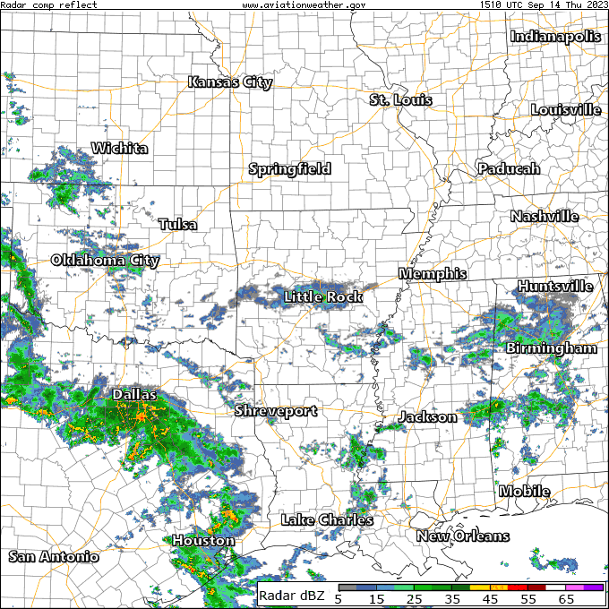
Severe thunderstorms are possible today across the southern Great
Plains into the lower Mississippi Valley. This may include the
evolution of large, organized cluster of storms across the Piney
Woods vicinity into the lower Mississippi Valley by this evening,
which could produce a swath or two of damaging wind gusts and
perhaps a couple of tornadoes.

...Synopsis...
Deep mid-level troughing, with a developing embedded low, has
emerged from the Arctic latitudes and is forecast to become
entrenched across much of interior Canada during this period,
downstream of a blocking mid-level high which has become centered
across Alaska. To the southeast of the low, a similar preceding
perturbation, and associated deep surface cyclone, appear likely to
gradually turn northward across and north of the Canadian Maritimes.


As this lead system gradually loses influence on the Northeast,
models indicate that a belt of westerlies emanating from the
mid-latitude Pacific will continue to become a more prominent
influence across much of the remainder of the United States. This
regime includes a significant short wave trough now turning eastward
across parts of the Southwest and northwestern Mexico, as it comes
in phase with a belt of westerlies emanating from the subtropical
eastern Pacific. It appears that this feature will accelerate
east-northeastward, across southern portions of the Great Plains
into the lower Mississippi Valley by late tonight.

In lower levels, while another intrusion of cold air surges south of
the Canadian/U.S. border, to the east of the northern Rockies,
through much of the northern Great Plains, potentially cold air
associated with a preceding intrusion will, at least initially, be
slow to lose influence across much of the Southeast into lower
Mississippi Valley. However, a substantive return flow of moisture
is ongoing off the western Gulf of Mexico into the southern Great
Plains, and this will tend to spread east-northeastward in advance
of the impulse emerging from the Southwest/Mexican Plateau, and
broad surface troughing developing eastward across the southern
Great Plains.

...Southern Great Plains through the central Gulf states...
Beneath steep mid-level lapse rates associated with elevated
mixed-layer air, daytime heating is expected to contribute to
moderately large mixed-layer CAPE, in at least a narrow corridor
along a developing dryline from the eastern Texas Panhandle into the
Hill Country vicinity by this afternoon. Low clouds may slow
destabilization within a developing wedge of returning
boundary-layer moisture across central/southeast Texas into the
north central Gulf coast vicinity, while trajectories emanating from
surface ridging slow boundary-layer moistening across and northeast
of the lower Mississippi Valley.

Further complicating warm sector boundary-layer destabilization,
various model output suggests that thunderstorm activity may
initiate by midday east of the dryline, across parts of central
Texas into the Texas coastal plain. It appears that this may occur
in response to forcing associated with a subtropical perturbation
preceding the primary short wave trough, aided by lower/mid
tropospheric warm advection, and guidance indicates a steady
increase in thunderstorm development while spreading
east-northeastward through the afternoon.

Re: April 2021

Posted: Fri Apr 23, 2021 8:47 am
by txbear
I had a hunch based on jasons2k's post yesterday on SigTor probabilities that SPC might upgrade a portion to an enhanced risk (full disclosure - I said moderate not realizing i had mistakenly skipped the "enhanced" level).

HRRR sounding for my general area looks a bit better as far as not teetering on the edge of capped situation. Appears to really have some potential for surfaced based convection to get going, but I'm curious how much things will be limited with the low level cloud deck in place.

ETA: Definitely a day to keep tabs on things.

Re: April 2021

Posted: Fri Apr 23, 2021 8:57 am
by Cromagnum
Great. More "North of I-10" crap.

Re: April 2021

Posted: Fri Apr 23, 2021 9:02 am
by jasons2k
Cromagnum wrote: Fri Apr 23, 2021 8:57 am Great. More "North of I-10" crap.
It won’t be long before the summer season is here and the convection is more focused along the coast (or just offshore). Then we’ll be the ones complaining about the heat and praying for a sea breeze shower.

Re: April 2021

Posted: Fri Apr 23, 2021 9:13 am
by Cromagnum
jasons2k wrote: Fri Apr 23, 2021 9:02 am
Cromagnum wrote: Fri Apr 23, 2021 8:57 am Great. More "North of I-10" crap.
It won’t be long before the summer season is here and the convection is more focused along the coast (or just offshore). Then we’ll be the ones complaining about the heat and praying for a sea breeze shower.
I know. I've drug my sprinkler out several times this spring already. My ground is cracked everywhere.

Re: April 2021

Posted: Fri Apr 23, 2021 9:33 am
by Cromagnum
Judging by how the clouds are hanging low and cruising very quickly off towards the north with high humidity, I'm sure someone is going to have a rough day somewhere though.

Re: April 2021

Posted: Fri Apr 23, 2021 9:51 am
by DoctorMu
jasons2k wrote: Fri Apr 23, 2021 9:02 am
Cromagnum wrote: Fri Apr 23, 2021 8:57 am Great. More "North of I-10" crap.
It won’t be long before the summer season is here and the convection is more focused along the coast (or just offshore). Then we’ll be the ones complaining about the heat and praying for a sea breeze shower.
lol Yeah, I was going to say wait until summer. Sometime in June the spigot turns off and we never see the sea breeze north of Brenham or Navasota.

Re: April 2021

Posted: Fri Apr 23, 2021 9:54 am
by jasons2k
Went to bed with a dew point of 60f.
Dew point is now 69f and steadily rising.

Re: April 2021

Posted: Fri Apr 23, 2021 10:28 am
by Cpv17
Cromagnum wrote: Fri Apr 23, 2021 8:57 am Great. More "North of I-10" crap.
I’m right there with you. This looks to be a nonevent south of I-10. Frustrating. I’m still holding on to some hope though. Some models still show we could get around half an inch so I’ll gladly take that if we can get it.

Re: April 2021

Posted: Fri Apr 23, 2021 10:42 am
by Kingwood36
Irs suppose to clear out by tonight and leave the wknd nice right?

Re: April 2021

Posted: Fri Apr 23, 2021 11:00 am
by don
Yes, the weekend will be nice after today.I think it's going to be a pretty active day around here.The impulse triggering showers right now around the coastal bend region will be the trigger for thunderstorms later this afternoon.Im also a little concerned with street flooding issues in urban areas if we start to see storms redeveloping over the same areas like the HRRR is showing.

Re: April 2021

Posted: Fri Apr 23, 2021 11:01 am
by jasons2k
Yes, should be a nice weekend.

I’m not sure what model The Weather Channel’s ‘Storm Radar’ app runs from but it shows things blowing-up about 2pm in the warm sector with a squall line forming to the NW into the evening.

Re: April 2021

Posted: Fri Apr 23, 2021 11:53 am
by srainhoutx
Watch coming for portions of Central and N Central Texas in an hour or two...

Re: April 2021

Posted: Fri Apr 23, 2021 1:04 pm
by DoctorMu
don wrote: Fri Apr 23, 2021 11:00 am Yes, the weekend will be nice after today.I think it's going to be a pretty active day around here.The impulse triggering showers right now around the coastal bend region will be the trigger for thunderstorms later this afternoon.Im also a little concerned with street flooding issues in urban areas if we start to see storms redeveloping over the same areas like the HRRR is showing.
Pulses seem North and West of Hwy 59 mostly.

We could end up in the gap between the streamer showers and broken dry line. Would not be surprised to see 0.5 inches or less. We'll see.

Re: April 2021

Posted: Fri Apr 23, 2021 1:06 pm
by unome

Re: April 2021

Posted: Fri Apr 23, 2021 1:07 pm
by DoctorMu
The severe t-storm watch is just west of us and most of the HGX area. Hoping for soaking. Expecting a near bust.

Message: NOAA-NWS-ALERTS-TX12619B18117C.SevereThunderstormWatch.12619B24D510TX.WNSWOU8.65b40533d93ad5e14db070063903e710 from w-nws.webmaster@noaa.gov
Sent: 12:35 CDT on 04-23-2021
Effective: 12:40 CDT on 04-23-2021
Expires: 20:00 CDT on 04-23-2021
Event: Severe Thunderstorm Watch
Alert:
SEVERE THUNDERSTORM WATCH 98 IS IN EFFECT UNTIL 800 PM CDT
FOR THE FOLLOWING LOCATIONS
TX

. TEXAS COUNTIES INCLUDED ARE
ANDERSON ARCHER BASTROP
BELL BLANCO BOSQUE
BURNET CALDWELL CLAY
COLLIN COMAL COMANCHE
COOKE CORYELL DALLAS
DELTA DENTON EASTLAND
ELLIS ERATH FALLS
FANNIN FAYETTE FREESTONE
GRAYSON HAMILTON HAYS
HENDERSON HILL HOOD
HOPKINS HUNT JACK
JOHNSON KAUFMAN LAMAR
LAMPASAS LEE LEON
LIMESTONE MCLENNAN MILAM
MILLS MONTAGUE NAVARRO
PALO PINTO PARKER RAINS
ROBERTSON ROCKWALL SOMERVELL
STEPHENS TARRANT TRAVIS
VAN ZANDT WICHITA WILLIAMSON
WISE YOUNG