May 2021:

General Weather Discussions and Analysis
869MB
Posts: 156
Joined: Fri Oct 30, 2015 8:44 am
Location: Katy, TX
Contact:

Image

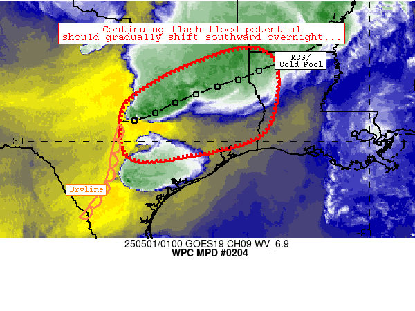
Mesoscale Precipitation Discussion 0204
NWS Weather Prediction Center College Park MD
911 PM EDT Tue May 18 2021

Areas affected...Parts of Southern and Southeast Texas

Concerning...Heavy rainfall...Flash flooding likely

Valid 190110Z - 190700Z

Summary...The risk of flash flooding will increase during the
evening over portions of southern and southeastern Texas this
evening...with the risk persisting beyond 07Z.

Discussion...There has been an increasing signal in the high
resolution convective-allowing models for flash flooding this
evening and into the overnight hours given persistent southeast
flow interacting with a quasi-stationary northeast-southwest
oriented boundary. 00Z soundings showed southerly low-level flow
of 20 to 30 kts drawing in an airmass with precipitable water
values in excess of 1.75 inches...resulting a moisture flux
convergence max along an outflow boundary/effective boundary over
southern and southeast Texas. MLCAPE values south of the effective
boundary had reached nearly 4000 J per kg during the time of
maximum heating during the afternoon...which allowed rainfall
rates to peak at 4 inches per hour in Fayette county Texas.
Because low level flow expected to increase to 30 kts or greater
at 850 mb during the evening, isolated rainfall rates of 2 to 3
inches per hour are still expected despite the loss of solar
heating.

The HRRR began consistently showing widespread areal-average
amounts of 2 to 4 inches...with isolated maximum values of 8+
inches...as early as its 18/20Z run. The experimental version of
the HRRR looked to be aligned with the NAM solution in placement
of its 2 and 3 inch per hour values, but those ideas were
verifying too far north and west as of early this evening.

Given some overlap between areas which received heavy rainfall in
the past 24 hour and the current placement shown by the guidance,
thinking is that flash flooding will become likely during the
evening and that the risk will extend beyond 07Z.

Bann

ATTN...WFO...CRP...EWX...FWD...HGX...LCH...SHV...

ATTN...RFC...WGRFC...NWC...
User avatar
tireman4
Global Moderator
Global Moderator
Posts: 4496
Joined: Wed Feb 03, 2010 9:24 pm
Location: Humble, Texas
Contact:

Do I see a bow echo?
Cromagnum
Posts: 2632
Joined: Thu Feb 03, 2011 10:42 pm
Contact:

tireman4 wrote: Tue May 18, 2021 9:21 pm Do I see a bow echo?
Bow echo = worse storm front but over sooner wouldn't it?
Stratton20
Posts: 4250
Joined: Tue Feb 09, 2021 11:35 pm
Location: College Station, Texas
Contact:

I dont think its a Bow Echo, tornado warning issued for my area though, flooding is the main threat
Cromagnum
Posts: 2632
Joined: Thu Feb 03, 2011 10:42 pm
Contact:

Tornado in Katy
User avatar
don
Posts: 2628
Joined: Wed Feb 03, 2010 3:33 pm
Location: Heights
Contact:

Tornado Warning
TXC157-201-473-190245-
/O.NEW.KHGX.TO.W.0014.210519T0212Z-210519T0245Z/

BULLETIN - EAS ACTIVATION REQUESTED
Tornado Warning
National Weather Service Houston/Galveston TX
912 PM CDT Tue May 18 2021

The National Weather Service in League City has issued a

* Tornado Warning for...
Northwestern Fort Bend County in southeastern Texas...
Southeastern Waller County in southeastern Texas...
West central Harris County in southeastern Texas...

* Until 945 PM CDT.

* At 912 PM CDT, a severe thunderstorm capable of producing a tornado
was located over Brookshire, moving east at 30 mph.

HAZARD...Tornado and quarter size hail.

SOURCE...Radar indicated rotation.

IMPACT...Flying debris will be dangerous to those caught without
shelter. Mobile homes will be damaged or destroyed.
Damage to roofs, windows, and vehicles will occur. Tree
damage is likely.

* This dangerous storm will be near...
Fulshear around 915 PM CDT.
Katy around 925 PM CDT.
Cinco Ranch around 935 PM CDT.
Eldridge / West Oaks, Addicks Park Ten and Spring Branch West
around 945 PM CDT.

Other locations impacted by this tornadic thunderstorm include
Addicks and Memorial.

PRECAUTIONARY/PREPAREDNESS ACTIONS...

TAKE COVER NOW! Move to a basement or an interior room on the lowest
floor of a sturdy building. Avoid windows. If you are outdoors, in a
mobile home, or in a vehicle, move to the closest substantial shelter
and protect yourself from flying debris.

Tornadoes are extremely difficult to see and confirm at night. Do not
wait to see or hear the tornado. TAKE COVER NOW!

Torrential rainfall is occurring with this storm, and may lead to
flash flooding. Do not drive your vehicle through flooded roadways.
Stratton20
Posts: 4250
Joined: Tue Feb 09, 2021 11:35 pm
Location: College Station, Texas
Contact:

Im right in the heart of this tornado warning in katy and I can see the storm getting closer, winds have picked up, lightning is bad
davidiowx
Posts: 1063
Joined: Thu Jan 23, 2014 2:39 pm
Location: Richmond, TX
Contact:

It’s about to get real here.. several radar indicated tornadoes as well. Doesn’t mean they are on the ground but winds are getting sideways and fierce lighting all around.
JDsGN
Posts: 128
Joined: Tue May 23, 2017 10:25 pm
Location: Cypress TX
Contact:

Haha my future cast has this just suddenly falling apart and heading north. I hardly ever look at it but it was pretty funny to see. Things are about to get going here in Cypress. Hope all are safe.
Stratton20
Posts: 4250
Joined: Tue Feb 09, 2021 11:35 pm
Location: College Station, Texas
Contact:

I have never ever witnessed rain falling this hard, blinding rain with heavy winds and thubder here in katy
bikerack
Posts: 37
Joined: Tue Jun 01, 2010 8:35 am
Location: Kingwood (front), TX
Contact:

My brother and SIL are in Pecan Grove and are getting nailed right now. They are in the hallway with their kids and said the wind is getting LOUD. They can also hear hail...
User avatar
don
Posts: 2628
Joined: Wed Feb 03, 2010 3:33 pm
Location: Heights
Contact:

In addition to the flash flood threat there is a wind damage threat currently ongoing right now in metro Houston.
User avatar
don
Posts: 2628
Joined: Wed Feb 03, 2010 3:33 pm
Location: Heights
Contact:

hegx.png
hegx.png (13.73 KiB) Viewed 2476 times
Flash flood warning and Tornado warning issued for metro Houston.

BULLETIN - EAS ACTIVATION REQUESTED
Flash Flood Warning
National Weather Service Houston/Galveston TX
943 PM CDT Tue May 18 2021

The National Weather Service in League City has issued a

* Flash Flood Warning for...
Southeastern Austin County in southeastern Texas...
Northern Brazoria County in southeastern Texas...
Fort Bend County in southeastern Texas...
Western Galveston County in southeastern Texas...
Harris County in southeastern Texas...
Southern Montgomery County in southeastern Texas...
Eastern Waller County in southeastern Texas...
Northeastern Wharton County in southeastern Texas...

* Until 1245 AM CDT.

* At 943 PM CDT, Doppler radar indicated thunderstorms producing
heavy rain across the warned area. Between 1 and 3 inches of rain
have fallen. Flash flooding is ongoing or expected to begin
shortly. Brookshire Creek at US Highway 90 reported 2.00 inches of
rain in 30 minutes.

HAZARD...Flash flooding caused by thunderstorms.

SOURCE...Doppler radar.

IMPACT...Flooding of small creeks and streams, urban areas,
highways, streets and underpasses as well as other
drainage and low lying areas.

* Some locations that will experience flash flooding include...
Pasadena, Pearland, southwestern League City, Sugar Land,
northwestern Baytown, Missouri City, southern Conroe, Friendswood,
Deer Park, Rosenberg, Alvin, Stafford, South Houston, Bellaire,
Humble, West University Place, Katy, Richmond, Galena Park and
Tomball.

Additional rainfall amounts of 1 to 3 inches are possible in the
warned area.

PRECAUTIONARY/PREPAREDNESS ACTIONS...

Turn around, don`t drown when encountering flooded roads. Most flood
deaths occur in vehicles.

Be especially cautious at night when it is harder to recognize the
dangers of flooding.

Excessive runoff from heavy rainfall will cause flooding of small
creeks and streams, urban areas, highways, streets and underpasses
as well as other drainage areas and low lying spots.

A Flash Flood Warning means that flooding is imminent or occurring.
If you are in the warned area move to higher ground immediately.
Residents living along streams and creeks should take immediate
precautions to protect life and property.


Severe Weather Statement
National Weather Service Houston/Galveston TX
930 PM CDT Tue May 18 2021

TXC157-201-473-190245-
/O.CON.KHGX.TO.W.0014.000000T0000Z-210519T0245Z/
Fort Bend TX-Waller TX-Harris TX-
930 PM CDT Tue May 18 2021

...A TORNADO WARNING REMAINS IN EFFECT UNTIL 945 PM CDT FOR NORTH
CENTRAL FORT BEND...SOUTHEASTERN WALLER AND WEST CENTRAL HARRIS
COUNTIES...

At 930 PM CDT, a severe thunderstorm capable of producing a tornado
was located over Katy, moving east at 30 mph.

HAZARD...Tornado and quarter size hail.

SOURCE...Radar indicated rotation.

IMPACT...Flying debris will be dangerous to those caught without
shelter. Mobile homes will be damaged or destroyed. Damage
to roofs, windows, and vehicles will occur. Tree damage is
likely.

This dangerous storm will be near...
Eldridge / West Oaks around 945 PM CDT.
Addicks Park Ten around 950 PM CDT.
Spring Branch West around 955 PM CDT.

Other locations impacted by this tornadic thunderstorm include
Addicks and Memorial.

PRECAUTIONARY/PREPAREDNESS ACTIONS...

TAKE COVER NOW! Move to a basement or an interior room on the lowest
floor of a sturdy building. Avoid windows. If you are outdoors, in a
mobile home, or in a vehicle, move to the closest substantial shelter
and protect yourself from flying debris.

Tornadoes are extremely difficult to see and confirm at night. Do not
wait to see or hear the tornado. TAKE COVER NOW!

Torrential rainfall is occurring with this storm, and may lead to
flash flooding. Do not drive your vehicle through flooded roadways.

&&

Last edited by don on Tue May 18, 2021 10:03 pm, edited 1 time in total.
User avatar
jasons2k
Posts: 5406
Joined: Thu Feb 04, 2010 12:54 pm
Location: Imperial Oaks
Contact:

Headed home from baseball - almost got the whole game in.
Quite a lightning show!
Cromagnum
Posts: 2632
Joined: Thu Feb 03, 2011 10:42 pm
Contact:

So what happens after this beast of a line blows through? Is this the one that is suppose to stall or is it the next one?
Stratton20
Posts: 4250
Joined: Tue Feb 09, 2021 11:35 pm
Location: College Station, Texas
Contact:

Could be the next one, but their are still questions about the next round
User avatar
djmike
Posts: 1704
Joined: Fri Jan 07, 2011 12:19 pm
Location: BEAUMONT, TX
Contact:

Thought this one was supposed to stall out over us. Looks to be moving at a good clip which is good. Unfortunately the rain rates are so high it would be like as if the storm did stall. We will see. My luck iIt’ll come to a complete stop over Beaumont.
Mike
Beaumont, TX
(IH-10 & College Street)
User avatar
Rip76
Posts: 1790
Joined: Mon Feb 15, 2010 12:38 am
Location: The Woodlands
Contact:

In Sugarland tonight, storming like mad right now.
Cromagnum
Posts: 2632
Joined: Thu Feb 03, 2011 10:42 pm
Contact:

Hitting us in Rosharon any minute now.
User avatar
jasons2k
Posts: 5406
Joined: Thu Feb 04, 2010 12:54 pm
Location: Imperial Oaks
Contact:

The line is moving along up here.
Looks like training will setup towards the Southwest tonight down towards Matagorda, Bay City, Port Lavaca areas.
Post Reply
  • Information
  • Who is online

    Users browsing this forum: Ahrefs [Bot], Bing [Bot] and 106 guests