
May 2021:
The 12z Euro looks interesting towards the end of its run with another big trough in the sw. It shows about 3-5” for this coming week. Back on Tuesday it was showing 6 to as much as 20” across the area so it’s nowhere near as wet as what it was showing a few runs back but I have a feeling quite a few of us could still pick up some hefty totals similar to that next week.
My wife washed her car for the first time in a long time. Apologies to everyone for the flood this is going to cause.
-
srainhoutx

- Site Admin

- Posts: 19616
- Joined: Tue Feb 02, 2010 2:32 pm
- Location: Maggie Valley, NC
- Contact:
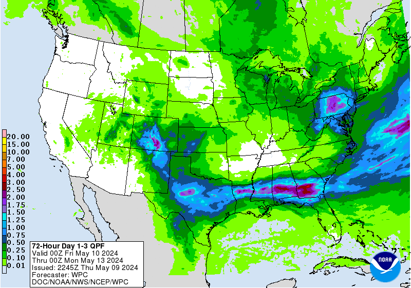
Updated 7 Day Quantitative Precipitation Forecast from the Weather Prediction Center...
- Attachments
-
Carla/Alicia/Jerry(In The Eye)/Michelle/Charley/Ivan/Dennis/Katrina/Rita/Wilma/Humberto/Ike/Harvey
Member: National Weather Association
Facebook.com/Weather Infinity
Twitter @WeatherInfinity
Member: National Weather Association
Facebook.com/Weather Infinity
Twitter @WeatherInfinity
-
Iceresistance
- Posts: 577
- Joined: Fri Apr 30, 2021 11:48 pm
- Location: Tecumseh, OK
- Contact:
Oklahoma is also going to be soaked!srainhoutx wrote: ↑Fri May 14, 2021 6:22 pm Updated 7 Day Quantitative Precipitation Forecast from the Weather Prediction Center...
Not sure how good the FV3 model is but it looks concerning on Sunday.
-
Iceresistance
- Posts: 577
- Joined: Fri Apr 30, 2021 11:48 pm
- Location: Tecumseh, OK
- Contact:
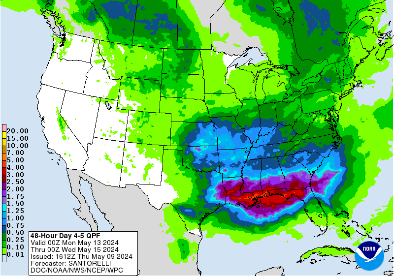
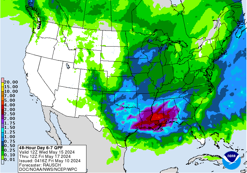
I wish the new WPC page had the 4-5 day & 6-7 day QPF graphics like the legacy page does. It makes it easier to see possibilities & mentally assign a reality factor if it's mostly further out in the forecast periodsrainhoutx wrote: ↑Fri May 14, 2021 6:22 pm Updated 7 Day Quantitative Precipitation Forecast from the Weather Prediction Center...
I do like that they have precip filled in for all 7 days of the fronts/pressures graphics https://www.wpc.ncep.noaa.gov/#page=frt, now they need to do it for the 7-day loop

Overnight GFS and EURO are now showing significant rainfall amounts across southeast Texas with the brunt of the rainfall happening Tuesday/Wednesday. As multiple Mesoscale convection systems slow down over the area as the disturbances bump into the southeast ridge to our east. Stay weather aware as street flooding is possible as early as tomorrow when the first wave moves through the area.And bayou and river flooding may become an issue by mid week.
- Attachments
-
-

Doesn’t look like any pools will get dug next week.
We are number 6 in line, and hoping for dry weather for a change
We are number 6 in line, and hoping for dry weather for a change
Again, I’m not too sure how reliable this model is but it’s going crazy with the rainfall in the next 48 hours:

The HRRR is also is showing training tomorrow in localize spots.As a disturbance moves over the area from south central Texas.Definitely need to watch for street flooding issues tomorrow if the training pans out.12Z GFS is still showing significant rainfall totals.
- Attachments
-
The fv-3 was an upgraded version of the gfs based on the gfdl grid and released back in 2019.
The latest upgrade of the gfs that was released back in March is basically an upgrade of the fv-3.
12z EURO showing some localized spots getting up to 15 inches.
- Attachments
-
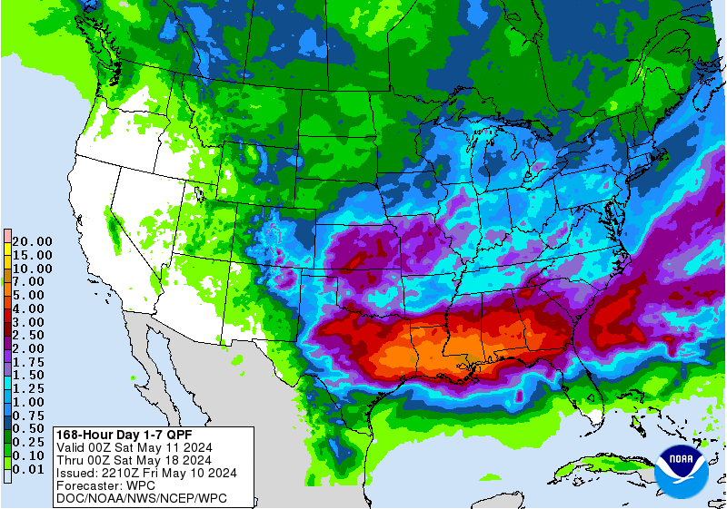
Exact rainfall amounts and locations are nearly impossible to forecast accurately this far out.What to take from the models right now is that the the setup is there for significant rainfall totals possibly over a widespread area,but it will be a couple of more days still before the forecasts is fine tuned more.
Goodness, that’s a huge swath of land that rain will cover. The whole eastern two thirds or 3/4 of the state and much of Oklahoma basically. Big ticket event, no doubt.
Last edited by Cpv17 on Sat May 15, 2021 3:15 pm, edited 1 time in total.
Will any of the weather currently east of San Antonio and around Victoria make it here today/tonight?
It doesn’t look like it. Short range models have that falling apart within the next few hours. Maybe some areas in the far western part of the viewing area could see a little bit out of it.
Looks like the WPC has finally bought in, sorta:
Geez. My dang yard looks like a lake