Page 9 of 39
Re: May 2021
Posted: Sat May 15, 2021 11:34 am
by don
The HRRR is also is showing training tomorrow in localize spots.As a disturbance moves over the area from south central Texas.Definitely need to watch for street flooding issues tomorrow if the training pans out.12Z GFS is still showing significant rainfall totals.
Re: May 2021
Posted: Sat May 15, 2021 11:50 am
by Scott747
Cpv17 wrote: ↑Sat May 15, 2021 10:57 am
Again, I’m not too sure how reliable this model is but it’s going crazy with the rainfall in the next 48 hours:
The fv-3 was an upgraded version of the gfs based on the gfdl grid and released back in 2019.
The latest upgrade of the gfs that was released back in March is basically an upgrade of the fv-3.
Re: May 2021
Posted: Sat May 15, 2021 2:07 pm
by don
12z EURO showing some localized spots getting up to 15 inches.
Re: May 2021
Posted: Sat May 15, 2021 2:28 pm
by Dls2010r
Where?
Re: May 2021
Posted: Sat May 15, 2021 2:50 pm
by don
Exact rainfall amounts and locations are nearly impossible to forecast accurately this far out.What to take from the models right now is that the the setup is there for significant rainfall totals possibly over a widespread area,but it will be a couple of more days still before the forecasts is fine tuned more.
Re: May 2021
Posted: Sat May 15, 2021 2:59 pm
by Cpv17
Goodness, that’s a huge swath of land that rain will cover. The whole eastern two thirds or 3/4 of the state and much of Oklahoma basically. Big ticket event, no doubt.
Re: May 2021
Posted: Sat May 15, 2021 3:14 pm
by oleander
Will any of the weather currently east of San Antonio and around Victoria make it here today/tonight?
Re: May 2021
Posted: Sat May 15, 2021 3:18 pm
by Cpv17
oleander wrote: ↑Sat May 15, 2021 3:14 pm
Will any of the weather currently east of San Antonio and around Victoria make it here today/tonight?
It doesn’t look like it. Short range models have that falling apart within the next few hours. Maybe some areas in the far western part of the viewing area could see a little bit out of it.
Re: May 2021
Posted: Sat May 15, 2021 3:25 pm
by Cpv17
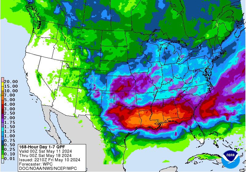
Looks like the WPC has finally bought in, sorta:
Re: May 2021
Posted: Sat May 15, 2021 3:30 pm
by Dls2010r
Geez. My dang yard looks like a lake
Re: May 2021
Posted: Sat May 15, 2021 5:29 pm
by Iceresistance
Cpv17 wrote: ↑Sat May 15, 2021 3:25 pm
Looks like the WPC has finally bought in, sorta:
Well, I'm expecting more than Y'all down there & have a higher risk of Flooding, but the good news is that I live on top of a hill . . .
Re: May 2021
Posted: Sat May 15, 2021 6:44 pm
by tireman4
This will be an interesting set of days coming up. We need the rain, but it always feast or famine ( to quote Jason) around these parts. Stay weather aware.
Re: May 2021
Posted: Sat May 15, 2021 7:26 pm
by Kingwood36
When is the rain going to start?
Re: May 2021
Posted: Sat May 15, 2021 8:40 pm
by Cpv17
Kingwood36 wrote: ↑Sat May 15, 2021 7:26 pm
When is the rain going to start?
If I had to guess I’d say around lunchtime or slightly before it.
Re: May 2021
Posted: Sat May 15, 2021 9:54 pm
by Texashawk
Surprising there’s not more chatter around here what with potential flooding rains and a possible tropical system later next week...
Re: May 2021
Posted: Sat May 15, 2021 10:30 pm
by Iceresistance
Texashawk wrote: ↑Sat May 15, 2021 9:54 pm
Surprising there’s not more chatter around here what with potential flooding rains and a possible tropical system later next week...
Model consistency issues with the potential Tropical System & I'm thinking that everyone is getting Flood-Ready . . .
Re: May 2021
Posted: Sat May 15, 2021 10:45 pm
by DoctorMu
Out of town. TG we left the sprinklers off.
XUS64 KHGX 160226
AFDHGX
Area Forecast Discussion
National Weather Service Houston/Galveston TX
926 PM CDT Sat May 15 2021
.SHORT TERM [Tonight through Sunday]...
Lead shortwave has pushed into the Coastal Bend this evening and
rains over the far west and southwestern areas have tapered off.
Have lowered rain chances across the area through 5 am then as the
next wave approaches have focused shower/thunderstorm chances
with the arrival of the wave. Models have broadly different
solutions on the timing and location of storms. So based on where
the greater lift with the upper speed max should begin over the
areas to the west/southwest and so have come to the conclusion
that the storms should focus over the southern areas. If they
initiate later then they would probably track into the northern
areas. Cloud cover should be extensive and temperatures only
rising into the upper 70s to around 80.
45
&&
.AVIATION [00Z TAF Issuance]...
Moisture axis feeding through the area should keep MVFR ceilings
over the southwestern areas this evening eventually expanding up
into the CLL and eventually LBX/SGR area between 12-15z. Then
after 15z expecting showers to be common and transitioning into
TSRA after 17z especially for areas CXO-IAH southward through the
afternoon. VCTS persisting in the afternoon with PROB30 TSRA.
After the round of storms in the afternoon will have lighter more
variable winds in the wake then CIGS will likely collapse into IFR
after 00z...especially over the northern half of the area.
45
&&
.PREV DISCUSSION /Issued 328 PM CDT Sat May 15 2021/...
.LONG TERM [Monday Through Saturday]...
As we head into next week, our concerns remain focused around the
possibility of multiple periods of showers and storms that may
produce locally heavy rain. The synoptic pattern will indeed be
favorable for such an outcome. Persistent southerly flow at the
surface will provide a steady stream of low-level moisture to the
region, with global models remaining in fairly good agreement in
their indication of PW values remaining in the 1.75-2.0 inch range
by Monday. Aloft, the continued but slow eastward propagation of
a closed low will place its center of circulation over the Four
Corners region by Monday afternoon. While Monday`s rainfall
chances are lower behind the departure of the upper shortwave on
Sunday, we continue to anticipate scattered precipitation coverage
throughout the day as the aforementioned upper low approaches.
Rainfall chances begin to increase on Tuesday as the development
of a split jet pattern at 300mb will place SE TX in a highly
favorable region for upper-level divergence. As a series of
disturbances embedded within the now negatively tilted upper
trough/low traverse the area, rounds of widespread showers and
storms will begin to develop by late Tuesday with some rainfall
potentially becoming heavy at times. Of greater concern is
Wednesday, by which the advance of the upper low and increasing
strength/more favorable positioning of the upper jet streaks will
enhance upper divergence even more. With abundant moisture in
place throughout the full column and model soundings indicating a
clear "skinny CAPE" profile typically seen during heavy rain
events, we are becoming more confident in the potential for
locally heavy rainfall and the potential for flash flooding on
Wednesday and into Thursday. While it`s still too late to
determine exact rainfall amounts given the ever-changing "bulls-
eyes" in each global deterministic solution, it`s increasingly
likely that most of SE TX will receive several inches of rain
during this time. As a result I have increased PoPs for most
locations to around 80%.
As upper-level support weakens by the end of the week with the
departure of the aforementioned upper low, the possibility of
heavy rainfall will consequently diminish as well. That being
said, the approach of a second upper trough to our west and a
persistent onshore flow pattern at the surface will continue to
favor active weather as we approach next weekend.
Cady
Re: May 2021
Posted: Sat May 15, 2021 11:34 pm
by don
0Z GFS qpf amounts....
Re: May 2021
Posted: Sat May 15, 2021 11:55 pm
by Cpv17
don wrote: ↑Sat May 15, 2021 11:34 pm
0Z GFS qpf amounts....
That’s nuts.
Re: May 2021
Posted: Sun May 16, 2021 12:26 am
by Texashawk
Cpv17 wrote: ↑Sat May 15, 2021 11:55 pm
don wrote: ↑Sat May 15, 2021 11:34 pm
0Z GFS qpf amounts....
That’s nuts.
Quite a few people said it was nuts around September of 2017, too...

I’d keep my antenna up on this one, folks.
 I’d keep my antenna up on this one, folks.