

Its just a comparison of the run to run swings in the GFS. (Last nights run, and this morning's model run)
June 2021:
Man, some of these ensemble members look pretty interesting. And just to think 24 hours ago at this time I was kinda writing this system off. This was a good reminder for me that you can’t do that especially when it’s still 5+ days out.
So the top pic is last night and the bottom pic is today?
12Z intensity models. I would like to see the global models get onboard though, before i buy into these intensity models showing a strong tropical storm.
- Attachments
-
unless you've been living in a cave the past 5 years, you know good and well this will be a TS at some point, so just skip the 20%, now40%, oh, now 60%...just skip to the chase already lol
I noticed that also, 6z GFS has a strong storm or category 1 into southwest Louisiana. Will be interesting to see if the trend continues.

Morning update from Jeff:
Surface observations indicate that a broad trough of low pressure has developed in the SW Gulf of Mexico. IR satellite images indicate scattered showers and thunderstorms are associated with this broad feature, but lack any sort of sustained organization and at this time there is no defined area of surface low pressure. 92L is interacting with several other features including an areas of disturbed weather over the eastern Pacific Ocean south of Mexico and the larger background circulation of the Central American Gyre (CAG).
The surface trough over the Bay of Campeche is broad and it will take time for surface low pressure to form. Global model guidance suggests that by the middle to end of this week, a more defined surface low pressure center will form out of the broad trough. Little movement of 92L is expected as the system remains in weak steering flow through the next 3-4 days.
The ultimate track of 92L will likely be controlled by a large ridge of high pressure over the SW US and a trough along the US east coast and most importantly where the actual low level center forms. The ridge of high pressure over the SW US will try to impart a track more toward the NW while the trough along the US east coast will try to tug the system toward the NE. A general track toward the north is likely by late in the week or next weekend, but is this a track toward TX or areas further east along the US Gulf coast. Upper level winds are forecasted to be somewhat unfavorable for development of a tropical system over the western Gulf of Mexico with 30-40kts of shear and this could result in a heavily eastern weighted system and the potential for center re-locations toward the east in favor of the deeper convective areas. Models are showing a fairly lopsided and elongated system with more of the weather focused east of any surface center and this is important to keep in mind with looking at any specific model guidance or guidance tracks of the actual surface center.
NHC currently indicates a 50% chance of tropical cyclone formation over the next 5 days, with much of this potential beyond 48 hours. There is much uncertainty in the ultimate track of 92L without any sort of defined surface center at this time.
Residents along the US Gulf coast from TX to the FL panhandle should monitor the progress of this system over the next week.
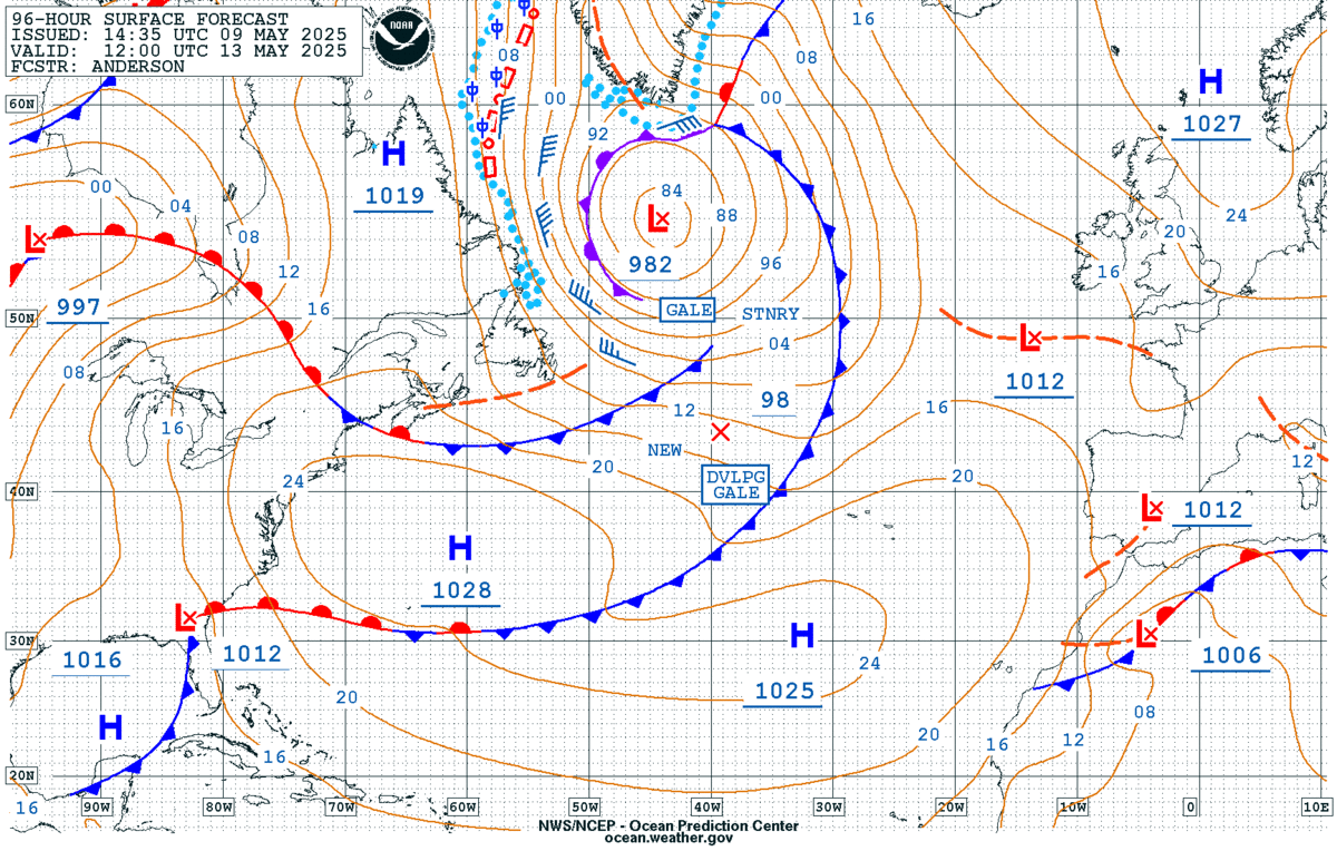
OPC Atlantic 96-hr forecast from https://ocean.weather.gov/Atl_tab.php
surface https://ocean.weather.gov/shtml/A_96hrsfc.gif
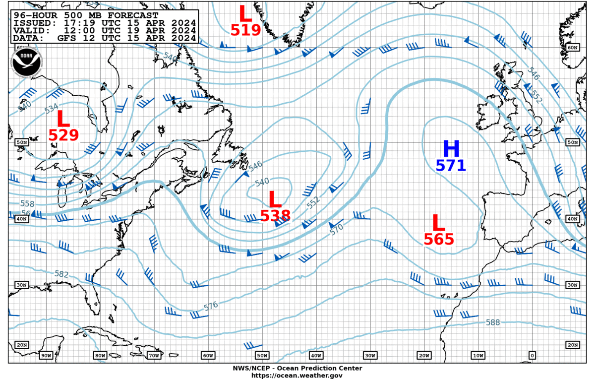
edit to add 500mb, now updated https://ocean.weather.gov/shtml/A_96hr500.gif
surface https://ocean.weather.gov/shtml/A_96hrsfc.gif
edit to add 500mb, now updated https://ocean.weather.gov/shtml/A_96hr500.gif
Last edited by unome on Sun Jun 13, 2021 1:10 pm, edited 1 time in total.
-
Stratton20
- Posts: 4248
- Joined: Tue Feb 09, 2021 11:35 pm
- Location: College Station, Texas
- Contact:
NHC HAS increased development in the next 2 days to 20% says 92L has become slightly more organized, 5 day odds still at 50%
-
TexasBreeze
- Posts: 942
- Joined: Sun Sep 26, 2010 4:46 pm
- Location: NW Houston, TX
- Contact:
I would say for being so far in advance there is fairly good agreement between the models on track!
The rain forecast is basically nill for Houston and a pounding for south central LA.
-
Stratton20
- Posts: 4248
- Joined: Tue Feb 09, 2021 11:35 pm
- Location: College Station, Texas
- Contact:
We better get rain, still plenty of time for the track to change, im sick of this awful heat, we better not be on the dry and hot ainking air side of this
-
Stratton20
- Posts: 4248
- Joined: Tue Feb 09, 2021 11:35 pm
- Location: College Station, Texas
- Contact:
CPv17 I hope this doesnt happen, I really dont want us to be in the frying pan, after living in the Middle East/ Arabian Desert for 2 years, I cant hide my hatred for hot weather


Yup there’s usually one June/July TD or TS that throws SE Texas in the dry side.
Hope for TStorms and showers before Friday.
Hope for TStorms and showers before Friday.
Is it looking like it stays east of the border? I really don't want anymore rain right now.