
June 2021:

Rainfall rates are high, its pouring outside right now. Looks like its at least around 2 inch an hour rates at times.

Stafford is getting hammered.
thankful I finished the last outdoor chore I will probably do for the next week before it started today
https://youtu.be/T5al0HmR4to
still like this rainy stuff better than 90+ & baking sun though, or ashes raining down like years past
stay safe, just be smart peeps
forgot to add:
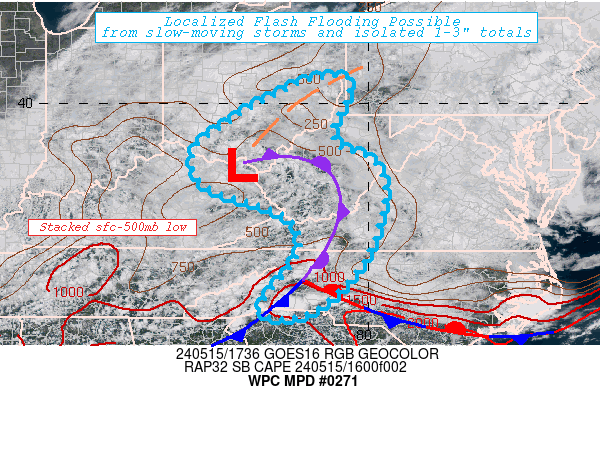
Mesoscale Precipitation Discussion 0271
NWS Weather Prediction Center College Park MD
334 PM EDT Thu Jun 03 2021
Areas affected...TX/LA
Concerning...Heavy rainfall...Flash flooding possible
Valid 031933Z - 040133Z
Summary...An isolated to scattered flash flood risk continues
across portions of south TX. Further east, a localized flash flood
risk may also exist over southeast TX into southwest LA.
Discussion...A convective cluster continues to slowly drift
southward over south central TX this afternoon. Expect continued
convective development along this outflow as it moves into an
environment characterized by ~2000 J/KG of MLCAPE. We are also
seeing some discrete development downstream of this activity over
south TX. Mean flow supports a south to north movement of
cells...however the entire convective cluster is propagating
southward. Thus we are likely to see some cell mergers through the
afternoon hours as convective development continues over south TX.
PWs around 2" and a deep warm cloud layer will continue to support
efficient rainfall in any of the stronger cells. Would continue to
expect localized hourly rainfall of 3". Wet antecedent conditions
and soil moisture running above average across this portion of
south TX, combined with the expected rainfall rates, supports an
isolated to scattered flash flood risk where cell mergers occur
into the evening hours.
Further east over southeast TX and southwest LA, convective cells
are developing along a stationary boundary just inland of the Gulf
Coast. These cells will be slow moving near the boundary, and will
generally pulse up and down quick enough at any one location to
limit the extent of the flash flood risk. However we probably have
just enough deep layer shear to support some multi cell activity,
which may persist/merge enough to locally result in some 2-3"
rainfall totals in an hour or two resulting in isolated flash
flooding here as well.
Chenard
ATTN...WFO...BRO...CRP...EWX...HGX...LCH...
ATTN...RFC...LMRFC...WGRFC...NWC...
https://youtu.be/T5al0HmR4to
still like this rainy stuff better than 90+ & baking sun though, or ashes raining down like years past
stay safe, just be smart peeps
forgot to add:
Mesoscale Precipitation Discussion 0271
NWS Weather Prediction Center College Park MD
334 PM EDT Thu Jun 03 2021
Areas affected...TX/LA
Concerning...Heavy rainfall...Flash flooding possible
Valid 031933Z - 040133Z
Summary...An isolated to scattered flash flood risk continues
across portions of south TX. Further east, a localized flash flood
risk may also exist over southeast TX into southwest LA.
Discussion...A convective cluster continues to slowly drift
southward over south central TX this afternoon. Expect continued
convective development along this outflow as it moves into an
environment characterized by ~2000 J/KG of MLCAPE. We are also
seeing some discrete development downstream of this activity over
south TX. Mean flow supports a south to north movement of
cells...however the entire convective cluster is propagating
southward. Thus we are likely to see some cell mergers through the
afternoon hours as convective development continues over south TX.
PWs around 2" and a deep warm cloud layer will continue to support
efficient rainfall in any of the stronger cells. Would continue to
expect localized hourly rainfall of 3". Wet antecedent conditions
and soil moisture running above average across this portion of
south TX, combined with the expected rainfall rates, supports an
isolated to scattered flash flood risk where cell mergers occur
into the evening hours.
Further east over southeast TX and southwest LA, convective cells
are developing along a stationary boundary just inland of the Gulf
Coast. These cells will be slow moving near the boundary, and will
generally pulse up and down quick enough at any one location to
limit the extent of the flash flood risk. However we probably have
just enough deep layer shear to support some multi cell activity,
which may persist/merge enough to locally result in some 2-3"
rainfall totals in an hour or two resulting in isolated flash
flooding here as well.
Chenard
ATTN...WFO...BRO...CRP...EWX...HGX...LCH...
ATTN...RFC...LMRFC...WGRFC...NWC...
Last edited by unome on Thu Jun 03, 2021 3:11 pm, edited 1 time in total.
-
Stratton20
- Posts: 4248
- Joined: Tue Feb 09, 2021 11:35 pm
- Location: College Station, Texas
- Contact:
Getting hammered in Katy right now
Looks like the WPC has cut back on the totals. Now showing 3-5” with some areas of 5-7”.
We had a brief shower here at my job in Rosenberg. Poured for maybe 5 min that’s it and then we had some light rain for 30 min after that. Didn’t amount to too much. This event so far for me has underperformed but I know that could change quickly.
We had a brief shower here at my job in Rosenberg. Poured for maybe 5 min that’s it and then we had some light rain for 30 min after that. Didn’t amount to too much. This event so far for me has underperformed but I know that could change quickly.
-
Stratton20
- Posts: 4248
- Joined: Tue Feb 09, 2021 11:35 pm
- Location: College Station, Texas
- Contact:
CP17 eh i still think those totals are pretty conservative. Picked up almost 2.5 inches of rain in laty in about 45 minutes
Last night the north side of Katy got a flood. There was a red cell over them for an hour straight.Stratton20 wrote: ↑Thu Jun 03, 2021 4:00 pm CP17 eh i still think those totals are pretty conservative. Picked up almost 2.5 inches of rain in laty in about 45 minutes
Excessive Rainfall Discussion
NWS Weather Prediction Center College Park MD
316 PM EDT Thu Jun 03 2021
Day 2
Valid 12Z Fri Jun 04 2021 - 12Z Sat Jun 05 2021
...THERE IS A SLIGHT RISK OF EXCESSIVE RAINFALL ACROSS SOUTHERN
TEXAS...
21Z Update...Models are still indicating the upper low to linger
over the region bringing ample amounts of moist gulf air into
southern TX. With grounds already sitting at 400 to 600% of normal
and new rainfall totals of 1 to 3 inches with pockets of 3 to 5
inches showing up on some of the Hi-Res solutions coupled with
continued precipitation expected over the days leading up to this
period, have opted to include a Slight Risk area for portions of
southern TX. The Marginal Risk area was extended a bit to
encompass the latest model guidance with variance on placement.
Excessive Rainfall Discussion
NWS Weather Prediction Center College Park MD
317 PM EDT Thu Jun 03 2021
Day 3
Valid 12Z Sat Jun 05 2021 - 12Z Sun Jun 06 2021
...THERE IS A SLIGHT RISK OF EXCESSIVE RAINFALL ACROSS SOUTH
EASTERN TEXAS INTO PORTIONS OF SOUTHWEST LOUISIANA...
21Z Update...The closed low starts to slowly migrate eastward
through this period with ample moisture being pumped in from the
gulf. Models are in better alignment as to placement of the
heavier signals with the coastal areas of south-eastern TX and
southern LA seeing the heaviest amounts and extending offshore.
Consensus is 1 to 3 inches with a handful of models showing 3 to 5
inches right along the coast. FFG for these areas is on the lower
end except for portions of LA, but with the expected rainfall
leading up to this period, expect FFG to be even lower and grounds
to be even more saturated. AHPS does show 150 to 200% along the LA
coast with areas in TX much higher around 200 to 400% of normal
soil saturation. With this being said, have opted to place a
Slight Risk area where the heavier signals are along the coast of
TX and southern LA. The Marginal Risk area that was in place from
the previous issuance was tweaked slightly to account for model
differences.
- Attachments
-
-
Radar is really starting to fill in, as the MCS moving in is enhancing precipitation along the stalled boundary.But the rain cooled air should hopefully keep hourly rainfall rates lower.

-
Stratton20
- Posts: 4248
- Joined: Tue Feb 09, 2021 11:35 pm
- Location: College Station, Texas
- Contact:
Here in katy, picked up about 4-5 inches just in the past 2 hours, roads were flooded pretty badly.
It just fizzled out here. Not much but drizzle. No complaints. Impressive rain cooling of the air, though.
Tornado warned storm near Richwood / Clute
On the way to 3” today in Richmond. There is a hook echo in the cell moving NE out of Lake Jackson area.

Neighbor across the street had their pool dug today. I would not want to be in their shoes right now.
Our dig for next week looks iffy.
Our dig for next week looks iffy.
Constant rain in Friendswood since 3pm.
-
MontgomeryCoWx

- Posts: 2356
- Joined: Wed Dec 14, 2011 4:31 pm
- Location: Weimar, TX
- Contact:
Just made it out to our place south of Weimar. My God our stock pond just went over the banks like it was nothing.
The yard out here looks like it hasn’t been mowed in a month but it’s been two weeks.
If I didn’t have my snake boots I’d be concerned about walking out here. We have Copperheads galore and the occasional cottonmouth.
The yard out here looks like it hasn’t been mowed in a month but it’s been two weeks.
If I didn’t have my snake boots I’d be concerned about walking out here. We have Copperheads galore and the occasional cottonmouth.
Team #NeverSummer