Page 2 of 56
Re: June 2021
Posted: Wed Jun 02, 2021 4:42 pm
by Cpv17
Updated map from the WPC:
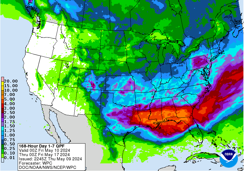
Shows even some isolated pockets of 7-10”.
Re: June 2021
Posted: Wed Jun 02, 2021 4:46 pm
by Stratton20
Might want to put a + after 7-10, definitely thinking some areas might receive even more than that
Re: June 2021
Posted: Wed Jun 02, 2021 4:48 pm
by Cpv17
Stratton20 wrote: ↑Wed Jun 02, 2021 4:46 pm
Might want to put a + after 7-10, definitely thinking some areas might receive even more than that
I agree. Some areas could receive that in one day alone.
Re: June 2021
Posted: Wed Jun 02, 2021 5:01 pm
by Stratton20
Just hope we dont getting any severe storms though, a few days ago we had a big wind storm which caused our basketball goal to fall on my car
Re: June 2021
Posted: Wed Jun 02, 2021 5:16 pm
by MontgomeryCoWx
I had to buy lye to put outside our chicken coop. It was just a muddy, sh***y mess from their droppings. I also ran a splitter off the extension cord and plugged in two "drying fans" on it. It finally dried up today. I'm going to keep them running until our next big storm. I see my area is in that 7-10 range.

Headed back to Colorado County this weekend to our ranch. Our stock pond came out of its banks last week and the buzzards were eating fresh catfish. I may be moving some dirt this weekend to build up the banks.
Despite all of that trouble, I'd still take this weather pattern over the Death Ridge.
Re: June 2021
Posted: Wed Jun 02, 2021 5:50 pm
by Cpv17
MontgomeryCoWx wrote: ↑Wed Jun 02, 2021 5:16 pm
I had to buy lye to put outside our chicken coop. It was just a muddy, sh***y mess from their droppings. I also ran a splitter off the extension cord and plugged in two "drying fans" on it. It finally dried up today. I'm going to keep them running until our next big storm. I see my area is in that 7-10 range.
Headed back to Colorado County this weekend to our ranch. Our stock pond came out of its banks last week and the buzzards were eating fresh catfish. I may be moving some dirt this weekend to build up the banks.
Despite all of that trouble, I'd still take this weather pattern over the Death Ridge.
There’s a pretty big warmup with some ridging showing up the last few days on the 12z Euro. Hope that doesn’t verify.
Re: June 2021
Posted: Wed Jun 02, 2021 5:55 pm
by Stratton20
The Euro shows that on days 8-10 , thank goodness thats far out, I domt want a heat ridge here
Re: June 2021
Posted: Wed Jun 02, 2021 6:01 pm
by Rip76
When thinking about this rain pattern setting up, and there may be a few that don’t like it.
I think of pictures from Bastrop in 2011.
Ugh
Re: June 2021
Posted: Wed Jun 02, 2021 6:28 pm
by MontgomeryCoWx
Rip76 wrote: ↑Wed Jun 02, 2021 6:01 pm
When thinking about this rain pattern setting up, and there may be a few that don’t like it.
I think of pictures from Bastrop in 2011.
Ugh
Yep, a severe drought(s) does so much more long term damage than flooding does.
Re: June 2021
Posted: Wed Jun 02, 2021 6:46 pm
by Stratton20
18z GFS run keeps rain chances going all the way through next Saturday, wow!
Re: June 2021
Posted: Wed Jun 02, 2021 6:51 pm
by Cromagnum
Bad storm near Atascocita and points north.
Re: June 2021
Posted: Wed Jun 02, 2021 7:09 pm
by jasons2k
The line along the sea breeze put the brakes on as soon as it got to my doorstep. Normally I'd be pretty upset about such a turn of events but not this time.
Re: June 2021
Posted: Wed Jun 02, 2021 7:26 pm
by Katdaddy
Time to get the active pattern weather party started. It will be interesting as always to see how storms/storm complexes interact and work over the atmosphere from day to day and who will win the rainfall lottery.
Re: June 2021
Posted: Wed Jun 02, 2021 7:55 pm
by DoctorMu
MontgomeryCoWx wrote: ↑Wed Jun 02, 2021 6:28 pm
Rip76 wrote: ↑Wed Jun 02, 2021 6:01 pm
When thinking about this rain pattern setting up, and there may be a few that don’t like it.
I think of pictures from Bastrop in 2011.
Ugh
Yep, a severe drought(s) does so much more long term damage than flooding does.
Some of our trees never recovered.
Re: June 2021
Posted: Wed Jun 02, 2021 8:06 pm
by ajurcat
I don't know where it came from but we just received 1.25" in the last hour.
Re: June 2021
Posted: Wed Jun 02, 2021 8:42 pm
by don
ajurcat wrote: ↑Wed Jun 02, 2021 8:06 pm
I don't know where it came from but we just received 1.25" in the last hour.
The sea breeze has collided with the stalled frontal boundary.Producing the thunderstorms ongoing right now.
Re: June 2021
Posted: Wed Jun 02, 2021 8:49 pm
by unome
 Mesoscale Precipitation Discussion 0267
NWS Weather Prediction Center College Park MD
928 PM EDT Wed Jun 02 2021
Areas affected...central to southeastern TX
Concerning...Heavy rainfall...Flash flooding possible
Valid 030124Z - 030605Z
Summary...Slow moving and repeating thunderstorms will pose a
flash flood threat to portions of central and southeastern TX
through 06Z. Rainfall rates locally between 2-3 in/hr may lead to
a few pockets of 2-4 inches by 06Z.
Discussion...01Z radar imagery showed a small but slow moving
cluster of convection just north of Houston, located along a
stationary front that draped WNW to ESE across central and
southeastern TX. Ground truth at some nearby stations matched KHGX
rainfall estimates peaking just over 2 in/hr in Harris County.
Upstream radar imagery over central TX showed a southeastward
tracking cluster of thunderstorms moving along the stationary
front to the west of I-35, with additional thunderstorms on either
side of I-35 near Round Rock. The 01Z SPC mesoanalysis showed a
lingering region of MLCAPE between 2000 and 2500 J/kg between
Houston and Austin which will continue to support convection in
the short term.
Radar trends and deeper-layer mean wind forecasts support a
continued east-southeastward movement to the upstream cluster
approaching I-35. Meanwhile, weaker flow near Houston has
supported regeneration of convection to the north of the city with
outflow to the west located over western Montgomery and Harris
counties. Convergence ahead of the advancing cluster west of I-35
and along the surface front should continue to support additional
thunderstorm development over the next 2-4 hours. Rainfall rates
peaking near 2 in/hr may support a few areas with additional
rainfall totals of 2-4 inches through 06Z. Weak 850 mb flow should
allow for eventual propagation of storms off toward the southeast
and a possible end to the flash flood threat beyond 06Z.
Otto
ATTN...WFO...EWX...FWD...HGX...LCH...
ATTN...RFC...WGRFC...NWC...
LAT...LON 30999782 30619586 30529483 30089443 29699475
29419560 29339630 29429735 30099856 30829868
Re: June 2021
Posted: Wed Jun 02, 2021 9:17 pm
by Katdaddy
...Strong Thunderstorm Continues Moving Southeast Just Outside The
Loop...
At 842 PM CDT, Doppler radar was tracking a strong thunderstorm over
Hunterwood, or over Jacinto City, moving southeast at 10 mph.
Pea size hail and winds in excess of 30 mph will be possible with
this storm.
Locations impacted include...
Pasadena, northwestern Baytown, northern Friendswood, Deer Park,
South Houston, Galena Park, Jacinto City, Greater Fifth Ward,
Cloverleaf, Channelview, South Belt / Ellington, Highlands, Barrett,
northern Clear Lake, Second Ward, Greater Hobby Area, Morgan`s Point,
Golfcrest / Bellfort / Reveille, Harrisburg / Manchester and Park
Place.
PRECAUTIONARY/PREPAREDNESS ACTIONS...
Torrential rainfall is also occurring with this storm, and may lead
to localized flooding. Do not drive your vehicle through flooded
roadways.
Re: June 2021
Posted: Wed Jun 02, 2021 9:47 pm
by Rip76
Some killer outflow in Friendswood.
Re: June 2021
Posted: Wed Jun 02, 2021 10:00 pm
by davidiowx
Rip76 wrote: ↑Wed Jun 02, 2021 9:47 pm
Some killer outflow in Friendswood.
Yeah that boundary is crazy. Would not be shocked to see some strong storms/brief heavy rains backside