
September 2021: Hurricane Nicholas
-
Kingwood36
- Posts: 1592
- Joined: Sat Dec 29, 2018 10:29 am
- Location: Freeport
- Contact:
Best guess is part of Connor to Freeport it seems that's where most of the back in forth is going
Heavy cell coming through Spring now.
Starting to get that shape to it. Would not be surprised to wake up to a cane headed our way.
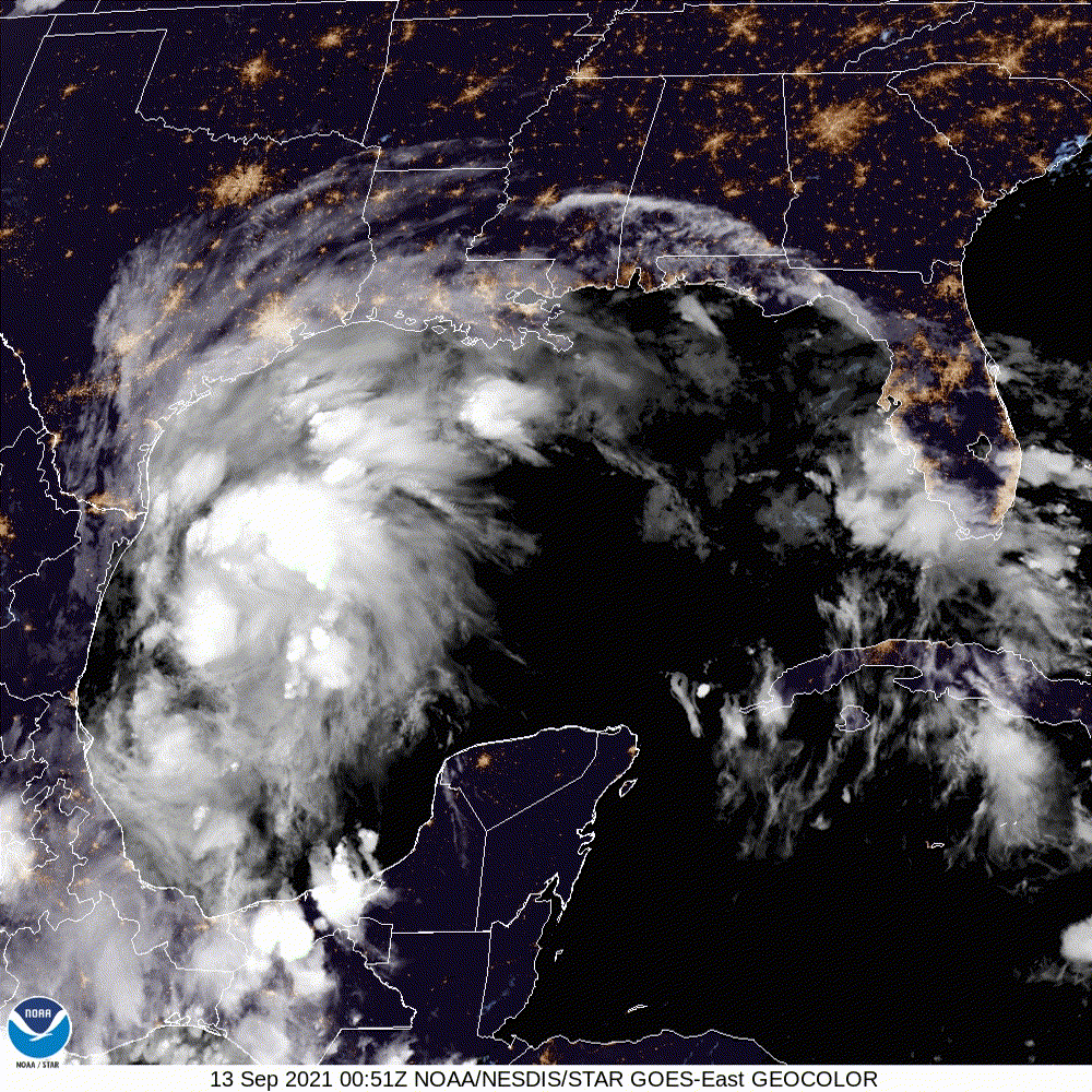

At 60mph already....
Tropical Storm Nicholas Intermediate Advisory Number 4A
NWS National Hurricane Center Miami FL AL142021
100 AM CDT Mon Sep 13 2021
...AIR FORCE RECONNAISSANCE PLANE FINDS THAT NICHOLAS IS CONTINUING
TO STRENGTHEN...
SUMMARY OF 100 AM CDT...0600 UTC...INFORMATION
----------------------------------------------
LOCATION...25.1N 96.5W
ABOUT 70 MI...115 KM SE OF MOUTH OF THE RIO GRANDE
MAXIMUM SUSTAINED WINDS...60 MPH...95 KM/H
PRESENT MOVEMENT...NNW OR 340 DEGREES AT 15 MPH...24 KM/H
MINIMUM CENTRAL PRESSURE...1001 MB...29.56 INCHES

Oh geez. 60 mph already? We may looking at a hurricane come sunrise.
Mike
Beaumont, TX
(IH-10 & College Street)
Beaumont, TX
(IH-10 & College Street)
-
Andrew
- Site Admin

- Posts: 3440
- Joined: Wed Feb 03, 2010 9:46 pm
- Location: North-West Houston
- Contact:
00Z ECMWF has shifted towards the other models with landfall near Matagorda Bay and a track to the northeast. No stall this time. It shows similar rainfall totals like the GFS with most seeing 4-8 inches and pockets of 10-15. Max wind gusts could reach close to 60mph in the city though.
For Your Infinite Source For All Things Weather Visit Our Facebook

From zero to hero on the consolidated center.
- Attachments
-
-
Andrew
- Site Admin
- Posts: 3440
- Joined: Wed Feb 03, 2010 9:46 pm
- Location: North-West Houston
- Contact:
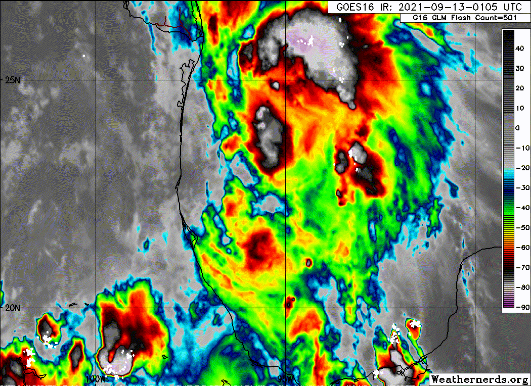
Nicholas still remains sheared to the east and while strengthening has occurred we need to monitor if additional convection can fire to the west.
For Your Infinite Source For All Things Weather Visit Our Facebook
0z Euro in lock step with NHC. Nicholas is cranking, although east sided. Could be a CAT 1 in the morning before shear hampers development .

For a minute I thought my eyes were playing tricks on me and there was another center reformation to the e. Looked that way on satellite but you can still see the current center on BRO radar.
But I go back to yesterday and some of the crazy pinball movements in the GFS and sure enough the 6z GFS has one more center reformation to the e/ene in 3-6 hrs. Don't think it will have a major impact on final landfall just something to look out for.
But I go back to yesterday and some of the crazy pinball movements in the GFS and sure enough the 6z GFS has one more center reformation to the e/ene in 3-6 hrs. Don't think it will have a major impact on final landfall just something to look out for.
-
Andrew
- Site Admin
- Posts: 3440
- Joined: Wed Feb 03, 2010 9:46 pm
- Location: North-West Houston
- Contact:
Southwesterly shear is still impacting the storm a good bit. The center of Nicholas still remains southeast of Brownsville and with not much additional convection firing overhead, it may be difficult to sustain some of the convection further east. Not the healthiest storm, but still a lot more developed compared to yesterday.
For Your Infinite Source For All Things Weather Visit Our Facebook
Storm still seems off to me...
Anyways recon is finally headed towards the storm and will alleviate whatever I think I'm seeing.
Fwiw both hurricane models had a fairly decent shift up the coast being this close to landfall. HWRF shows a reformation like the GFS.
Anyways recon is finally headed towards the storm and will alleviate whatever I think I'm seeing.
Fwiw both hurricane models had a fairly decent shift up the coast being this close to landfall. HWRF shows a reformation like the GFS.
-
Andrew
- Site Admin
- Posts: 3440
- Joined: Wed Feb 03, 2010 9:46 pm
- Location: North-West Houston
- Contact:
KGYF which is approximately 120NM NE of the center is reporting wind speeds of 53kts currently. While the ob is ~200ft above the water it's still impressive the distance that tropical storm-force winds will likely be felt during landfall
For Your Infinite Source For All Things Weather Visit Our Facebook
-
Andrew
- Site Admin
- Posts: 3440
- Joined: Wed Feb 03, 2010 9:46 pm
- Location: North-West Houston
- Contact:
It's possible we see a jump east later today especially if convection fails to fire on the western side of the storm. Some models are picking up on that like you mentioned.Scott747 wrote: ↑Mon Sep 13, 2021 6:26 am Storm still seems off to me...
Anyways recon is finally headed towards the storm and will alleviate whatever I think I'm seeing.
Fwiw both hurricane models had a fairly decent shift up the coast being this close to landfall. HWRF shows a reformation like the GFS.
For Your Infinite Source For All Things Weather Visit Our Facebook
-
Kingwood36
- Posts: 1592
- Joined: Sat Dec 29, 2018 10:29 am
- Location: Freeport
- Contact:
When is he suppose to make landfall? Sometime this evening right?