
Long range model discussion
-
Stratton20
- Posts: 4248
- Joined: Tue Feb 09, 2021 11:35 pm
- Location: College Station, Texas
- Contact:
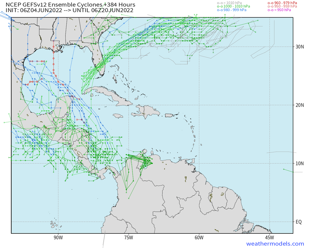
12z GEFS now inside of 10 days, definitely a growing signal, could be another CAG setup
- Attachments
-
Stratton20 wrote: ↑Sat Jun 04, 2022 12:53 pm 12z GEFS now inside of 10 days, definitely a growing signal, could be another CAG setup
-
Stratton20
- Posts: 4248
- Joined: Tue Feb 09, 2021 11:35 pm
- Location: College Station, Texas
- Contact:
Cpv17 even the latest operational GFS is starting to show something
-
Stratton20
- Posts: 4248
- Joined: Tue Feb 09, 2021 11:35 pm
- Location: College Station, Texas
- Contact:
Even the operational 12z CMC is starting to show. hints at development in the gulf on days 8/9
- Attachments
-
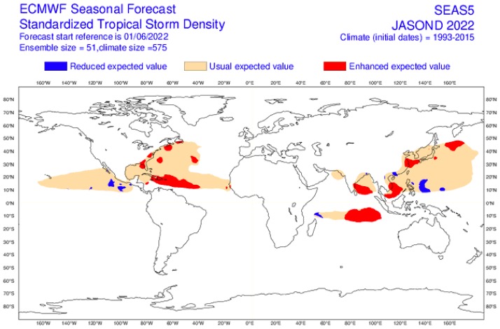
Latest ECMWF seasonal forecast shows an ACE of 225 but it looks much more active for the eastern Gulf than the western Gulf which pretty much agrees with other forecasts I’ve seen as well. I’m not really high on Texas this year having any major tropical impacts if I’m being completely honest but long range seasonal forecasts can often be wrong so we’ll see what happens.

12z CMC actually shows a tropical storm heading towards the middle or upper Texas coast fwiw.GEFS have also been fairly consistent on showing something around that time frame.Middle to late month may be interesting in the gulf, something to watch over the next week will be to see if models start to trend more or not towards TC development.Stratton20 wrote: ↑Sun Jun 05, 2022 1:06 pm Even the operational 12z CMC is starting to show. hints at development in the gulf on days 8/9
- Attachments
-
-
Stratton20
- Posts: 4248
- Joined: Tue Feb 09, 2021 11:35 pm
- Location: College Station, Texas
- Contact:
Don definitely, will say though thats pretty sheared TC on the CMC run, whatever may try to form could be lopsided
That's normal and expected though, most storms developing in June will be weak and sheared lopsided storms.Usually you need to be on the right side of the storm to get decent rain from these kind of systems.The western half of the storm will be completely dry sometimes. (Nicholas last year as an example)Stratton20 wrote: ↑Sun Jun 05, 2022 1:36 pm Don definitely, will say though thats pretty sheared TC on the CMC run, whatever may try to form could be lopsided
-
Stratton20
- Posts: 4248
- Joined: Tue Feb 09, 2021 11:35 pm
- Location: College Station, Texas
- Contact:
Don true I didnt get much from Nicholas , will see if models trend toward this, though will say the operational GFS has been a but wonky to start the hurricane season, with the GEFS being aggressive somewhat, euro should be interesting, talk about a strong signal on the 12 z EPS
- Attachments
-
Usually the Euro/EPS is fairly conservative especially in the long range so if it’s even hinting at anything that should at least raise an eyebrow.
The GFS/GEFS does a better job usually in the longer range of sniffing things out but sometimes it’s too aggressive.
The GFS/GEFS does a better job usually in the longer range of sniffing things out but sometimes it’s too aggressive.
-
Stratton20
- Posts: 4248
- Joined: Tue Feb 09, 2021 11:35 pm
- Location: College Station, Texas
- Contact:
Cpv17 well thats a pretty aggressive signal from the EPS in the western GOM, even the GEPS has a pretty decent signal, interesting days ahead
-
Stratton20
- Posts: 4248
- Joined: Tue Feb 09, 2021 11:35 pm
- Location: College Station, Texas
- Contact:
18z GFS with a 997 mb tropical storm into northern mexico at hour 258( 10 days) we got an interesting week ahead of us for sure
Some pretty heavy hitters that popped up on the 18z GEFS that are aimed at Texas.
-
Stratton20
- Posts: 4248
- Joined: Tue Feb 09, 2021 11:35 pm
- Location: College Station, Texas
- Contact:
Cpv17 yeah I just saw that, interesting but it is june, it would be tough to get a very strong system in the gulf, but definitely raises an eyebrow for sure, overnight models will be interesting
-
TexasBreeze
- Posts: 942
- Joined: Sun Sep 26, 2010 4:46 pm
- Location: NW Houston, TX
- Contact:
Strong west southwest shear has been a constant in the Gulf for awhile now. Still there currently and we will see if it calms down underneath the building upper ridge pattern coming up. Also will see if a weakness happens, but it could be hard for one around here due to drought/ heat.
12Z CMC with a weak tropical storm making landfall around Matagorda similar to yesterdays 12z run FWIW.With decent support from the ensembles of both the CMC and GFS. If something does develop in the gulf, track will depend on the position and strength of ridging.Based on what i see now it looks like the western gulf "could" be a target zone for any tropical moisture or TC development.Could stay to our south and go into Mexico or the Pacific or it could sneak its way further north towards Texas or Louisiana if there's a weakness.Way too early to know of course.We'll know more by this weekend or early next week. And need to see also if the operational EURO starts to pick up on it.
- Attachments
-
-
-
Stratton20
- Posts: 4248
- Joined: Tue Feb 09, 2021 11:35 pm
- Location: College Station, Texas
- Contact:
12z EPS
- Attachments
-
-
Stratton20
- Posts: 4248
- Joined: Tue Feb 09, 2021 11:35 pm
- Location: College Station, Texas
- Contact:
18z GEFS has moved up potential development in the western caribbean, now has a pretty strong signal 7 days out, definitely getting within a range that isnt fantasy, quite a few members on this rub of the GEFS have a pretty strong system getting into the western gulf, kinda raises my eyebrow
- Attachments
-


It would be nice to see rain.
-
Stratton20
- Posts: 4248
- Joined: Tue Feb 09, 2021 11:35 pm
- Location: College Station, Texas
- Contact:
Ptarmigan amen to that!