
From Wxman57 at Storm2k..
Obs indicate SE wind 10-15 kt across the NW Gulf this morning. A very weak surface low may form before it moves into the TX coast tomorrow. No wind threat.
June 2022
That HWRF-P total precipitation is a little too much rain.
I’d post it but I don’t know how. Maybe someone else can.
This is misleading and incorrect.Stratton20 wrote: ↑Tue Jun 28, 2022 3:14 pm djmike they wont put out a cone until a closed low forms, but I see why you would ask that though
-
TexasBreeze
- Posts: 943
- Joined: Sun Sep 26, 2010 4:46 pm
- Location: NW Houston, TX
- Contact:
They have a cone for the ptc out by the Caribbean. It is moving too fast to have a closed circulation and isn't a cyclone yet. The same could be done with our little system at the discretion of nhc.
A few years back they started what's called PTC advisories. Even if a closed circulation hasn't formed yet but there is a likelihood of one forming, or there are depression or tropical storm conditions impacting an area they will begin PTC advisories with a full package that includes watches/warning, discussion and a 'cone.'
This could be a perfect example of such an event even if recon doesn't find a closed circulation later today if the mission isn't cancelled.
Correct. PTC 2 is another perfect example and was initiated because of the potential threat to the southern windwards.TexasBreeze wrote: ↑Wed Jun 29, 2022 8:41 am They have a cone for the ptc out by the Caribbean. It is moving too fast to have a closed circulation and isn't a cyclone yet. The same could be done with our little system at the discretion of nhc.
Here's a little more detailed account on the process for those interested -
https://www.nhc.noaa.gov/outreach/prese ... sories.pdf
-
tireman4

- Global Moderator

- Posts: 4495
- Joined: Wed Feb 03, 2010 9:24 pm
- Location: Humble, Texas
- Contact:
000
FXUS64 KHGX 291145
AFDHGX
Area Forecast Discussion
National Weather Service Houston/Galveston TX
645 AM CDT Wed Jun 29 2022
.AVIATION [12Z TAF Issuance]...
VFR conditions will prevail through the period with easterly winds
this morning turning more southeasterly this afternoon which will
persist through tonight. Scattered coastal storms will impact
HOU, SGR, LBX and GLS through the midmorning before a lull in the
activity. This lull will be short lived as scattered showers and
thunderstorms develop along and south of I-10 this afternoon
impacting potentially IAH southwards. These storms could produce
locally heavy rainfall and gusty winds. The precipitation will
again dissipate after sunset, but expect additional showers and
thunderstorms Thursday morning and through the day as a low
pressure system approaches from the south.
Fowler
&&
.PREV DISCUSSION /Issued 503 AM CDT Wed Jun 29 2022/...
.SHORT TERM [Through Thursday Night]...
Get ready for a wet few days across Southeast Texas. Some nocturnal
thunderstorms developed across the coastal waters early this morning
that may move onshore during the mid morning, but these storms will
dissipated by the late morning. But, additional rain chances are on
the way today. A broad area of low pressure located off the Southern
Texas coastline will be strengthening through the day today. The
northern edge of the rain associated with this developing system
will reach into our region this afternoon, but how far northwards
will heavily depend on the located of the low pressure system. Weak,
unorganized systems like this can be a real forecasting nightmare as
location errors can be very large bringing large differences in the
forecasted rain amounts for a certain location. CAM guidance for
today has been indicating that a band of showers and thunderstorms
will develop across the area along and south of the I-10 corridor in
the mid afternoon and persist through around sunset. PWATs today
will be climbing to around 2 inches along the coast, so the storms
that do develop will be able to produce some locally heavy rainfall.
Generally through the day today rainfall amounts will be between
0.5" to 1.5" with some locally higher totals. However, there will
still be a scattered nature of the developing storms so expect large
variations in the rainfall amounts where one street may get the 1"+
totals while a few streets down may get a trace. Extremely dry
antecedent conditions along the coast will really limit any flooding
potential, but could expect some street ponding in areas of low
lying areas and in areas of poor drainage (construction
areas/underpasses). This is the most likely scenario for today, but
again want to emphasize that the location of the rainfall today will
be highly dependent on the location of the system to our south. If
it develops further south then we could very will get very little
rainfall with the bulk of the storms remaining off the coast, or
could get the storms further inland to the northern part of Harris
County if the system develops further north. The loss of daytime
heating will result in a reduction of the storms later this evening.
This lull in shower activity will not last long as the marine
nocturnal storms develop again after midnight. Then additional
showers and thunderstorms developing across the southern half of
the region. Some isolated storms may extend to Bryan/College
Station area as the low pressure system to the south begins to
move northwards. Additional rainfall of 0.5 to 1" with locally
higher amounts is expected along and south of I-10 on Thursday
with isolated spots of up to 0.5" north of I-10.
Temperatures through the short term will see near seasonal highs
in the low to mid 90s and mild overnight lows in the mid to upper
70s.
Fowler
.LONG TERM [Friday Through Wednesday]...
The beginning of the extended period will continue to be highly
dependent upon the evolution and track of the aforementioned surface
low as it pushes inland along the Middle TX coast on Friday. Global
models are in slightly better agreement on the system`s development
in the most recent runs, with the GFS/EC/NAM showing the low to the
southwest of Matagorda Bay by early Friday. As the system advances
inland throughout the course of the day, the local environment will
be favorable for the development of scattered to numerous showers
and storms which at times could result in periods of locally heavy
rain. Total PW values of 2.0-2.25" continue to indicate abundant
moisture availability, while the continued presence of a stalled
frontal boundary and robust PVA in the midlevels will be conducive
to storm development throughout the day. Locations near the coast
will continue to have the greatest chances for locally heavy rain,
with rainfall amounts steadily decreasing to the north of the I-10
corridor. Widespread additional totals of around 0.5-1" near the
coast are expected while areas north of the I-10 corridor should see
widespread values of around 0.25"-0.5". However, heavy downpours may
produce locally higher amounts at some locations and as such the WPC
has placed our southern zones within a Marginal Risk area for
excessive rainfall (i.e., a 5% chance that flash flood guidance will
be exceeded within 25 miles of a given point within the area).
Widespread cloud cover and precipitation will give us our coolest
day in quite some time, with daytime highs maxing out in the upper
80s.
A gradual return to a more typical summertime pattern will begin on
Saturday as the system pushes out of the area, though associated
lingering showers/storms will continue throughout the day. Aloft,
strong midlevel ridging will build back into the South Central CONUS
with 500mb heights reaching around 594-596 dam by early Sunday while
at the surface a steady onshore flow will redevelop. As this pattern
takes hold through the weekend and into next week, a gradual
increase in temperatures will drive highs into the mid/upper 90s by
Monday and the mid/upper 90s by mid-week. Typical sea/bay breeze
thunderstorm activity will keep PoP values around 15-20% across the
southern zones through mid-week, although these chances will begin
to diminish thereafter as mid/upper ridging builds in directly
overhead. Overnight lows remain relatively steady in the upper 70s
inland and low 80s along the coast.
Cady
.MARINE...
A weak area of low pressure continues to produce disorganized shower
and thunderstorm activity over the northwestern Gulf of Mexico. The
low will move slowly west to west-southwest towards the middle Texas
Coast over the next day or two. As a result, winds of 15 to 20 kts
with gusts to 25 kt and seas up to 4 to 6 feet will persist
through Friday. There will also be continued chances of scattered
showers and thunderstorms through Friday over the Gulf waters.
The low has a medium chance of developing into a short-lived
tropical depression on Thursday before moving into the middle
Texas Coast. Small crafts should exercise caution. There will also
be an increasing risk of rip currents tomorrow through the end of
the week. Rain and thunderstorm chances along with winds and seas
will decrease by the weekend.
Self
.TROPICAL...
The National Hurricane Center continues to monitor the potential
for tropical develop of the low pressure system located off of
South Texas (95L) before moving into Southeast Texas. The NHC
gives it a Medium Chance (40%) chance of development into a short
lived Tropical Depression within the next 2 days. Whether or not
this system develops tropical features will not really change the
main impacts to our region which is locally heavy rainfall each
day through Friday along with increased threat of strong rip
currents.
Fowler
&&
.PRELIMINARY POINT TEMPS/POPS...
College Station (CLL) 97 74 94 74 89 / 20 10 30 20 40
Houston (IAH) 95 76 90 77 87 / 40 20 60 40 60
Galveston (GLS) 91 80 89 81 86 / 50 40 70 50 70
&&
.HGX WATCHES/WARNINGS/ADVISORIES...
TX...SMALL CRAFT SHOULD EXERCISE CAUTION through this evening for the
following zones: Brazoria Islands...Galveston
Island...Matagorda Islands.
GM...SMALL CRAFT SHOULD EXERCISE CAUTION through this evening for the
following zones: Coastal waters from Freeport to Matagorda
Ship Channel TX out 20 NM...Coastal waters from High Island
to Freeport TX out 20 NM...Waters from Freeport to
Matagorda Ship Channel TX from 20 to 60 NM...Waters from
High Island to Freeport TX from 20 to 60 NM.
&&
$$

12Z Models
- Attachments
-
I like that track, but wish some of this offshore goodness would come inland already. I stopped watering on Saturday because we were suppose to get rain starting Sunday night, but so far have seen absolutely nothing.
Definitely looks like Houston and points east of there are gonna get some pretty good rain.
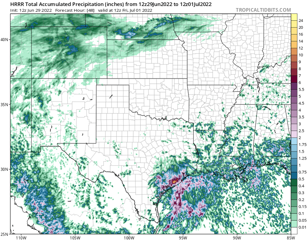
12z HRRR doesn’t look too bad. It only goes out to 48 hours so that’s why it doesn’t show anything further north yet.
If it continues to dip to the SW and the energy doesn't fully transfer to the convention to the n before it begins to lift then I think down your way and towards Matagorda could see some decent rain.
If it tightens up a little quicker it sure would help you out...
-
Stratton20
- Posts: 4250
- Joined: Tue Feb 09, 2021 11:35 pm
- Location: College Station, Texas
- Contact:
good blow up of convection near 95L, we will see if it tries to tighten up today
The NAM and its suite of models are now all onboard with TC development.After dropping development yesterday.All of them show a Depression or weak storm now.Rainfall amounts have gone WAY UP on the 3k NAM also...
- Attachments
-
-
How reliable is the NAM at modeling rainfall?
-
Stormlover2020
- Posts: 457
- Joined: Mon Jun 01, 2020 6:04 pm
- Contact:
We will see another shift east, somebody going to get 15-20 inches mark it down
-
Stratton20
- Posts: 4250
- Joined: Tue Feb 09, 2021 11:35 pm
- Location: College Station, Texas
- Contact:
I dont think so and I hope not, models are pretty locked in around a landfall or just west of matagorda bay