
July 2022
-
Stratton20
- Posts: 4281
- Joined: Tue Feb 09, 2021 11:35 pm
- Location: College Station, Texas
- Contact:
Noaa 6-10 and 8-14 day outlooks for precipitation are trending in a positive direction for SE Texas!

I need this cell approaching IAH to hold together!
Come on!! Come to papa!!
Come on!! Come to papa!!
-
tireman4

- Global Moderator

- Posts: 4516
- Joined: Wed Feb 03, 2010 9:24 pm
- Location: Humble, Texas
- Contact:
00
FXUS64 KHGX 061737
AFDHGX
Area Forecast Discussion
National Weather Service Houston/Galveston TX
1237 PM CDT Wed Jul 6 2022
.AVIATION [18Z TAF Issuance]...
Even with activity trying to move in from the east, will keep the
mention of precipitation out of the TAFs (for now). While most of
the more organized activity is expected to remain east of the IAH
/HOU/GLS terminals...cannot really discount the possibility of an
isolated storm (or two) making it into these sites (from outflows
et al). Otherwise, will keep with VFR conditions through a major-
ity of the afternoon/overnight hours. Light south winds toady and
tonight should give way to a light more SW flow tomorrow. 41
&&
That cell is going poof!
TWC rain chances down to 40% now.
TWC rain chances down to 40% now.

lol. Same for me.cperk wrote: ↑Wed Jul 06, 2022 11:58 amI'm not falling for it,i'll believe it when i see it falling from the sky.Stratton20 wrote: ↑Wed Jul 06, 2022 11:54 am All models are now on board that the ridge will back off to the west and allow a back door front to move in next week and stall out, leading to daily appreciable rain chances! Looks like a pattern change is coming!
Everything went poof. TWC app now shows no rain. What a joke that app is. NWS was right with about 20%
-
captainbarbossa19

- Posts: 405
- Joined: Mon Jun 28, 2021 2:50 pm
- Location: Starkville, MS
- Contact:
I like the 12z Euro a lot more than the last few runs. E and NE flow at 700mb is almost always good in the summer.
Yep, that was a bad fire ... sparked by months of antecedent heat and dry prior. I don't want to imagine how much more devastation the same amount of prolonged freezing weather would do

True.captainbarbossa19 wrote: ↑Wed Jul 06, 2022 6:37 pm I like the 12z Euro a lot more than the last few runs. E and NE flow at 700mb is almost always good in the summer.


If there is a consensus among forecast models, I consider it high confidence.Stratton20 wrote: ↑Wed Jul 06, 2022 12:04 pm cperk all 3 major models are on board lol, no guarantee you will get anything, but at least it looks like you might have a better chance of getting some needed rain next week, but I feel ya, their seems to be a shield across CS keeping all the rain away from us, it sucks lol
-
Stratton20
- Posts: 4281
- Joined: Tue Feb 09, 2021 11:35 pm
- Location: College Station, Texas
- Contact:
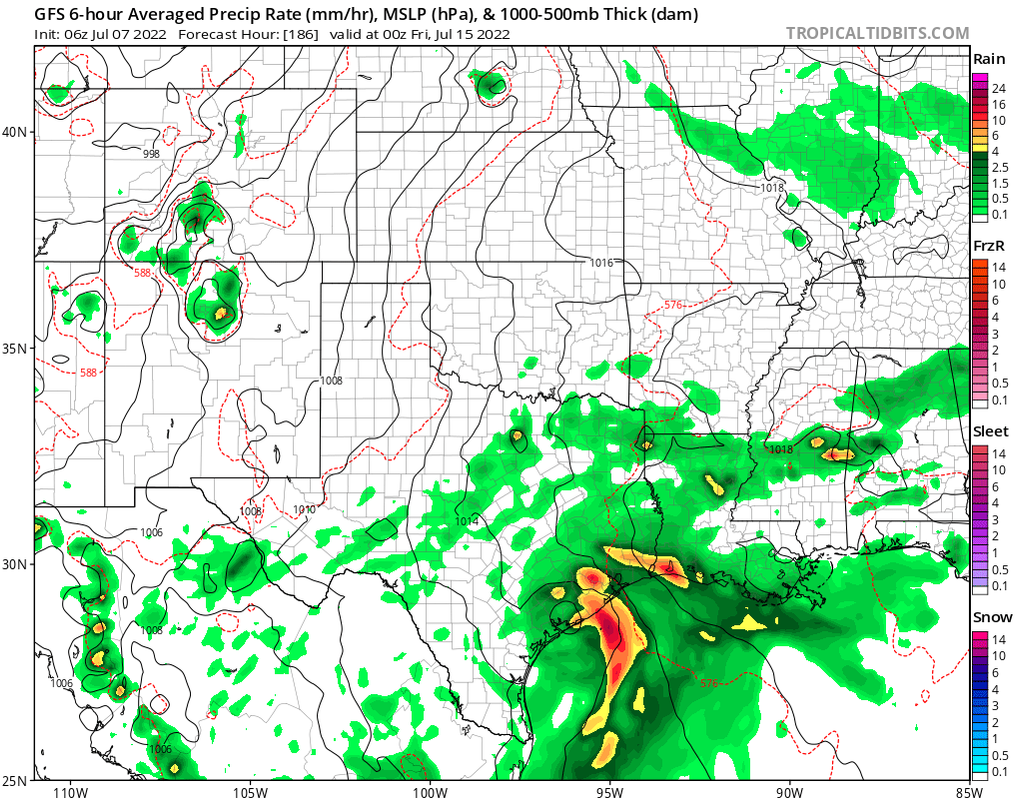
Its far out, but next week the GFS is showing some big rain fall totals albeit over the gulf and into Lousiana with a hint of TC genesis in the NW Gulf, 9 days out but just something id thought id mention fwiw, has a swath of 15-20 inches across SW Lousiana lol, GFS gonna GFS

Must it ALWAYS be Louisiana? Really sickening ...
Still overall better trends, nonetheless.
Still overall better trends, nonetheless.
6z GFS shifted it 100 miles further west.Stratton20 wrote: ↑Thu Jul 07, 2022 12:02 am Its far out, but next week the GFS is showing some big rain fall totals albeit over the gulf and into Lousiana with a hint of TC genesis in the NW Gulf, 9 days out but just something id thought id mention fwiw, has a swath of 15-20 inches across SW Lousiana lol, GFS gonna GFS
-
TexasBreeze
- Posts: 944
- Joined: Sun Sep 26, 2010 4:46 pm
- Location: NW Houston, TX
- Contact:
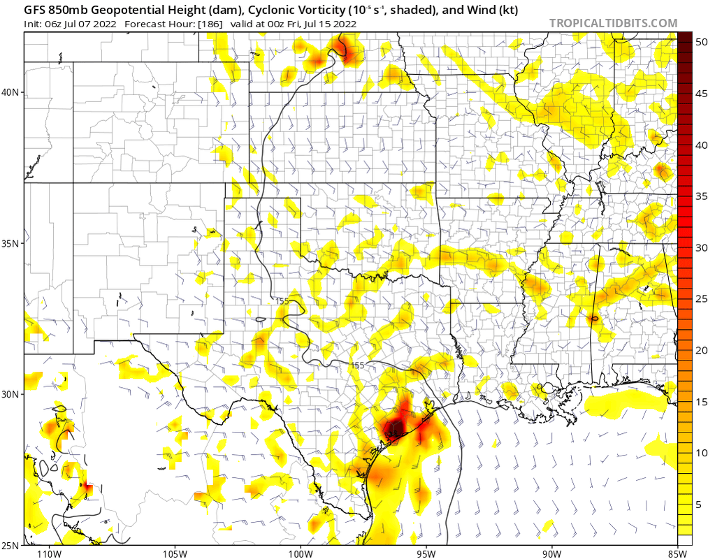
Yes another future invest threat to keep an eye out. Sounds familiar!
6z GFS with a depression or weak tropical storm into Matagorda next Thursday:
-
tireman4
- Global Moderator
- Posts: 4516
- Joined: Wed Feb 03, 2010 9:24 pm
- Location: Humble, Texas
- Contact:
00
FXUS64 KHGX 071129
AFDHGX
Area Forecast Discussion
National Weather Service Houston/Galveston TX
629 AM CDT Thu Jul 7 2022
.AVIATION [12Z TAF Issuance]...
VFR conditions will prevail throughout the TAF period. SW winds
this morning will veer to the SE in the afternoon. A few showers
and thunderstorms may develop this afternoon near the metro
terminals (KIAH, KHOU, KSGR). These showers and thunderstorms
should taper off this evening with light SW winds developing
overnight and continuing into Friday morning. 03
&&
.PREV DISCUSSION /Issued 339 AM CDT Thu Jul 7 2022/...
.DISCUSSION...
Hot temperatures - even by the usual "Southeast Texas in summer"
standards - will be the main weather story going into the weekend
and early next week. Most inland places should expect highs around
100, give or take a couple, with heat index values also right up
around the heat advisory threshold. Even the coast, though
slightly cooler, should see highs in the 90s and peak heat index
values easily into the triple digits. Things won`t get
meaningfully cooler overnight, as high dewpoints will keep
overnight lows in the upper 70s and low 80s
At the risk of sounding a bit like a broken record, even though
this stretch looks like it will fall into the rough range of high
end, but not unheard of heat, even typical dog days of summer
conditions in Southeast Texas can be dangerous for those who do
not plan to take precautions, and even more dangerous for those
who are unable to take precautions. If your plans take you
outdoors this weekend (And they should! The weather`s great!),
please also take some time to preempt any potential threat from
the heat and ensure all stay free of heat illness.
.SHORT TERM [Through Friday Night]...
A few afternoon showers and isolated thunderstorms could develop
along the coast today as the remnants of yesterday`s shortwave
pass overhead. Rain chances still look best during the afternoon
hours, with sea breeze interactions aiding the development of
these showers. However, coverage of these showers will still be
limited as mid to upper level ridging strengthens overhead. The
additional subsidence from this ridge will work to decrease cloud
cover and increase temperatures by a degree or so compared to
yesterday. This will bring highs in the mid to upper 90s with some
areas north of I- 10 looking to break triple digits. Even with
dewpoints mixing out, heat indicies will still exceed 105 in the
afternoon. Conditions will still be warm even after the sun sets,
with lows bottoming out in the upper 70s to lower 80s overnight.
By Friday, a mid level high over the four corners region will
strengthen with its associated ridge, allowing for 500mb heights
over SE Texas to increase to around 595-596 dam. With 850mb
temperatures rising to around 21-23C, temperatures at the surface
will follow suit. Areas north of I-10 could see highs in the upper
90s to lower 100s with areas to the south seeing highs in the mid to
upper 90s. Heat indicies across the region will peak around 106-107,
putting us close to heat advisory criteria, especially in portions
of the Brazos Valley where the air temperatures may exceed 103F.
Needless to say, it will be hot and unpleasant, so make sure to
practice heat safety wherever you are.
.LONG TERM [Saturday Through Thursday]...
600 dam High at 500 mb? Who ordered the 600 dam High at 500 mb?!
Guidance continues to advertise 500 mb heights over the Four
Corners in the 597-600 dam range, and though the deterministic
Euro has backed off ever so slightly and no longer explicitly
advertises the 600 mark, we`re functionally there. Both the NAEFS
and EPS ensemble means are maxing out their climatological
percentiles for 500 mb heights this weekend in a strong display of
Big Ridge Energy, or BRE, as The Kids would say (The Kids do not
say this). Perhaps unsurprisingly, this coincides with EFI values
for high temps in the 0.7-0.9 range, indicating a strong heat
signal for the weekend and even very early next week. Overnight,
it may even be slightly worse (relatively speaking). We can
probably expect more daily records to fall for high minimum
temperature.
As we head into next week, the midlevel ridge does look to weaken
somewhat, though as the NAEFS and EPS percentiles only seem to
fall back towards the 90th percentile, any "cooling" will be slow
and modest. Though we may eventually see less potential for heat
advisories, unseasonably hot conditions should persist for the
first half of the week, and perhaps even longer. There is a bit of
a hint in deterministic guidance that we could see a weak front
drift in from the north later next week, but the ensemble trends
in 500 heights are heading back up, so...I`m not gonna hold my
breath for serious relief just yet.
Beyond temps, is there anything else to look forward to? Yes,
actually! We should see a shot for at least an isolated shower or
storm (like we saw around the loop east of I-45 yesterday!) each
day. And, towards the middle of next week, the midlevel ridge
looks to weaken just enough that a more potent vort max looks to
ride along the southern side of the ridge across the Gulf Coast,
and be able to tap into ample moisture and seabreeze convergence
to give us better convective coverage towards the middle week.
Just, uh...don`t look at what the 00Z Euro thinks of this idea.
There`s a reason I`m only just barely pushing my PoPs up into the
"chance" range at this point. But, it`s probably the best look
we`ve got in the week to come.
.MARINE...
High pressure continues its reign over the region. This general
scenario is pretty seasonable, so wind patterns will likely be
fairly familiar - generally onshore, but near the shore more of a
landbreeze late at night, more of a seabreeze in the afternoon.
Winds will be a bit SCECy in the late evening and overnight hours
as they drift up closer to 15 knots, then back down closer to 10
knots during the day.
Rain chances will be pretty minimal, especially through the
weekend when the ridge is at its strongest. Even then, there is at
least a little chance for a shower or two, mainly over the Gulf
early in the morning. We should expect to see modestly greater
coverage as we head deeper into next week and the ridging weakens
a little bit.
.CLIMATE...
Another day, another record high minimum temperature at Galveston.
For the third straight day, Scholes Field saw an overnight low of
only 85 degrees. This record eclipses the old record of 84, last
seen in 1994 - one of the increasingly uncommon 20th Century
records in this category on the Island. It is also the fourth
consecutive record high minimum temperature.
&&
.PRELIMINARY POINT TEMPS/POPS...
College Station (CLL) 102 77 103 78 104 / 0 0 0 0 0
Houston (IAH) 97 78 98 79 101 / 20 0 0 0 10
Galveston (GLS) 93 85 94 85 92 / 20 0 0 0 10
&&
.HGX WATCHES/WARNINGS/ADVISORIES...
TX...None.
GM...None.
&&
$$
DISCUSSION...Luchs
SHORT TERM...03
LONG TERM...Luchs
AVIATION...Brokamp
MARINE...Luchs
CLIMATE...Luchs
^ yeah the Euro isn’t showing anything. We should definitely be rooting for the GFS and hope the Euro starts to change towards it.
-
Stratton20
- Posts: 4281
- Joined: Tue Feb 09, 2021 11:35 pm
- Location: College Station, Texas
- Contact:
Cpv17 alot of rain fall on that run as well, still far out but worth monitoring, we always seem to get these big rain events after a long stretch of mostly dry weather
-
Stormlover2020
- Posts: 457
- Joined: Mon Jun 01, 2020 6:04 pm
- Contact:
Don’t buy it gfs been horrible