
I’m hearing the MJO is going to play a huge factor in this potential cold because they aren’t sure which phase it’s gonna be in yet.Stratton20 wrote: ↑Sun Jan 22, 2023 1:22 pm Very impressive build up of cold air on the euro (12z) bring that stuff south baby!🥶🥶
January 2023


Can that SW ridge and Arctic air create an over running setup?
And what is the high pressure associated with the arctic air mass?
-
Stratton20
- Posts: 4269
- Joined: Tue Feb 09, 2021 11:35 pm
- Location: College Station, Texas
- Contact:
sambucol yes the SE ridge can help to create an overrunning or winter storm setup, especially ice storm setups as the warm se flow can overrun cold arctic air, as long as the ridge doesnt get too close though, the euro has a 1050 mb high in NW canada

Yep the 12Z Euro has the SE ridge displaced much further east.And also shows the arctic air being dense and shallow enough to undercut the ridge at the end of its run FWIW.Looking more and more likely now that our source region will finally be getting filled with arctic air again.Just a question if we can get a setup to dislodge the arctic air down south.
Hopefully, that air mass plunges this way all the way through the Texas coast.
-
Stratton20
- Posts: 4269
- Joined: Tue Feb 09, 2021 11:35 pm
- Location: College Station, Texas
- Contact:
The 12z CMC has the arctic air penetrating all the way down to the coast
As do the ensembles as well. Confidence is growing.Stratton20 wrote: ↑Sun Jan 22, 2023 1:54 pm The 12z CMC has the arctic air penetrating all the way down to the coast
This was posted over on S2K by “orangeblood”.
Just thought I’d share it here as well:
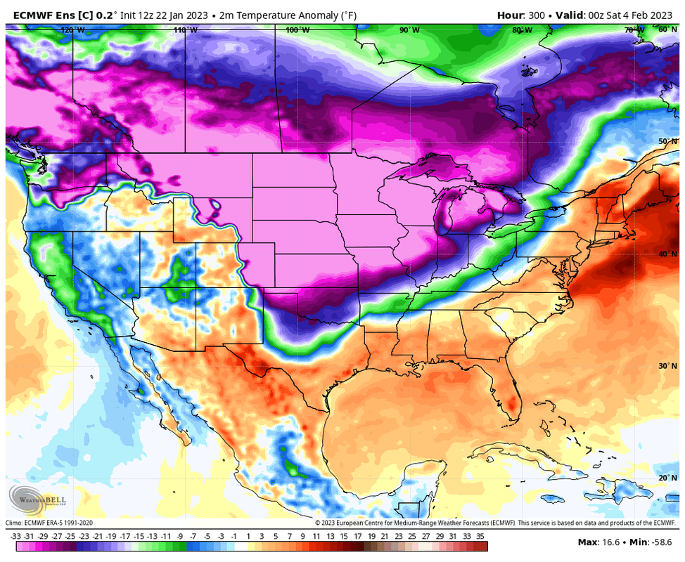
Has temp anomalies of almost 60°F below normal coming down.
This is the 12z Euro control run, btw.
Just thought I’d share it here as well:
Has temp anomalies of almost 60°F below normal coming down.
This is the 12z Euro control run, btw.
If that Arctic cold with an over running setup happens, that would produce a winter precip event more than likely. Bad thing would be an ice event.
It depends on the strength/proximity of the SE or E coast ridge to see how much it would impact or sensible weather. And also would depend upon the depth of the potential cold air headed this way. And of course the biggest factor would be if there’s even any system/energy around to produce precipitation.
-
MontgomeryCoWx

- Posts: 2356
- Joined: Wed Dec 14, 2011 4:31 pm
- Location: Weimar, TX
- Contact:
I haven’t wavered on February being well below. Glad to see it coming around to my thinking.
I’ve seen others yell warm February and then lazy analysis as to why. I use old school tools from my Grandfather and use models as a tool, not an end all be all.
I’ve seen others yell warm February and then lazy analysis as to why. I use old school tools from my Grandfather and use models as a tool, not an end all be all.
Team #NeverSummer
-
MontgomeryCoWx
- Posts: 2356
- Joined: Wed Dec 14, 2011 4:31 pm
- Location: Weimar, TX
- Contact:
We have drought insurance! Just got a check for 5 grand last week for last year. That was my net on the premium.Cpv17 wrote: ↑Sun Jan 22, 2023 12:21 pmIt doesn’t rain as much in Weimar as it does in Montgomery County. You won’t be too far from me. I’m pretty much exactly one hour SE of Weimar. And when you live on a farm, rain is almost always welcomed. Gladly take it.MontgomeryCoWx wrote: ↑Sun Jan 22, 2023 12:12 pm If SETX can't get ice/snow, I'll take 3 plus inches of rain to fill up my tanks at the farm. All day every day after the last year.
Team #NeverSummer
Updated qpf amounts from the WPC.
- Attachments
-
-
Stratton20
- Posts: 4269
- Joined: Tue Feb 09, 2021 11:35 pm
- Location: College Station, Texas
- Contact:
18z GFS breaks down the south east ridge, arctic air on our doorstep on the 30th
just a quick shot of arctic air though
just a quick shot of arctic air though
- Attachments
-
-
brazoriatx
- Posts: 329
- Joined: Tue Nov 08, 2011 12:09 pm
- Contact:
Quick shot ain't even worth it ya know lol give us atleast 3 or 4 days of cold temps
-
Stratton20
- Posts: 4269
- Joined: Tue Feb 09, 2021 11:35 pm
- Location: College Station, Texas
- Contact:
brazoriatx the GFS has a known progressive biacy with arctic airmasses,
Let’s wait for the 18z GEFS to finish running to get a better handle on the length of the cold.

Things are looking interesting on the Canadian about Feb 1, Groundhog Day, etc. Deep cold from the Rockies and some precip behind the front. The 0Z run could be interesting.
Just to reiterate: CMC nailed the Feb 2021 storm. GFS lol
Just to reiterate: CMC nailed the Feb 2021 storm. GFS lol