
April 2023
Rough afternoon on Lake Limestone.. sheesh

-
Stratton20
- Posts: 4248
- Joined: Tue Feb 09, 2021 11:35 pm
- Location: College Station, Texas
- Contact:
CS is now included in the severe thunderstorm watch, maybe a line over night? Most of the activity is to the NW
^Probably an outflow about midnight.
-
Stratton20
- Posts: 4248
- Joined: Tue Feb 09, 2021 11:35 pm
- Location: College Station, Texas
- Contact:
Tornado warned Cell near Milano moving SE at 30 mph in the general direction of CS, hope it fizzles out
I see the hook echo. It's going to be close...the cell took a right turn around Temple.Stratton20 wrote: ↑Sun Apr 02, 2023 9:39 pm Tornado warned Cell near Milano moving SE at 30 mph in the general direction of CS, hope it fizzles out
I'm still going with an outflow and maybe 7-8 big drops of rain.
The cell could turn into a pumpkin at 10 pm.
The National Weather Service in League City has issued a
* Severe Thunderstorm Warning for...
Central Burleson County in southeastern Texas...
West central Brazos County in southeastern Texas...
* Until 1000 PM CDT.
* At 912 PM CDT, a severe thunderstorm with a history of producing
large hail was located 8 miles northeast of Rockdale, moving
southeast at 30 mph.
HAZARD...60 mph wind gusts and half dollar size hail.
SOURCE...Radar indicated.
IMPACT...Hail damage to vehicles is expected. Expect wind damage
to roofs, siding, and trees.
* Locations impacted include...
Caldwell, Deanville and Chriesman.
TORNADO...POSSIBLE
HAIL THREAT...RADAR INDICATED
MAX HAIL SIZE...1.25 IN
WIND THREAT...RADAR INDICATED
MAX WIND GUST...60 MPH
Instructions: A Tornado Watch remains in effect until 100 AM CDT for southeastern Texas. For your protection move to an interior room on the lowest floor of a building. A Tornado Watch remains in effect until 100 AM CDT for southeastern Texas.
Target Area:
Brazos
Burleson
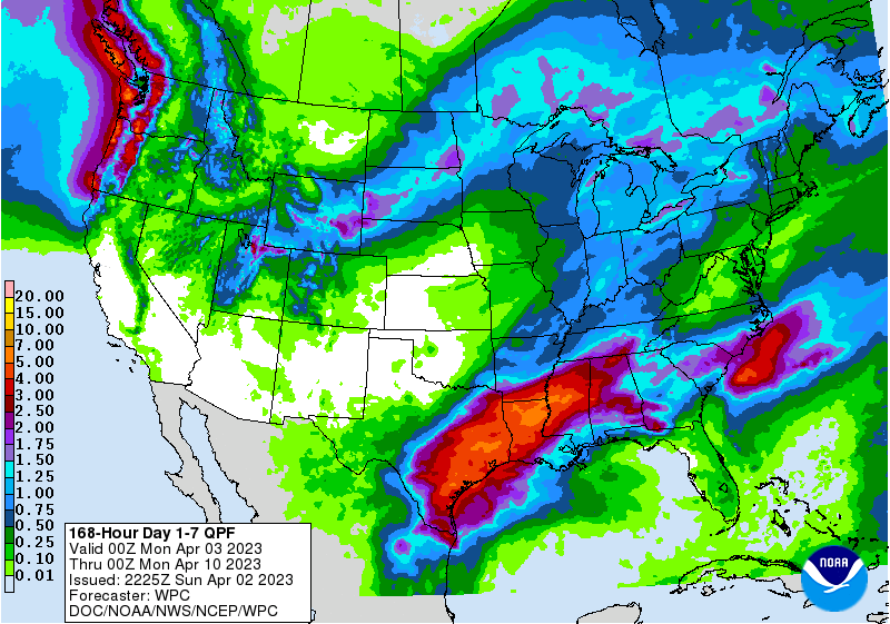
Updated QPF totals from the WPC:

-
Stratton20
- Posts: 4248
- Joined: Tue Feb 09, 2021 11:35 pm
- Location: College Station, Texas
- Contact:
00z Euro is an absolute gully washer for the houston metro, 6-8 inches with an isolated pocket of around 12 inches
GEPS, CMC, GFS average out to the heavy action SE of Hwy 1*5. We'll see some rain in CLL, but not flooding type. We're still days out.
Another severe, tornado threat continuing to our east and north Tuesday, even into Wed. Here we go again.
Oh, 0.04 inches this evening, on cue.
Another severe, tornado threat continuing to our east and north Tuesday, even into Wed. Here we go again.
Oh, 0.04 inches this evening, on cue.
-
Stratton20
- Posts: 4248
- Joined: Tue Feb 09, 2021 11:35 pm
- Location: College Station, Texas
- Contact:
Doctormu guess we will just have to see where the front stalls and if it wobbles north or south any, that can greatly change where the heaviest rainfall may be focused, not something the global models can depict well, guess will see what the short range models show in a few days
-
Iceresistance
- Posts: 577
- Joined: Fri Apr 30, 2021 11:48 pm
- Location: Tecumseh, OK
- Contact:
Daily -SOI streak now at 7 days!
Love that! Where’s the heart eyes emoji at?
I hope Lucy isn't placing a giant football again. Everytime we've been progged for rain lately we haven't gotten jack.
-
tireman4

- Global Moderator

- Posts: 4488
- Joined: Wed Feb 03, 2010 9:24 pm
- Location: Humble, Texas
- Contact:
00
FXUS64 KHGX 031059
AFDHGX
Area Forecast Discussion
National Weather Service Houston/Galveston TX
559 AM CDT Mon Apr 3 2023
...New AVIATION...
.SHORT TERM...
(Today through Tuesday Night)
Issued at 237 AM CDT Mon Apr 3 2023
An 589 dam mid level ridge will be loom over Gulf of Mexico today,
though the upper level flow pattern should remain relatively zonal.
Breezy southerly winds can be expected during the day as a surface
low spins up over the Rockies/Central Plains. PWs will trickle up
towards 0.8-1.1" during the afternoon, though a strong subsidence
inversion near 900mb should suppress convective activity and keep
PoPs near zero. 850mb temperatures are progged to peak near 18-21
during this time frame with 850mb winds out of the southwest.
Combined with reduced cloud cover, these factors should strengthen
heating throughout the afternoon. The current deterministic NBM puts
highs near the 25th percentile for today, which seems a tad cool
given this kind of pattern. I`ve decided to lean towards the NBM
50th for today, putting highs in the lower 90s inland and 80s near
the coastline. Cloudy skies should fill back in tonight with lows
progged to be in the upper 60s/lower 70s.
A mid to upper level trough over the Four Counters/Rockies is
expected to fill NE on Tuesday. As it does, the trough will take on
a negative tilt with a warm front-dryline-cold front developing
about its surface low over the Central Plains/Middle Mississippi
River Valley. The southernmost portion of the dryline seems to
slow/stall over Central TX/Red River Valley during the day. SE Texas
looks to be capped by a strong subsidence inversion with (-50) to (-
100) J/KG of sfc CIN area-wide during the afternoon. PWs do rise to
1.5-1.6" during this time frame with MLCAPE progged to be near 1500-
2000 J/kG and SRH at 100-200 m2s2. Despite these conducive
ingredients, the lack of upper level support or any strong lifting
mechanism will make it difficult for any storms to develop. Rising
moisture and shortwave energy passing overhead should also bring
cloudy skies during the day as well, limiting heating and keeping
highs in the 80s across the region.
A cold front associated with the aforementioned surface low/upper
trough should approach the Brazos Valley early Wednesday morning,
bringing showers and storms into the next day.
03
&&
.LONG TERM...
(Wednesday through Sunday)
Issued at 237 AM CDT Mon Apr 3 2023
Say goodbye to the heat and humidity, and hello to cool and wet
weather for the majority of the long term period. A cold front
will be moving into the region Wednesday morning bringing showers
and thunderstorms along and ahead of the front. This front will
stall near the coast Wednesday afternoon and remain there through
potentially as long as Saturday. A train of shortwaves will be
moving overhead as this stalled boundary remains over us producing
scattered showers and isolated thunderstorms each day. PWATs
remain near 1.6 to 1.9" for most of the long term, so each day
will have a chance of producing up to 1 to 2" of rain, or more if
training sets up. We have been fairly dry each recently, so
grounds will be able to hold a fair amount of precipitation, but
we will be monitoring for any flooding potential as the week
progresses. The front finally moves to the east Saturday night
into Sunday with high pressure building in behind it, so the
precipitation chances look to lower significantly by the end of
the long term.
With overcast skies and daily precipitation, temperatures through
the long term will see below normal high temperatures, but near
normal low temperatures. The cloud cover will prevent much daytime
heating, but then insulate us during the overnight periods. High
temperatures on Wednesday will still manage to climb into the mid
to upper 70s for most of the area and low 80s along the coast
thanks to the WAA out ahead of the approaching cold front. Then
highs Thursday and Friday will be in the low to mid 60s, then
into the 70s on Saturday and near 80 on Sunday as we begin to dry
out. Low temperatures will be in the 50s through Friday, then up
into the low to mid 60s by the weekend.
Fowler
&&
.AVIATION...
(12Z TAF Issuance)
Issued at 543 AM CDT Mon Apr 3 2023
MVFR/IFR CIGS should begin to lift/scatter this morning while
breezy southerly winds develop across the region. VFR conditions
return for most of SE Texas this afternoon with gusts approaching
20 to 25 knots. MVFR CIGS should fill back in later this evening,
then subsequently lift/scatter out Tuesday morning.
03
&&
.MARINE...
Issued at 237 AM CDT Mon Apr 3 2023
Onshore flow of 15 to 20kts will develops today and continue
through at least midweek with seas four and six feet. Patchy fog
will remain a possibility into Tuesday morning. Small craft will
likely have to exercise caution tonight with the potential need of
a Small Craft Advisory in the offshore waters as the wind gusts
up to 25kts. These borderline SCA conditions will continue
through late Tuesday night, but an approaching front will lead
winds to become light and variable Wednesday. The continued
onshore flow will likely lead to a high risk of strong rip
currents through Wednesday. Northeasterly flow of 15 to 20kts will
develop Wednesday night strengthening to 20 to 30kts on Thursday
and then 15 to 20kts on Friday into next weekend. Expect periods
of showers and thunderstorms Wednesday into Saturday as a train of
disturbances move through the area.
Fowler
&&
.PRELIMINARY POINT TEMPS/POPS...
College Station (CLL) 92 71 88 63 / 0 0 0 50
Houston (IAH) 92 74 88 69 / 0 0 0 20
Galveston (GLS) 81 74 81 71 / 0 0 0 10
&&
.PRELIMINARY POINT TEMPS/POPS...
College Station (CLL) 92 71 88 63 / 0 0 0 50
Houston (IAH) 92 74 88 69 / 0 0 0 20
Galveston (GLS) 81 74 81 71 / 0 0 0 10
&&
.HGX WATCHES/WARNINGS/ADVISORIES...
TX...None.
GM...None.
&&
$$
SHORT TERM...03
LONG TERM....Fowler
AVIATION...03
MARINE...Fowler
NAM this morning has the front making it to the coast, then backing up just S of Hwy 1*5 on Friday. We'll see how the impulses ride over the front.Stratton20 wrote: ↑Mon Apr 03, 2023 3:06 am Doctormu guess we will just have to see where the front stalls and if it wobbles north or south any, that can greatly change where the heaviest rainfall may be focused, not something the global models can depict well, guess will see what the short range models show in a few days
CMC sees it the way I do. We'll see.

-
Stratton20
- Posts: 4248
- Joined: Tue Feb 09, 2021 11:35 pm
- Location: College Station, Texas
- Contact:
I think we will see some good rains out of this, im taking the average totals between the GFS, euro and Cmc, something to note is the CMC has been the outlier or driest solution across our region, I think 1-3 inches for most folks is a good bet, but this is the type of setup where a few miles can mean the difference between someone getting 1-2 inches and someone getting 6-8+ inches