

Yep models are developing a surface low that moves slowly north through the area with some very heavy rain associated with it.Some models even show a feeder band like setup once the surface low is north of us mid week.
May 2023
-
Stratton20
- Posts: 4281
- Joined: Tue Feb 09, 2021 11:35 pm
- Location: College Station, Texas
- Contact:
Yeah that will be intriguing to watch, the CMC even has a secondary surface low forming which explains its really high rain fall totals, lots to watch
12Z EURO showing the surface low taking shape on Tuesday.Then moving into north Texas and becoming a tropical like low with a feeder band draped over the area.
.
The RGEM shows this too.don wrote: ↑Sun May 07, 2023 1:44 pm 12Z EURO showing the surface low taking shape on Tuesday.Then moving into north Texas and becoming a tropical like low with a feeder band draped over the area.Screenshot 2023-05-07 at 13-17-19 Models ECMWF Hi-Res — Pivotal Weather.png.Screenshot 2023-05-07 at 13-16-55 Models ECMWF Hi-Res — Pivotal Weather.pngScreenshot 2023-05-07 at 13-17-42 Models ECMWF Hi-Res — Pivotal Weather.png
-
Stratton20
- Posts: 4281
- Joined: Tue Feb 09, 2021 11:35 pm
- Location: College Station, Texas
- Contact:
12z Euro coming in much more aggressive now, 6-8 inches widespread with multiple 10+ inch bullseyes
- Attachments
-
YepCpv17 wrote: ↑Sun May 07, 2023 2:01 pmThe RGEM shows this too.don wrote: ↑Sun May 07, 2023 1:44 pm 12Z EURO showing the surface low taking shape on Tuesday.Then moving into north Texas and becoming a tropical like low with a feeder band draped over the area.Screenshot 2023-05-07 at 13-17-19 Models ECMWF Hi-Res — Pivotal Weather.png.Screenshot 2023-05-07 at 13-16-55 Models ECMWF Hi-Res — Pivotal Weather.pngScreenshot 2023-05-07 at 13-17-42 Models ECMWF Hi-Res — Pivotal Weather.png
Could end up being more of a south and central Texas event but still too far out to determine that.Stratton20 wrote: ↑Sun May 07, 2023 2:24 pm 12z Euro coming in much more aggressive now, 6-8 inches widespread with multiple 10+ inch bullseyes
-
Stratton20
- Posts: 4281
- Joined: Tue Feb 09, 2021 11:35 pm
- Location: College Station, Texas
- Contact:
Cpv17 its looking better for our neck of the woods, everyone should get at least 1-3 inches over the next 7-10 days, I do agree with you though where that heavy feeder band will set up is anyones guess right now, but potential is their for some hefty totals across the area
-
brazoriatx
- Posts: 331
- Joined: Tue Nov 08, 2011 12:09 pm
- Contact:
When is this suppose to kick off?
-
Stratton20
- Posts: 4281
- Joined: Tue Feb 09, 2021 11:35 pm
- Location: College Station, Texas
- Contact:
Big increase in QPF amounts from the WPC
- Attachments
-

Speaking of training bands….
- Attachments
-
Tuesday.
Me too. It’s been amazing all day except when the power went out for an hour or so during a windy storm around 11 this morning. Luckily it was only 73 outside so it wasn’t a big deal. I’ll take this all summer long
The 12z EPS is bananas:
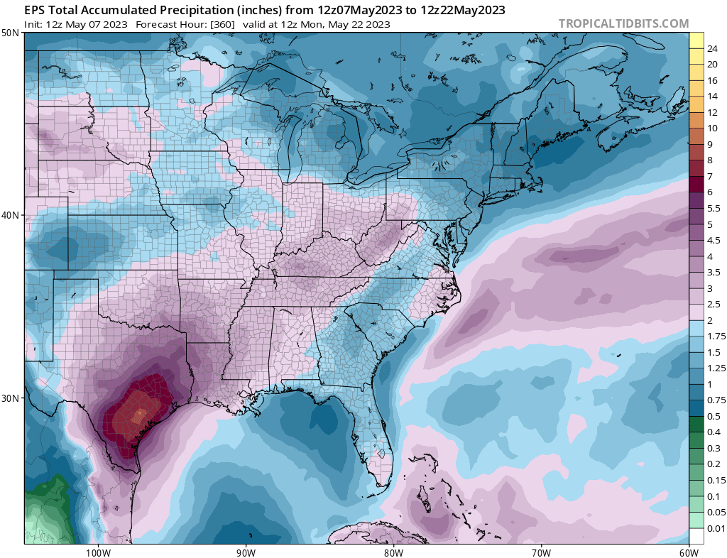
5-8” across southeast TX over the next couple weeks.
5-8” across southeast TX over the next couple weeks.
-
Stratton20
- Posts: 4281
- Joined: Tue Feb 09, 2021 11:35 pm
- Location: College Station, Texas
- Contact:
Cpv17 its been a long time since we have seen ensemble guidance put up rainfall totals like that

The 6-10 day outlooks also call for cooler than normal as well, more rainy, especially in South Texas. With a surface low, it depends on the setup. Watch for streaming Gulf moisture and rain bands on the east side.
Clouds - gotta love 'em. If only the entire summer were like this with our grass and foliage actually green going into football season!
Clouds - gotta love 'em. If only the entire summer were like this with our grass and foliage actually green going into football season!
- Attachments
-
-
-
Stratton20
- Posts: 4281
- Joined: Tue Feb 09, 2021 11:35 pm
- Location: College Station, Texas
- Contact:
18z Euro has a foot of rain in some of the western se texas counties fwiw through hour 90
-
- Information
-
Who is online
Users browsing this forum: Ahrefs [Bot], Amazon [Bot], Semrush [Bot], TexasBreeze and 273 guests