2024 Hurricane Season Discussion
Excellent discussion from Matt Lanza.
-
Stratton20
- Posts: 5430
- Joined: Tue Feb 09, 2021 11:35 pm
- Location: College Station, Texas
- Contact:
Eastern gulf needs to watch this a lot more, after looking at the ensembles and the upper air pattern, im still not really concerned about this system heading here, think our season is getting close to over
Tropical development has highest chance in the Caribbean starting next week.


-
Stormlover2020
- Posts: 546
- Joined: Mon Jun 01, 2020 6:04 pm
- Contact:
Euro aifs run isn’t good for us
Thankfully, it’s a very lonely outlier.
I just don’t see that solution coming to fruition - instinctively or meteorologically.
Then again, I’m not a professional.
-
Stormlover2020
- Posts: 546
- Joined: Mon Jun 01, 2020 6:04 pm
- Contact:
Was the best one 9 days out for last storm.. if trough doesn’t come it won’t be an outlier
-
biggerbyte
- Posts: 1405
- Joined: Thu Feb 04, 2010 12:15 am
- Location: Porter, Texas. (Montgomery County)
- Contact:
Folks, models are trending more west now. It's all about timing, but there is some potential for a major impacting Texas over to just east of Louisian.. At this time the most likely strike points would be east of Texas. The fact that we are being mentioned at all with a nasty cane involved is an eye opener..
-
Stormlover2020
- Posts: 546
- Joined: Mon Jun 01, 2020 6:04 pm
- Contact:
Euro on board
-
Stratton20
- Posts: 5430
- Joined: Tue Feb 09, 2021 11:35 pm
- Location: College Station, Texas
- Contact:
Western gulf threat is still very unlikely with this system based on the upper air pattern in the ensembles the only model thats really west right now is the euro and its AIFS, all the other guidance in in the eastern gulf, im still not concerned about this affecting texas, The euro and its AIFS will correct eastward over time
I agree. With Beryl, there were underlying concerns for our area. I don't see any underlying concerns here. Is it statistically possible we could see impacts here in SE Texas? Of course.Stratton20 wrote: ↑Wed Sep 18, 2024 1:36 pm Western gulf threat is still very unlikely with this system based on the upper air pattern in the ensembles the only model thats really west right now is the euro and its AIFS, all the other guidance in in the eastern gulf, im still not concerned about this affecting texas, The euro and its AIFS will correct eastward over time
Is it realistically possible? I highly doubt it.
Honestly, of all the models that exist, statistically, one of them will look better than others in the extended range (5+ days).Stormlover2020 wrote: ↑Wed Sep 18, 2024 11:22 am Was the best one 9 days out for last storm.. if trough doesn’t come it won’t be an outlier
Then again, they all have their moments. Even intra-season, they can look great for one storm and horrendous for another.
If you want to look at an operational model that performed superbly for Beryl, look at ICON. ICON has it at the Florida panhandle. ICON also didn't perform well for Francine. None of them really did, especially this far out.
At 9+/- days, I'm not going to worry when one ensemble (and its parent operational) shows a close call.
-
Stratton20
- Posts: 5430
- Joined: Tue Feb 09, 2021 11:35 pm
- Location: College Station, Texas
- Contact:
The reason im not buying the euro westward solution, is because it is suffering from a gravity wave BIAS, which is why its having trouble showing development east of the yucatan like what every other model shows, and 2. Its a major outlier to its own ensemble, texans dont have much to worry with this one unless something drastic changes in the upper air pattern, but that seems pretty unlikely at the moment
-
Stormlover2020
- Posts: 546
- Joined: Mon Jun 01, 2020 6:04 pm
- Contact:
Wait till u see gfs
-
TexasBreeze
- Posts: 1012
- Joined: Sun Sep 26, 2010 4:46 pm
- Location: NW Houston, TX
- Contact:
It is an eye opener and a large windfield too going towards sw LA
-
Stratton20
- Posts: 5430
- Joined: Tue Feb 09, 2021 11:35 pm
- Location: College Station, Texas
- Contact:
The 18z GEFS is still well east of the operational 18z run, they call the 18z GFS the happy hour run for a reason lol
Still doesn’t phase me. If these things are still showing on Saturday afternoon, my eyes will be open. I still don’t see it. 18z GFS runs are often notoriously wacky.
The fact it matches the ECMWF makes it less so in this instance, but unless that FROPA is now forecast to stall out or be significantly delayed, my thought process will not waver.
If anything, model runs this far out tend to always delay FROPA’s much more than what verifies.
-
biggerbyte
- Posts: 1405
- Joined: Thu Feb 04, 2010 12:15 am
- Location: Porter, Texas. (Montgomery County)
- Contact:
The AIFS has done really well this season. Both it and the GFS spell trouble for Tx/La. This is all several days away, so expect changes, or not. The GFS just yesterday was Florida, as an example.
Steering patterns look ideal for a NW to Northern Gulf landfall. Texas is on the scope of possibilities now. No expectations, but certainly precautions.
Steering patterns look ideal for a NW to Northern Gulf landfall. Texas is on the scope of possibilities now. No expectations, but certainly precautions.
Hurricanes have hit Texas in October and November.
November 1527
November 1590-Possible landfall
October 21, 1631 Hurricane
October 2-6th, 1837 Racer’s Storm
November 5, 1839 Galveston Hurricane
October 5, 1842
October 17, 1848 Hurricane
October 2-3, 1867
October 12th, 1880 Tropical Storm
October 12, 1886 Hurricane #10*
October 6, 1895 Tropical Storm #4
October 16, 1912 Hurricane #6
October 17, 1938 Tropical Storm #5
October 4, 1949 Hurricane #10*
October 15, 1989 Jerry
*Major Hurricane
https://www.wpc.ncep.noaa.gov/research/txhur.pdf
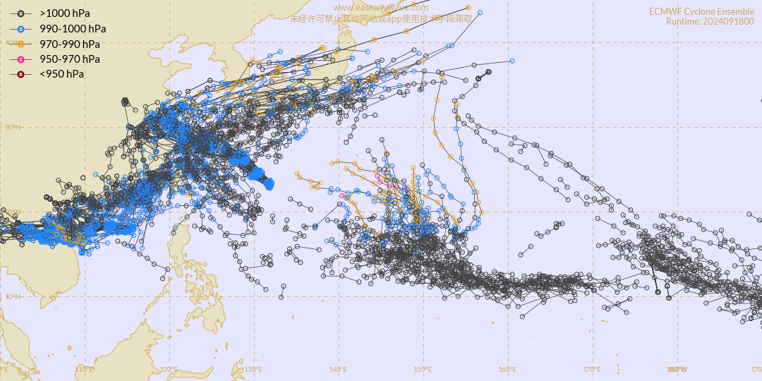
EURO Ensemble forecast for the West Pacific. West Pacific or Typhoon Basin is the most active basin in the world.


-
biggerbyte
- Posts: 1405
- Joined: Thu Feb 04, 2010 12:15 am
- Location: Porter, Texas. (Montgomery County)
- Contact:
Today is a perfect example of how we follow the chatter about potential tropical systems. The models change daily. We are closing in on getting an idea of what to expect in the Gulf over the next few days.
If you all remember, just a few days ago it looked like Armageddon was coming. Not so much Texas, but Louisiana, east, especially Florida. Now this system is showing to be a fraction of that either into Mexico or the above mentioned US states..
If you all remember, just a few days ago it looked like Armageddon was coming. Not so much Texas, but Louisiana, east, especially Florida. Now this system is showing to be a fraction of that either into Mexico or the above mentioned US states..
-
- Information
-
Who is online
Users browsing this forum: Google [Bot], Nan321Eaton, TexasBreeze and 10 guests
