
2024 Hurricane Season Discussion
-
Stratton20
- Posts: 5430
- Joined: Tue Feb 09, 2021 11:35 pm
- Location: College Station, Texas
- Contact:
I will say their is generally good agreement on ensembles on a track through the caribbean, but once the system gets into the NW caribbean, thats where the ensembles begin to diverge and split BIG TIME, alot to watch but still another very aggressive EPS run
tireman4 wrote: ↑Thu Jun 27, 2024 11:15 amAlthough he did clarify...
If it takes that track then crosses the Bay of Campeche, then I won't be needed to work. Any hint at all of a NW Gulf threat and I'll be needed for conference calls. Main uncertainty is the impact of the westerly winds aloft on the southern side of the northern Caribbean TUTT next week.
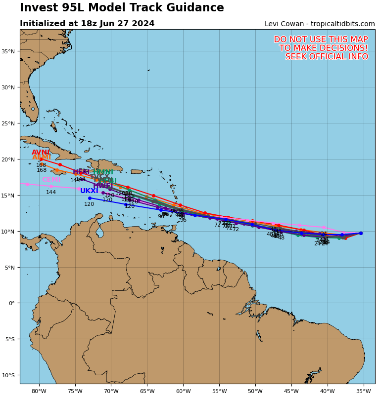
This is why I don’t believe this is going to CA. No guidance shows that. Belize to Cuba seem more likely.
-
Stratton20
- Posts: 5430
- Joined: Tue Feb 09, 2021 11:35 pm
- Location: College Station, Texas
- Contact:
Cpv17 the one model to watch for in particular is the TVCN, I believe that’s a favorite of the NHC and its pretty decent with tracks
Yep, the TVCN is solid.Stratton20 wrote: ↑Thu Jun 27, 2024 2:12 pm Cpv17 the one model to watch for in particular is the TVCN, I believe that’s a favorite of the NHC and its pretty decent with tracks
Travis Herzog just said on Facebook we should watch 95L carefully.
-
Stratton20
- Posts: 5430
- Joined: Tue Feb 09, 2021 11:35 pm
- Location: College Station, Texas
- Contact:
Cpv17 I agree, lots of variable in play, especially land interaction and how fast it ramps up, interestingly the EPS is still very aggressive

I agree 95L bears watching.
2. Eastern Tropical Atlantic (AL95):
A tropical wave located several hundred miles west-southwest of the
Cabo Verde Islands continues to produce showers and thunderstorms.
This activity is beginning to show signs of organization, and
environmental conditions are forecast to remain conducive. Thus,
further development of this system is anticipated, and a tropical
depression or tropical storm is likely to form over the next couple
of days while the system moves westward at 15 to 20 mph towards the
Windward Islands. Interests in the Lesser Antilles should monitor
the progress of this system.
* Formation chance through 48 hours...high...70 percent.
* Formation chance through 7 days...high...90 percent.
Oh boy…
-
Stratton20
- Posts: 5430
- Joined: Tue Feb 09, 2021 11:35 pm
- Location: College Station, Texas
- Contact:
Based on its presentation, we should have a TD by even later this evening, will be interesting to watch how this evolves, also interesting to note the NW movement that the GFS 18z has for the system once it clips the northern yucatan and enters the gulf
Yeah, it’s looking pretty healthy tonight and DMAX is coming up.Stratton20 wrote: ↑Thu Jun 27, 2024 7:24 pm Based on its presentation, we should have a TD by even later this evening, will be interesting to watch how this evolves, also interesting to note the NW movement that the GFS 18z has for the system once it clips the northern yucatan and enters the gulf
-
Stratton20
- Posts: 5430
- Joined: Tue Feb 09, 2021 11:35 pm
- Location: College Station, Texas
- Contact:
Cpv17 the 18z Euro came in almost 8 MB lower than its 12z run through hour 90, very interesting
Remember the stronger it gets, the more poleward it will want to go.Stratton20 wrote: ↑Thu Jun 27, 2024 9:42 pm Cpv17 the 18z Euro came in almost 8 MB lower than its 12z run through hour 90, very interesting


If hurricane was to form this early far south, it could be a sign of an active season. 1933, 2005, and 2020 come to mind.
-
biggerbyte
- Posts: 1405
- Joined: Thu Feb 04, 2010 12:15 am
- Location: Porter, Texas. (Montgomery County)
- Contact:
Folks, 95L really needs to be closely monitored. If it gains enough strength, that typical turn more north is a big concern.. Everyone from Texas to Florida, but especially Louisiana to Florida should take note. There are a few variables to consider. Sunday will be very telling.
-
Stratton20
- Posts: 5430
- Joined: Tue Feb 09, 2021 11:35 pm
- Location: College Station, Texas
- Contact:
GFS and CMC both kinda have 2 systems getting into the gulf within a few days of each other, now thats wonky!
That next system behind it is starting to get some decent ensemble support too. Crazy stuff.Stratton20 wrote: ↑Thu Jun 27, 2024 11:47 pm GFS and CMC both kinda have 2 systems getting into the gulf within a few days of each other, now thats wonky!
New lemon:
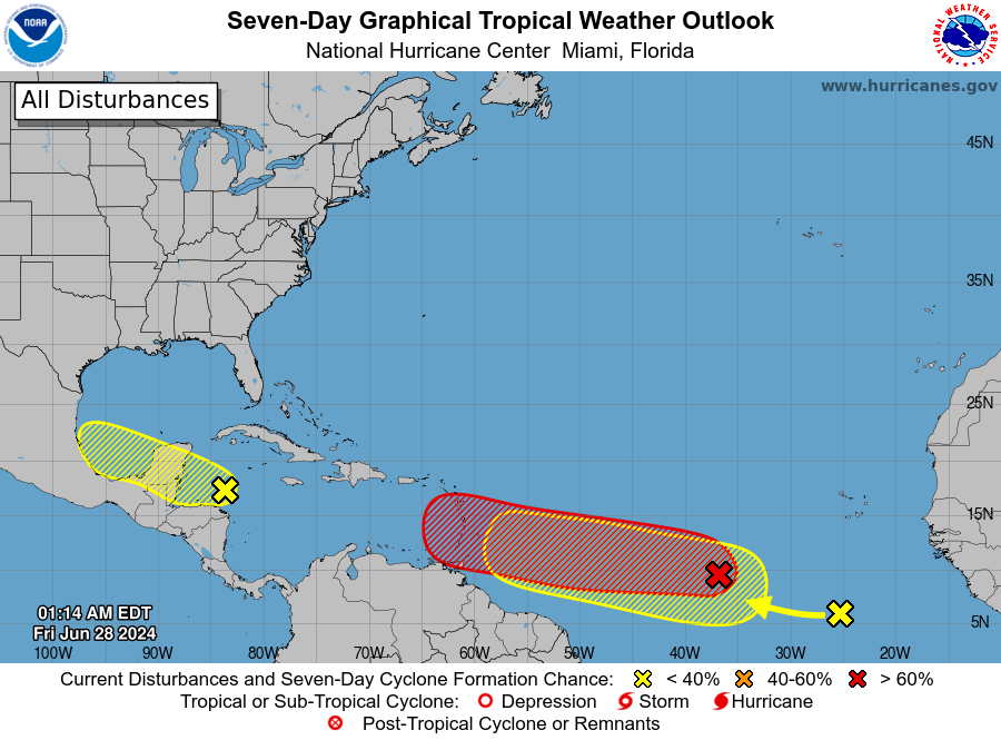
2. Central Tropical Atlantic (AL95):
Showers and thunderstorms continue to show signs of organization in
association with a tropical wave located several hundred miles
west-southwest of the Cabo Verde Islands. Environmental conditions
appear conducive for additional development, and a tropical
depression or tropical storm is likely to form over the next day or
two. This system is expected to move westward at 15 to 20 mph
towards the Windward Islands. Interests in the Lesser Antilles
should monitor the progress of this system.
* Formation chance through 48 hours...high...80 percent.
* Formation chance through 7 days...high...90 percent.
3. Eastern Tropical Atlantic:
A tropical wave centered a few hundred miles south-southwest of the
Cabo Verde Islands is producing disorganized showers and
thunderstorms. Some slow development of this system is possible
early next week while it moves generally westward across the central
and western tropical Atlantic at 15 to 20 mph.
* Formation chance through 48 hours...low...near 0 percent.
* Formation chance through 7 days...low...20 percent.
Forecaster Kelly
-
Stratton20
- Posts: 5430
- Joined: Tue Feb 09, 2021 11:35 pm
- Location: College Station, Texas
- Contact:
Cpv17 bruh! This is what all those people who made the “ cancel the season because it started slow” posts get, but yeah that one is getting support as well, what a wild week ahead!

