
Jesus Pete.....I am not at all looking forward to July/Aug/Sep/and even October at this rate if things hold up. Egads......
2024 Hurricane Season Discussion


-
Stormlover2020
- Posts: 518
- Joined: Mon Jun 01, 2020 6:04 pm
- Contact:
Ridge keeps looking stout
-
Stratton20
- Posts: 4924
- Joined: Tue Feb 09, 2021 11:35 pm
- Location: College Station, Texas
- Contact:
Stormlover2020 right now yes, that might not be the case in about 7-8 days , still a very large spread in possible outcomes
-
Stratton20
- Posts: 4924
- Joined: Tue Feb 09, 2021 11:35 pm
- Location: College Station, Texas
- Contact:
Huge shift north on the 12z CMC, went from the bay of campache to far extreme northern mexico or south texas, has a more pronounced weakness in the ridging
As of right now I have this crashing into Mexico just like every other system has done this month. I’m not too concerned about it at the moment. Till I see more ensembles and OP runs shift N, I’m going with a Belize/Yucatan, then Mexico landfall. Death ridge has a grip on Texas for now.
-
Stratton20
- Posts: 4924
- Joined: Tue Feb 09, 2021 11:35 pm
- Location: College Station, Texas
- Contact:
Really big shift north on the Euro, went from crashing into CA and just continuing westward into the pacific, now on this run, goes in land north of tampico as a cat 1 hurricane
-
Stormlover2020
- Posts: 518
- Joined: Mon Jun 01, 2020 6:04 pm
- Contact:
I know been tracking them since 1992.. also need to look at climatology and etc.. ridge has been stout stout won’t stay like that forever.. I love hurricanes so I’m ready
Model guidance appears to be pretty clustered around Honduras, Belize, El Salvador and Yucatán. A pretty high level of confidence between all of them.
Been here for years since Katrina.
-
Stratton20
- Posts: 4924
- Joined: Tue Feb 09, 2021 11:35 pm
- Location: College Station, Texas
- Contact:
sswinney confidence is good up until the yucatan peninsula/ NW caribbean , after that their is a considerable spread of scenarios
-
srainhoutx

- Site Admin

- Posts: 19673
- Joined: Tue Feb 02, 2010 2:32 pm
- Location: Maggie Valley, NC
- Contact:
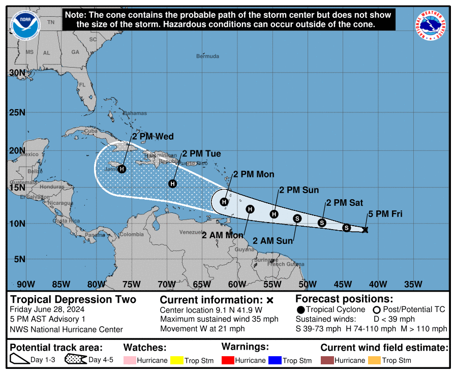
BULLETIN
Tropical Depression Two Advisory Number 1
NWS National Hurricane Center Miami FL AL022024
500 PM AST Fri Jun 28 2024
...TROPICAL DEPRESSION FORMS OVER THE CENTRAL TROPICAL ATLANTIC...
...EXPECTED TO STRENGTHEN TO A HURRICANE AS IT APPROACHES THE
WINDWARD ISLANDS...
SUMMARY OF 500 PM AST...2100 UTC...INFORMATION
----------------------------------------------
LOCATION...9.1N 41.9W
ABOUT 1225 MI...1970 KM ESE OF BARBADOS
MAXIMUM SUSTAINED WINDS...35 MPH...55 KM/H
PRESENT MOVEMENT...W OR 275 DEGREES AT 21 MPH...33 KM/H
MINIMUM CENTRAL PRESSURE...1007 MB...29.74 INCHES
WATCHES AND WARNINGS
--------------------
There are no coastal watches or warnings in effect.
Interests in the Lesser Antilles should closely monitor the
progress of this system. Hurricane and Tropical Storm Watches will
likely be required for portions of the area tonight or early
Saturday.
DISCUSSION AND OUTLOOK
----------------------
At 500 PM AST (2100 UTC), the center of Tropical Depression Two was
located near latitude 9.1 North, longitude 41.9 West. The depression
is moving toward the west near 17 mph (28 km/h). A relatively
quick westward to west-northwestward motion is expected during the
next few days. On the forecast track, the system is expected to
move across the Windward Islands late Sunday night and Monday.
Maximum sustained winds are near 35 mph (55 km/h) with higher gusts.
Steady strengthening is forecast, and the depression is expected to
become a tropical storm tonight or early Saturday and a hurricane
in a couple of days.
The estimated minimum central pressure is 1007 mb (29.74 inches).
HAZARDS AFFECTING LAND
----------------------
Key messages for Tropical Depression Two can be found in the
Tropical Cyclone Discussion under AWIPS header MIATCDAT2 and WMO
header WTNT42 KNHC.
RAINFALL: Tropical Depression Two is expected to produce rainfall
totals of 3 to 6 inches across Barbados and the Windward Islands.
This rainfall may produce localized flooding in vulnerable areas.
For a complete depiction of forecast rainfall and flash flooding
associated with Tropical Depression Two, please see the National
Weather Service Storm Total Rainfall Graphic, available at
hurricanes.gov/graphics_at2.shtml?rainqpf and the Flash Flood Risk
graphic at hurricanes.gov/graphics_at2.shtml?ero
SURF: Swells generated by the depression are expected to reach the
Windward and southern Leeward Islands by late Sunday. These swells
are likely to cause life-threatening surf and rip current
conditions. Please consult products from your local weather office.
NEXT ADVISORY
-------------
Next complete advisory at 1100 PM AST.
$$
Forecaster Cangialosi
Carla/Alicia/Jerry(In The Eye)/Michelle/Charley/Ivan/Dennis/Katrina/Rita/Wilma/Humberto/Ike/Harvey
Member: National Weather Association
Facebook.com/Weather Infinity
Twitter @WeatherInfinity
Member: National Weather Association
Facebook.com/Weather Infinity
Twitter @WeatherInfinity
I wouldn’t be surprised to see future 96L follow the same path as TD2.
-
Stratton20
- Posts: 4924
- Joined: Tue Feb 09, 2021 11:35 pm
- Location: College Station, Texas
- Contact:
Travis Herzog just said the stronger this becomes in the caribbean, the more likely it will track NW into the gulf, NHC has it peaking at a strong cat 2 and even still a strong 1 nearing jamaica, possibly could get up to a cat 3 like what some guidance suggests, a lot to watch here, but as you mentioned CPV17, 95L could possibly influence 95’s track, we shall see
Definitely looks interesting since the NHC has this near Jamaica. We’ll see if they shift the track further S. Still think this is Mexico bound, but sometimes the Euro has a tendency to overdo ridging. Maybe they got it fixed, idk.
-
Stratton20
- Posts: 4924
- Joined: Tue Feb 09, 2021 11:35 pm
- Location: College Station, Texas
- Contact:
Cpv17 looking at the euro again, as it has the system moving into the gulf, it actually starts to slide the ridge to the east, its not sitting right over texas
-
biggerbyte
- Posts: 1239
- Joined: Thu Feb 04, 2010 12:15 am
- Location: Porter, Texas. (Montgomery County)
- Contact:
We go back to the conversation about 95L/Two going south or east of Texas. We will see, but opinions have not changed since then. It looks to stay far south.
-
Stratton20
- Posts: 4924
- Joined: Tue Feb 09, 2021 11:35 pm
- Location: College Station, Texas
- Contact:
biggerbyte again its still way too early in the game here, far from set in stone
I wouldn’t completely write this off for Texas. There’s some signs that it could start to move NW near the Yucatan Peninsula after a westward motion once it reaches near Jamaica. It’s a bit too early to tell where its final destination will be, but for now smart money would be Mexico. I don’t have a lot of confidence in that right now though.
-
Stratton20
- Posts: 4924
- Joined: Tue Feb 09, 2021 11:35 pm
- Location: College Station, Texas
- Contact:
It appears the system maybe starting to show signs of rapid or at least a much faster pace of intensification, seeing some really vigorous convection firing over the center right now, its really looking healthy