
Thanks. I hope it's helpful.srainhoutx wrote: ↑Sat Jun 29, 2024 1:52 pmThere is no reason why we can't have separate threads at all. I highly encourage folks start and then update their threads to keep them timely. It certainly would make it a whole lot easier to follow different systems.Goomba wrote: ↑Sat Jun 29, 2024 1:47 pmBeryl or the one after?biggerbyte wrote: ↑Sat Jun 29, 2024 1:37 pm If this gets anywhere in the gulf and catches a ride north all bets are off. Though that scenario is still on the table, at this juncture it's not likely. This high pressure is strong and vast.
Just as things have changed since suggestions from a few days ago, I'm sure they will change again. Ike was a perfect example of it ain't done until it's done.
And just a suggestion... could we have separate threads for the different systems?
2024 Hurricane Season Discussion

A Beryl full of monkees and we're just getting started.

And the hits just keep on a comin.'

And the hits just keep on a comin.'
-
srainhoutx

- Site Admin

- Posts: 19686
- Joined: Tue Feb 02, 2010 2:32 pm
- Location: Maggie Valley, NC
- Contact:
Looks like the BoC invest is now a Tropical Storm.
Carla/Alicia/Jerry(In The Eye)/Michelle/Charley/Ivan/Dennis/Katrina/Rita/Wilma/Humberto/Ike/Harvey
Member: National Weather Association
Facebook.com/Weather Infinity
Twitter @WeatherInfinity
Member: National Weather Association
Facebook.com/Weather Infinity
Twitter @WeatherInfinity
-
srainhoutx
- Site Admin
- Posts: 19686
- Joined: Tue Feb 02, 2010 2:32 pm
- Location: Maggie Valley, NC
- Contact:
Meh, it will be inland this evening. Name burner...
Carla/Alicia/Jerry(In The Eye)/Michelle/Charley/Ivan/Dennis/Katrina/Rita/Wilma/Humberto/Ike/Harvey
Member: National Weather Association
Facebook.com/Weather Infinity
Twitter @WeatherInfinity
Member: National Weather Association
Facebook.com/Weather Infinity
Twitter @WeatherInfinity
-
tireman4

- Global Moderator

- Posts: 6253
- Joined: Wed Feb 03, 2010 9:24 pm
- Location: Humble, Texas
- Contact:
From the HGX Tropical Weather Outlook
.TROPICAL...
Issued at 350 AM CDT Mon Jul 1 2024
TS Chris is making landfall on Mexico`s Gulf Coast and is a non-issue
here. Hurricane Beryl should make its way across the Yucatan and
into the Bay of Campeche late Friday. The 00z ensembles are mostly
clustered well to our south beyond that - which is good. But as
with all long range forecasts, there are uncertainties involved.
What will Beryl look like after moving across land? What will the
shear profile look like? What is the ridging situation and
steering flow locally? Etc, etc. So really not a lot to be alarmed
about at the moment...but just keep an eye on things as the week
progresses. 47
-
tireman4
- Global Moderator
- Posts: 6253
- Joined: Wed Feb 03, 2010 9:24 pm
- Location: Humble, Texas
- Contact:
BULLETIN
Remnants Of Chris Advisory Number 4
NWS National Hurricane Center Miami FL AL032024
1000 AM CDT Mon Jul 01 2024
...CHRIS DISSIPATES OVER THE RUGGED TERRAIN OF EASTERN MEXICO...
...HEAVY RAINS CONTINUE...
SUMMARY OF 1000 AM CDT...1500 UTC...INFORMATION
-----------------------------------------------
LOCATION...20.2N 97.8W
ABOUT 60 MI...100 KM SSW OF TUXPAN MEXICO
MAXIMUM SUSTAINED WINDS...35 MPH...55 KM/H
PRESENT MOVEMENT...WNW OR 290 DEGREES AT 7 MPH...11 KM/H
MINIMUM CENTRAL PRESSURE...1007 MB...29.74 INCHES
-
tireman4
- Global Moderator
- Posts: 6253
- Joined: Wed Feb 03, 2010 9:24 pm
- Location: Humble, Texas
- Contact:
1. Central Tropical Atlantic (AL96):
Showers and thunderstorms continue in association with an area of
low pressure located over 1000 miles east-southeast of the Windward
Islands. Environmental conditions appear marginally conducive for
additional development of this system, and a tropical depression
could form by the middle part of this week while it moves generally
westward at 15 to 20 mph across the central and western tropical
Atlantic. Interests in the Lesser Antilles should monitor the
progress of this system.
* Formation chance through 48 hours...low...30 percent.
* Formation chance through 7 days...medium...60 percent.


-
tireman4
- Global Moderator
- Posts: 6253
- Joined: Wed Feb 03, 2010 9:24 pm
- Location: Humble, Texas
- Contact:
Tropical Weather Outlook
NWS National Hurricane Center Miami FL
800 AM EDT Wed Jul 3 2024
For the North Atlantic...Caribbean Sea and the Gulf of Mexico:
Active Systems:
The National Hurricane Center is issuing advisories on Hurricane
Beryl, located over the central Caribbean Sea.
1. East of the Windward Islands (AL96):
Shower and thunderstorm activity remains disorganized in association
with a tropical wave located a couple of hundred miles east of the
Windward Islands. Development, if any, of this system should be slow
to occur while it moves quickly westward to west-northwestward at
20 to 25 mph across the Caribbean Sea. Regardless of development,
gusty winds and locally heavy rainfall are possible across portions
of the Lesser Antilles today.
* Formation chance through 48 hours...low...10 percent.
* Formation chance through 7 days...low...20 percent.
Forecaster Reinhart
Already on the lookout for the next one, but no signs of any action anytime soon. Looks like a quiet couple weeks ahead.
Colorado State University latest forecast:
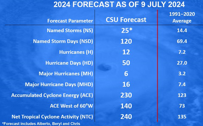
1886, 1926, 1933, 1995, 2005, 2010, 2020 are the analog years.
1886, 1926, 1933, 1995, 2005, 2010, 2020 are the analog years.
I'm afraid you're right. We have a lull for at least 2 weeks.....enough to foster complacency amongst the area's citizens (many of whom had never experienced a landfalling hurricane before).
I shudder to think of what the tropics will look like end of July and into August and September.
-
tireman4
- Global Moderator
- Posts: 6253
- Joined: Wed Feb 03, 2010 9:24 pm
- Location: Humble, Texas
- Contact:
000
ABNT20 KNHC 111116
TWOAT
Tropical Weather Outlook
NWS National Hurricane Center Miami FL
800 AM EDT Thu Jul 11 2024
For the North Atlantic...Caribbean Sea and the Gulf of Mexico:
Active Systems:
The Weather Prediction Center has issued its final advisory on
Post-Tropical Cyclone Beryl, located over southeastern Canada.
Off the Southeastern U.S. Coast:
A broad area of low pressure located a few hundred miles off the
southeastern U.S. coast continues to produce disorganized showers
and thunderstorms. Environmental conditions do not appear favorable
for much additional development of this system over the next day or
two before it moves inland over the southeastern U.S. by this
weekend. Regardless of development, heavy rainfall will be possible
for portions of the Carolina coast late this week into the weekend.
For more information about the potential for heavy rainfall, see
products issued by the Weather Prediction Center and your local
National Weather Service office.
* Formation chance through 48 hours...low...10 percent.
* Formation chance through 7 days...low...10 percent.
$$
Forecaster Papin
-
tireman4
- Global Moderator
- Posts: 6253
- Joined: Wed Feb 03, 2010 9:24 pm
- Location: Humble, Texas
- Contact:
From the Eyewall.
The three week tropical weather outlook from the Climate Prediction Center (CPC) is quite quiet for the Atlantic basin.
Tropical cyclone activity is not especially likely in the Atlantic basin for the remainder of July. (NOAA CPC)
We seem to be entering a period where dust and sinking air dominates much of the basin. Sinking air and dust tends to suppress thunderstorm growth and development. This inhibits tropical systems from forming. Most of the rising air in the background of the atmosphere is over the Pacific right now, hence why development odds seem higher in that basin, both east and west. Does that mean nothing will form? No. It’s entirely possible that something could still develop over the next 2 to 3 weeks, but it would likely be more sudden and close to home than long tracked like Beryl was. For now, let’s just enjoy the fact that quiet is expected, because it would seem to be that August will see the switch flip back to “on” for the Atlantic.
With quiet weather generally expected, we will take Friday off as we continue to have limited power and internet here in Houston. We’ll return with our next update Monday. Enjoy the weekend.
- Attachments
-
- Global Tropics Hazards Outlook.png (410.12 KiB) Viewed 4848 times