don wrote: ↑Wed Nov 29, 2023 11:44 am
Its important to note that severe weather tomorrow is conditional mainly depending on instability. Could get a mini outbreak, or just a few strong storms. Keep an eye on the mesoscale models today/tonight to get better hints of what may occur.
Regardless there will be thunderstorms tomorrow, its just a question if they will mainly be plain jane thunderstorms or supercells.
This is true. We won’t really know until about Midday tomorrow how this will ultimately go.
If I can get a half inch of rain tomorrow, I’ll consider it a success. I’m really not expecting much south of I-10. As usual, areas north of I-10 will get more action.
don wrote: ↑Wed Nov 29, 2023 11:44 am
Its important to note that severe weather tomorrow is conditional mainly depending on instability. Could get a mini outbreak, or just a few strong storms. Keep an eye on the mesoscale models today/tonight to get better hints of what may occur.
Regardless there will be thunderstorms tomorrow, its just a question if they will mainly be plain jane thunderstorms or supercells.
This is true. We won’t really know until about Midday tomorrow how this will ultimately go.
'
And that is the kicker on this. The rain may inhibit the production in the afternoon
There looks to be two rounds of storms the first round will come in the morning when the warm front moves through. And the second round will come in the afternoon as a disturbance passes through the jet stream. The storms in the afternoon will have better dynamics but there could be a lack of instability. Especially considering the first round of storms in the morning may overwork the atmosphere. There is a chance though that shear could be high enough to make up for a lack of instability. A lot of moving parts have to come together.
FWIW though the HRRR has been showing for a few runs now supercell like structures moving through the area.
Shel Winkley
@KBTXShel
·
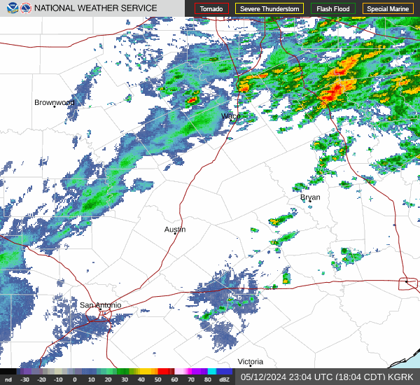
4m THURSDAY: Rain and thunderstorms are expected for the Brazos Valley. The question remains: can they tap into the dynamics for severe weather?
Highest severe weather potential currently seems focused on the eastern side of our area locally (or just to our south) /1
Shel Winkley
@KBTXShel
·
5m
/2 Important notes to consider:
•Dynamics of the day are some of the most convincing for a possible rotating/tornadic storm I've seen locally since spring (or further back)
•There are limiting factors that may stunt these storms
Ifconcern spins up, it would likely do so quickly
Well the 0Z HRRR shows a very active day tomorrow with multiple rounds of thunderstorms throughout the day. It also shows large supercells in the afternoon. ( Something to note:I've also noticed since yesterday. That the HRRR has been showing for several runs a large supercell developing along the 59 corridor in the southwest counties and moving northeast through the metro. FWIW)
While storms will be moving fast they may train over the same areas, a pattern we've seen before in these high shear setups. Some localized areas may end up getting dumped on tomorrow with several inches of rain.
The Enhanced risk was shift slightly south and now includes most of the metro area. They say the environment looks favorable for supercells starting around midday.
Day 1 Convective Outlook
NWS Storm Prediction Center Norman OK
1201 AM CST Thu Nov 30 2023
Valid 301200Z - 011200Z
...THERE IS AN ENHANCED RISK OF SEVERE THUNDERSTORMS ACROSS PARTS OF
SOUTHEAST TEXAS...
...SUMMARY...
Scattered storms with some severe, will be possible today over
southeast Texas. A few tornadoes are expected, along with hail and
isolated damaging wind gusts. Further north, into parts of east
Texas and southern Oklahoma, hail along with a few strong wind gusts
will also be possible.
...Southern Plains/Lower Mississippi Valley...
A mid-level trough will move across the Desert Southwest and
northern Mexico today. An associated 70 to 85 knot mid-level jet
will move eastward across northern Mexico and into west Texas by
this afternoon. Ahead of the mid-level jet, moisture advection will
occur across the Texas Coastal Plain. Surface dewpoints are forecast
to increase into the 65 to 70 F range from the middle Texas Coast
northward into the area west of the Houston Metro. As surface
heating takes place along and near the moist axis, MLCAPE is
forecast to increase into the 1200 to 1500 J/kg range. As the system
approaches, a 50 to 60 knot low-level jet will be maintained across
east Texas. Lift associated with the low-level jet will aid
convective development during the day over much of east Texas
extending northward into the Ark-La-Tex. A marginal severe threat
will be possible across much of this weakly unstable airmass
throughout the day.
Further south from the middle Texas Coast into Southeast Texas, the
environment will become favorable for supercells by around midday.
As surface dewpoints and low-level shear increase, Significant
Tornado Parameter is forecast to peak in the 4 to 5 range by early
to mid afternoon. RAP forecast soundings just west of Houston at 21Z
have 0-3 km storm-relative helicity reaching about 325 m2/s2. This
will likely support a tornado threat associated with supercells that
form and move into the Houston area this afternoon. A small cluster
of tornadoes is expected across southeast Texas. Although damaging
wind gusts will also be possible, this threat will be associated
with supercell downdrafts and should remain isolated. There could
also be a localized large hail threat with supercells. The potential
for severe storms could continue into the evening as a convective
cluster moves from southeast Texas into southwest Louisiana.
Area Forecast Discussion
National Weather Service Houston/Galveston TX
530 AM CST Thu Nov 30 2023
...New AVIATION...
.SYNOPSIS...
Issued at 354 AM CST Thu Nov 30 2023
Rain and thunderstorms are expected this morning and afternoon. Some
of these thunderstorms could become strong to severe. Though there
remains uncertainty regarding whether or not we will have sufficient
instability, the strong veering shear profile will create an
environment in which only modest instability could result in
isolated tornadoes. Tornadoes and damaging wind gusts are the
primary concern. Isolated large hail cannot be ruled out. In
addition, locally heavy rainfall could result in localized flooding,
particularly from I-10 south to the coast. The highest severe
weather risk will be from late morning through the afternoon.
Showers and storms could linger near the coast into the evening
hours.
&&
.SHORT TERM...
(Today through Friday Night)
Issued at 354 AM CST Thu Nov 30 2023
A negatively tilted mid/upper trough over the southwest CONUS will
push eastward today, ejecting an associated strong mid/upper jet
streak over Texas. The resulting LL cyclogenesis over NW Texas will
induce a S to SSW LL jet that will propagate eastward over our
region. Meanwhile, a surge of deep LL tropical moisture looms behind
a warm front that is pushing northward through the CWA this morning.
In addition to the large scale lift created by the primary trough,
shortwaves embedded in the mid/upper synoptic flow will introduce
additional lift to the region. In other words, there is a good
chance of showers and thunderstorms today. Given the strong
veering shear profile, we are concerned that some of these storms
could become strong to severe with the primary concerns being
tornadoes, damaging wind gusts, locally heavy rainfall, and
possibly large hail. So let`s dive into the details.
Coverage of showers and thunderstorms will increase from south to
north as an approaching shortwave enhances lift in an
increasingly moist environment. Meanwhile aloft, S to SSW 850MB
winds will continue to increase as the LL jet strengthens and
pushes eastward. By the 12Z-15Z time frame, 850MB winds could be
approaching 40 knots. RAP analysis shows elevated sfc CAPE
sneaking its way up the Texas Coast this morning. Therefore, we
cannot rule out isolated strong to severe thunderstorms pretty
early in the day over our southwestern counties near Matagorda Bay
if sufficient CAPE is able to push far enough north. Showers and
thunderstorms are possible during the morning commute elsewhere
but the highest risk of strong to severe thunderstorms will be
late morning through the afternoon and possibly lingering into the
early evening hours.
LL shear maximizes this afternoon. Bulk shear values are already
concerning enough, exceeding 50 knots this afternoon. But of
particular concern is the shear created by the 50+ knot LL jet. Fcst
soundings suggest sfc-1km shear exceeding 30 knots and possibly
exceeding 40 knots. This highly sheared and veering wind profile is
favorable for the development of supercells capable of producing a
tornado and damaging downdraft winds. The primary potential
inhibiting factors will be the morning shower and thunderstorm
activity, the lack luster lapse rates at the lowest levels, and
the potential for convection over Gulf to limit our CAPE potential
even further. Does early day rain and storms significantly
suppress later day CAPE? Do subpar LL lapse throw a wrench in our
helical updrafts? Does convection over perform offshore, depriving
inland thunderstorms of crucial energy? Or can the overall
dynamics of the system overcome these limitations? The answers to
these questions are uncertain. However, it will not take much
instability to result in isolated tornadoes today given the shear
parameters. Rain and thunderstorms will end from west to east
later today. It could take until sometime this evening for the
showers/storms to move offshore and east of our CWA. The risk of
severe weather is area wide. That being said, HREF ensembles have
been most aggressive with stronger thunderstorms between the coast
and I-10 in recent runs. It will be interesting to see if this
trend holds.
In addition to the severe weather risk, locally heavy rainfall
resulting in localized flooding will be a concern. Rainfall rates
will be high within heavier showers and thunderstorms. CAMs guidance
suggest widespread 1 to 3 inches of rainfall with locally over 6
inches possible. Though locally heavy rainfall is an area wide
concern, the best chance of seeing locally heavier totals is over
our southern and coastal counties where training cells are most
likely.
Areas of fog are possible tonight in the wake of the system. The
front is expected to stall offshore tomorrow morning before pushing
back northward, introducing another chance of showers and a few
thunderstorms on Friday. Best chance of rain on Friday will be over
our southern and coastal counties. Couldn`t rule out an isolated
stronger thunderstorm or two near the coast on Friday.
Self
&&
.LONG TERM...
(Saturday through Wednesday)
Issued at 304 AM CST Thu Nov 30 2023
With some lingering moisture possibly persisting, will keep some low
rain chances in Saturday`s forecast (higher southeast and off the
coast, lower to nil northwest and west areas). A drying airmass
(surface and high pressure building into the state) and a transition
from a southwest flow aloft to a west to northwest flow aloft will
bring dry weather back to the area will cool nights and mild days
(lows in the 40s/50s and highs in the 60s/70s) Sunday through
Wednesday.
42
&&
.AVIATION...
(12Z TAF Issuance)
Issued at 521 AM CST Thu Nov 30 2023
The primary focus today will be the high chance of SHRA/TSRA. A
few TS could become strong to severe. Latest trends support TSRA
more over our southern terminals. We no longer have TSRA
prevailing north of I-10. However, we left TSRA TEMPO groups in
all terminals north of I-10 except CLL. Primary time frame of
concern for heavy TS will be late morning through the afternoon.
We will also need to monitor wind shear, particularly near UTS
during the late morning hours. Model blend used for our wind shear
grids did not show a long enough period of shear to warrant WS in
the prevailing. But certainly something to monitor. Any heavy
TS/SH could drop cigs/vis to LIFR. Speaking of cigs, a mix of IFR
and MVFR is likely today. Given what we are seeing in the soundings,
we are leaningn towards more IFR for now. Once the TS/SH activity
moves east and offshore, the concern will shift reduced vis/cigs.
We have IFR conditions tonight but much of the guidance suggest
LIFR.
&&
.MARINE...
Issued at 304 AM CST Thu Nov 30 2023
Today is definitely not a good day for boaters to be out on the
waters. Strengthening onshore winds and building seas are expected
today as a storm system organizes and moves across the state. Buoy
42019 has southeast winds increasing early this morning with gusts
close to 30 knots, and similar speeds should spread closer to the
coast/bays as the day progresses today. Small Craft Advisories and
Gale Warnings will be in effect as seas rise to 6 to 9 feet
nearshore and 10 to 14 feet offshore while winds gusts up to gale
force. These hazardous marine conditions could linger into the late
evening and possibly into parts of the overnight hours before the
gradient starts to relax resulting in lowering winds and seas.
Periods of showers and thunderstorms can be expected too with some
storms possibly becoming strong or severe. With the storm system`s
front expected to stall somewhere near/along the coast, we could see
some fog development in a late Thursday night through Saturday time
period. Conditions will improve over the weekend and into the start
of next week as the offshore flow weakens and seas come down.
42
&&
.CLIMATE...
Issued at 304 AM CST Thu Nov 30 2023
Here are today`s rainfall records (11/30) for our five major climate
sites.
CLL - 1.91 inches set in 1968
IAH - 1.41 inches set in 1968
HOU - 1.05 inches set in 1982
GLS - 1.40 inches set in 1921
PSX - 1.28 inches set in 1968
don wrote: ↑Wed Nov 29, 2023 9:48 pm
Well the 0Z HRRR shows a very active day tomorrow with multiple rounds of thunderstorms throughout the day. It also shows large supercells in the afternoon. ( Something to note:I've also noticed since yesterday. That the HRRR has been showing for several runs a large supercell developing along the 59 corridor in the southwest counties and moving northeast through the metro. FWIW)
While storms will be moving fast they may train over the same areas, a pattern we've seen before in these high shear setups. Some localized areas may end up getting dumped on tomorrow with several inches of rain.
Overnight runs of the HRRR trended a lot drier and more focused on the coastal areas.
I think the cloud cover will help add some stability to the atmosphere, while the threat of some big thunderstorms popping up in the afternoon still exists, I think the threat is definitely lower than what models were showing a few days ago
Pat Cavlin
@pcavlin
For those doubting the potential for severe weather based on marginal CAPE values, I would direct you to research done by Guyer & Dean from the SPC
Low CAPE/high shear events are VERY common this time of year in the South and can still yield significant storms 🧵
Again - this setup isn't a slam dunk, but the atmosphere is able to do so much with so little. Even CAPE values ~500 are sufficient to sustain severe storms in the right environment with shear (2/)
They conclude: ".....this study reinforces previous findings that tornadoes, including significant tornadoes, can and do occur within weak buoyancy regimes, and that measures of CAPE alone can be poor discriminators of tornado likelihood and intensity."


 TORNADO THREAT -


 THURSDAY: Rain and thunderstorms are expected for the Brazos Valley. The question remains: can they tap into the dynamics for severe weather?


