

Light the candle!jasons2k wrote: ↑Sat Apr 20, 2024 1:35 pmYou can see it advancing on satellite. Things are about to go boom! between your place and mine.DoctorMu wrote: ↑Sat Apr 20, 2024 1:29 pm The dryline/front just blasted through. DP at 66°F and tanking. Brisk northerlies and heavy cloud. there's plenty of moisture aloft. I'm hoping for 2-3 inches of the liquid gold.
We've had only 0.83 inches of rain in April. I'd like to shut down the sprinklers and A/C for awhile.
April 2024

I’m getting a good shower now.
There is a mesoscale discussion up…
https://www.spc.noaa.gov/products/md/md0499.html
There is a mesoscale discussion up…
https://www.spc.noaa.gov/products/md/md0499.html
A flood watch begins at 4pm for the NW half of SE Texas:
Flood Watch
National Weather Service Houston/Galveston TX
1115 AM CDT Sat Apr 20 2024
TXZ163-164-176>179-195>199-210>212-210900-
/O.NEW.KHGX.FA.A.0002.240420T2100Z-240421T0900Z/
/00000.0.ER.000000T0000Z.000000T0000Z.000000T0000Z.OO/
Houston-Trinity-Madison-Walker-San Jacinto-Polk-Burleson-Brazos-
Washington-Grimes-Montgomery-Colorado-Austin-Waller-
Including the cities of Corrigan, Columbus, Conroe, Trinity,
Huntsville, Shepherd, Somerville, Prairie View, College Station,
Groveton, Bellville, Livingston, The Woodlands, Crockett,
Coldspring, Brookshire, Navasota, Eagle Lake, Weimar, Brenham,
Sealy, Bryan, Hempstead, Waller, Caldwell, and Madisonville
1115 AM CDT Sat Apr 20 2024
...FLOOD WATCH IN EFFECT FROM 4 PM CDT THIS AFTERNOON THROUGH LATE
TONIGHT...
* WHAT...Flooding caused by excessive rainfall is possible.
* WHERE...A portion of southeast Texas, including the following
counties, Austin, Brazos, Burleson, Colorado, Grimes, Houston,
Madison, Montgomery, Polk, San Jacinto, Trinity, Walker, Waller
and Washington.
* WHEN...From 4 PM CDT this afternoon through late tonight.
* IMPACTS...Excessive runoff may result in flooding of rivers,
creeks, streams, and other low-lying and flood-prone locations.
Flooding may occur in poor drainage and urban areas.
* ADDITIONAL DETAILS...
- Numerous showers, heavy at times, and scattered thunderstorms
are expected late this afternoon through the overnight hours.
The greatest potential for excessive rainfall will be roughly
along and north of line from Columbus to Brookshire to The
Woodlands to Livingston. Widespread totals of 2 to 4 inches
are expected over these areas. Isolated higher amounts of 5
to 7 inches are possible where training of showers and
thunderstorms occurs.
- http://www.weather.gov/safety/flood
PRECAUTIONARY/PREPAREDNESS ACTIONS...
You should monitor later forecasts and be alert for possible Flood
Warnings. Those living in areas prone to flooding should be prepared
to take action should flooding develop.
- Attachments
-
- IMG_1065.png (561.06 KiB) Viewed 487 times
Hope this is more progressive. Don't expect to get much of anything.
And updated Mesoscale Discussion was issued earlier:
Mesoscale Discussion 0499
NWS Storm Prediction Center Norman OK
0136 PM CDT Sat Apr 20 2024
Areas affected...Texas Coastal Plain into Southeast TX
Concerning...Severe potential...Watch unlikely
Valid 201836Z - 202100Z
Probability of Watch Issuance...20 percent
SUMMARY...Widespread thunderstorms are expected from the Texas
Coastal Plain into Southeast TX this afternoon. Isolated strong to
severe thunderstorms are possible, with hail to 1" in diameter and
damaging gusts from 45 to 55 mph as the primary hazards.
DISCUSSION...A cold front continues to push slowly south across
central and east TX, aided by a widespread showers and thunderstorms
from southwest TX through north-central and into northeast TX. Warm
and moist southerly low-level flow has persisted throughout the
morning and into to early afternoon. This has resulted in increased
low-level convergence along the front zone while also destabilizing
the downstream air mass. Pre-frontal dewpoints now range from the
upper 60s across the TX Hill Country to the low 70s across the TX
Coastal Plain into southeast TX. Additionally, filtered heating has
allowed temperatures to rise into the low 80s. These low-level
thermodynamic conditions have resulted in air mass destabilization,
with mesoanalysis recently estimating that convective inhibition has
eroded. Additionally, these warm and moist conditions are
contributing to moderate buoyancy (i.e. around 1500 J/kg) despite
relatively poor mid-level lapse rates.
General expectation is for thunderstorm coverage to increase this
afternoon along and ahead of the front. Widespread coverage should
limit storm discreteness while boundary-parallel deep-layer vertical
shear favors multicell clusters. Even so, Given the moderate
buoyancy and shear, a few stronger storms are possible. The
strongest storms may be able to produce hail up to around 1". A few
water-loaded downbursts from 45 to 55 mph are possible as well.
..Mosier/Goss.. 04/20/2024
...Please see www.spc.noaa.gov for graphic product...
ATTN...WFO...LCH...HGX...CRP...EWX...

- canvfas.png (719.92 KiB) Viewed 458 times
This front just passed my house. Wind switched to the north with a drop in the dew point. You can see it on the blue line, on the TIAH radar.
- Attachments
-
- IMG_1066.png (1.9 MiB) Viewed 458 times
-
srainhoutx

- Site Admin

- Posts: 19616
- Joined: Tue Feb 02, 2010 2:32 pm
- Location: Maggie Valley, NC
- Contact:
Mesoscale Precipitation Discussion 0166
NWS Weather Prediction Center College Park MD
404 PM EDT Sat Apr 20 2024
Areas affected...South-Central through Eastern Texas
Concerning...Heavy rainfall...Flash flooding possible
Valid 202003Z - 210200Z
Summary...Showers and thunderstorms expanding across portions of
eastern Texas this afternoon will intensify through the evening
and begin to train to the northeast. Rainfall rates of 1-2"/hr,
possibly higher at times, are expected within this strengthening
convection. This will result in 2-3" of rain with locally higher
amounts up to 5", possibly resulting in instances of flash
flooding.
Discussion...The regional radar mosaic this afternoon indicates a
rapid expansion of showers and thunderstorms across eastern Texas
from near the LA/TX border southwest through portions of
south-central Texas. Rainfall rates within this fresh convection
have been estimated via local WSR-88Ds to be up to 1"/hr already,
with regional mesonet observations measuring as much as 1/3 of an
inch in 20 minutes. This development is being fueled by a
combination of synoptic ascent through increasing upper diffluence
in the tail of a 130kt upper jet streak, modest PVA in the
vicinity of weak mid-level impulses moving through the flow across
TX, and increasingly impressive low-level convergence along the
front. Additionally, some isentropic upglide is occurring as the
925-850mb flow surges out of the Gulf of Mexico and atop the
stationary boundary. This deep layer ascent is working upon a
favorable thermodynamic environment for heavy rain characterized
by PWs as high as 1.8", around the 90th% according to the SPC
sounding climatology, and MUCAPE above 3000 J/kg.
As the afternoon progresses, the high-res guidance is very
consistent depicting a strong signal for an expansion of heavy
rainfall across this area. Recent runs of the HRRR, ARW, and ARW2
all indicate that an axis of heavy rain will develop along and
just north of this stationary front, likely responding to the
persistent mesoscale ascent occurring there in the otherwise
pronounced synoptic lift. Mean 850-300mb winds are progged to
remain progressive at 20-30 kts, but will also be favorable
aligned with the Corfidi vectors, suggesting an enhanced training
threat as storms build back into the greater instability and lift
ENE. With rain rates likely peaking above 2"/hr at times as
reflected by both HREF neighborhood probabilities and the HRRR
sub-hourly fields, this will likely cause stripes of 2-3" of rain,
with locally as much as 5" possible noted by HREF 54"/6hr
neighborhood probabilities reaching 20-30%.
FFG across the region is quite high at generally 3"/1hr and
4"/3hrs, which is responsible for capping HREF FFG exceedance
probabilities at just 20-30%. However, there is an axis of higher
40cm soil moisture noted via NASA SPoRT from just west of Houston
up towards the ArkLaTex. While flash flooding is possible in most
areas where these heavy rain rates train most efficiently,
instances are most likely should the rain fall across these more
saturated soils.
Weiss
ATTN...WFO...CRP...EWX...FWD...HGX...LCH...SHV...
- GLoj03paIAASMn7.jpeg (72.39 KiB) Viewed 452 times
Carla/Alicia/Jerry(In The Eye)/Michelle/Charley/Ivan/Dennis/Katrina/Rita/Wilma/Humberto/Ike/Harvey
Member: National Weather Association
Facebook.com/Weather Infinity
Twitter @WeatherInfinity
Member: National Weather Association
Facebook.com/Weather Infinity
Twitter @WeatherInfinity
0.62 inches so far. Not bad, some of the steadiest rain since January. The streamer showers are expanding to a little south of I-10.
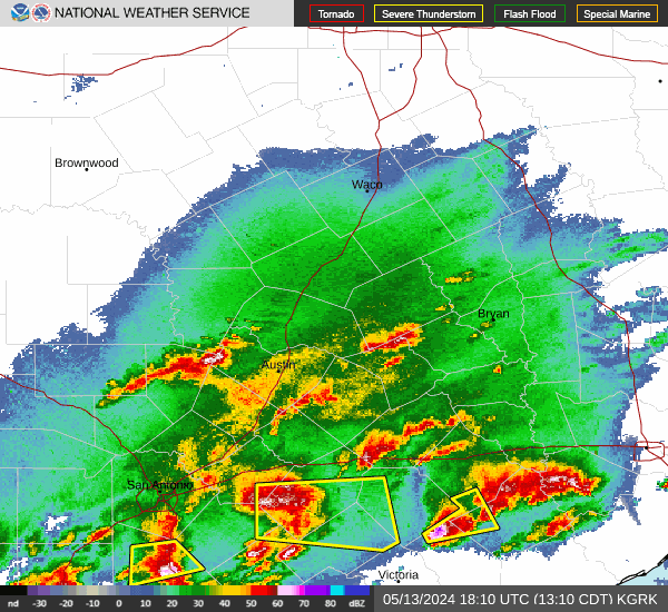
The big stuff is approaching Waco and the Hill Country.
The big stuff is approaching Waco and the Hill Country.
Things appear to be ramping up:
Dud. Not even a threat of a sprinkle and unlikely to change.
-
Stratton20
- Posts: 4259
- Joined: Tue Feb 09, 2021 11:35 pm
- Location: College Station, Texas
- Contact:
Meh, looks like a miss to the north, that activity will probably by pass a good chunk of SE texas to the north, really unfortunate
No worries - you all will have more wins from late May - September.
It's a gullywasher up in CLL. We just barely made it back from HEB and the Rx before the 2 inch/hour stuff came down. There was some road ponding and I'd expect some local flooding.
It's a gullywasher up in CLL. We just barely made it back from HEB and the Rx before the 2 inch/hour stuff came down. There was some road ponding and I'd expect some local flooding.
Spicy up in B/CS area…
- Attachments
-
- IMG_1072.jpeg (2.83 MiB) Viewed 326 times
Front now along BW8 South. Will be watching for new storms in the LLJ.
- Attachments
-
- IMG_1073.png (1.71 MiB) Viewed 325 times
I think therte were be rain south of I-10 later tonight. The secondary system is sagging south,
0.00 for all of 2023 May - September
Chipotle style.
There was quite a bit of lightning. Maybe this will put it out.
2.98 inches of rain IMFY so far. This has to be the most rain in CLL from a storm system since May 2023. Maybe before.
Flood Advisory issued April 20 at 7:19PM CDT until April 20 at 10:15PM CDT by NWS Houston/Galveston TX
* WHAT...Urban and small stream flooding caused by excessive
rainfall is expected.
* WHERE...A portion of southeast Texas, including the following
counties, Brazos, Burleson and Grimes.
* WHEN...Until 1015 PM CDT.
* IMPACTS...Minor flooding in low-lying and poor drainage areas.
* ADDITIONAL DETAILS...
- At 719 PM CDT, Doppler radar indicated heavy rain due to
thunderstorms. This will cause urban and small stream
flooding. Between 1 and 2 inches of rain have fallen.
- Additional rainfall amounts of 1 to 3 inches are expected
over the area. This additional rain will result in minor
flooding.
- Some locations that will experience flooding include...
College Station, Bryan, Millican, Kyle Field and Wellborn.
- http://www.weather.gov/safety/flood
Instructions
Turn around, don't drown when encountering flooded roads. Most flood
deaths occur in vehicles.
Please report observed flooding to local emergency services or law
enforcement and request they pass this information to the National
Weather Service when you can do so safely.
Sender NWS Houston/Galveston TX
Sent 4/20/2024 19:19 CDT