


Sorry. My bad.wxman57 wrote:That was the February 2010 forecast up above, Ptarmigin. Here's the February 2011 forecast. It has changed significantly from the January outlook for MJJ in that it's now forecasting normal pressures in the Subtropical and Tropical Atlantic and lower pressures over the U.S. That could mean a stronger Bermuda High and less storms recurving east of the U.S. Here's the current JJA forecast:
http://www.ecmwf.int/products/forecasts ... !chart.gif
2011 ATL Hurricane Season: Coming to an End
-
srainhoutx

- Site Admin

- Posts: 19616
- Joined: Tue Feb 02, 2010 2:32 pm
- Location: Maggie Valley, NC
- Contact:
As we begin to transition toward tropical season, one has to wonder if a stronger Bermuda Ridge in ahead. If we see a neutral/positive NAO ( SE Ridge ), the door could open for some early season activity in our part of the Basin. Early indications suggest a weakening La Nina meaning another active year. Unlike last year, we may need to keep an eye closer to home, IMO.
Carla/Alicia/Jerry(In The Eye)/Michelle/Charley/Ivan/Dennis/Katrina/Rita/Wilma/Humberto/Ike/Harvey
Member: National Weather Association
Facebook.com/Weather Infinity
Twitter @WeatherInfinity
Member: National Weather Association
Facebook.com/Weather Infinity
Twitter @WeatherInfinity
-
desiredwxgd
- Posts: 125
- Joined: Wed Feb 03, 2010 6:30 pm
- Location: TX/LA/Southern New England
- Contact:
After a long winter’s hibernation I return to what looks to be yet another “exciting” season.
JMS
SR. ENSC.
SR. ENSC.

yes it is Andrew and we are just in March.....quite the rebound.....you know we are getting close when you see the LC already supporting a cat 5......lol
http://wxmaps.org/pix/hurpot.html#ATL
http://wxmaps.org/pix/hurpot.html#ATL
-
srainhoutx
- Site Admin
- Posts: 19616
- Joined: Tue Feb 02, 2010 2:32 pm
- Location: Maggie Valley, NC
- Contact:
Report issued today by the CPC suggests neutral La Nina conditions for May/June/July. Interesting that they also suggest a possible return to El Nino conditions for the late summer/fall timeframe. Perhaps an early start and an early ending of Tropical Season? We will see...
http://www.cpc.ncep.noaa.gov/products/a ... ts-web.pdf•Nearly all models indicate that La Niña will weaken in the coming months.
•A majority of models and all three multi-model forecasts indicate ENSO-neutral conditions by May-June-July 2011 (Niño-3.4 SST anomalies between -0.5C and +0.5C ).
Carla/Alicia/Jerry(In The Eye)/Michelle/Charley/Ivan/Dennis/Katrina/Rita/Wilma/Humberto/Ike/Harvey
Member: National Weather Association
Facebook.com/Weather Infinity
Twitter @WeatherInfinity
Member: National Weather Association
Facebook.com/Weather Infinity
Twitter @WeatherInfinity
-
wxman57

- Global Moderator

- Posts: 2621
- Joined: Thu Feb 04, 2010 5:34 am
- Location: Southwest Houston (Westbury)
- Contact:
Quite a change over the past few weeks. Nearing El Nino by October now. Not the current rate of warming that's forecast to slow down immediately. Will it? Or will the season be shut down in October by an oncoming El Nino? It takes 3 months of SSTs over +0.5C to make an El Nino, so likely no El Nino this season. But a spike of warmth late in the season might shut down activity in October.
February 13th:
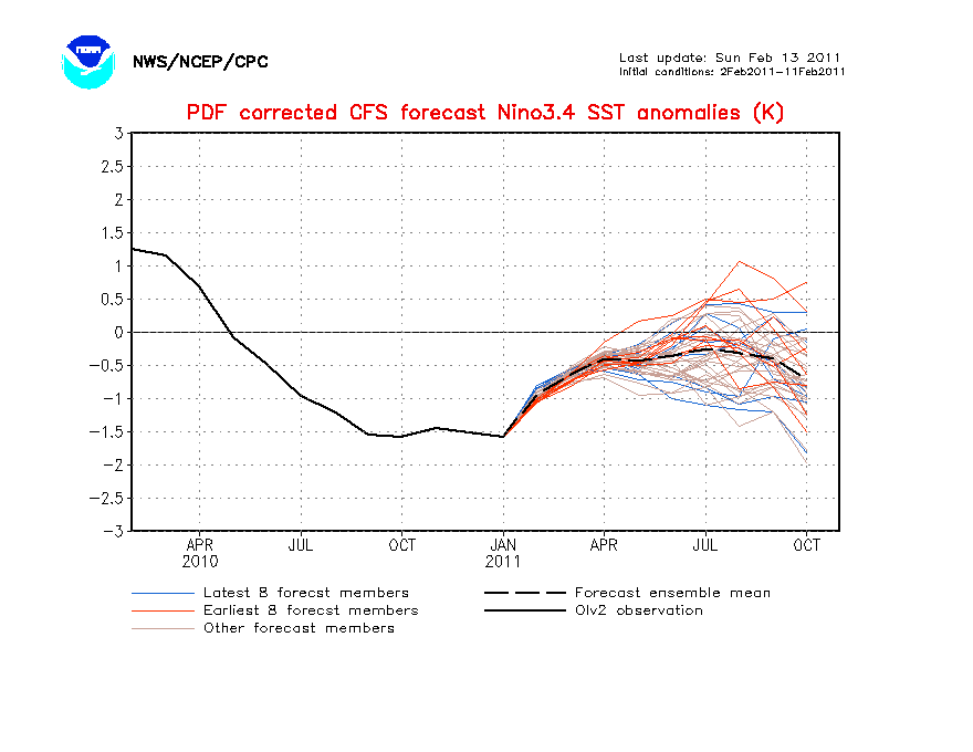
Current:
February 13th:
Current:
For all intents and purposes, I consider Ike a major because of the damage it wrought on.Ed Mahmoud wrote:The vast majority of seasons, barelycane Jerry and the 1949 Freeport storms as exceptions, its all over by the Autumnal Equinox anyway.
I'm not anti-hurricane by any means, I wouldn't mind a Carla experience, as long as it comes at the right time. I know people with property in Galveston. I enjoy visiting.
Giving Cat 2 Ike credit for being a major, even though it wasn't, 1983 to 2008, I'll be prepared for a big one in HGX around 2030. Kids will be grown. Probably surf the internet and watch TV all day until the power goes out. Maybe upload whatever the 2030 version of U-Tube video is. Maybe I'll spend thousands for a generator and an electrician for something that gets used more than an hour at a time once a decade by then so I can keep surfing.
-
wxman57
- Global Moderator
- Posts: 2621
- Joined: Thu Feb 04, 2010 5:34 am
- Location: Southwest Houston (Westbury)
- Contact:
The term "major hurricane" means that the hurricane had 111 mph sustained winds or greater, nothing else. One could argue that Ike was almost a major hurricane at landfall with 110 mph winds, but that 110 mph was probably an over-estimate as no such surface winds were measured. Ike's max sustained winds were probably closer to 100-105 mph. Therefore, Ike was definitely NOT a major hurricane as far as the exact definition of "major hurricane".
I would argue that the term "intense hurricane" is more appropriate to use for Saffir-Simpson category 3-4-5 hurricanes, as "intense" relates only to the max sustained wind and not to the extent of damage across the landfall region. Many intense hurricanes would prove to be major hurricanes in terms of the extent of damage, but so would less intense hurricanes like Ike or Gustav, or Isabel in NC/VA/MD. Even remnant low Allison of 2001 caused major damage.
Bottom line - don't confuse the "major" in "major hurricane" with implied or observed damage, as it's just an indication of the hurricane's max sustained winds. And these max winds may cover only a few square miles in tiny hurricanes.
-
srainhoutx
- Site Admin
- Posts: 19616
- Joined: Tue Feb 02, 2010 2:32 pm
- Location: Maggie Valley, NC
- Contact:
The young Dr. Klotzbach and Dr. Gray of CSU fame are scheduled to release another Tropical Season Update for 2011 on April 6th. It will be interesting to see if the December numbers they predicted hold as well as those ominous analog years that raised an eyebrow.
Carla/Alicia/Jerry(In The Eye)/Michelle/Charley/Ivan/Dennis/Katrina/Rita/Wilma/Humberto/Ike/Harvey
Member: National Weather Association
Facebook.com/Weather Infinity
Twitter @WeatherInfinity
Member: National Weather Association
Facebook.com/Weather Infinity
Twitter @WeatherInfinity
-
wxman57
- Global Moderator
- Posts: 2621
- Joined: Thu Feb 04, 2010 5:34 am
- Location: Southwest Houston (Westbury)
- Contact:
I think he'll lower his prediction by 1, down to 16. And possibly lower it again by the start of the season. New Euro forecast is for higher pressures in the Atlantic, indicating a stronger Bermuda High. That means greater low-level wind shear (not strong, just greater). Actually, very similar to 2008. Fewer storms than 2010 but a greater landfall risk due to the more westerly movement (stronger Bermuda High).
I'm leaning toward 14-15 named storms this season (down from 19 in 2010). Analog years suggest an increased risk to TX/LA and the Carolinas. Greatest risk would be to the islands of the NE Caribbean.
Euro forecast for July-September 2011 Just Issued:

Same forecast from March 2010:

I'm leaning toward 14-15 named storms this season (down from 19 in 2010). Analog years suggest an increased risk to TX/LA and the Carolinas. Greatest risk would be to the islands of the NE Caribbean.
Euro forecast for July-September 2011 Just Issued:
Same forecast from March 2010:
Season that occur in transition seem to be more active I have noticed. I don't think this season will be as active as 2010, but it will be active. I think a good analog season are 1961, 1969, 1989, and 2008.
-
srainhoutx
- Site Admin
- Posts: 19616
- Joined: Tue Feb 02, 2010 2:32 pm
- Location: Maggie Valley, NC
- Contact:
CPC ENSO Update suggests a nuetral La Nina by June. Some very interesting analogs continue to show up as well.
http://www.cpc.ncep.noaa.gov/products/a ... ts-web.pdfSummary
•La Niña is present across the equatorial Pacific, but continues to weaken.
•Negative subsurface and sea surface temperature anomalies also continue to weaken across the Pacific Ocean.
•ENSO-neutral conditions are expected by June 2011.
Carla/Alicia/Jerry(In The Eye)/Michelle/Charley/Ivan/Dennis/Katrina/Rita/Wilma/Humberto/Ike/Harvey
Member: National Weather Association
Facebook.com/Weather Infinity
Twitter @WeatherInfinity
Member: National Weather Association
Facebook.com/Weather Infinity
Twitter @WeatherInfinity
-
srainhoutx
- Site Admin
- Posts: 19616
- Joined: Tue Feb 02, 2010 2:32 pm
- Location: Maggie Valley, NC
- Contact:
Accuweather thoughts include early season threats to TX...
http://www.accuweather.com/blogs/news/s ... season.asp
http://www.accuweather.com/blogs/news/s ... season.asp
Carla/Alicia/Jerry(In The Eye)/Michelle/Charley/Ivan/Dennis/Katrina/Rita/Wilma/Humberto/Ike/Harvey
Member: National Weather Association
Facebook.com/Weather Infinity
Twitter @WeatherInfinity
Member: National Weather Association
Facebook.com/Weather Infinity
Twitter @WeatherInfinity
-
wxman57
- Global Moderator
- Posts: 2621
- Joined: Thu Feb 04, 2010 5:34 am
- Location: Southwest Houston (Westbury)
- Contact:
I can't find that blog posting, srain. What date did he post it?srainhoutx wrote:JB seems to like 1996 1999 2005 and 2008 analogs...
http://www.weatherbell.com/jb/?paged=2
Edit: Found it - http://www.weatherbell.com/jb/?paged=3
He wasn't necessarily referring to those years as the best analogs for hurricane season, just that there was a similar ENSO trend in April of those years. But I do agree that 2008 looks to be the best analog so far for the 2011 season.
-
srainhoutx
- Site Admin
- Posts: 19616
- Joined: Tue Feb 02, 2010 2:32 pm
- Location: Maggie Valley, NC
- Contact:
I'll bump this a day early. The Update is due out tomorrow...srainhoutx wrote:The young Dr. Klotzbach and Dr. Gray of CSU fame are scheduled to release another Tropical Season Update for 2011 on April 6th. It will be interesting to see if the December numbers they predicted hold as well as those ominous analog years that raised an eyebrow.
http://typhoon.atmos.colostate.edu/Incl ... edule.html
Carla/Alicia/Jerry(In The Eye)/Michelle/Charley/Ivan/Dennis/Katrina/Rita/Wilma/Humberto/Ike/Harvey
Member: National Weather Association
Facebook.com/Weather Infinity
Twitter @WeatherInfinity
Member: National Weather Association
Facebook.com/Weather Infinity
Twitter @WeatherInfinity
-
wxman57
- Global Moderator
- Posts: 2621
- Joined: Thu Feb 04, 2010 5:34 am
- Location: Southwest Houston (Westbury)
- Contact:
Thanks, I'd forgotten that Phil was going to update his forecast tomorrow. I predict he'll lower his numbers of 17-9-5 to 16-8-4 on this update. He may end up with only 14 or 15 named storms forecast by the time June rolls around.
-
wxman57
- Global Moderator
- Posts: 2621
- Joined: Thu Feb 04, 2010 5:34 am
- Location: Southwest Houston (Westbury)
- Contact:
April update is out. He reduced the numbers to 16/9/5 (from 17/9/5):
http://hurricane.atmos.colostate.edu/Fo ... pr2011.pdf
Best analog years 1955, 1996, 1999 and 2008. 2006 was listed as an analog, but an El Nino developed during the peak of the season, something that's not likely this season. I still think 14-15 named storms may be more likely.
http://hurricane.atmos.colostate.edu/Fo ... pr2011.pdf
Best analog years 1955, 1996, 1999 and 2008. 2006 was listed as an analog, but an El Nino developed during the peak of the season, something that's not likely this season. I still think 14-15 named storms may be more likely.