
July 2024

I heard the tropics may start to get interesting in July. Don't know if that's credible or just talk.
Interesting update today from the CPC:
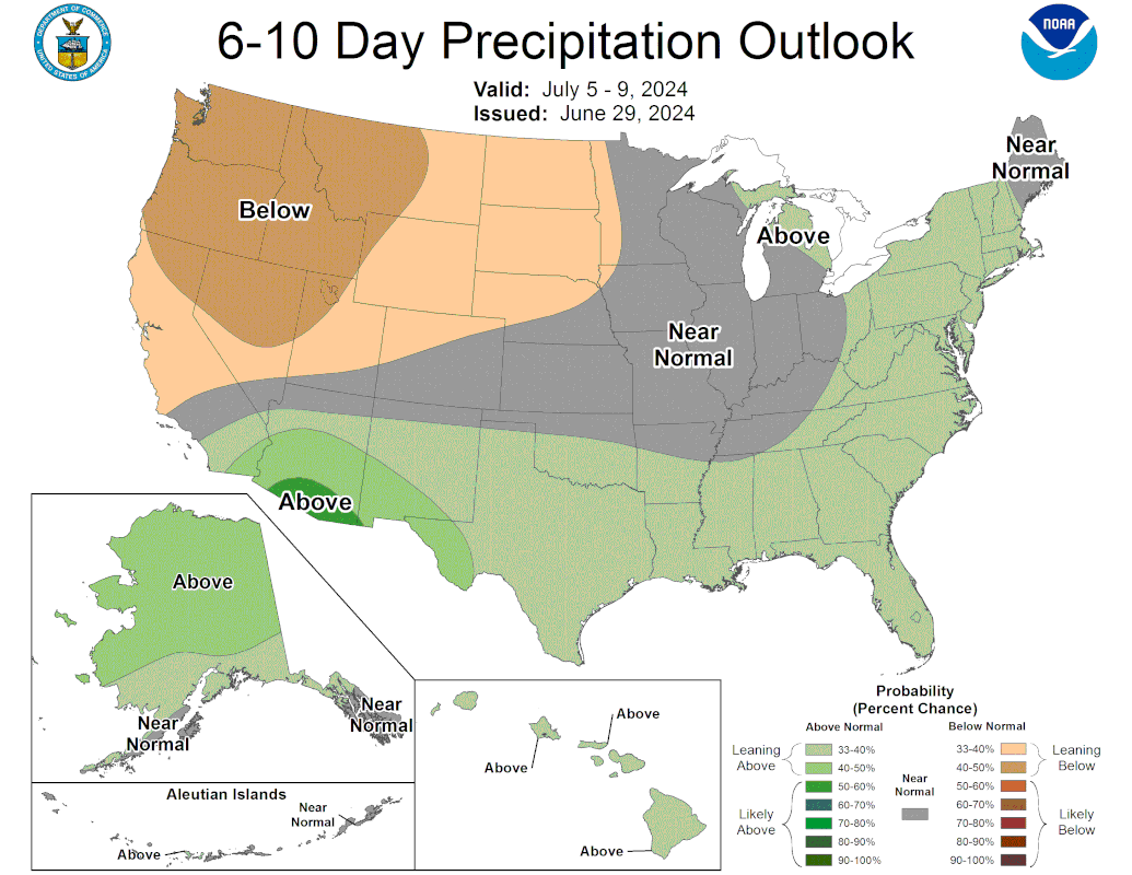
This could mean ridging backing off.
This could mean ridging backing off.
-
tireman4

- Global Moderator

- Posts: 6250
- Joined: Wed Feb 03, 2010 9:24 pm
- Location: Humble, Texas
- Contact:
696
FXUS64 KHGX 011138
AFDHGX
Area Forecast Discussion
National Weather Service Houston/Galveston TX
638 AM CDT Mon Jul 1 2024
...New AVIATION...
.SHORT TERM...
(Today through Tuesday Night)
Issued at 350 AM CDT Mon Jul 1 2024
Surface high pressure will remain overhead through the short-term
period and will allow the streak of hot and humid conditions to
persist. A Heat Advisory will continue to be in effect through this
evening as highs in the upper 90s combine with dew point values in
the upper 70s to near 80 and result in heat indices in the 105-100F
range for much of the area.
Showers and storms will be possible again this afternoon and Tuesday
afternoon courtesy of a weak boundary. Rainfall totals of less than
a tenth of an inch expected.
Overnight lows will not provide much relief from today`s unrelenting
heat. Temperatures will be in the upper 70s inland to the low 80s
along the coast. Continue to practice heat safety, and remember to
look before you lock!
Adams
&&
.LONG TERM...
(Wednesday through Sunday)
Issued at 350 AM CDT Mon Jul 1 2024
Mid-upper ridging will keep things about status quo into the late
work week with hot & muggy conditions prevailing. A select few
might see an isolated diurnally driven shra/tstm, but overall
chances remain fairly slim.
Friday into the weekend, the ridge loses some of its grip across the
area as it shifts eastward and a trof makes its way into the
Plains. Temperatures should still be slightly above normal and
uncomfortable as this occurs...just less miserable as we`re currently
experiencing. What it should do however, is provide a somewhat less
hostile profile aloft and allow for a touch more iso-sct precip
coverage. 47
&&
.AVIATION...
(12Z TAF Issuance)
Issued at 631 AM CDT Mon Jul 1 2024
LBX experiencing IFR VSBYs. All other sites at VFR. Expect VFR to
prevail through the period at all sites. LBX should reutrn to VFR
by the afternoon. Showers and thunderstorms will be possible this
afternoon through the evening hours. Winds will generally be
light and variable this morning, becoming light out of the S-SW
this afternoon.
&&
.MARINE...
Issued at 350 AM CDT Mon Jul 1 2024
Look for a gradual decay in the 3-5ft longer period swell associated
with TS Chris well to our south as the day progresses. High
pressure in the vicinity will lead to a landbreeze-seabreeze
circulation during the early part of the week (offshore wind in
the morning & onshore wind in the afternoon/evenings). A more
predominate s/se flow should set up midweek onward. We`ll probably
see another longer period swell arrive at some point this weekend
in association with Hurricane Beryl that is forecast to move into
the Bay of Campeche late Friday. 47
&&
.TROPICAL...
Issued at 350 AM CDT Mon Jul 1 2024
TS Chris is making landfall on Mexico`s Gulf Coast and is a non-issue
here. Hurricane Beryl should make its way across the Yucatan and
into the Bay of Campeche late Friday. The 00z ensembles are mostly
clustered well to our south beyond that - which is good. But as
with all long range forecasts, there are uncertainties involved.
What will Beryl look like after moving across land? What will the
shear profile look like? What is the ridging situation and
steering flow locally? Etc, etc. So really not a lot to be alarmed
about at the moment...but just keep an eye on things as the week
progresses. 47
&&
.PRELIMINARY POINT TEMPS/POPS...
College Station (CLL) 99 77 100 78 / 10 0 0 0
Houston (IAH) 99 79 99 80 / 20 20 10 0
Galveston (GLS) 93 83 93 83 / 10 10 10 0
&&
.HGX WATCHES/WARNINGS/ADVISORIES...
TX...Heat Advisory until 7 PM CDT this evening for TXZ163-164-176>179-
195>200-210>214-226-227-235>238-300-313-335-338-438-439.
GM...None.
&&
$$
SHORT TERM...Adams
LONG TERM....47
AVIATION...Adams
MARINE...47

-
tireman4
- Global Moderator
- Posts: 6250
- Joined: Wed Feb 03, 2010 9:24 pm
- Location: Humble, Texas
- Contact:
115
FXUS64 KHGX 021140
AFDHGX
Area Forecast Discussion
National Weather Service Houston/Galveston TX
640 AM CDT Tue Jul 2 2024
...New AVIATION...
.SHORT TERM...
(Today through Wednesday Night)
Issued at 358 AM CDT Tue Jul 2 2024
A Heat Advisory will be in affect again this afternoon. Conditions
remain largely unchanged with high pressure continuing to maintain a
hold over SE Texas. Highs for today and Wednesday will be in the 90s
area wide, with a few locations potentially touching 100F. The
abundant moisture trapped under the ridge of high pressure will
combine with increasing temperatures and lead to heat indices
reaching into the 105-110F range through the near-term period.
Isolated showers and thunderstorms will continue to be a possibility
in the afternoon with diurnal heating/sea breeze activity; however,
most of the region will remain rain-free.
Nighttime lows will provide little relief from the daytime heating.
Lows tonight and Wednesday night will be in the mid 70s to around 80F,
and with high humidity this will make for rather warm and muggy
conditions.
Continue to exercise heat safety, remember to look before you lock,
and if you have pets, remember that if it is too hot for the palm of
your hand it is too hot for their paws!
Adams
&&
.LONG TERM...
(Thursday through Monday)
Issued at 358 AM CDT Tue Jul 2 2024
Heat will continue on Thursday and Friday as the area remains under
the influence of mid/upper level ridging. High temperatures will once
again peak in the low to mid 90s closer to the coast and in the upper
90s to around 100 inland. A Heat Advisory will most likely be needed
once again for much of the area as heat index values approach/exceed
108 degrees. Saturday`s highs look to cool down a couple of degrees
with a similar downward trend expected on Sunday and Monday (highs in
the low to mid 90s) as central U.S troughing extends southward into
the state. In addition to this slight cooldown comes increasing chances
of showers and thunderstorms, especially in the Saturday through Monday
time period. We will also be keeping an eye on the track Beryl decides
to take as the latest National Hurricane Center forecast edges her still
south of but a little closer to the Texas/Mexico border. Please keep
up with their forecasts as the week progresses.
42
&&
.AVIATION...
(12Z TAF Issuance)
Issued at 637 AM CDT Tue Jul 2 2024
VFR conditions at all sites currently. VFR expected to prevail
through this TAF cycle. Showers and thunderstorms are expected to
primarly stay east of the area. Could see isolated activity this
afternoon. Winds will generally be out of the south to southwest
and light.
&&
.MARINE...
Issued at 358 AM CDT Tue Jul 2 2024
Surface high pressure in the vicinity will result in light winds and
a more distinct landbreeze/seabreeze circulation today followed by a
more prevalent onshore flow as we head into mid and late week. We might
see another longer period swell arrive at some point this weekend in
association with Hurricane Beryl. Keep updated with the latest forecasts
on Beryl from the National Hurricane Center.
42
&&
.TROPICAL...
Issued at 358 AM CDT Tue Jul 2 2024
The latest National Hurricane Center forecast on Beryl weakens her to
a tropical storm and brings her to the south of the Texas/Mexico border
on Sunday. Please continue to monitor Beryl`s future forecasts from
the National Hurricane Center (hurricanes.gov) as any changes to the
track and/or intensity could result in a change in our area`s forecast.
42
&&
.PRELIMINARY POINT TEMPS/POPS...
College Station (CLL) 100 77 98 78 / 0 0 0 0
Houston (IAH) 98 79 95 80 / 10 0 20 0
Galveston (GLS) 94 83 91 82 / 10 10 20 0
&&
.HGX WATCHES/WARNINGS/ADVISORIES...
TX...Heat Advisory from noon today to 7 PM CDT this evening for
TXZ163-164-176>179-196-198>200-300.
GM...None.
&&
$$
SHORT TERM...Adams
LONG TERM....42
AVIATION...Adams
MARINE...42
CPC forecast today looks fantastic!


Are you trough enough?
https://youtu.be/KDXCBN-nHXo?si=XeguFEOh0BAwPf1-
"big and bad enough"
Area Forecast Discussion
National Weather Service Houston/Galveston TX
335 PM CDT Tue Jul 2 2024
...New SYNOPSIS, SHORT TERM, LONG TERM, MARINE, TROPICAL...
.SYNOPSIS...
Issued at 334 PM CDT Tue Jul 2 2024
Major Hurricane Beryl is getting a whole lot of attention, and
there is good reason for that. However, in the near term, we also
have to pay attention to another bout of unseasonably high heat.
Both are potential threats and need some attention - and while
hurricanes are eye-grabbing and command attention, heat doesn`t
often do that. That heat is real, potentially deadly, and it is
here now. So, some key messages to remember for the next week or
so:
- Heat advisories continue through at least this evening around
the Houston metro and points north and northwest. While tomorrow
may be a touch cooler, it also looks a touch more humid, and
advisories may still be needed. At night, there will be little
relief to be found with lows in the upper 70s and lower 80s
expected.
- Given the conditions, it`s important to keep heat safety front
of mind if you have outdoor plans, especially if you will be
exerting yourself. In addition to high heat index values, the
wet bulb globe temperature, an index particularly useful for
heavy exertion, looks to rise into the extreme range for a
handful of hours tomorrow afternoon.
- Continue to monitor the latest forecast information on Hurricane
Beryl. Uncertainty in the forecast grows significantly beyond a
few days from now, and will have a significant influence on
potential impacts - if any - for our area. Arming yourself with
the latest info from our office and the National Hurricane
Center is needed to stay prepared.
&&
.SHORT TERM...
(This evening through Wednesday Night)
Issued at 334 PM CDT Tue Jul 2 2024
Today is a summery day if ever there was one; although really, we
have so many summery days. But today is definitely one of them
with 3pm temperatures solidly up into the middle 90s across
Southeast Texas, and heat index values ranging from around 100
degrees on the low end to 110 degrees on the high end. This well
describes the range for established, well-maintained airport
sensors. When it comes to other, informal weather sensors, many
heat index values are higher. Though the specific values have to
be taken with a whole shakerful of salt (no, Willis, the heat
index is not really 130 there), it`s a pretty strong indication
that it is very hot, right around or over the threshold for a heat
advisory.
We can expect something very similar tomorrow. While the numerical
guidance seems keen on knocking high temperatures down to around
90 degrees, it also does so while keeping 850 mb temps steady as
well as 500 mb heights. If anything, the mid-level ridge looks
like it may be slightly stronger tomorrow. Because of this, I
opted to stick with something virtually identical to the existing
high temperature forecast I inherited from the overnight shift.
Though this is ever-so-slightly "cooler", it`s only a degree or
two, and looks to be offset by dewpoints that look slightly higher
thanks to a slightly more established bit of onshore flow. As a
result, forecast heat index values are expected to change very
little, if at all, and another heat advisory may be needed
tomorrow.
For those who are physically exerting themselves tomorrow, it may
also be worth noting the wet bulb globe temperature forecast for
tomorrow. While today, WBGT peak values look to be in the high
risk bin in the advisory area, it appears that we may see an area
of extreme risk emerge for a few hours in the early afternoon.
If you`re looking for overnight relief...please don`t. With such
high dewpoints, the temperature floor is very high. Lows in the
lower 80s should be expected near the coast, and while those far
inland away from the Gulf may see a little better temperature
drop, even there we`re only looking for lows in the upper 70s. For
true heat relief, it will take access to air conditioning, even at
night.
In addition to the heat, we are seeing a little bit of activity on
the seabreeze, but with the big emphasis on the word "little".
Because of subsidence from the strong ridging aloft, most updrafts
fail to really get going, but we have seen a few weak showers
spring up on the seabreeze around Angleton. We may see a couple
more today before the sun starts to go down. Tomorrow, we can
expect more of the same, largely. Isolated to widely scattered
showers, maybe a storm or two, focused mainly along the
convergence of the seabreeze boundary.
Okay, this part of the forecast covers a lot of the heat threat.
Now you may move on to the long term, and take a look at what
Beryl may (or may not) have in store for our area.
&&
.LONG TERM...
(Thursday through next Monday)
Issued at 334 PM CDT Tue Jul 2 2024
Thursday begins with high pressure aloft over the SE CONUS with an
upper level trough digging into the North/Central Plains. NAEFS and
GEFS indicate that 500mb heights will be approaching the 90th
percentile for this time of the year on Thursday, with deterministic
models suggesting heights will reach around 593-594 dam. 850mb
temperatures will be around 18-21C, though NAEFS and GEFS would
suggest that this is relatively "on-par" for what typically occurs
in the summertime. Deep moisture of 1.8-2.0" PWs and isentropic
lifting should bring daily chances of showers/storms through the end
of the week. This particularly so during the afternoon in areas
along and south of I-10, with modest instability present for any
developing showers/storms. Steep low level lapse rates may allow for
some of these storms to produce gusty winds. Overall, we`re still
looking at highs in the 90s with isolated spots reaching triple
digits. Heat indices of 105-111 could warrant another Heat Advisory
for Thursday, and maybe even Friday depending on how things trend.
The aforementioned upper level trough will dig through the Great
Lakes on Friday, weakening ridging/high pressure aloft over SE Texas
and thus providing mild relief from the heat. Additionally, this
feature will attempt to push a weak frontal boundary across the
ArkLaTex area late Friday and into SE Texas on Saturday. This, along
with weakening in the midlevel ridge, would indicate better chances
for rain, and even more relief from the heat. Though, these factors
may be of little importance in the grand scheme of things, as
conditions over the weekend are expected to be largely contingent on
the behavior of Hurricane Beryl.
By Saturday, Beryl is currently expected to be over the Southwestern
Gulf of Mexico. Current track guidance suggests that Beryl will take
a slight northerly turn during this period, making landfall
somewhere along the Mexico to Southern/Central Texas coastline on
Sunday/Monday. At minimum, we could see elevated surf and stronger
winds across the Gulf waters. However, uncertainty on the full
extent of it`s impacts remains high, so please watch the forecast
closely this next several days as we monitor Beryl.
&&
.AVIATION...
(18Z TAF Issuance)
Issued at 1249 PM CDT Tue Jul 2 2024
VFR with light winds throughout. With generally light winds,
expect to see the diurnal landbreeze/seabreeze pattern play a
greater role in wind direction, particularly closer to the coast.
Expect to see an isolated shower today, but confidence in anything
impacting a particular terminal is too low to mention in the TAF.
Perhaps LBX has the best chance of needing an amendment, as a
shower has cropped up 12ish miles SW of the site. Perhaps a
slightly better potential for isolated to widely scattered showers
tomorrow, but still not enough confidence to justify mention in
any TAFs.
&&
.MARINE...
Issued at 334 PM CDT Tue Jul 2 2024
Light to moderate onshore winds and seas of 2-4 feet will prevail
across the SE Texas coast through the end of the work week.
Isolated showers and storms will be possible daily, mainly along
the sea breeze. Over the weekend, Tropical Cyclone Beryl is
expected to enter the Southwestern Gulf of Mexico. This system is
currently expected to track West to Northwesterly over the weekend
into next week. At minimum, strong winds and high seas will be
possible across the Gulf waters. The elevated surf will also
result in a high risk of rip currents across Gulf-facing beaches.
The full extent of this system`s impacts remain uncertain, so stay
tuned over the next several days as we monitor Beryl.
&&
.TROPICAL...
Issued at 334 PM CDT Tue Jul 2 2024
Hurricane Beryl is at major hurricane strength (category 3 or
higher) and is currently making it`s way across the Carribean Sea.
Beryl is expected to weaken Thursday/Fridays as it passes over the
Yucatan Peninsula, encountering stronger vertical wind shear.
Despite the relatively hostile environment, model consensus suggests
that Beryl will survive it`s journey over land, and enter the
Southwestern Gulf of Mexico as a Tropical Storm on Saturday. SSTs
are currently around 28-29C, conducive for strengthening this
system. Current track guidance suggests that Beryl will take a
slight northerly turn during this period, making landfall somewhere
along the Mexico to Southern/Central Texas coastline on
Sunday/Monday. The full extent of the impacts from Beryl remain
uncertain at this time. At minimum, we could see elevated surf and
stronger winds across the Gulf waters. However, we cannot rule out
the potential for Tropical Storm Conditions, especially for areas
near Matagorda Bay.
-
tireman4
- Global Moderator
- Posts: 6250
- Joined: Wed Feb 03, 2010 9:24 pm
- Location: Humble, Texas
- Contact:
477
FXUS64 KHGX 031052
AFDHGX
Area Forecast Discussion
National Weather Service Houston/Galveston TX
552 AM CDT Wed Jul 3 2024
...New AVIATION...
.SHORT TERM...
(Today through Thursday Night)
Issued at 354 AM CDT Wed Jul 3 2024
Weather remains pretty status quo for the next couple of days. We
will continue to observe hot and humid conditions as the ridge of
high pressure and 850mb temperatures continue to hold steady. Heat
index values will continue to be in the 105-109F range today, and
while the Heat Advisory has less coverage than what has been
observed the last few days, it goes without saying that it is going
to continue to be uncomfortably hot.
Have gone ahead and issued a Heat Advisory and expanded it across
the entirety of inland SE Texas for Independence Day. Temperatures
for the holiday will be pretty similar to today`s, maybe a touch
warmer. Grill masters, firework enthusiasts, and well...anyone who
chooses to be outdoors and not near any source of cooling tomorrow,
please be mindful of the heat and take care of yourself! Stay
hydrated, take breaks, and wear lightweight clothing! Remember to
look before you lock. If you have pets, be mindful of their
paws...if it`s too hot for your palm, it is too hot for their paws.
Lows for tonight and Thursday night will be warm with temperatures
in the mid 70s to low 80s.
In addition to the heat, there remains a slight chance for typical
summertime showers and thunderstorms during the afternoon and
evening hours today and Thursday.
Adams
&&
.LONG TERM...
(Friday through Tuesday)
Issued at 354 AM CDT Wed Jul 3 2024
Hot early July temperatures (both daytime highs and overnight lows)
will continue across a majority of the area on Friday, and another
Heat Advisory will probably be needed. Some relief could come in the
afternoon from possible showers and/or thunderstorms, but a majority
of the area should stay hot and dry. Rising rain chances are in the
forecast beginning Friday night (pooling moisture levels leading
to better chances the further north you go and much lower the further
south you go) and continuing over the weekend (especially on Sunday
as increasing moisture associated with Beryl begins to enter parts of
the area from the Gulf). Beryl`s track and intensity becomes a major
player in the forecast for the end of the weekend and the start of
next week, and this could lead to significant changes in area rain
chances. Make sure you keep up with the latest Beryl forecasts from
the National Hurricane Center.
42
&&
.AVIATION...
(12Z TAF Issuance)
Issued at 548 AM CDT Wed Jul 3 2024
VFR conditions will prevail through the 12Z cycle. Winds will be
light out of the SSE. Isolated showers and thunderstorms will be
possible this afternoon with the sea breeze. Mentioned VCTS in HOU
and IAH; however, confidence is low with whether or not these
terminals will experience TS today.
&&
.MARINE...
Issued at 354 AM CDT Wed Jul 3 2024
A mainly light to occasionally moderate onshore flow is expected through
the remainder of the week. Look for increasing winds, seas and rain
chances over the weekend as Beryl makes its way toward the western Gulf
of Mexico. Mariners should keep updated with the latest on Beryl from
the National Hurricane Center as any significant changes in the track
and/or intensity forecast could lead to significant changes in our area
wind/wave forecast.
42
.PRELIMINARY POINT TEMPS/POPS...
College Station (CLL) 98 77 99 77 / 10 0 0 0
Houston (IAH) 96 80 97 79 / 40 0 20 0
Galveston (GLS) 92 83 91 83 / 20 10 20 0
&&
.HGX WATCHES/WARNINGS/ADVISORIES...
TX...Heat Advisory from noon today to 7 PM CDT this evening for
TXZ163-164-176>179-196-198>200-212-213.
Heat Advisory from noon to 7 PM CDT Thursday for TXZ163-164-
176>179-195>200-210>214-226-227-235>238-300-313-335-338.
GM...None.
&&
$$
SHORT TERM...Adams
LONG TERM....42
AVIATION...Adams
MARINE...42
-
tireman4
- Global Moderator
- Posts: 6250
- Joined: Wed Feb 03, 2010 9:24 pm
- Location: Humble, Texas
- Contact:
.AVIATION...
(18Z TAF Issuance)
Issued at 1213 PM CDT Wed Jul 3 2024
VFR conditions should prevail throughout the TAF period. Winds
will be light and generally SW/SE, potentially a tad stronger
during the afternoon hours along the sea breeze. This could also
generate a few isolated showers/storms, mainly near KHOU and KIAH.
Rain chances still look isolated on Thursday as well.
For Monday and Tuesday:
-
tireman4
- Global Moderator
- Posts: 6250
- Joined: Wed Feb 03, 2010 9:24 pm
- Location: Humble, Texas
- Contact:
512
FXUS64 KHGX 051012
AFDHGX
Area Forecast Discussion
National Weather Service Houston/Galveston TX
512 AM CDT Fri Jul 5 2024
...New AVIATION...
.SHORT TERM...
(Today through Saturday Night)
Issued at 400 AM CDT Fri Jul 5 2024
We`ll have one more solid day with mid/upper level high pressure
directly overhead leading to temperatures this afternoon peaking in
the upper 90s to right around 100F for most of Southeast Texas
(except along the coast). Elevated humidity will keep heat index
values mainly in the 107-111F range, so a Heat Advisory remains in
effect for all of Southeast Texas through 7pm CDT this evening. For
those keeping count, this is the 11th day in a row with a Heat
Advisory for at least part of Southeast Texas...and we might make
that 12 days in a row tomorrow. Before we get to that though, let`s
talk about a cold front that will approach from the north later
today. As an upper level trough swings through the Upper Midwest,
it`ll serve to break down the ridge aloft and nudge it eastward.
This reduces the amount of subsidence aloft, but that portion of it
will play more of a factor on Saturday. The parent surface low for
this frontal boundary will be in the Great Lakes region, so we`ll be
on the very tail-end of it. The front itself may partially push into
portions of the Brazos Valley late Friday night/Saturday morning and
carry some scattered showers/storms along with it.
Rain chances will be highest east of I-45 in association with this
weak frontal boundary, and this is probably a good time to mention
that we`ll also have our typical afternoon isolated to scattered
seabreeze convection on top of that. As previously mentioned, with
the reduction in subsidence aloft by Saturday, we`ll likely see
increased coverage of rainfall. To give y`all an idea of what that
looks like...PoPs on Friday are ~20% and on Saturday they`re bumped
up to 40-60%. A weaker ridge and higher rain chances means a slight
decrease in high temperatures. Saturday`s highs will top out in the
mid to upper 90s with the hotter temperatures west of I-45. Moisture
convergence due to the front being nearby will lead to PW values
surging to near 2.3-2.4" Saturday afternoon, so plenty of moisture
to work with! With PW values well above the 90th percentile
(~2.10"), there will be potential for locally heavy rainfall. As a
result, WPC has outlined most of Southeast Texas in a marginal risk
(level 1 of 4) for excessive rainfall. That also means plenty of
humidity as well as we`ll face yet another day with heat index
values in the 106-111F range, so there is potential for another
Heat Advisory.
Later in the day on Saturday, another upper level trough swings into
the Northern Plains and that creates an area of weakness over the
state of Texas between the approaching trough and the departing
ridge. This may play a factor in the track of Beryl and is one of
the numerous reasons that uncertainty remains in the forecast for
where it makes landfall. For additional details on Beryl, see the
"Tropical" discussion down below.
Batiste
&&
.LONG TERM...
(Sunday through Thursday)
Issued at 400 AM CDT Fri Jul 5 2024
This part of the forecast is heavily influenced by the future track
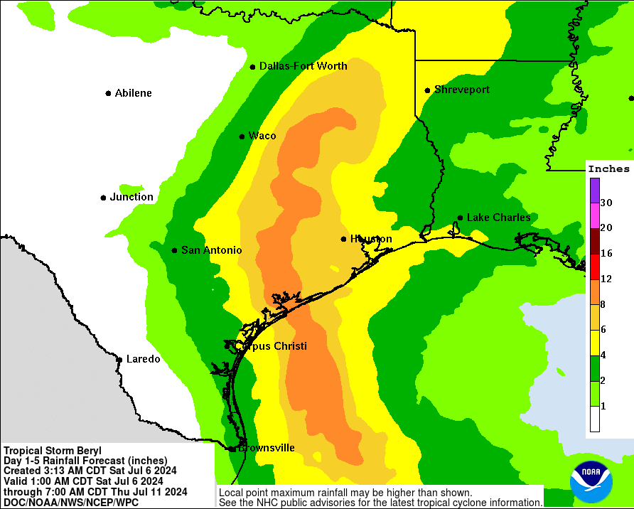
and intensity of Beryl. Based on the latest National Hurricane Center
forecast from early this morning, expect increasing shower/thunderstorm
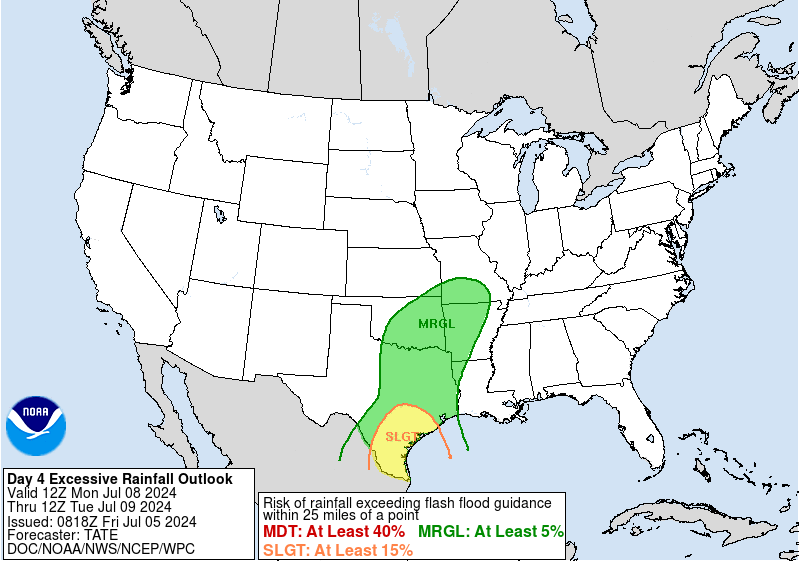
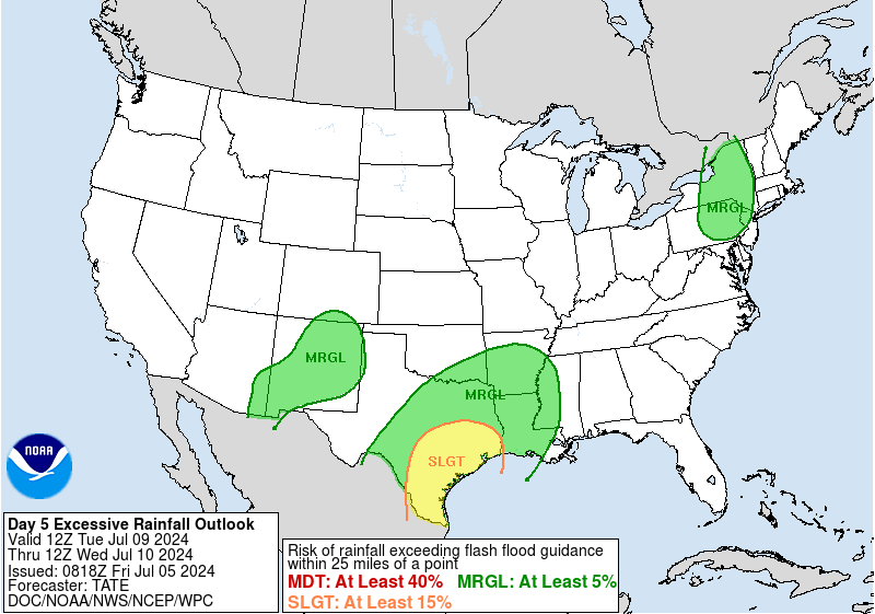
coverage for our area (locally heavy rainfall the primary severe weather
threat) as Beryl makes landfall near/around the South Texas coast Sunday
night or early Monday morning and works its way generally northwestward
then northward inland through Tuesday night and Wednesday. Locations
experiencing the strongest winds/rains look to be closer to Beryl`s
track which at this time would be our western areas, roughly from in/around
the Matagorda Bay area northward to in/around the Bryan/College Station
area. Shower and thunderstorm chances will continue Tuesday through
Thursday for much of the area. The Weather Prediction Center has parts
of our area in their Excessive Rainfall Outlooks beginning on Sunday
(Marginal Risk in/around the Matagorda Bay area) with increasing coverage
and risk on Monday and Tuesday (Slight Risk increasing across almost
all of the area by Tuesday). The Storm Prediction Center has areas in/around
Matagorda Bay in a Marginal Risk for severe weather in their Day 3 Outlook
(7 AM Sunday through 7 AM Monday).
A lot can change with our forecast depending on where Beryl decides
to go, how strong she gets and how fast she moves, so stay tuned for
future updates.
42
&&
.AVIATION...
(12Z TAF Issuance)
Issued at 512 AM CDT Fri Jul 5 2024
VFR conditions prevail at the majority of the area terminals with
the lone exception being LBX as of right now. Winds will remain on
the light side generally less than 10 knots. Some isolated
showers may develop in the afternoon near the I-10 corridor, and
additional convective development is expected north of I-10 and
east of I-45 this afternoon. The northern convection may last into
the late evening hours.
&&
.MARINE...
Issued at 400 AM CDT Fri Jul 5 2024
A light to occasionally moderate onshore flow will prevail through
the next few days. Winds and seas will be on the rise later this weekend
into the first half of the upcoming week as first Beryl moves into
the Gulf of Mexico and towards the South Texas coast and then another
round of deep tropical moisture surges into the western Gulf. Elevated
water levels along the bays, high surf and strong rip currents are possible.
Multiple rounds of showers/storms that could result in higher winds/seas
can be expected.
Continue to monitor the progress of both Beryl and the second slug of
Gulf moisture as any additional changes in the track/intensity of
these systems are possible during the next few days.
42
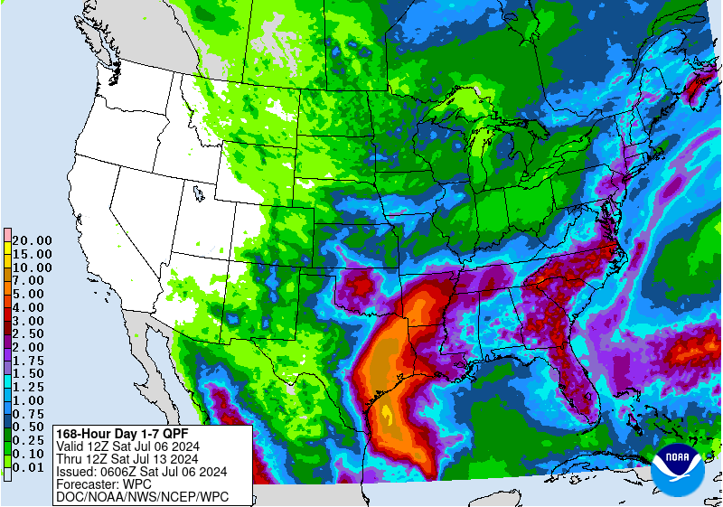
.CLIMATE...
Issued at 400 AM CDT Fri Jul 5 2024
The first four days of July have been very warm.
The average temperature for the Houston area was 89.0 degrees, which
was 5.0 degrees above normal. This is their second warmest start to
the month (1st place is 89.3 degrees in 1980). Records date back to
1889.
The average temperature for Houston Hobby was 88.9 degrees, which was
4.9 degrees above normal. This is their warmest start to the month
(second place is 88.1 degrees in 2023. Records date back to 1931.
The average temperature for Galveston was 87.8 degrees, which was 2.8
degrees above normal. This is their second warmest start to the month
(1st place is 88.1 degrees in 2005). Records date back to 1874.
The average temperature for Palacios was 86.5 degrees, which was 1.5
degrees above normal. This is their sixth warmest start to the month
(1st place is 89.1 degrees in 2023). Records date back to 1943.
The average temperature for College Station was 87.6 degrees, which
was 3.6 degrees above normal. This is their eighth warmest start
to the month (1st place is 89.5 degrees in 2009). Records date
back to 1889.
42
&&
.PRELIMINARY POINT TEMPS/POPS...
College Station (CLL) 98 77 95 77 / 10 20 40 10
Houston (IAH) 99 79 96 79 / 20 20 60 20
Galveston (GLS) 93 81 92 83 / 20 20 40 20
&&
.HGX WATCHES/WARNINGS/ADVISORIES...
TX...Heat Advisory until 7 PM CDT this evening for TXZ163-164-176>179-
195>200-210>214-226-227-235>238-300-313-335>338-436>439.
GM...None.
&&
$$
SHORT TERM...Batiste
LONG TERM....42
AVIATION...Batiste
MARINE...42
FXUS64 KHGX 051012
AFDHGX
Area Forecast Discussion
National Weather Service Houston/Galveston TX
512 AM CDT Fri Jul 5 2024
...New AVIATION...
.SHORT TERM...
(Today through Saturday Night)
Issued at 400 AM CDT Fri Jul 5 2024
We`ll have one more solid day with mid/upper level high pressure
directly overhead leading to temperatures this afternoon peaking in
the upper 90s to right around 100F for most of Southeast Texas
(except along the coast). Elevated humidity will keep heat index
values mainly in the 107-111F range, so a Heat Advisory remains in
effect for all of Southeast Texas through 7pm CDT this evening. For
those keeping count, this is the 11th day in a row with a Heat
Advisory for at least part of Southeast Texas...and we might make
that 12 days in a row tomorrow. Before we get to that though, let`s
talk about a cold front that will approach from the north later
today. As an upper level trough swings through the Upper Midwest,
it`ll serve to break down the ridge aloft and nudge it eastward.
This reduces the amount of subsidence aloft, but that portion of it
will play more of a factor on Saturday. The parent surface low for
this frontal boundary will be in the Great Lakes region, so we`ll be
on the very tail-end of it. The front itself may partially push into
portions of the Brazos Valley late Friday night/Saturday morning and
carry some scattered showers/storms along with it.
Rain chances will be highest east of I-45 in association with this
weak frontal boundary, and this is probably a good time to mention
that we`ll also have our typical afternoon isolated to scattered
seabreeze convection on top of that. As previously mentioned, with
the reduction in subsidence aloft by Saturday, we`ll likely see
increased coverage of rainfall. To give y`all an idea of what that
looks like...PoPs on Friday are ~20% and on Saturday they`re bumped
up to 40-60%. A weaker ridge and higher rain chances means a slight
decrease in high temperatures. Saturday`s highs will top out in the
mid to upper 90s with the hotter temperatures west of I-45. Moisture
convergence due to the front being nearby will lead to PW values
surging to near 2.3-2.4" Saturday afternoon, so plenty of moisture
to work with! With PW values well above the 90th percentile
(~2.10"), there will be potential for locally heavy rainfall. As a
result, WPC has outlined most of Southeast Texas in a marginal risk
(level 1 of 4) for excessive rainfall. That also means plenty of
humidity as well as we`ll face yet another day with heat index
values in the 106-111F range, so there is potential for another
Heat Advisory.
Later in the day on Saturday, another upper level trough swings into
the Northern Plains and that creates an area of weakness over the
state of Texas between the approaching trough and the departing
ridge. This may play a factor in the track of Beryl and is one of
the numerous reasons that uncertainty remains in the forecast for
where it makes landfall. For additional details on Beryl, see the
"Tropical" discussion down below.
Batiste
&&
.LONG TERM...
(Sunday through Thursday)
Issued at 400 AM CDT Fri Jul 5 2024
This part of the forecast is heavily influenced by the future track
and intensity of Beryl. Based on the latest National Hurricane Center
forecast from early this morning, expect increasing shower/thunderstorm
coverage for our area (locally heavy rainfall the primary severe weather
threat) as Beryl makes landfall near/around the South Texas coast Sunday
night or early Monday morning and works its way generally northwestward
then northward inland through Tuesday night and Wednesday. Locations
experiencing the strongest winds/rains look to be closer to Beryl`s
track which at this time would be our western areas, roughly from in/around
the Matagorda Bay area northward to in/around the Bryan/College Station
area. Shower and thunderstorm chances will continue Tuesday through
Thursday for much of the area. The Weather Prediction Center has parts
of our area in their Excessive Rainfall Outlooks beginning on Sunday
(Marginal Risk in/around the Matagorda Bay area) with increasing coverage
and risk on Monday and Tuesday (Slight Risk increasing across almost
all of the area by Tuesday). The Storm Prediction Center has areas in/around
Matagorda Bay in a Marginal Risk for severe weather in their Day 3 Outlook
(7 AM Sunday through 7 AM Monday).
A lot can change with our forecast depending on where Beryl decides
to go, how strong she gets and how fast she moves, so stay tuned for
future updates.
42
&&
.AVIATION...
(12Z TAF Issuance)
Issued at 512 AM CDT Fri Jul 5 2024
VFR conditions prevail at the majority of the area terminals with
the lone exception being LBX as of right now. Winds will remain on
the light side generally less than 10 knots. Some isolated
showers may develop in the afternoon near the I-10 corridor, and
additional convective development is expected north of I-10 and
east of I-45 this afternoon. The northern convection may last into
the late evening hours.
&&
.MARINE...
Issued at 400 AM CDT Fri Jul 5 2024
A light to occasionally moderate onshore flow will prevail through
the next few days. Winds and seas will be on the rise later this weekend
into the first half of the upcoming week as first Beryl moves into
the Gulf of Mexico and towards the South Texas coast and then another
round of deep tropical moisture surges into the western Gulf. Elevated
water levels along the bays, high surf and strong rip currents are possible.
Multiple rounds of showers/storms that could result in higher winds/seas
can be expected.
Continue to monitor the progress of both Beryl and the second slug of
Gulf moisture as any additional changes in the track/intensity of
these systems are possible during the next few days.
42
.CLIMATE...
Issued at 400 AM CDT Fri Jul 5 2024
The first four days of July have been very warm.
The average temperature for the Houston area was 89.0 degrees, which
was 5.0 degrees above normal. This is their second warmest start to
the month (1st place is 89.3 degrees in 1980). Records date back to
1889.
The average temperature for Houston Hobby was 88.9 degrees, which was
4.9 degrees above normal. This is their warmest start to the month
(second place is 88.1 degrees in 2023. Records date back to 1931.
The average temperature for Galveston was 87.8 degrees, which was 2.8
degrees above normal. This is their second warmest start to the month
(1st place is 88.1 degrees in 2005). Records date back to 1874.
The average temperature for Palacios was 86.5 degrees, which was 1.5
degrees above normal. This is their sixth warmest start to the month
(1st place is 89.1 degrees in 2023). Records date back to 1943.
The average temperature for College Station was 87.6 degrees, which
was 3.6 degrees above normal. This is their eighth warmest start
to the month (1st place is 89.5 degrees in 2009). Records date
back to 1889.
42
&&
.PRELIMINARY POINT TEMPS/POPS...
College Station (CLL) 98 77 95 77 / 10 20 40 10
Houston (IAH) 99 79 96 79 / 20 20 60 20
Galveston (GLS) 93 81 92 83 / 20 20 40 20
&&
.HGX WATCHES/WARNINGS/ADVISORIES...
TX...Heat Advisory until 7 PM CDT this evening for TXZ163-164-176>179-
195>200-210>214-226-227-235>238-300-313-335>338-436>439.
GM...None.
&&
$$
SHORT TERM...Batiste
LONG TERM....42
AVIATION...Batiste
MARINE...42


There is no way Beryl is going to be another Harvey. Harvey lingered for a few days. Beryl is coming and going like Ike.
-
- Information
-
Who is online
Users browsing this forum: Bing [Bot], Google [Bot], TexasBreeze and 4 guests