
December Weather Discussion. Will We See Rain?


I saw the 16 day forecast and notice that it may rain on December 20-21, the night of the total lunar eclipse. Last one until April 2014. 


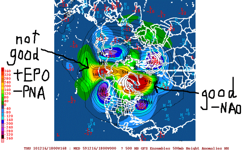
The only thing that is doing is keeping us from torching. It's also helping us to stay quite dry... This -PNA, -NAO pattern is keeping a dry northwesterly flow over Texas.Andrew wrote:
And a -NAO
We need the PNA and EPO pattern to reverse to see any kind of "fun". It is true, however, that the upcoming blocking episodes across the Arctic will be quite intense, similarly as this past December and early January. The difference this year is the Pacific (another reason why the Pacific is way more important for us than the Atlantic). It doesn't matter how low that index goes as long as the Pacific stays where it is.
That is an insane block across Greenland by day 7...
But see that ridging across the Aluetians? That is bad. It is helping to sustain the trough pattern over the Gulf of Alaska which is in turn allowing all cold outbreaks to go east while we stay cool and dry. Again, the only thing keeping us from torching like crazy is the intense -NAO. If we can get some of the ridging across the Aluetians to head off to the east and hook up with some of the block across Northern Canada, it's a whole nother ballgame...
Last edited by Mr. T on Thu Dec 09, 2010 9:31 pm, edited 1 time in total.
-
Andrew
- Site Admin

- Posts: 3440
- Joined: Wed Feb 03, 2010 9:46 pm
- Location: North-West Houston
- Contact:
Mr. T wrote:The only thing that is doing is keeping us from torching. It's also helping us to stay quite dry... This -PNA, -NAO pattern is keeping a dry northwesterly flow over Texas.Andrew wrote:
And a -NAO
We need the PNA and EPO pattern to reverse to see any kind of "fun". It is true, however, that the upcoming blocking episodes across the Arctic will be quite intense, similarly as this past December and early January. The difference this year is the Pacific (another reason why the Pacific is way more important for us than the Atlantic). It doesn't matter how low that index goes as long as the Pacific stays where it is.
Yea I was mainly showing that for the east coast. They could get really cold next week. As you can see though the -NAO pattern is supposed to lesson at the end of the run which the gfs is showing some nice cold air coming south.
For Your Infinite Source For All Things Weather Visit Our Facebook

Models are probably starting to respond to this:

Some of those ensemble members even have the AO going lower than last year's record reach (literally off the charts)... Of course, after the AO tanked around New Year's last year is when we had our arctic outbreak in early January.
If the Pacific could cooperate just for a little bit, it's going to get darn cold and stormy across the Southern Plains.
-
biggerbyte
- Posts: 1142
- Joined: Thu Feb 04, 2010 12:15 am
- Location: Porter, Texas. (Montgomery County)
- Contact:
Yes, it is being watched. Sure would be nice if that pattern change would actually happen. In the meantime, folks east of here are in for some serious winter weather. I'm speaking of the state of Tennessee, for instance. It sure would be nice if Texas could get in on some real action this season. I'm so ready for it, as I know you guys are as well. Well, maybe excepting wxman.. 
-
TexasBreeze
- Posts: 943
- Joined: Sun Sep 26, 2010 4:46 pm
- Location: NW Houston, TX
- Contact:
Except me too. It's useless to have real cold sniffley runny nose weather without snow or ice. I like when it's 60's or 70's best.
That ridge/trough configuration over us and to the west is giving us NW flow sending coldest air east and saving us from ice concerns. Since the weather is so dry lately, that pattern configuration is fine with me!
That ridge/trough configuration over us and to the west is giving us NW flow sending coldest air east and saving us from ice concerns. Since the weather is so dry lately, that pattern configuration is fine with me!
-
wxman57

- Global Moderator

- Posts: 2621
- Joined: Thu Feb 04, 2010 5:34 am
- Location: Southwest Houston (Westbury)
- Contact:
You're right on that one, but my boss is complaining about the lack of any significant weather across south. Hard to sell weather services when there are no weather threats. No severe weather in the spring, no hurricanes, no severe storms in the fall, no ice. Can anyone remember our last good line of thunderstorms? I can't remember the last time I heard thunder.biggerbyte wrote:Yes, it is being watched. Sure would be nice if that pattern change would actually happen. In the meantime, folks east of here are in for some serious winter weather. I'm speaking of the state of Tennessee, for instance. It sure would be nice if Texas could get in on some real action this season. I'm so ready for it, as I know you guys are as well. Well, maybe excepting wxman..
Tell you what, I'll agree with you that this weather is just too boring. Let's all wish for a nice Christmas/New Year's heat wave with temps in the 90s! Wouldn't that be exciting!

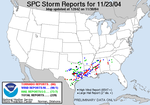
Lol I totally agree, but honestly Houston hasn't seen a REAL severe weather outbreak (at least one that verified) since November of 2004, when a strong scroll line moved through causing numerous reports of wind damage and some reports of tornado's across Southeast Texas.To me that was the last moderate risk that actually verified.
-
wxman57
- Global Moderator
- Posts: 2621
- Joined: Thu Feb 04, 2010 5:34 am
- Location: Southwest Houston (Westbury)
- Contact:
Remember that outbreak well. I was actually out on my road bike out of Stephen F. Austin state park and Sealy that day. Storms were chasing us back to the car at the park. We were about 2-3 miles from reaching the car when a big dark cloud approached. We took cover in a barn. Heard what sounded like a tornado going by. There wasn't any internet back then, and no such thing as a smart phone to check radar while out on the bikes. We really didn't know what was going on. On the drive back to Houston from the park, we saw spotty damage and power was out along I-10.
Generally, I'd advise against doing any tornado chasing on a bicycle.
Generally, I'd advise against doing any tornado chasing on a bicycle.


From what I remember the squall line is what cleared everything out after about 3 days of severe weather and flooding rains across the region. Wharton county saw 12-16'' of rain on the 21st followed by more locally heavy rain and tornadoes on the 22nd before the big event on the 23rd.
It has been interesting the past several years, especially during spring when most severe events get squashed by a stubborn capping inversion due to 850-700mb winds blowing more from the southwest then the south. That brings in warm stable air from Mexico just above the surface which pretty much stops thunderstorm development, unless we get close enough to the main upper level dynamics and can cool down enough aloft to erode the cap away. Unfortunately, the main dynamics have tended to remain too far north of us to really help. Looking at the November 23rd, 2004 case from the SPC site, you can see that the strong mid level low and associated energy was digging all the way down into northern Mexico before taking on a negative tilt as it ejects across west Texas. Recently we have seen less systems dig that far south so we have been at the mercy of the cap which more often than not, wins out.
It has been interesting the past several years, especially during spring when most severe events get squashed by a stubborn capping inversion due to 850-700mb winds blowing more from the southwest then the south. That brings in warm stable air from Mexico just above the surface which pretty much stops thunderstorm development, unless we get close enough to the main upper level dynamics and can cool down enough aloft to erode the cap away. Unfortunately, the main dynamics have tended to remain too far north of us to really help. Looking at the November 23rd, 2004 case from the SPC site, you can see that the strong mid level low and associated energy was digging all the way down into northern Mexico before taking on a negative tilt as it ejects across west Texas. Recently we have seen less systems dig that far south so we have been at the mercy of the cap which more often than not, wins out.
-
biggerbyte
- Posts: 1142
- Joined: Thu Feb 04, 2010 12:15 am
- Location: Porter, Texas. (Montgomery County)
- Contact:
Setting personal preference aside, there is one aspect about weather that some might easily forget. Weather changes that each season brings is there for a reason. Each change brings balance and renewal. Without that balance and renewal, every living thing would be doomed. Even thunderstorms and hurricanes have a purpose other than destruction. So the next time anyone wishes for one weather pattern to suit their personal fancy....
Food for thought...
Food for thought...
I moved to Houston in 2006 (Kingwood) from California. I've always been facinated by weather, the awesome thundestorms (as well as the housing market) were key incentives to moving here.
I remember looking at the wunderground radar several times in 2006 where there was so much lightning you couldn't even see the city on the map, just solid white squares. I thought I hit the jackpot for thunderstorm watching...until 2007, then 2008, 2009 and now 2010. It seems like thunderstorms have just dried up completely.
I know weather patterns are cyclical, I wonder if there is any historical data that would show a trend as far as how long these dry spells may last.
Last edited by CAK on Fri Dec 10, 2010 1:04 pm, edited 1 time in total.
Try these linksCAK wrote:I moved to Houston in 2006 (Kingwood) from California. I've always been facinated by weather, the awesome thundestorms (as well as the housing market) were key incentives to moving here.
I remember looking at the wunderground radar several times in 2006 where there was so much lightning you couldn't even see the city on the map, just solid white squares. I thought I hit the jackpot for thunderstorm watching...until 2007, then 2008, 2009 and now 2010. It seems like thunderstorms have just dried up completely.
I know weather patterns are cyclical, I wonder if there is any historical data that would show a trend as far as how long these dry spells may last.
Divisional Weather
http://www7.ncdc.noaa.gov/CDO/CDODivisionalSelect.jsp
It has monthly rainfall total for region, moisture, and
NCDC Storm Events
http://www4.ncdc.noaa.gov/cgi-win/wwcgi ... ent~Storms
Severe weather events going back to 1950.
-
redneckweather
- Posts: 1023
- Joined: Mon Feb 08, 2010 7:29 pm
- Location: Montgomery, Texas
- Contact:
I'm a huge weaher weenie.I actually depend on exciting weather to get me through a work week. You can imagine the depression I am going through gong all the way back to......oh man, I don't even remember when we had anything exiciting around here. I'm a beer drinker but I might switch to something heavier till this trend ends....maybe crown?
Have you see the vid on youtube of those two storm chasers hold up under that overpass during Hurricane Charley? I could use some of that right about now!
Have you see the vid on youtube of those two storm chasers hold up under that overpass during Hurricane Charley? I could use some of that right about now!
-
srainhoutx

- Site Admin
- Posts: 19616
- Joined: Tue Feb 02, 2010 2:32 pm
- Location: Maggie Valley, NC
- Contact:
The front is making progress S at a fairly good clip. While we are in the 70's at this hour, the front is through a Del Rio, Georgetown, Waco line heading S...

Carla/Alicia/Jerry(In The Eye)/Michelle/Charley/Ivan/Dennis/Katrina/Rita/Wilma/Humberto/Ike/Harvey
Member: National Weather Association
Facebook.com/Weather Infinity
Twitter @WeatherInfinity
Member: National Weather Association
Facebook.com/Weather Infinity
Twitter @WeatherInfinity
-
wxman57
- Global Moderator
- Posts: 2621
- Joined: Thu Feb 04, 2010 5:34 am
- Location: Southwest Houston (Westbury)
- Contact:
12Z GFS indicates a fairly strong cold front arriving on the afternoon of the 23rd and temps near freezing for Christmas. Maybe a few showers ahead of the front. That's about it for "excitement" the next 2 weeks. Heading out on the bikes now to enjoy this nice December weather. 30 miles this afternoon and 20 miles this evening for the Christmas lights ride with the Houston Bicycle Club. That will be interesting, as we'll be hit by the front near the start of the ride. Temperature will fall 15-20 degrees the first hour. I'm bringing my Arctic survival cycling gear. 
-
srainhoutx
- Site Admin
- Posts: 19616
- Joined: Tue Feb 02, 2010 2:32 pm
- Location: Maggie Valley, NC
- Contact:
Front just passed NW Harris County and skies have cleared. Dewpoint are dropping quickly and a Red Flag Warning is in affect for SE TX tomorrow.
URGENT - FIRE WEATHER MESSAGE
NATIONAL WEATHER SERVICE HOUSTON/GALVESTON TX
305 PM CST SAT DEC 11 2010
...STRONG NORTHWEST WINDS AND LOW HUMIDITIES EXPECTED SUNDAY IN
THE WAKE OF A COLD FRONT...
.THE COMBINATION OF GUSTY NORTHWEST WINDS...LOW HUMIDITIES...AND
ONGOING DROUGHT WILL RESULT IN CRITICAL FIRE WEATHER CONDITIONS
SUNDAY.
TXZ163-164-176>179-195>200-210>214-226-227-235>238-121200-
/O.UPG.KHGX.FW.A.0004.101212T1500Z-101213T0000Z/
/O.NEW.KHGX.FW.W.0005.101212T1600Z-101213T0100Z/
AUSTIN-BRAZORIA-BRAZOS-BURLESON-CHAMBERS-COLORADO-FORT BEND-
GALVESTON-GRIMES-HARRIS-HOUSTON-JACKSON-LIBERTY-MADISON-MATAGORDA-
MONTGOMERY-POLK-SAN JACINTO-TRINITY-WALKER-WALLER-WASHINGTON-
WHARTON-
305 PM CST SAT DEC 11 2010
...RED FLAG WARNING IN EFFECT FROM 10 AM TO 7 PM CST SUNDAY...
THE NATIONAL WEATHER SERVICE IN HOUSTON/GALVESTON HAS ISSUED A
RED FLAG WARNING...WHICH IS IN EFFECT FROM 10 AM TO 7 PM CST
SUNDAY. THE FIRE WEATHER WATCH IS NO LONGER IN EFFECT.
NORTHWEST WINDS OF 15 TO 25 MPH WITH HIGHER GUSTS CAN BE EXPECTED
OVER THE AREA SUNDAY. THE GUSTY WINDS WILL PERSIST UNTIL SUNSET.
HUMIDITY LEVELS WILL DROP BELOW 30 PERCENT BETWEEN 10 AND 11
AM...AND BOTTOM OUT IN THE 10 TO 20 PERCENT RANGE SUNDAY
AFTERNOON. HUMIDITY LEVELS WILL RECOVER ABOVE 30 PERCENT SHORTLY
AFTER SUNSET. THE COMBINATION OF GUSTY WINDS AND LOW HUMIDITY
LEVELS WILL RESULT IN CRITICAL FIRE WEATHER CONDITIONS.
Carla/Alicia/Jerry(In The Eye)/Michelle/Charley/Ivan/Dennis/Katrina/Rita/Wilma/Humberto/Ike/Harvey
Member: National Weather Association
Facebook.com/Weather Infinity
Twitter @WeatherInfinity
Member: National Weather Association
Facebook.com/Weather Infinity
Twitter @WeatherInfinity
-
- Information
-
Who is online
Users browsing this forum: Ahrefs [Bot], Amazon [Bot], Stratton20 and 9 guests