
Extratropical Depression Lee: Inland N Gulf States
-
biggerbyte
- Posts: 1142
- Joined: Thu Feb 04, 2010 12:15 am
- Location: Porter, Texas. (Montgomery County)
- Contact:
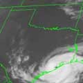
Okay! Back to reality. Folks, there is a very good chance that as the night progresses we will see the heavy rain shield extend westward into east and S.E. Texas.. Also, a Tropical Depression/Storm declaration very soon looks likely. Shear is letting up, and Satellite and Radar loops are telling. I'll give the newbies some links later on. Time to throw out the models and look at what is actually happening from hour to hour. Chin up, everyone. No more letting each model run drive us all insane?
-
srainhoutx

- Site Admin

- Posts: 19616
- Joined: Tue Feb 02, 2010 2:32 pm
- Location: Maggie Valley, NC
- Contact:
NOAA RECON is doing 'tight turns' near what looks to be a center of circulation. If we see a vortex message transmitted, we will likely see an upgrade.
Carla/Alicia/Jerry(In The Eye)/Michelle/Charley/Ivan/Dennis/Katrina/Rita/Wilma/Humberto/Ike/Harvey
Member: National Weather Association
Facebook.com/Weather Infinity
Twitter @WeatherInfinity
Member: National Weather Association
Facebook.com/Weather Infinity
Twitter @WeatherInfinity

Am I seeing this correctly? The center is near 92W and 27N ? moving W? The longer it takes to develop the more west it will go
-
srainhoutx
- Site Admin
- Posts: 19616
- Joined: Tue Feb 02, 2010 2:32 pm
- Location: Maggie Valley, NC
- Contact:
BEGIN
NHC_ATCF
invest_RENUMBER_al932011_al082011.ren
FSTDA
R
U
040
010
0000
201108190146
NONE
NOTIFY=ATRP
END
NHC_ATCF
invest_RENUMBER_al932011_al082011.ren
FSTDA
R
U
040
010
0000
201108190146
NONE
NOTIFY=ATRP
END
Carla/Alicia/Jerry(In The Eye)/Michelle/Charley/Ivan/Dennis/Katrina/Rita/Wilma/Humberto/Ike/Harvey
Member: National Weather Association
Facebook.com/Weather Infinity
Twitter @WeatherInfinity
Member: National Weather Association
Facebook.com/Weather Infinity
Twitter @WeatherInfinity
srainhoutx wrote:BEGIN
NHC_ATCF
invest_RENUMBER_al932011_al082011.ren
FSTDA
R
U
040
010
0000
201108190146
NONE
NOTIFY=ATRP
END
What does this mean Srainhoutx?
-
Andrew
- Site Admin
- Posts: 3440
- Joined: Wed Feb 03, 2010 9:46 pm
- Location: North-West Houston
- Contact:
An upgrade to either a TD or TS.ticka1 wrote:srainhoutx wrote:BEGIN
NHC_ATCF
invest_RENUMBER_al932011_al082011.ren
FSTDA
R
U
040
010
0000
201108190146
NONE
NOTIFY=ATRP
END
What does this mean Srainhoutx?
For Your Infinite Source For All Things Weather Visit Our Facebook
-
srainhoutx
- Site Admin
- Posts: 19616
- Joined: Tue Feb 02, 2010 2:32 pm
- Location: Maggie Valley, NC
- Contact:
Product: NOAA Vortex Message (URNT12 KWBC)
Transmitted: 1st day of the month at 22:30Z
Aircraft: Lockheed WP-3D Orion (Reg. Num. N42RF)
Mission Purpose: Investigate seventh suspect area (flight in the North Atlantic basin)
Mission Number: 1
Observation Number: 12
A. Time of Center Fix: 1st day of the month at 22:01Z
B. Center Fix Coordinates: 26°25'N 91°33'W (26.4167N 91.55W)
B. Center Fix Location: 262 miles (422 km) to the SSW (200°) from New Orleans, LA, USA.
C. Minimum Height at Standard Level: Not Available
D & E. Estimated (by SFMR or visually) Maximum Surface Wind: Not Available
F. Maximum Flight Level Wind Inbound: From 324° at 7kts (From the NW at ~ 8.1mph)
G. Location of Maximum Flight Level Wind Inbound: 7 nautical miles (8 statute miles) to the WSW (246°) of center fix
H. Minimum Sea Level Pressure: 1008mb (29.77 inHg) - Extrapolated
I. Maximum Flight Level Temp & Pressure Altitude Outside Eye: 26°C (79°F) at a pressure alt. of 458m (1,503ft)
J. Maximum Flight Level Temp & Pressure Altitude Inside Eye: 26°C (79°F) at a pressure alt. of 460m (1,509ft)
K. Dewpoint Temp (collected at same location as temp inside eye): 25°C (77°F)
K. Sea Surface Temp (collected at same location as temp inside eye): 30°C (86°F)
L. Eye Character: Not Available
M. Eye Shape: Not Available
N. Fix Determined By: Penetration and Wind
N. Fix Level: Other - Not surface, 1500ft, 925mb (if vortex is newer than about mid 90's; see note for more), 850mb, 700mb, 500mb, 400mb, 300mb or 200mb
O. Navigation Fix Accuracy: 1 nautical mile
O. Meteorological Accuracy: 1 nautical mile
Remarks Section:
Maximum Flight Level Wind: 27kts (~ 31.1mph) in the northeast quadrant at 19:42Z
Sea Level Pressure Extrapolation From: 1,500 feet
Carla/Alicia/Jerry(In The Eye)/Michelle/Charley/Ivan/Dennis/Katrina/Rita/Wilma/Humberto/Ike/Harvey
Member: National Weather Association
Facebook.com/Weather Infinity
Twitter @WeatherInfinity
Member: National Weather Association
Facebook.com/Weather Infinity
Twitter @WeatherInfinity
Same here. A lot of "So where's this storm going?" from the co-workers. Thanks everybody for making me look smarter than I really am!mckinne63 wrote: my friends think I am now a weather person as I repeat most of what I have read here.
but the wrong one - it is TD13, not 08
Andrew wrote:An upgrade to either a TD or TS.ticka1 wrote:srainhoutx wrote:BEGIN
NHC_ATCF
invest_RENUMBER_al932011_al082011.ren
FSTDA
R
U
040
010
0000
201108190146
NONE
NOTIFY=ATRP
END
What does this mean Srainhoutx?
-
srainhoutx
- Site Admin
- Posts: 19616
- Joined: Tue Feb 02, 2010 2:32 pm
- Location: Maggie Valley, NC
- Contact:
You are correct. FTP file needed to be updated. Sorry for the confusion, but still the same outcome...unome wrote:but the wrong one - it is TD13, not 08
BEGIN
NHC_ATCF
invest_RENUMBER_al932011_al132011.ren
FSTDA
R
U
040
010
0000
201109012228
NONE
NOTIFY=ATRP
END
Carla/Alicia/Jerry(In The Eye)/Michelle/Charley/Ivan/Dennis/Katrina/Rita/Wilma/Humberto/Ike/Harvey
Member: National Weather Association
Facebook.com/Weather Infinity
Twitter @WeatherInfinity
Member: National Weather Association
Facebook.com/Weather Infinity
Twitter @WeatherInfinity
-
maroondreams
- Posts: 14
- Joined: Thu Feb 03, 2011 8:06 pm
- Location: Houston, Tx (77040)
- Contact:
ME TOO!!!mckinne63 wrote:Of course, my friends think I am now a weather person as I repeat most of what I have read here.
You know my fiance keeps asking if I want to be a metorologist now because I keep giving him updates. LOL. All I'm doing is repeating what I see on here. You guys keep making me look good. Oh and keep up the little nit picky debates on if it will or will not rain here. I laugh every time.
-
Andrew
- Site Admin
- Posts: 3440
- Joined: Wed Feb 03, 2010 9:46 pm
- Location: North-West Houston
- Contact:
I think we should start charging for entertainment here.maroondreams wrote:ME TOO!!!mckinne63 wrote:Of course, my friends think I am now a weather person as I repeat most of what I have read here.
You know my fiance keeps asking if I want to be a metorologist now because I keep giving him updates. LOL. All I'm doing is repeating what I see on here. You guys keep making me look good. Oh and keep up the little nit picky debates on if it will or will not rain here. I laugh every time.
For Your Infinite Source For All Things Weather Visit Our Facebook
-
Andrew
- Site Admin
- Posts: 3440
- Joined: Wed Feb 03, 2010 9:46 pm
- Location: North-West Houston
- Contact:
WHXX01 KWBC 012232
CHGHUR
TROPICAL CYCLONE GUIDANCE MESSAGE
NWS NATIONAL HURRICANE CENTER MIAMI FL
2232 UTC THU SEP 1 2011
DISCLAIMER...NUMERICAL MODELS ARE SUBJECT TO LARGE ERRORS.
PLEASE REFER TO NHC OFFICIAL FORECASTS FOR TROPICAL CYCLONE
AND SUBTROPICAL CYCLONE INFORMATION.
ATLANTIC OBJECTIVE AIDS FOR
DISTURBANCE THIRTEEN (AL132011) 20110901 1800 UTC
...00 HRS... ...12 HRS... ...24 HRS. .. ...36 HRS...
110901 1800 110902 0600 110902 1800 110903 0600
LAT LON LAT LON LAT LON LAT LON
BAMS 26.6N 91.4W 27.2N 93.2W 27.7N 94.5W 27.6N 95.6W
BAMD 26.6N 91.4W 26.9N 92.6W 27.1N 93.5W 27.2N 94.0W
BAMM 26.6N 91.4W 27.1N 92.8W 27.5N 93.9W 27.5N 94.5W
LBAR 26.6N 91.4W 27.0N 92.3W 27.5N 93.3W 28.0N 94.0W
SHIP 30KTS 33KTS 40KTS 46KTS
DSHP 30KTS 33KTS 40KTS 46KTS
...48 HRS... ...72 HRS... ...96 HRS. .. ..120 HRS...
110903 1800 110904 1800 110905 1800 110906 1800
LAT LON LAT LON LAT LON LAT LON
BAMS 27.2N 96.1W 26.0N 93.6W 28.9N 89.7W 31.6N 89.9W
BAMD 27.2N 94.3W 27.9N 93.0W 29.7N 91.9W 30.9N 92.4W
BAMM 27.4N 94.6W 28.2N 91.9W 30.8N 90.4W 32.4N 90.9W
LBAR 28.5N 95.0W 29.4N 96.3W 30.2N 97.0W 31.5N 97.2W
SHIP 56KTS 66KTS 68KTS 60KTS
DSHP 56KTS 44KTS 30KTS 27KTS
...INITIAL CONDITIONS...
LATCUR = 26.6N LONCUR = 91.4W DIRCUR = 310DEG SPDCUR = 2KT
LATM12 = 25.6N LONM12 = 88.7W DIRM12 = 306DEG SPDM12 = 14KT
LATM24 = 24.1N LONM24 = 87.0W
WNDCUR = 30KT RMAXWD = 75NM WNDM12 = 30KT
CENPRS = 1008MB OUTPRS = 1013MB OUTRAD = 180NM SDEPTH = M
RD34NE = 0NM RD34SE = 0NM RD34SW = 0NM RD34NW = 0NM
$$
NNNN
For Your Infinite Source For All Things Weather Visit Our Facebook
-
Andrew
- Site Admin
- Posts: 3440
- Joined: Wed Feb 03, 2010 9:46 pm
- Location: North-West Houston
- Contact:
I see we have a lot of guests currently. I would like to formally welcome the new members and all you guests feel free to register and say hello! We don't bite often.
For Your Infinite Source For All Things Weather Visit Our Facebook


-
Andrew
- Site Admin
- Posts: 3440
- Joined: Wed Feb 03, 2010 9:46 pm
- Location: North-West Houston
- Contact:
Code: Select all
422
WHXX01 KWBC 012232
CHGHUR
TROPICAL CYCLONE GUIDANCE MESSAGE
NWS NATIONAL HURRICANE CENTER MIAMI FL
2232 UTC THU SEP 1 2011

DISCLAIMER...NUMERICAL MODELS ARE SUBJECT TO LARGE ERRORS.
PLEASE REFER TO NHC OFFICIAL FORECASTS FOR TROPICAL CYCLONE
AND SUBTROPICAL CYCLONE INFORMATION.

ATLANTIC OBJECTIVE AIDS FOR

DISTURBANCE THIRTEEN (AL132011) 20110901 1800 UTC

...00 HRS... ...12 HRS... ...24 HRS. .. ...36 HRS...
110901 1800 110902 0600 110902 1800 110903 0600

LAT LON LAT LON LAT LON LAT LON
BAMS 26.6N 91.4W 27.2N 93.2W 27.7N 94.5W 27.6N 95.6W
BAMD 26.6N 91.4W 26.9N 92.6W 27.1N 93.5W 27.2N 94.0W
BAMM 26.6N 91.4W 27.1N 92.8W 27.5N 93.9W 27.5N 94.5W
LBAR 26.6N 91.4W 27.0N 92.3W 27.5N 93.3W 28.0N 94.0W
SHIP 30KTS 33KTS 40KTS 46KTS
DSHP 30KTS 33KTS 40KTS 46KTS

...48 HRS... ...72 HRS... ...96 HRS. .. ..120 HRS...
110903 1800 110904 1800 110905 1800 110906 1800

LAT LON LAT LON LAT LON LAT LON
BAMS 27.2N 96.1W 26.0N 93.6W 28.9N 89.7W 31.6N 89.9W
BAMD 27.2N 94.3W 27.9N 93.0W 29.7N 91.9W 30.9N 92.4W
BAMM 27.4N 94.6W 28.2N 91.9W 30.8N 90.4W 32.4N 90.9W
LBAR 28.5N 95.0W 29.4N 96.3W 30.2N 97.0W 31.5N 97.2W
SHIP 56KTS 66KTS 68KTS 60KTS
DSHP 56KTS 44KTS 30KTS 27KTS

...INITIAL CONDITIONS...
LATCUR = 26.6N LONCUR = 91.4W DIRCUR = 310DEG SPDCUR = 2KT
LATM12 = 25.6N LONM12 = 88.7W DIRM12 = 306DEG SPDM12 = 14KT
LATM24 = 24.1N LONM24 = 87.0W
WNDCUR = 30KT RMAXWD = 75NM WNDM12 = 30KT
CENPRS = 1008MB OUTPRS = 1013MB OUTRAD = 180NM SDEPTH = M
RD34NE = 0NM RD34SE = 0NM RD34SW = 0NM RD34NW = 0NM

$$
NNNN
For Your Infinite Source For All Things Weather Visit Our Facebook

Saw the models! All have shifted East (again) GGGRRRR...... 
I give up....we're losing our battle!
I give up....we're losing our battle!
Mike
Beaumont, TX
(IH-10 & College Street)
Beaumont, TX
(IH-10 & College Street)
-
desiredwxgd
- Posts: 125
- Joined: Wed Feb 03, 2010 6:30 pm
- Location: TX/LA/Southern New England
- Contact:
[quote="Andrew"][quote]WHXX01 KWBC 012232
CHGHUR
TROPICAL CYCLONE GUIDANCE MESSAGE
NWS NATIONAL HURRICANE CENTER MIAMI FL
2232 UTC THU SEP 1 2011
DISCLAIMER...NUMERICAL MODELS ARE SUBJECT TO LARGE ERRORS.
PLEASE REFER TO NHC OFFICIAL FORECASTS FOR TROPICAL CYCLONE
AND SUBTROPICAL CYCLONE INFORMATION.
All this tells me is that the models still don't have a good grip on what this feature is going to do...
JMS
SR. ENSC.
SR. ENSC.
-
Andrew
- Site Admin
- Posts: 3440
- Joined: Wed Feb 03, 2010 9:46 pm
- Location: North-West Houston
- Contact:
desiredwxgd wrote:Andrew wrote:WHXX01 KWBC 012232
CHGHUR
TROPICAL CYCLONE GUIDANCE MESSAGE
NWS NATIONAL HURRICANE CENTER MIAMI FL
2232 UTC THU SEP 1 2011
DISCLAIMER...NUMERICAL MODELS ARE SUBJECT TO LARGE ERRORS.
PLEASE REFER TO NHC OFFICIAL FORECASTS FOR TROPICAL CYCLONE
AND SUBTROPICAL CYCLONE INFORMATION.
All this tells me is that the models still don't have a good grip on what this feature is going to do...
Exactly! Also if you notice most models initialized this farther south. Also notice the current movement (as shown by the black line). I expect that movement to continue for at least through tonight. Current steering shows that.
For Your Infinite Source For All Things Weather Visit Our Facebook