
Extratropical Depression Lee: Inland N Gulf States
-
TexasBreeze
- Posts: 942
- Joined: Sun Sep 26, 2010 4:46 pm
- Location: NW Houston, TX
- Contact:
Wouldn't it be funny if the gfdl track took place. Lol

I guess I wasn't crazy after all this morning.
Heck, any model could be right at the moment.
Heck, any model could be right at the moment.
-
desiredwxgd
- Posts: 125
- Joined: Wed Feb 03, 2010 6:30 pm
- Location: TX/LA/Southern New England
- Contact:
Dr. Rick Knabb was just discussing the NAM. Who knows, maybe there is/will be something to it.
Edit to add- I meant Norcross
Edit to add- I meant Norcross
Last edited by desiredwxgd on Sat Sep 03, 2011 7:43 pm, edited 1 time in total.
JMS
SR. ENSC.
SR. ENSC.

There has definitely been a westward jog. Brian Norcross was just discussing that. They don't sound quite as confident as they did earlier. Interesting to note the models start disagreeing again this close to/after landfall. I'm liking the "WTF" model runs better. 
Ready for severe weather season!!
-
desiredwxgd
- Posts: 125
- Joined: Wed Feb 03, 2010 6:30 pm
- Location: TX/LA/Southern New England
- Contact:
We joke, but models all week have to a certain point brought the system back out off coast then back on shore.srainhoutx wrote:lol...18Z GFDL...
If the graphic displays again it is because I forgot how to remove when doing a quote.
JMS
SR. ENSC.
SR. ENSC.
srainhoutx wrote:lol...18Z GFDL...
Man i sure would like to see that verify.
-
srainhoutx

- Site Admin

- Posts: 19616
- Joined: Tue Feb 02, 2010 2:32 pm
- Location: Maggie Valley, NC
- Contact:
Lake Charles radar sure seems to suggest a westward motion...

Carla/Alicia/Jerry(In The Eye)/Michelle/Charley/Ivan/Dennis/Katrina/Rita/Wilma/Humberto/Ike/Harvey
Member: National Weather Association
Facebook.com/Weather Infinity
Twitter @WeatherInfinity
Member: National Weather Association
Facebook.com/Weather Infinity
Twitter @WeatherInfinity

Doesn't quite seem like the plausible idea for Lee but it is funny how it seems like some of these models are slowly starting to change their tune as to what becomes of Lee. Gonna be an interesting night of radar and model watching. Gotta go to work now .... will check in overnight to see what's new. Off to Seabrook for me.perk wrote:srainhoutx wrote:lol...18Z GFDL...
Man i sure would like to see that verify.
~~~When Thunder Roars Go Indoors~~~
~~~Turn Around Don't Drown~~~
~~~Run From The Water, Hide From The Wind~~~
~~~Turn Around Don't Drown~~~
~~~Run From The Water, Hide From The Wind~~~
Srain, seems to have been NW to W all day.
Looking at the radar, we should get in on some good rainssrainhoutx wrote:Lake Charles radar sure seems to suggest a westward motion...
-
desiredwxgd
- Posts: 125
- Joined: Wed Feb 03, 2010 6:30 pm
- Location: TX/LA/Southern New England
- Contact:
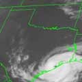
Looking as the visible (static and in motion), it really looks like an eye is trying to develop?????? Perhaps reforming a center south of previous??? Any thoughts???
Edit to add- Loop: http://www.ssd.noaa.gov/goes/flt/t1/loop-vis.html
Edit to add- Loop: http://www.ssd.noaa.gov/goes/flt/t1/loop-vis.html
- Attachments
-
- vis-l.jpg (22.84 KiB) Viewed 6920 times
JMS
SR. ENSC.
SR. ENSC.
desiredwxgd wrote:Looking as the visible (static and in motion), it really looks like an eye is trying to develop?????? Perhaps reforming a center south of previous??? Any thoughts???
Edit to add- Loop: http://www.ssd.noaa.gov/goes/flt/t1/loop-vis.html
I agree i was just about to post about that
On the radar im looking at, looks like a center forming just off shore south of lake charles?
-
txsnowmaker
- Posts: 632
- Joined: Wed Feb 03, 2010 4:07 pm
- Location: SW Houston (Galleria area)
- Contact:
What would it take for a Recon mission to be scheduled to investigate a possible new center trying to form south and west of the main system? (or would that not be necessary given the proximity to the coast/data already available?)
-
srainhoutx
- Site Admin
- Posts: 19616
- Joined: Tue Feb 02, 2010 2:32 pm
- Location: Maggie Valley, NC
- Contact:
IF a center was detected offshore via radar, I suspect re tasking in short order wouldn't be that big of a deal for the 53rd. After all, there were tasked missions that were cancelled and Keesler isn't that far away.txsnowmaker wrote:What would it take for a Recon mission to be scheduled to investigate a possible new center trying to form south and west of the main system? (or would that not be necessary given the proximity to the coast/data already available?)
Carla/Alicia/Jerry(In The Eye)/Michelle/Charley/Ivan/Dennis/Katrina/Rita/Wilma/Humberto/Ike/Harvey
Member: National Weather Association
Facebook.com/Weather Infinity
Twitter @WeatherInfinity
Member: National Weather Association
Facebook.com/Weather Infinity
Twitter @WeatherInfinity
-
txsnowmaker
- Posts: 632
- Joined: Wed Feb 03, 2010 4:07 pm
- Location: SW Houston (Galleria area)
- Contact:
Srain, thanks very much for your reply and for keeping everyone updated on the latest. In your opinion, based on the latest imagery, is the radar close to actually detecting a new center forming?srainhoutx wrote:IF a center was detected offshore via radar, I suspect re tasking in short order wouldn't be that big of a deal for the 53rd. After all, there were tasked missions that were cancelled and Keesler isn't that far away.txsnowmaker wrote:What would it take for a Recon mission to be scheduled to investigate a possible new center trying to form south and west of the main system? (or would that not be necessary given the proximity to the coast/data already available?)
Heavier rains passing my location
-
desiredwxgd
- Posts: 125
- Joined: Wed Feb 03, 2010 6:30 pm
- Location: TX/LA/Southern New England
- Contact:
Steve,
Perhaps it's just my eyes. Maybe a center has reformed south or the system has moved south. Your thoughts?
Perhaps it's just my eyes. Maybe a center has reformed south or the system has moved south. Your thoughts?
JMS
SR. ENSC.
SR. ENSC.


Lee's Latest Position
7:00 PM CDT Sat Sep 3
Location: 29.5°N 92.4°W
Max sustained: 50 mph
Moving: NNW at 4 mph
Min pressure: 988 mb
7:00 PM CDT Sat Sep 3
Location: 29.5°N 92.4°W
Max sustained: 50 mph
Moving: NNW at 4 mph
Min pressure: 988 mb
-
srainhoutx
- Site Admin
- Posts: 19616
- Joined: Tue Feb 02, 2010 2:32 pm
- Location: Maggie Valley, NC
- Contact:
Galveston is getting mighty close to TS conditions:
Code: Select all
Wind  from the NNW (330 degrees) at 35 MPH (30 KT) gusting to 44 MPH (38 KT)
Visibility  10 mile(s)
Sky conditions  overcast
Precipitation last hour  0.07 inches
Temperature  81.0 F (27.2 C)
Dew Point  69.1 F (20.6 C)
Relative Humidity  67%
Pressure (altimeter)  29.56 in. Hg (1001 hPa)
Carla/Alicia/Jerry(In The Eye)/Michelle/Charley/Ivan/Dennis/Katrina/Rita/Wilma/Humberto/Ike/Harvey
Member: National Weather Association
Facebook.com/Weather Infinity
Twitter @WeatherInfinity
Member: National Weather Association
Facebook.com/Weather Infinity
Twitter @WeatherInfinity