


I remember some snow on Easter of 2007 north of Houston.Candy Cane wrote:Hey, I've seen it snow in April in the Houston CWA. Anything is possible. Again, my answer to everything...
Edit- EWG Oklahoma Hell Snow!!!


-
srainhoutx

- Site Admin

- Posts: 19616
- Joined: Tue Feb 02, 2010 2:32 pm
- Location: Maggie Valley, NC
- Contact:
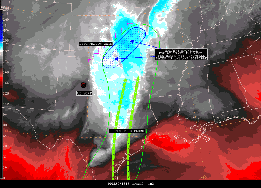
SATELLITE PRECIPITATION ESTIMATES..DATE/TIME 03/20/10 1328Z
SATELLITE ANALYSIS BRANCH/NESDIS---NPPU---TEL.301-763-8678
LATEST DATA USED: GOES-12: 1315Z BELGE
.
LOCATION...MISSOURI...OKLAHOMA...KANSAS...
.
ATTN WFOS...SGF...EAX...TSA...TOP...ICT...OUN...
ATTN RFCS...MBRFC...ABRFC...
.
EVENT...MOD/HVY SNOWFALL AFFECTING OK/KS.
.
SATELLITE ANALYSIS AND TRENDS...WV IMAGERY SHOWING UL VORT MOVING
INTO THE PANHANDLE OF TX AND SHOULD CLOSE OFF AS IT MOVES FURTHER EAST
TONIGHT. LOOKING AT THE LATEST 12UTC PW ANALYSIS..THE BEST LL MOISTURE
REMAINS FROM ERN TX NORTHWARD INTO ERN OK WITH SLIGHTLY LESSER BUT STILL
FAVORABLE MOISTURE INTO CNTRL AND SE KS. THIS MOISTURE PLUME ALONG WITH
A DEFORMATION AXIS ACROSS THIS REGION IS LINING UP NICELY WITH THE BAND
OF MOD TO HVY SNOWFALL SETTING UP FROM CNTRL/NRN OK INTO SE KS. IR STLT
SHOWS COOLING CLOUDS TOPS ASSOCIATED WITH THIS BAND AS WELL WHICH ALL IN
ALL COULD LEAD TO INCREASED SNOWFALL RATES OVER THE NEXT FEW HOURS WITH
THE POSSIBILITY OF 1-2" SNOW RATES PER HOURS. WILL CONTINUE TO MONITOR...
Carla/Alicia/Jerry(In The Eye)/Michelle/Charley/Ivan/Dennis/Katrina/Rita/Wilma/Humberto/Ike/Harvey
Member: National Weather Association
Facebook.com/Weather Infinity
Twitter @WeatherInfinity
Member: National Weather Association
Facebook.com/Weather Infinity
Twitter @WeatherInfinity
-
srainhoutx
- Site Admin
- Posts: 19616
- Joined: Tue Feb 02, 2010 2:32 pm
- Location: Maggie Valley, NC
- Contact:
AREA FORECAST DISCUSSION
NATIONAL WEATHER SERVICE FORT WORTH TX
1008 AM CDT SAT MAR 20 2010
.UPDATE...
DRY SLOT HAS ROTATED INTO NORTH TEXAS AND THE BRUNT OF THE
RAIN/STORMS HAS ENDED OR WILL END SHORTLY. INTENSE COLD ADVECTION
AT AND ABOVE THE SURFACE WILL CONTINUE THROUGH THE DAY...WITH MANY
LOCATIONS ALREADY REACHING THEIR HIGH TEMPS.
AS FAR AS SNOW POTENTIAL...WATER VAPOR CONTINUES TO SHOW THE UPPER
LEVEL SYSTEM DEEPENING AND DROPPING EAST-SOUTHEAST INTO THE TX
PANHANDLE. WRAP AROUND MOISTURE/ISENTROPIC LIFT WILL RESULT IN
LIGHT SNOW DEVELOPING AND MOVING INTO THE NW CWA DURING THE
AFTERNOON HOURS. SNOW IN CONJUNCTION WITH STRONG WINDS WILL RESULT
IN PERIODS OF REDUCED VISIBILITIES. THE STRONGEST LIFT AND WRAP
AROUND PRECIPITATION WILL OCCUR TO THE NORTHEAST OF A SHERMAN TO
CANTON LINE LATER TONIGHT AND SUNDAY...WHERE ACCUMULATIONS OF 2-3
INCHES ARE POSSIBLE. OTHERWISE...HAVE TONED DOWN THE SNOW AMOUNTS
IN THE NW AND METROPLEX AREA TO AN INCH OR LESS...WITH THE
PRIMARY IMPACT OF SNOWFALL EXPECTED TO BE FROM REDUCED
VISIBILITIES. WARM GROUNDS AND TEMPS ONLY NEAR OR BARELY BELOW
FREEZING WILL MITIGATE ACCUMULATION POTENTIAL ON ROADS IN THIS
AREA.
Carla/Alicia/Jerry(In The Eye)/Michelle/Charley/Ivan/Dennis/Katrina/Rita/Wilma/Humberto/Ike/Harvey
Member: National Weather Association
Facebook.com/Weather Infinity
Twitter @WeatherInfinity
Member: National Weather Association
Facebook.com/Weather Infinity
Twitter @WeatherInfinity
-
extremeweatherguy
- Posts: 5
- Joined: Mon Feb 08, 2010 10:22 am
- Location: just south of Oklahoma City, OK
- Contact:
Sorry it took me so long to post. I just realized that I had a thread addressing me on here.
Ironically, I am actually in Texas right now and am missing the storm back home. I plan on heading back tomorrow though, and will hopefully be able to report some on the aftermath once I return.
It does look like, so far, this has been a decent springtime storm. From what I have been hearing, the OKC metro area has picked up about 1-2 inches of windblown snow so far, and more appears to be on the way for later today. Based on the radar trends and models I am doubting that OKC sees the absolute worst of this storm, (which should be found further east/northeast), but up to 4-6 inches of snow with isolated higher totals definitely seems to be within the realm of possibility if things come together right. That should easily be enough to put the city near or above their all-time seasonal snowfall record.

I noticed that the NWS out of Dallas forecasting a half inch of snow in the metroplex, up to 3 inches in northeast Texas..
-
srainhoutx
- Site Admin
- Posts: 19616
- Joined: Tue Feb 02, 2010 2:32 pm
- Location: Maggie Valley, NC
- Contact:
DFW reporting light snow at this hour.
Carla/Alicia/Jerry(In The Eye)/Michelle/Charley/Ivan/Dennis/Katrina/Rita/Wilma/Humberto/Ike/Harvey
Member: National Weather Association
Facebook.com/Weather Infinity
Twitter @WeatherInfinity
Member: National Weather Association
Facebook.com/Weather Infinity
Twitter @WeatherInfinity