
Severe Weather 2024
-
tireman4

- Global Moderator

- Posts: 6899
- Joined: Wed Feb 03, 2010 9:24 pm
- Location: Humble, Texas
- Contact:
As the good Captain alluded to...
- Attachments
-
-
tireman4
- Global Moderator
- Posts: 6899
- Joined: Wed Feb 03, 2010 9:24 pm
- Location: Humble, Texas
- Contact:
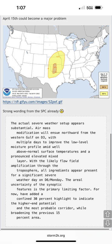
April 1 Potential Severe Weather
- Attachments
-
- Severe Weather 04 01 24.jpg (109.26 KiB) Viewed 84342 times
-
tireman4
- Global Moderator
- Posts: 6899
- Joined: Wed Feb 03, 2010 9:24 pm
- Location: Humble, Texas
- Contact:
Severe Weather
- Attachments
-
- Reed Timmer Severe Weather 04 01 24.jpg (86.67 KiB) Viewed 84342 times
-
tireman4
- Global Moderator
- Posts: 6899
- Joined: Wed Feb 03, 2010 9:24 pm
- Location: Humble, Texas
- Contact:
Snow.....in the Northeast....
- Attachments
-
- The Eyewall 04 02 24.jpg (118.27 KiB) Viewed 84318 times
-
Cpv17
- Posts: 6926
- Joined: Fri Aug 31, 2018 1:58 pm
- Location: El Campo/Wharton
- Contact:
-
Ptarmigan

- Statistical Specialist

- Posts: 4458
- Joined: Wed Feb 03, 2010 7:20 pm
- Contact:
-
Cpv17
- Posts: 6926
- Joined: Fri Aug 31, 2018 1:58 pm
- Location: El Campo/Wharton
- Contact:
-
tireman4
- Global Moderator
- Posts: 6899
- Joined: Wed Feb 03, 2010 9:24 pm
- Location: Humble, Texas
- Contact:
Severe Weather Update
- Attachments
-
- Severe Weather Update 04 23 24.jpg (98.58 KiB) Viewed 83695 times
-
tireman4
- Global Moderator
- Posts: 6899
- Joined: Wed Feb 03, 2010 9:24 pm
- Location: Humble, Texas
- Contact:
Reed Timmer, PhD
@ReedTimmerUSA
·
8m
Gassing up the Dominator 3 beneath some mid-level jellyfish clouds. Gearing up for a severe weather pattern we have not seen in many years across the southern Plains of Tornado Alley
@ReedTimmerUSA
·
8m
Gassing up the Dominator 3 beneath some mid-level jellyfish clouds. Gearing up for a severe weather pattern we have not seen in many years across the southern Plains of Tornado Alley
-
tireman4
- Global Moderator
- Posts: 6899
- Joined: Wed Feb 03, 2010 9:24 pm
- Location: Humble, Texas
- Contact:
Models of Severe Weather
- Attachments
-
- GL4t3TwWUAAkBda.png (105.45 KiB) Viewed 83684 times
-
tireman4
- Global Moderator
- Posts: 6899
- Joined: Wed Feb 03, 2010 9:24 pm
- Location: Humble, Texas
- Contact:
Severe Weather Forecast...
- Attachments
-
- Severe Weather Forecast 04 25 24.png (313.31 KiB) Viewed 83651 times
-
tireman4
- Global Moderator
- Posts: 6899
- Joined: Wed Feb 03, 2010 9:24 pm
- Location: Humble, Texas
- Contact:
Severe Weather 04 26 24
- Attachments
-
- Severe Weather 04 26 24.jpg (86.1 KiB) Viewed 83624 times
-
tireman4
- Global Moderator
- Posts: 6899
- Joined: Wed Feb 03, 2010 9:24 pm
- Location: Humble, Texas
- Contact:
Forecast for Tomorrow.
- Attachments
-
- Forecast for the Weekend 04 26 24.jpg
- (207.27 KiB) Downloaded 78131 times
-
DoctorMu

- Posts: 7748
- Joined: Sun Jun 28, 2015 11:58 am
- Location: College Station
- Contact:
Devastation near Omaha, especially Elkhorn. EF4 level stuff.
https://x.com/KNOPNews2/status/1784061675412332868
https://x.com/KNOPNews2/status/1784061675412332868
-
Cpv17
- Posts: 6926
- Joined: Fri Aug 31, 2018 1:58 pm
- Location: El Campo/Wharton
- Contact:
The Loveland, OK tornado has a chance to be an EF5 from what I’m hearing.
-
Cpv17
- Posts: 6926
- Joined: Fri Aug 31, 2018 1:58 pm
- Location: El Campo/Wharton
- Contact:
Beginning on Monday, much of next week is supposed to be a big multi-day severe weather outbreak. Most of it should remain north of us but on Wednesday it may start to creep into our area.
-
Cpv17
- Posts: 6926
- Joined: Fri Aug 31, 2018 1:58 pm
- Location: El Campo/Wharton
- Contact:
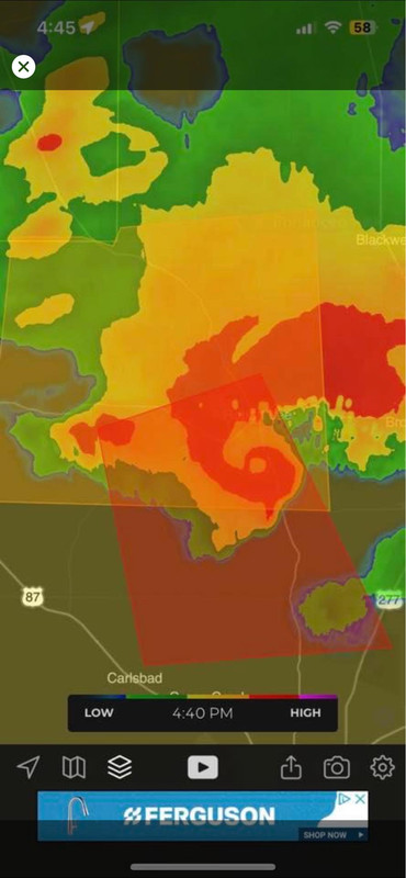
Massive hook with a pinhole eye on the radar just north of San Angelo, wow!
-
tireman4
- Global Moderator
- Posts: 6899
- Joined: Wed Feb 03, 2010 9:24 pm
- Location: Humble, Texas
- Contact:
Severe Weather 05 06 24
- Attachments
-
- Severe Weather 05 06 24.jpg (116.54 KiB) Viewed 71183 times
-
srainhoutx

- Site Admin

- Posts: 19700
- Joined: Tue Feb 02, 2010 2:32 pm
- Location: Maggie Valley, NC
- Contact:
- ww0189_radar.gif (57.34 KiB) Viewed 71066 times
Tornado Watch Number 189
NWS Storm Prediction Center Norman OK
200 PM CDT Mon May 6 2024
The NWS Storm Prediction Center has issued a
* Tornado Watch for portions of
Southern Kansas
Western and Central Oklahoma
Western North Texas
* Effective this Monday afternoon and evening from 200 PM until
1100 PM CDT.
...THIS IS A PARTICULARLY DANGEROUS SITUATION...
* Primary threats include...
Numerous tornadoes expected with a few intense tornadoes likely
Widespread large hail and scattered very large hail events to 4
inches in diameter likely
Scattered damaging winds and isolated significant gusts to 75
mph likely
SUMMARY...Explosive thunderstorm development is forecast this
afternoon along and east of a north to south oriented dryline.
Given a very favorable environment for severe thunderstorms, intense
supercells are expected to evolve. These storms are forecast to
move east across the Watch area this afternoon through the late
evening. The possibility exists for regenerative supercell
development over central Oklahoma this evening. Initially large to
giant hail is forecast with the initial supercell activity before
the tornado risk increases. Intense tornadoes are probable
especially as the atmosphere becomes very favorable for tornadoes
late this afternoon and continuing through the evening.
The tornado watch area is approximately along and 105 statute miles
east and west of a line from 25 miles north northwest of Hutchinson
KS to 50 miles south southeast of Fort Sill OK. For a complete
depiction of the watch see the associated watch outline update
(WOUS64 KWNS WOU9).
PRECAUTIONARY/PREPAREDNESS ACTIONS...
REMEMBER...A Tornado Watch means conditions are favorable for
tornadoes and severe thunderstorms in and close to the watch
area. Persons in these areas should be on the lookout for
threatening weather conditions and listen for later statements
and possible warnings.
&&
OTHER WATCH INFORMATION...CONTINUE...WW 187...WW 188...
AVIATION...Tornadoes and a few severe thunderstorms with hail
surface and aloft to 4 inches. Extreme turbulence and surface wind
gusts to 65 knots. A few cumulonimbi with maximum tops to 500. Mean
storm motion vector 24035.
...Smith
Carla/Alicia/Jerry(In The Eye)/Michelle/Charley/Ivan/Dennis/Katrina/Rita/Wilma/Humberto/Ike/Harvey
Member: National Weather Association
Facebook.com/Weather Infinity
Twitter @WeatherInfinity
Member: National Weather Association
Facebook.com/Weather Infinity
Twitter @WeatherInfinity