
May 2024
-
Stratton20
- Posts: 5612
- Joined: Tue Feb 09, 2021 11:35 pm
- Location: College Station, Texas
- Contact:
Good news after friday for those folks that have been hammered so hard by the rain the last few weeks, the mexican heat ridge begins to build in next week and looks to stay in place through the end of may, so we should have plenty of time to dry out, though i see alot of upper 90’s to near 100 in the future
-
tireman4

- Global Moderator

- Posts: 6750
- Joined: Wed Feb 03, 2010 9:24 pm
- Location: Humble, Texas
- Contact:
Matt Lanza
- Attachments
-
- Matt Lanza 05 16 24.jpg (123.08 KiB) Viewed 2823 times
-
tireman4
- Global Moderator
- Posts: 6750
- Joined: Wed Feb 03, 2010 9:24 pm
- Location: Humble, Texas
- Contact:
Matt Lanza 
@mattlanza
Conditions may become more favorable. I am somewhat intrigued by the haze that has descended over the city (likely agricultural smoke again) and if that impacts things at all. But regardless. Not a bad day to leave a few minutes early if you can.
2:03 PM · May 16, 2024
·

@mattlanza
Conditions may become more favorable. I am somewhat intrigued by the haze that has descended over the city (likely agricultural smoke again) and if that impacts things at all. But regardless. Not a bad day to leave a few minutes early if you can.
2:03 PM · May 16, 2024
·
-
jasons2k

- Posts: 6056
- Joined: Thu Feb 04, 2010 12:54 pm
- Location: Imperial Oaks
- Contact:
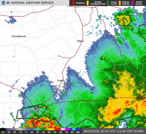
Hi-res satellite shows clouds building quickly right along the warm front arc…
-
jasons2k
- Posts: 6056
- Joined: Thu Feb 04, 2010 12:54 pm
- Location: Imperial Oaks
- Contact:
Also, just looking at satellite and radar, I do see a potentially very heavy rain/training event setup further south than the excessive rainfall maps. Houston metro needs to keep a watch. Same goes here for MoCo.
-
jasons2k
- Posts: 6056
- Joined: Thu Feb 04, 2010 12:54 pm
- Location: Imperial Oaks
- Contact:
Watch this band
- Attachments
-
- IMG_1390.png
- (2.85 MiB) Downloaded 2466 times
-
don

- Posts: 3106
- Joined: Wed Feb 03, 2010 3:33 pm
- Location: Wichita Falls
- Contact:
Yep the HRRR is showing such a scenario.
- Screenshot 2024-05-16 at 14-02-05 Models HRRR - Pivotal Weather.png (576.4 KiB) Viewed 2797 times
- Screenshot 2024-05-16 at 14-02-13 Models HRRR - Pivotal Weather.png (564.24 KiB) Viewed 2797 times
- Screenshot 2024-05-16 at 14-02-27 Models HRRR - Pivotal Weather.png (548.93 KiB) Viewed 2797 times
-
Cpv17
- Posts: 6818
- Joined: Fri Aug 31, 2018 1:58 pm
- Location: El Campo/Wharton
- Contact:
Tornado watch has just been issued till 10pm for all of the viewing area except for Jackson and Matagorda counties.
-
DoctorMu

- Posts: 7625
- Joined: Sun Jun 28, 2015 11:58 am
- Location: College Station
- Contact:
We're down to NowCasting. It's not monkeying around out there. We're about to get sandwiched.
No real complaints about rain now and a ridge is not necessarily good news unless we're north of it.
We simply need rain in the summer.
No real complaints about rain now and a ridge is not necessarily good news unless we're north of it.
We simply need rain in the summer.
-
tireman4
- Global Moderator
- Posts: 6750
- Joined: Wed Feb 03, 2010 9:24 pm
- Location: Humble, Texas
- Contact:
483
FXUS64 KHGX 161945
AFDHGX
Area Forecast Discussion
National Weather Service Houston/Galveston TX
245 PM CDT Thu May 16 2024
...New SHORT TERM, LONG TERM, MARINE, HYDROLOGY...
.SHORT TERM...
(This evening through Friday Night)
Issued at 242 PM CDT Thu May 16 2024
As of the time of writing (2PM CDT), a strengthening MCS is
approaching the area from the NW, with large-scale development aided
via the approach of a robust midlevel trough which continues to
swing westward into the Southern Plains. The continued approach of
this system, and its eventual impacts on SE TX throughout the
remainder of the afternoon and evening, presents both a severe
weather and a potentially significant flash flooding concern.
As indicated by recent SPC mesoanalysis, environmental conditions
ahead of the system`s approach remain favorable for both heavy rain
and severe storms. This includes:
- Abundant moisture availability, with total PWs of 1.8 to 2.2 in
across portions of the area and a steady low-level jet continuing to
supply the region with warm, moist Gulf air.
- Ample instability, with SB CAPE values in the region of 3000 -
4500 J/kg across portions of the area as well as limited convective
inhibition (CIN) and mid-level lapse rates of 7-8 degC/km.
- Effective layer bulk shear of approximately 50-60 knots, with
forecast soundings indicating a favorable backing directional shear
profile.
- A pocket of effective layer helicity of approximately 200 m^2/s^2
across portions of the Greater Houston area, supporting the isolated
tornado risk.
- Forecast Downdraft CAPE (DCAPE) values of approximately 700-1100
J/kg over the next several hours.
As such, we continue to keep a close eye on the radar over the next
4-6 hours. Stronger storms may produce large hail and strong wind
gusts, as well as the aforementioned isolated tornado threat.
Thunderstorm activity should become widespread over the next 1-2
hours as the complex pushes roughly from the NW to the SE, first
reaching the Brazos Valley and advancing towards the coast as we
head into the evening. Development will be further aided by the
presence of a stalled warm frontal boundary, which is expected to
sit just north of the I-10 corridor and extend to the east into the
Piney Woods region. Given this setup, along with the significant
ground saturation in place from recent rainfall, has resulted in the
WPC placing the region (roughly NE of metro Houston) in a High Risk
area for Excessive Rainfall. High resolution models indicate the
potential for 3-6" of new rainfall across the area through this
evening, with some locally higher amounts in excess of 6" possible
where the strongest storms set up. In addition to flash flooding,
this rainfall (and the subsequent runoff) will contribute and/or
exacerbate flooding along area rivers, streams, and creeks.
Further south and southwest, we continue to anticipate the potential
for 2-4" of new rainfall for metro Houston and lower (0.5-2")
amounts closer to the coast. Storms should generally push through
the Brazos Valley between around 3-5PM, metro Houston around 5-7PM
and the coast around 7-9PM. Some lingering showers may persist
further into the evening, particularly along the coast. The warm
frontal boundary will sag southward with the complex, likely
stalling out near the coast.
Tomorrow, the approach of a weak shortwave along with the presence
of a stalled boundary near the coast will result in another round of
scattered showers and storms. This will not present nearly as
significant as a severe weather/flooding threat as today, but will
nonetheless produce some additional measurable rainfall (especially
along and south of the I-10 corridor).
Cady
&&
.LONG TERM...
(Saturday through next Wednesday)
Issued at 242 PM CDT Thu May 16 2024
Quieter weather conditions are expected in the long term period. A
warming trend with near to above normal temperatures is expected as
ridging aloft builds over Mexico. The NAEFS/GEFS standardized
anomaly table maintains 1 to 2 standard deviations above normal for
500mb heights from next Monday through the end of the week. This
adds confidence that hot conditions will return into our area. With
sfc high pressure to our east, a southerly warm and humid airmass
will continue to filter in, resulting in hot and muggy conditions
through the week. Highs will generally range into the upper 80s to
mid 90s. Overnight lows mainly in the low 70s. A cool front will
attempt to move across the region by mid-week. Given the strong
influence of the ridge aloft; any precipitation will need to fight
the amount of dry layer at mid-levels. Have only included around 15
percent of PoP across our far northern counties for Wednesday and
Thursday.
JM
&&
.AVIATION...
(18Z TAF Issuance)
Issued at 1230 PM CDT Thu May 16 2024
A mix of MVFR to VFR conditions currently across SE TX sites. SE
winds of 10-15 KTS with gusts up to 25 KTS for today as a llvl jet
remains over our region. This afternoon, expect showers and
storms developing over portions of the CWA. A line of storms
developing along and near a boundary is currently making its way
into the Houston County border and is expected to continue further
south into the Brazos Valley and Piney Woods region this
afternoon and into the central portion (near I-10) sometime late
afternoon into the evening hours. Will need to keep a close eye on
this line given that some storms could be strong to severe and
will be capable of producing large hail, damaging winds, and
frequent lightning. Periods of heavy rainfall can also be expected
and would result in IFR vis at times. The stronger activity is
still expected to occur mainly for areas north of the I-10
corridor, but areas south of it could still have iso strong storms
at times. Another hazard to note is the possibility for llvl wind
shear to occur at times. SH/TS are expected to dissipate or move
away from our region by around midnight CT.
MVFR cigs and VRB winds expected tonight into early Fri morning
for most sites as the boundary moves closer towards the bays but
could stall as it does so. For now we are expecting for most sites
to be under N-NE winds thru Fri afternoon with GLS/LBX possibly
holding on to the SE wind direction for the rest of the TAF
period. This would ultimately depend on where the boundary stalls.
Cigs are expected to gradually lift later in the day, but will
also depend on where the location of the boundary.
Cotto (24)
&&
.MARINE...
Issued at 242 PM CDT Thu May 16 2024
A few showers and storms can be expected this afternoon and evening
ahead of a disturbance and a frontal boundary moving through SE TX.
The best precipitation chances will be on Friday along the
aforementioned boundary. Moderate onshore winds and seas around 3 to
5 ft are expected tonight. Small Craft Should Exercise Conditions
are in effect for all Gulf waters. Winds may reach advisory levels
at times. A brief window of offshore winds are expected by Friday as
the boundary moves through the waters. This boundary will possibly
stall over the coast through Saturday. Dry weather with light to
moderate onshore winds and low seas are expected for the remainder
of the period.
JM
&&
.HYDROLOGY...
Issued at 242 PM CDT Thu May 16 2024
Areas of showers and thunderstorms are expected to continue to
affect portions of Southeast TX through early tonight. Periods of
heavy rainfall is expected with this activity through this evening
with some rainfall rates of 2 to 3 inches per hour are possible.
Rainfall totals are estimated to be 3 to 6 inches with isolated
higher amounts for areas north of I-10 and 1 to 3 inches with
isolated higher amounts elsewhere.
Flash flooding can be expected as well as rises in rivers, small
streams, creeks and bayous. Runoff and rainfall over the rivers
upstream can result in further rises along the rivers over the next
few days.
Minor to major river flooding continues for parts of Southeast
Texas, particularly along portions of the Trinity and Brazos rivers.
The following river points are either currently in flood stage or
are forecast to reach flood stage (as of Thursday afternoon):
- Trinity River (Liberty): Major Flood Stage
- Trinity River (Goodrich): Minor Flood Stage rising to Major
- Trinity River (Riverside): Moderate Flood Stage
- Trinity River (Moss Bluff): Moderate Flood Stage
- Trinity River (Crockett): Minor Flood Stage
- East Fork San Jacinto (New Caney): Minor Flood Stage rising to
Moderate
- Navasota River (Normangee): Minor Flood Stage rising to Moderate
- Brazos River (Rosharon): Minor Flood Stage
- Menard Creek (Rye): Rising to Minor Flood Stage
- Brazos River (Sugar Land): Rising to Minor Flood Stage
Soils are already saturated from the previous rounds of rainfall in
the Piney Woods and this is where we expect the highest rainfall
totals once again, so we could see the rain become runoff fairly
quickly and caused additional responses along area rivers/creeks.
Please be sure to stay up to date on the latest forecast information.
Please monitor updated forecasts via the NWS AHPS website and/or
the new NWS NWPS webpage (https://water.noaa.gov/) as the river
flood threat continues.
Cotto
&&
.PRELIMINARY POINT TEMPS/POPS...
College Station (CLL) 67 82 67 89 / 70 20 10 10
Houston (IAH) 69 83 69 91 / 80 30 20 10
Galveston (GLS) 76 81 74 84 / 40 40 40 10
&&
.HGX WATCHES/WARNINGS/ADVISORIES...
TX...Flood Watch through Friday morning for TXZ163-164-176>179-
195>200-211>213-300-313.
GM...Small Craft Should Exercise Caution through Saturday morning for
GMZ350-355-370-375.
&&
$$
SHORT TERM...03
LONG TERM....JM
AVIATION...24
MARINE...JM
-
MH5
- Posts: 62
- Joined: Mon Jun 22, 2020 2:20 pm
- Location: Timbergrove
- Contact:
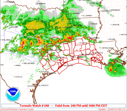
Tornado Watch issued.
-
tireman4
- Global Moderator
- Posts: 6750
- Joined: Wed Feb 03, 2010 9:24 pm
- Location: Humble, Texas
- Contact:
Yep, Tornado Watch...
- Attachments
-
- Tornado Watch 05 16 24.jpg (73.94 KiB) Viewed 2764 times
-
DoctorMu
- Posts: 7625
- Joined: Sun Jun 28, 2015 11:58 am
- Location: College Station
- Contact:
It's Total Eclipse level dark out there. Be ready folks.
It's rippin'
https://www.star.nesdis.noaa.gov/GOES/s ... &length=24
It's rippin'
https://www.star.nesdis.noaa.gov/GOES/s ... &length=24
-
DoctorMu
- Posts: 7625
- Joined: Sun Jun 28, 2015 11:58 am
- Location: College Station
- Contact:
One inch an hour stuff coming down.
-
MH5
- Posts: 62
- Joined: Mon Jun 22, 2020 2:20 pm
- Location: Timbergrove
- Contact:
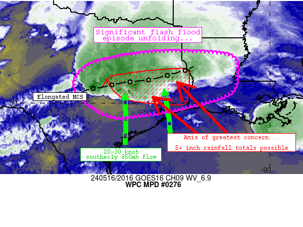
Mesoscale Precipitation Discussion 0276
NWS Weather Prediction Center College Park MD
421 PM EDT Thu May 16 2024
Areas affected...central through southeastern Texas, western
Louisiana
Concerning...Heavy rainfall...Flash flooding likely
Valid 162020Z - 170220Z
Summary...Continued expanse of convective coverage is setting the
stage for widespread, significant flash flood potential across
portions of the discussion area through at least 02Z tonight.
Discussion...Convection continues to expand in coverage both along
an elongated MCS extending from near the Sabine River (near
IER/Natchitoches, LA) westward to near JCT/Junction, TX) and south
of this axis whtin a warm-advection regime across the Austin and
College Station areas. The pre-convective airmass supporting the
ongoing convection is abundantly moist and buoyant (2000+ J/kg
MLCAPE and 2+ inch PW values), supporting very heavy rain rates.
Additionally, the east-west orientation of the MCS (parallel to
flow aloft) and robust cellular development along and south of the
MCS will allow for many areas of training/merging, with at least
1-3 hours of heavy rainfall (longest with southeastward extent)
over areas that have been abundantly wet potentially leading to
another significant flash flood episode eventually.
Continued upscale growth of the MCS is likely through the evening
along with a slow east-southeastward translation of the MCS
occurring through 02Z. 1-2 inch/hr rain rates have already been
observed, and rates should only continue to increase over time in
tandem with increasing convective coverage. Recent runs of the
HRRR seem to have a decent handle on convective evolution, with 5+
inch rainfall totals becoming possible along an axis from near
Temple to Lufkin to Beaumont. Hourly rain rates exceeding 3
inches are also possible at times in this general vicinity.
Again, ground conditions are sensitive areawide given recent
rainfall/wet soils and prior impacts. Significant flash flooding
is expected.
^^Not great news for folks that have been hit hard over the past weeks.
-
don
- Posts: 3106
- Joined: Wed Feb 03, 2010 3:33 pm
- Location: Wichita Falls
- Contact:
I'm not sold on that...models are already creeping precip back in by later next week.(specifically north of I-10) And are showing many disturbances moving over the state through the rest of the month in the flow aloft.Global models have to get closer to the "event's" to have a more accurate depiction of precip as they lack resolution.Stratton20 wrote: ↑ Good news after friday for those folks that have been hammered so hard by the rain the last few weeks, the mexican heat ridge begins to build in next week and looks to stay in place through the end of may, so we should have plenty of time to dry out, though i see alot of upper 90’s to near 100 in the future
-
Stratton20
- Posts: 5612
- Joined: Tue Feb 09, 2021 11:35 pm
- Location: College Station, Texas
- Contact:
Don ah guess I didnt see that, hopefully not north of i-10 again , i feel for those folks just getting absolutely crushed over the last few weeks, but do you think that all this rain we have been seeing could create a lingering weakness over the state in the summer? , more so that could spell trouble for us in the tropics if thats the case
-
DoctorMu
- Posts: 7625
- Joined: Sun Jun 28, 2015 11:58 am
- Location: College Station
- Contact:
MH5 wrote: ↑Thu May 16, 2024 3:33 pm
Mesoscale Precipitation Discussion 0276
NWS Weather Prediction Center College Park MD
421 PM EDT Thu May 16 2024
Areas affected...central through southeastern Texas, western
Louisiana
Concerning...Heavy rainfall...Flash flooding likely
Valid 162020Z - 170220Z
Summary...Continued expanse of convective coverage is setting the
stage for widespread, significant flash flood potential across
portions of the discussion area through at least 02Z tonight.
Discussion...Convection continues to expand in coverage both along
an elongated MCS extending from near the Sabine River (near
IER/Natchitoches, LA) westward to near JCT/Junction, TX) and south
of this axis whtin a warm-advection regime across the Austin and
College Station areas. The pre-convective airmass supporting the
ongoing convection is abundantly moist and buoyant (2000+ J/kg
MLCAPE and 2+ inch PW values), supporting very heavy rain rates.
Additionally, the east-west orientation of the MCS (parallel to
flow aloft) and robust cellular development along and south of the
MCS will allow for many areas of training/merging, with at least
1-3 hours of heavy rainfall (longest with southeastward extent)
over areas that have been abundantly wet potentially leading to
another significant flash flood episode eventually.
Continued upscale growth of the MCS is likely through the evening
along with a slow east-southeastward translation of the MCS
occurring through 02Z. 1-2 inch/hr rain rates have already been
observed, and rates should only continue to increase over time in
tandem with increasing convective coverage. Recent runs of the
HRRR seem to have a decent handle on convective evolution, with 5+
inch rainfall totals becoming possible along an axis from near
Temple to Lufkin to Beaumont. Hourly rain rates exceeding 3
inches are also possible at times in this general vicinity.
Again, ground conditions are sensitive areawide given recent
rainfall/wet soils and prior impacts. Significant flash flooding
is expected.
^^Not great news for folks that have been hit hard over the past weeks.
It's 2 inch per hour stuff coming down now. It reminds me of heavy showers we'd run into on I-10 between Mobile and Pensacola back in the day. A true gully washer here in Texas.
-
DoctorMu
- Posts: 7625
- Joined: Sun Jun 28, 2015 11:58 am
- Location: College Station
- Contact:
Looks like entraining from CLL to Austin. We're looking at high river cresting again from the Colorado, Brazos, Trinity in a few days.
Our house sits on high ground on the block. We're fine. The Lagniappe is I've barely had to run the sprinklers this spring.
Our house sits on high ground on the block. We're fine. The Lagniappe is I've barely had to run the sprinklers this spring.
-
jasons2k
- Posts: 6056
- Joined: Thu Feb 04, 2010 12:54 pm
- Location: Imperial Oaks
- Contact:
Rotation
- Attachments
-
- IMG_1392.png
- (1.68 MiB) Downloaded 2305 times