
Latest forecast track from the NHC aligns with the HAFS-B. Still considerable spread in guidance so swings could still be expected. Hoping the latest recon data that gets ingested in the models this evening will begin to resolve them.
Hurricane Beryl
-
Scott747
- Posts: 1647
- Joined: Tue Feb 23, 2010 9:56 am
- Location: Freeport/Surfside Beach
- Contact:
-
biggerbyte
- Posts: 1429
- Joined: Thu Feb 04, 2010 12:15 am
- Location: Porter, Texas. (Montgomery County)
- Contact:
Some very interesting observations today. So, high pressure looks like it will move off to the east and weaken. Then take a look at the jet stream. There has been occasional chatter about Beryl reaching the Texas coast then either stalling or crawling along. Being a Tropical Storm at the juncture, it isn't going to be as tight.
There could be a lot of rain coming in..Are we going to see another monster? The answer is not likely considering wind shear issues. We are not going to see what we have seen in the eastern caribbean. That was a fluke where conditions in that area were perfect for rapid development.
There could be a lot of rain coming in..Are we going to see another monster? The answer is not likely considering wind shear issues. We are not going to see what we have seen in the eastern caribbean. That was a fluke where conditions in that area were perfect for rapid development.
-
Pas_Bon
- Posts: 923
- Joined: Tue Sep 11, 2018 7:58 am
- Location: League City, TX
- Contact:
If the HWRF is to be believed, it is….
Jamaica->Caymans->Northern tip of the Yucatán->prison (inferred)->Galveston or Freeport
Jamaica->Caymans->Northern tip of the Yucatán->prison (inferred)->Galveston or Freeport
-
AtascocitaWX
- Posts: 164
- Joined: Mon Jun 19, 2017 3:29 pm
- Location: Atascocita,Tx
- Contact:
-
jasons2k

- Posts: 6137
- Joined: Thu Feb 04, 2010 12:54 pm
- Location: Imperial Oaks
- Contact:
-
Cpv17
- Posts: 6940
- Joined: Fri Aug 31, 2018 1:58 pm
- Location: El Campo/Wharton
- Contact:
Through 57 hours, the 18z ICON is slightly stronger and slightly further S than the 12z.
-
Stormlover2020
- Posts: 562
- Joined: Mon Jun 01, 2020 6:04 pm
- Contact:
Icon isn’t budging
-
AtascocitaWX
- Posts: 164
- Joined: Mon Jun 19, 2017 3:29 pm
- Location: Atascocita,Tx
- Contact:
Jason2k what's this about a cat3 ?
-
Stratton20
- Posts: 5699
- Joined: Tue Feb 09, 2021 11:35 pm
- Location: College Station, Texas
- Contact:
ICON at hour 120 looks a little more stronger and south of 12z just a hair, that trajectory looks like it would come in around port arthur if i had to guess
-
Cpv17
- Posts: 6940
- Joined: Fri Aug 31, 2018 1:58 pm
- Location: El Campo/Wharton
- Contact:
Yeah, I’d say High Island to Sabine Pass on the 18z ICON if you were to extrapolate it.
-
AtascocitaWX
- Posts: 164
- Joined: Mon Jun 19, 2017 3:29 pm
- Location: Atascocita,Tx
- Contact:
I see Beryl looks to be weakening some , fighting the TUTT and shear
-
Cromagnum
- Posts: 3051
- Joined: Thu Feb 03, 2011 10:42 pm
- Location: Georgetown
- Contact:
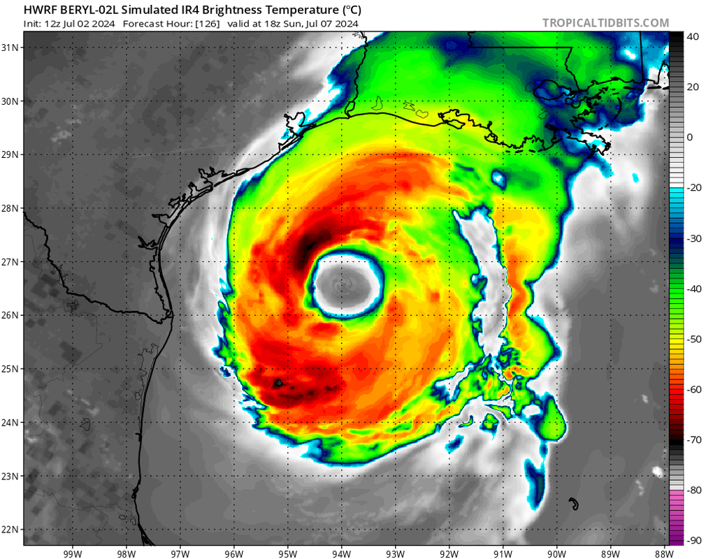
That is a huge eye if that plays out. Around 1 degree of latitude end to end, so practically 70 miles wide.
-
djmike

- Posts: 1856
- Joined: Fri Jan 07, 2011 12:19 pm
- Location: BEAUMONT, TX
- Contact:
Umm no Ill pass. Beaumont doesnt want any part of a direct hit. Lol. Matagorda then northward inland would be ideal and probably beneficial to most of Texas.Stratton20 wrote: ↑Tue Jul 02, 2024 4:28 pm ICON at hour 120 looks a little more stronger and south of 12z just a hair, that trajectory looks like it would come in around port arthur if i had to guess
Mike
Beaumont, TX
(IH-10 & College Street)
Beaumont, TX
(IH-10 & College Street)
-
DoctorMu

- Posts: 7778
- Joined: Sun Jun 28, 2015 11:58 am
- Location: College Station
- Contact:
TUTT shear and land shear will spread Beryl out, just like moving the MOI out on a spinning skater. The arms extend out while she slows her spin. Whe she refeeds over the GoM whe get a bigger storm with more outer rain bands and a looser eye. We'll see.
-
Cpv17
- Posts: 6940
- Joined: Fri Aug 31, 2018 1:58 pm
- Location: El Campo/Wharton
- Contact:
Man, what a difference between the ICON and the other models.
-
Stormlover2020
- Posts: 562
- Joined: Mon Jun 01, 2020 6:04 pm
- Contact:
Well it’s all about how strong it is and where it passes on yuc pen
-
Scott747
- Posts: 1647
- Joined: Tue Feb 23, 2010 9:56 am
- Location: Freeport/Surfside Beach
- Contact:
18z GFS looks similar to the 12z hurricane models. Trough isn't deep enough so it's more of a wnw to nw heading as it approaches ne mex and the border.
-
Stratton20
- Posts: 5699
- Joined: Tue Feb 09, 2021 11:35 pm
- Location: College Station, Texas
- Contact:
Trough looks like it still wants to yank it inland into texas before before turning west
-
djmike
- Posts: 1856
- Joined: Fri Jan 07, 2011 12:19 pm
- Location: BEAUMONT, TX
- Contact:
What days does it pass near Jamaica then YP? Im getting tired of Beryl already. What happened to storm D?
Mike
Beaumont, TX
(IH-10 & College Street)
Beaumont, TX
(IH-10 & College Street)
-
Stratton20
- Posts: 5699
- Joined: Tue Feb 09, 2021 11:35 pm
- Location: College Station, Texas
- Contact:
Reconnaissance flight heading towards the storm, should have fresh data ingested by the 00z models tonight