
346
FXUS64 KHGX 221115
AFDHGX
Area Forecast Discussion
National Weather Service Houston/Galveston TX
615 AM CDT Fri Aug 22 2025
...New AVIATION...
.KEY MESSAGES...
Issued at 1209 AM CDT Fri Aug 22 2025
- Showers/thunderstorms continue today, some capable of producing
locally heavy rainfall possible.
- Rain chances lower over the weekend, but should rise again next
week as another weak boundary approaches the area.
&&
.DISCUSSION...
Issued at 1209 AM CDT Fri Aug 22 2025
Another day of wetter conditions is on the tap today as a weak
surface boundary remains in the vicinity while a number of
shortwaves pass overhead. Combined with deep moisture and the slew
of mesoscale boundary interactions, SE Texas should see
conditions similar to that of yesterday. CAMs are showing greater
coverage with showers/storms this afternoon than in previous
runs, though it still may be a tad underdone. The environment
remains conducive for high precipitation efficiency, which may
result in some strong downpours and possibly locally heavy
rainfall at times. WPC still has SE Texas under a Marginal (level
1/4) Risk of Excessive rainfall for today, generally for areas
south of Huntsville and closer to the coast. Most areas should see
less than half an inch of rainfall, though any stronger storms
could produce locally higher totals up to 2-3" in some isolated
spots, much like what occurred yesterday.
Ridging over the Desert Southwest should strengthen over the
weekend. Saturday could still see some modest shower/storm coverage,
especially as models are now keeping deep moisture in place over SE
Texas a tad longer than previously forecast. CAMs may still be
underdoing activity during this period slightly, though most
showers/storms should be confined to the coastline/nearshore
waters. Still, PoPs trend downward throughout the course of the
weekend, with high temperatures gradually trending upwards. An
upper level low/trough over the Great Lakes/Quebec/Ontario is
progged to push another frontal boundary & round of shortwaves
towards SE Texas around the Tuesday/Wednesday next week. With
this, the forecast reverses course, trading heat for greater rain
chances through Thursday as this weak boundary stalls out over our
area.
03
&&
.AVIATION...
(12Z TAF Issuance)
Issued at 606 AM CDT Fri Aug 22 2025
Trof axis and remnant outflows lit back up near the coast
overnight. Some rain and isolated thunder extends into the metro
area. Suspect we`ll see a lull in activity as we head into mid
morning followed by more scattered development inland this
afternoon...which should eventually sag back toward the metro area
later in the day and coastal areas this evening. Hires models have
been struggling to keep up, but considering the pattern remains
about the same and most is driven on the small scale and boundary
interactions, it`s not overly surprising. The more robust cells
have had a history of producing strong wind gusts, reduced
visibility in heavy downpours...and today will likely not be much
different. So other than knowing there will be some storms
around, pinpointing the specifics at any individual terminal is
difficult to say the least. Outside of convective activity, VFR
conditions and light winds will be the rule. Rinse/repeat tonight-
Saturday. 47
&&
.MARINE...
Issued at 1209 AM CDT Fri Aug 22 2025
Conditions will be fairly calm with 1-3 ft seas and seabreeze-
landbreeze driven winds around 5-10 knots (offshore/northwesterly
early in the morning, then onshore/southeasterly in the afternoon).
Isolated to scattered showers and storms will be a daily
possibility, primarily during the daytime hours. Coverage of
showers/storms should be greatest today and early this weekend
due to a weak boundary near the coast. Rain chances later
decrease over the weekend. Locally higher winds and seas are
expected near any thunderstorms that develop.
03
&&
.PRELIMINARY POINT TEMPS/POPS...
College Station (CLL) 92 73 93 72 / 40 10 20 10
Houston (IAH) 91 75 91 75 / 60 40 60 20
Galveston (GLS) 90 80 90 81 / 70 70 70 40
&&
.HGX WATCHES/WARNINGS/ADVISORIES...
TX...None.
GM...None.
&&
$$
DISCUSSION...03
AVIATION...47
MARINE...03
August 2025

Today is the third time this week where a 70% chance of rain had been advertised for days and then the day of, the morning update posts and it’s lowered, again.

Seabreeze or not Seabreeze?
I'll assume the action will be south of 1*5.
I'll assume the action will be south of 1*5.
Mesoscale Precipitation Discussion 0974
NWS Weather Prediction Center College Park MD
1212 PM EDT Fri Aug 22 2025
Areas affected...southeast Texas, southwestern Louisiana
Concerning...Heavy rainfall...Flash flooding likely
Valid 221611Z - 222211Z
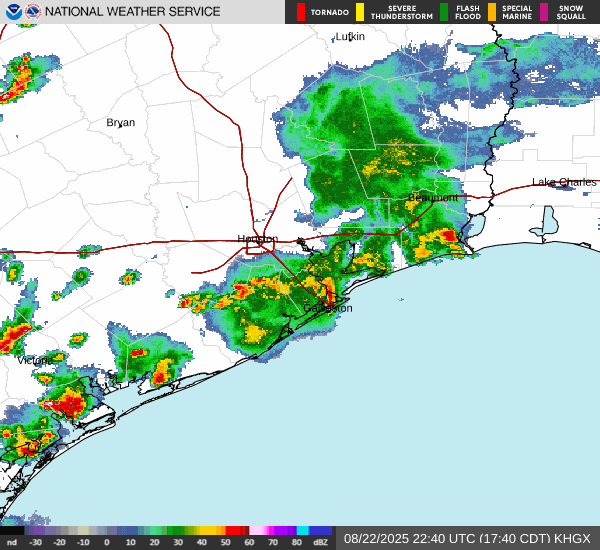
Summary...Slow-moving convection continues to expand in coverage this morning, with areas of 2-3 inch/hr rain rates becoming likely beneath the strongest storms. Flash flooding is expected.
Discussion...Deep convection has been focused mainly along coastal areas of Texas and Louisiana for most of the morning. Over the past hour or so, storms has materialized just inland across the discussion area (nearer to I-10) due to 1) strong surface heating/destabilization, 2) abundant moisture (2.3 inch PW), and 3) convergence along a weak front across the region (generally from Houston Metro east to Baton Rouge, LA). Kinematics/steering flow aloft are very weak (<5 knots), suggestive of slow-moving cells/clusters that are outflow dominant and propagate erratically through the afternoon. A few of these clusters were forming near Lake Charles and just north of Houston while already producing spots of 1-2 inch/hr rain rates.
With continued surface heating, convective clusters are expected to expand in coverage. The orientation of storms relative to outflow from prior activity over the Gulf suggests potential for several cell mergers as well. 2-3 inch/hr rain rates will eventually materialize, and may impact populated/flashy urban centers such as Lake Charles, Beaumont, and Houston through 20Z. FFGs near those areas are as low as 1-1.5 inches/hr and should be readily exceeded. Surrounding areas have higher FFGs (in the 3 inch/hr range) that should still be exceeded as stronger convection develops through the morning and early afternoon. Areas of flash flooding are expected given the developing scenario.
Cook
...Please see www.wpc.ncep.noaa.gov for graphic product...
ATTN...WFO...CRP...EWX...HGX...LCH...
ATTN...RFC...FWR...ORN...NWC...
NWS Weather Prediction Center College Park MD
1212 PM EDT Fri Aug 22 2025
Areas affected...southeast Texas, southwestern Louisiana
Concerning...Heavy rainfall...Flash flooding likely
Valid 221611Z - 222211Z
Summary...Slow-moving convection continues to expand in coverage this morning, with areas of 2-3 inch/hr rain rates becoming likely beneath the strongest storms. Flash flooding is expected.
Discussion...Deep convection has been focused mainly along coastal areas of Texas and Louisiana for most of the morning. Over the past hour or so, storms has materialized just inland across the discussion area (nearer to I-10) due to 1) strong surface heating/destabilization, 2) abundant moisture (2.3 inch PW), and 3) convergence along a weak front across the region (generally from Houston Metro east to Baton Rouge, LA). Kinematics/steering flow aloft are very weak (<5 knots), suggestive of slow-moving cells/clusters that are outflow dominant and propagate erratically through the afternoon. A few of these clusters were forming near Lake Charles and just north of Houston while already producing spots of 1-2 inch/hr rain rates.
With continued surface heating, convective clusters are expected to expand in coverage. The orientation of storms relative to outflow from prior activity over the Gulf suggests potential for several cell mergers as well. 2-3 inch/hr rain rates will eventually materialize, and may impact populated/flashy urban centers such as Lake Charles, Beaumont, and Houston through 20Z. FFGs near those areas are as low as 1-1.5 inches/hr and should be readily exceeded. Surrounding areas have higher FFGs (in the 3 inch/hr range) that should still be exceeded as stronger convection develops through the morning and early afternoon. Areas of flash flooding are expected given the developing scenario.
Cook
...Please see www.wpc.ncep.noaa.gov for graphic product...
ATTN...WFO...CRP...EWX...HGX...LCH...
ATTN...RFC...FWR...ORN...NWC...
- Attachments
-
- 32E724F1-D0FE-4FBE-BD17-31DBBC1D6EC0.png (1.98 MiB) Viewed 20019 times
Satellite and stationary front.
- Attachments
-
- IMG_4114.jpeg (257.25 KiB) Viewed 20011 times

In Lake Charles at the Nugget for the lady’s 50th.
No pool for us
No pool for us

-
tireman4

- Global Moderator

- Posts: 6543
- Joined: Wed Feb 03, 2010 9:24 pm
- Location: Humble, Texas
- Contact:
600
FXUS64 KHGX 221650
AFDHGX
Area Forecast Discussion
National Weather Service Houston/Galveston TX
1150 AM CDT Fri Aug 22 2025
...New DISCUSSION, MARINE...
.KEY MESSAGES...
Issued at 1056 AM CDT Fri Aug 22 2025
- Showers/thunderstorms continue today with locally heavy rainfall
possible. Areas of minor flooding is expected, but a few
instances of flash flooding cannot be rule out
- Rain chances lower over the weekend, but isolated showers and
storms will still be possible.
- Increase in coverage of the showers and storms should rise again
midweek next week as another weak boundary approaches the area.
&&
.DISCUSSION...
Issued at 1056 AM CDT Fri Aug 22 2025
A stationary boundary situated over the region has led to the
development of scattered showers and thunderstorms this morning,
which are expected to persist through at least this evening.
Exactly where the storms are developing is largely dependent on
boundary interactions from preceding storms, so really almost
anywhere in the CWA will have a fair shot of seeing a thunderstorm
today. And where these storms develop, they are producing locally
heavy rainfall with rain rates of 1-3"+ per hour, and storm
movement is almost zero. This will lead to areas of minor
flooding, mainly ponding in area of poor drainage, but a few
instances of flash flooding cannot be rule out if rainfall is
heavy enough or if multiple storms move over the same area. The
trend today has been that the storms that do develop and produce
heavy rainfall end up raining themselves out within 30-45 minutes
of development, which has helped ward off most flooding concerns
so far. Thunderstorm activity is expected to wane after sunset
with the loss of daytime heating, but some redevelopment over the
coast is expected overnight tonight.
The near stationary boundary over the area today will still be
near the coast tomorrow, and with PWATs still around 2", it is
likely that there will be additional pop-up showers and
thunderstorms. Coverage will likely peak during the afternoon
hours along the coast where the highest PWATs are located. Rain
chances lower Sunday and Monday, but do not become zero, and
isolated afternoon is possible along the sea breeze each day.
Another weak, slow moving boundary is expected to approach the
region Tuesday into Wednesday of next week leading to an increase
in shower and thunderstorm chances. This boundary may eventually
end up stalling along the Gulf coast, which combined with weak
disturbances embedded in the northwesterly flow aloft will lead to
continued rain chances through the remainder of the week.
As for temperatures, Sunday and Monday will likely be the warmest
days of the forecast with the least coverage of showers and storms
expected leading to temperatures rising into the mid 90s for much
the area area. Otherwise, expected continued summer-time heat
with highs generally in the 90s and lows in the 70s.
Fowler
&&
.AVIATION...
(12Z TAF Issuance)
Issued at 606 AM CDT Fri Aug 22 2025
Trof axis and remnant outflows lit back up near the coast
overnight. Some rain and isolated thunder extends into the metro
area. Suspect we`ll see a lull in activity as we head into mid
morning followed by more scattered development inland this
afternoon...which should eventually sag back toward the metro area
later in the day and coastal areas this evening. Hires models have
been struggling to keep up, but considering the pattern remains
about the same and most is driven on the small scale and boundary
interactions, it`s not overly surprising. The more robust cells
have had a history of producing strong wind gusts, reduced
visibility in heavy downpours...and today will likely not be much
different. So other than knowing there will be some storms
around, pinpointing the specifics at any individual terminal is
difficult to say the least. Outside of convective activity, VFR
conditions and light winds will be the rule. Rinse/repeat tonight-
Saturday. 47
&&
.MARINE...
Issued at 1056 AM CDT Fri Aug 22 2025
A diffuse frontal boundary will meander along the coast through
Saturday, but with a very weak pressure gradient in place we will
continue to see a prevailing landbreeze and seabreeze
circulation. Expect light offshore wind directions late at night
and in the mornings followed by light onshore winds in the
afternoon and evenings with the passing seabreeze. A daily risk of
scattered showers and thunderstorms continues through the weekend
and through much of next week. Coverage will likely be the lowest
Sunday into Monday as our current stalled boundary moves out of
the area, but then increase Tuesday and beyond as another diffuse
boundary moves in from the north. Locally higher winds and
rougher seas will be possible in the vicinity of any thunderstorm.
Fowler
&&
.PRELIMINARY POINT TEMPS/POPS...
College Station (CLL) 74 93 72 95 / 20 40 10 10
Houston (IAH) 76 91 75 94 / 50 40 10 30
Galveston (GLS) 80 88 81 90 / 50 70 50 50
&&
.HGX WATCHES/WARNINGS/ADVISORIES...
TX...None.
GM...None.
&&
$$
DISCUSSION...Fowler
AVIATION...47
MARINE...Fowler
Heavey rainfall at A&M but the donut hold held at home. Maybe a tenth of an inch.
1.97”
Morning radar:
- Attachments
-
- IMG_4158.png (5.11 MiB) Viewed 19742 times
Welp. We've made it to the first college football Sunday without a 100°F day at the College Station airport. That doesn't mean we won't have some version of summer until December - but good enough for now. Sign me up for this every meteorological summer in CLL.
We did not receive much rain (maybe a tenth) over the past two days. Temps in the mid 90s until mid-week when a FROPA lurks around the area with a slight chance of rain.
We did not receive much rain (maybe a tenth) over the past two days. Temps in the mid 90s until mid-week when a FROPA lurks around the area with a slight chance of rain.
I only received .45” this week. Not gonna complain though, better than nothing.
-
tireman4
- Global Moderator
- Posts: 6543
- Joined: Wed Feb 03, 2010 9:24 pm
- Location: Humble, Texas
- Contact:
943
FXUS64 KHGX 251047
AFDHGX
Area Forecast Discussion
National Weather Service Houston/Galveston TX
547 AM CDT Mon Aug 25 2025
...New AVIATION...
.KEY MESSAGES...
Issued at 1127 PM CDT Sun Aug 24 2025
- Drier conditions will continue on Monday, although isolated
showers and thunderstorms are still possible near the coast.
- High temperatures will remain in the mid 90s inland and the
lower 90s over the coasts on Monday. Isolated spots could reach
the upper 90s. Heat indices will be in the lower 100s.
- Chance of showers and thunderstorms should rise again on Tuesday
and Wednesday as a weak boundary approaches from the north-
northeast.
&&
.DISCUSSION...
Issued at 1127 PM CDT Sun Aug 24 2025
The drier weather pattern will continue on Monday as drier air
persists over Southeast Texas and the mid level high pressure
currently over Arizona and New Mexico continues to move
southeastward further into New Mexico and West-Northwest Texas. If
any storms were to develop on Monday, it will likely be isolated
in nature. The high temperatures will be in the mid 90s for most
of the inland portions, while locations over and near the coasts
will be in the lower 90s. Thanks to the drier air in place, heat
indices will remain in the lower 100s, although some isolated
spots could have heat indices as high as 107 deg F for an hour or
two. Regardless, it summer and its...just hot...thus, please
continue to practice heat safety if you plan to work or spend time
outdoors.
We are still expecting a change in the weather pattern Tuesday
into Wednesday as a weak boundary moves in from the north-
northeast and meanders over Southeast Texas through sometime
Thursday. Although there is the potential for increased showers
and thunderstorms with the help of the boundary, the mid level
high is expected to move over Central Texas on Tuesday with mid
level heights increasing to around 594 dams over Southeast Texas.
Too add to it, models have backed off a little on how much
moisture we recover mid-week. Yesterday, models suggested PWs
rising to 1.8-2.2 inches starting on Tuesday, whereas today they
suggest PWs closer to 1.6-2.1 inches. Thus, I still believe we
will have to see where the weak boundary moves and how much of an
influence it will have over our local area in order to determine
if storms will be isolated or scattered to widespread. The weak
boundary is expected to move northward on Thursday, allowing the
mid level high to be the stronger weather feature and limiting
storm chances. The high will weaken Friday into the upcoming
weekend, and a weak cold front might push across Southeast Texas
sometime Saturday into Sunday, which would rise our rain chances
once again.
At this time, we are not expected significant flooding for this
week, however, some storms could become efficient rain makers and
result in periods of moderate to heavy rainfall. This may lead to
ponding of water along roadways and areas of poor drainage. Thus,
be sure to check the radar and traffic conditions before you start
your commute as heavy rain and frequent lightning could lead to
minor driving hazards. In response to the increase in rain and
cloud coverage, we are expecting temperatures to lower back into
the upper 80s to lower 90s Tuesday through the upcoming weekend.
Cotto
&&
.AVIATION...
(12Z TAF Issuance)
Issued at 533 AM CDT Mon Aug 25 2025
VFR conditions & light winds will be the rule again today &
tonight. Seabreeze might make it into the Houston terminals later
in the afternoon bringing some SE winds. Can`t rule out an
isolated rouge tstm or two, but chances are too low to include in
the TAFs at this time. 47
&&
.MARINE...
Issued at 1127 PM CDT Sun Aug 24 2025
Light onshore winds will return late Monday and continue into the
end of the week. Winds may become more easterly on Wednesday as a
weak boundary moves across the region. Seas will generally be
between 1-2 feet, but may rise to 2-3 feet late Wednesday into
Friday.
Slight chances for showers and thunderstorm on Monday, increasing
in coverage Tuesday and Wednesday as the weak boundary pushes
through Southeast Texas. Isolated chances for storms are expected
Thursday and Friday. Storm coverage is expected to increase again
next weekend with the possibility of a weak cold frontal passage.
Strong variable winds/gusts and higher seas are possible in and
around strong thunderstorms and outflow boundaries.
Cotto
&&
.PRELIMINARY POINT TEMPS/POPS...
College Station (CLL) 98 72 96 73 / 0 0 20 10
Houston (IAH) 98 77 96 75 / 0 0 40 10
Galveston (GLS) 93 83 92 82 / 10 10 40 40
&&
.HGX WATCHES/WARNINGS/ADVISORIES...
TX...None.
GM...None.
&&
$$
DISCUSSION...Cotto
AVIATION...47
MARINE...Cotto
-
tireman4
- Global Moderator
- Posts: 6543
- Joined: Wed Feb 03, 2010 9:24 pm
- Location: Humble, Texas
- Contact:
411
FXUS64 KHGX 251553
AFDHGX
Area Forecast Discussion
National Weather Service Houston/Galveston TX
1053 AM CDT Mon Aug 25 2025
...New DISCUSSION, MARINE...
.KEY MESSAGES...
Issued at 1041 AM CDT Mon Aug 25 2025
- Isolated showers and thunderstorms are still possible near the
coast, but overall today will be rain free. High temperatures
will rise into the mid to upper 90s inland and the lower 90s
over the coasts with heat indices will be in the lower 100s.
- Chance of showers and thunderstorms should rise again on Tuesday
and Wednesday as a weak boundary approaches (but likely doesn`t
push through) from the north-northeast. Additional rain chances
are expected through the weekend.
&&
.DISCUSSION...
Issued at 1041 AM CDT Mon Aug 25 2025
High pressure building over the Southern Plains will lead to
continued drier, but hotter, conditions across the area today.
PWATs are expected to be down to around 1.2-1.5" this afternoon,
which is low for this time of year. Drier air, increasing heights,
and plenty of sunshine will lead to the return of mid to upper 90s
across most of the region (and I wouldn`t be shocked if a few
isolated areas reached the 100 degree mark). While dew points are
expected to be lower today, the higher actual temperatures will
still lead to heat indices rising into the lower triple digits
across the area. With the drier air in place, rain chances today
will be very low - although can`t out rule a brief isolated shower
or storm during the afternoon along the coast.
PWATs begin to rise tomorrow, up to around 1.7-2", in response to
a weak boundary approaching from the northeast. This increase in
moisture will lead to better chances of afternoon showers and
thunderstorms. The aforementioned boundary that approaches from
the north tomorrow may end up stalling within, or just to the
northeast, by Wednesday. This will keep those higher PWATs in
place across SE Texas leading to continued chances of daily
showers and thunderstorms starting out along the coast in the
morning, then moving inland through the day. High temperatures
across the area Tuesday through Friday are expected to be in the
low to mid 90s, with some areas reaching the upper 90s
occasionally.
Another boundary is expected to approach, and potentially move
through, the area over the weekend. This will lead to greater
chances of showers and thunderstorms and cooler temperatures.
Fowler
&&
.AVIATION...
(12Z TAF Issuance)
Issued at 533 AM CDT Mon Aug 25 2025
VFR conditions & light winds will be the rule again today &
tonight. Seabreeze might make it into the Houston terminals later
in the afternoon bringing some SE winds. Can`t rule out an
isolated rouge tstm or two, but chances are too low to include in
the TAFs at this time.
47
&&
.MARINE...
Issued at 1041 AM CDT Mon Aug 25 2025
Light onshore winds, around 10kt, and low seas will prevail
through this week. An isolated shower or thunderstorm is
possible today, but rain chances increase beginning Tuesday
through the end of the week as a weak boundary approaches from the
north. Another boundary may slide through the area over the
weekend leading to scattered to widespread showers and
thunderstorms. Expect gusty, variable winds and locally higher
seas near any thunderstorms that develop this week.
Fowler
&&
.PRELIMINARY POINT TEMPS/POPS...
College Station (CLL) 98 72 96 73 / 0 0 10 10
Houston (IAH) 99 76 96 77 / 0 0 30 20
Galveston (GLS) 90 83 89 82 / 10 10 40 40
&&
.HGX WATCHES/WARNINGS/ADVISORIES...
TX...None.
GM...None.
&&
$$
DISCUSSION...Fowler
AVIATION...47
MARINE...Fowler
-
MontgomeryCoWx

- Posts: 2628
- Joined: Wed Dec 14, 2011 4:31 pm
- Location: Weimar, TX
- Contact:
Summer still sucks, but 2025 Summer less suck than most this decade.
We have reached a maxima in Solar activity and will now be headed towards a Solar min this next decade.
We have reached a maxima in Solar activity and will now be headed towards a Solar min this next decade.
Team #NeverSummer


Summer 2025 is better than past summers. Things are starting to cool down from here.MontgomeryCoWx wrote: ↑Mon Aug 25, 2025 6:52 pm Summer still sucks, but 2025 Summer less suck than most this decade.
We have reached a maxima in Solar activity and will now be headed towards a Solar min this next decade.
-
tireman4
- Global Moderator
- Posts: 6543
- Joined: Wed Feb 03, 2010 9:24 pm
- Location: Humble, Texas
- Contact:
944
FXUS64 KHGX 261104
AFDHGX
Area Forecast Discussion
National Weather Service Houston/Galveston TX
604 AM CDT Tue Aug 26 2025
...New AVIATION...
.KEY MESSAGES...
Issued at 1058 PM CDT Mon Aug 25 2025
- Chance of showers and thunderstorms return to the forecast today.
- A weak cold front will push across the area late Friday into
Saturday will once again increase our chances for showers and
thunderstorms.
- High temperatures will remain in the lower to mid 90s through
the end of the work week, then possibly decrease a couple of
degrees over the weekend.
&&
.DISCUSSION...
Issued at 1058 PM CDT Mon Aug 25 2025
We will begin to recover some of our PWs on Tuesday and Wednesday
as some pockets of low level moisture begin to filter into
portions of Southeast Texas. PWs on Tuesday should range between
1.6-2.0" and between 1.8-2.1" on Wednesday. A weak frontal
boundary is progged to move in from the north northeast on Tuesday
and stall over or near Southeast Texas through sometime late
Wednesday. This feature will help bring higher rain chances over
our region, however, the mid level high pressure currently over
Texas is expected to remain in place, which could limit some of
the rain development. Another thing to note is that models are
indicating dry air along the mid levels for areas southwest of the
Piney Woods region on Tuesday. Thus, there is still some
uncertainty on how much influence the frontal boundary will have,
whether or not it will provide enough lift to combine with the
moisture and instability to result in scattered showers and
thunderstorms. For now, continued with afternoon scattered showers
and thunderstorms, mainly for areas south of the Brazos Valley
and Piney Woods region. That being said, I wouldn`t go completely
dry for the Piney Woods region, given that models hint at PWs
closer to 2.0" over that area while the boundary may be moving
near or over that location.
A better setup for showers and thunderstorms can be expected on
Wednesday as additional moisture filters in, the mid levels begin
to saturate more, and the weak boundary continues to meander over
or near Southeast Texas. We can expect to see most of the shower
and thunderstorm activity near and south of I-10 in the morning
and then expanding further northward during the afternoon and
evening hours. Rain chances will gradually decrease later in the
evening to early night hours as heating and instability decreases
and the boundary ejects north northeastward.
Slightly less development of showers and thunderstorms is
expected on Thursday with the mid level high pressure being the
dominant feature as the boundary moves further away from our
region. Regardless, moisture and instability may still be
sufficient for isolated to possibly scattered storms, in
particular during the mid morning to late afternoon hours.
Rain chances look to increase again Friday and into the upcoming
weekend as another (possibly stronger) frontal boundary pushes
into the central portions of Texas sometime Friday morning and
across Southeast Texas later on Friday or early Saturday. The mid
level high pressure will be weakening and several pulses of
moisture will move into our local area, possibly rising our PWs to
1.8-2.3" for many locations Friday into Sunday. We may also have
a few vort maxes passing through the region during the
aforementioned days. Thus, it looks to be a great setup for
Southeast TX to have several rounds of showers and thunderstorms
Friday into Sunday. Given the amount of moisture we could have
over us during those days, we might see some storms producing
heavy rainfall with rain rates of 2-3 inches per hour. Ponding of
water along roadways and poor drainage areas is not out of the
question.
With respect to temperatures, we will continue to see high
temperatures in the lower to mid 90s through the end of the work
week. Temperatures could cool down during the upcoming weekend as
the frontal boundary moves through and we might see highs in the
upper 80s to lower 90s if it does so.
Cotto
&&
.AVIATION...
(12Z TAF Issuance)
Issued at 600 AM CDT Tue Aug 26 2025
With the return of some deeper Gulf moisture, we`ll see some
isolated to scattered storms today, primarily along the coast this
morning and in the afternoon further inland as the seabreeze and
daytime heating work their magic. Outside of any tstm activity,
VFR conditions and a developing SE wind will prevail. Activity
generally dissipates after sunset, followed by scattered
redevelopment near the coast and offshore later tonight and Wed
morning. 47
&&
.MARINE...
Issued at 1058 PM CDT Mon Aug 25 2025
Light onshore winds and seas of 3 feet or less are expected for
much of the forecast period. Winds may become more easterly on
Wednesday as a weak boundary moves across the region.
Chance for showers and thunderstorms will increase Tuesday and
Wednesday as the weak boundary moves across Southeast Texas.
Chances will slightly decrease on Thursday but will increase
again Friday into the upcoming weekend as another, stronger,
boundary moves across the region. Although winds are generally
expected to stay below 15 KTS, strong thunderstorms and associated
outflow boundaries could lead to stronger winds and gusts and
higher seas.
Cotto
&&
.PRELIMINARY POINT TEMPS/POPS...
College Station (CLL) 96 74 95 74 / 20 10 40 0
Houston (IAH) 96 77 94 77 / 40 20 50 10
Galveston (GLS) 92 82 91 83 / 30 40 50 20
&&
.HGX WATCHES/WARNINGS/ADVISORIES...
TX...None.
GM...None.
&&
$$
DISCUSSION...Cotto
AVIATION...47
MARINE...Cotto
Modest chance of rain beginning tomorrow through the weekend as 2 boundaries move through. The weekend FROPA has a little oomph here north of Hwy 1*5. We have mid to upper 80s beginning Saturday. Until then the usual late August semi-suck, but a chance of some raindrops.