
Winter...
https://youtu.be/Ls1dqc-FLTQ?si=6mDYA-WmtSpWOI8z
When will severe season start?
February 2026
-
DoctorMu

- Posts: 7765
- Joined: Sun Jun 28, 2015 11:58 am
- Location: College Station
- Contact:
-
tireman4

- Global Moderator

- Posts: 6900
- Joined: Wed Feb 03, 2010 9:24 pm
- Location: Humble, Texas
- Contact:
-
Stratton20
- Posts: 5695
- Joined: Tue Feb 09, 2021 11:35 pm
- Location: College Station, Texas
- Contact:
Hopefully we can skip severe weather season
-
sambucol

- Posts: 1243
- Joined: Wed Feb 03, 2010 5:43 pm
- Location: Mont Belvieu
- Contact:
And maybe skip getting a hurricane this year, too.
-
DoctorMu
- Posts: 7765
- Joined: Sun Jun 28, 2015 11:58 am
- Location: College Station
- Contact:
It's a pleasant evening up in the Brazos Valley this evening as temps slide into the 60s and DPs into the upper 40s. We had some nice sun and mild temps. Saturday looks like our best chance of significant rain in a while.
Return flow on Friday with Saturday as our best chance of rain with the next FROPA. Good lift expect here N of Hwy 1*5.
Overall, Gainesville, FL has a better 7-10 day forecast, but it's doable for the next week.
Area Forecast Discussion
National Weather Service Houston/Galveston TX
524 PM CST Wed Feb 11 2026
...New AVIATION...
.KEY MESSAGES...
- A weak cold front will stall near the coastal locations tonight,
then slowly lift as a warm front on Thursday. Expect warmer
conditions Thursday into Friday.
- A stronger system is forecast to arrive Saturday, bringing the
potential for scattered to widespread showers and storms. While
confidence in rainfall is increasing, specific details on timing
and total amounts remain uncertain. Please consider alternate
plans for outdoor activities, if able.
- Tranquil conditions are expected Sunday into early next week.
&&
.DISCUSSION...
Issued at 1201 PM CST Wed Feb 11 2026
The weak cold front is currently making its way southward across
the coastal locations of Southeast Texas. Areas of showers mainly
along the frontal boundary will continue to develop this
afternoon, but if the front has enough push to make it further
into the coastal waters, it would keep much of the shower activity
over the Gulf. If it stalls near the coast, then expect a few more
isolated showers near the coast along with the potential for some
coastal and sea fog tonight. The weak boundary will linger over
or near the coastal areas tonight, however, the cooler and drier
air behind the front will be able to push over areas north of I-10
and allow for slightly lower temperatures overnight. We will see
lows in the upper 40s to lower 50s over the Brazos Valley and
Piney Woods region, the mid to upper 50s for the rest of the
inland portions, and the upper 50s to lower 60s along the coast.
Now, the bad news is that ridging will build overhead and the
boundary will begin to slowly lift north-northeastward on Thursday
as a warm front, and could bring southwest to west wind flow over
Southeast Texas. This would lead to warmer daytime temperatures with
highs peaking in the upper 70s to lower 80s for the inland areas and
in the lower to mid 70s along the coasts on Thursday. Once the front
exits to our northeast, warm and humid conditions will prevail
Thursday night into Friday as our typical south to southeasterly
wind flow returns. Our lows will be back in the 60s and the highs
for Friday look to stay in the upper 70s to lower 80s range.
Now the main headliner for this forecast package is this
Saturday`s weather pattern (Valentine`s Day and we know that
Houston has no luck with holiday weather events). A mid to upper
level trough currently over the eastern Pacific will progress
eastward and make its way across the Southern Plains sometime late
Friday into Saturday. A surface low and associated cold front
will then push into the northern and central portions of Texas by
Saturday morning. We could see isolated to scattered showers and
isolated thunderstorms starting late Friday night, increasing
early Saturday morning as the front progress towards the Brazos
Valley region and increases lift. Fairly good moisture convergence
could occur just ahead of the front and models have been fairly
consistent since yesterday with bringing scattered to widespread
showers and thunderstorms for much of Southeast Texas throughout
the day Saturday. This could lead to some ponding of water along
roadways and poor drainage areas. There might also be the
potential for strong to possibly severe storms. We are keeping an
eye on the model trends and looking into the timing and location
of severe weather impacts, if any. If you have any outdoor
plans/surprises for Valentines Day, continue to monitor the
forecast and weather updates and consider alternate plans if able.
At the moment, the cold front is progged to exit our local area
rather quickly sometime Saturday evening or Saturday night. Drier
air will follow behind the front, ending our chance for rain.
Tranquil weather conditions on Sunday and prevail through at least
early next week.
Cotto
&&
-
DoctorMu
- Posts: 7765
- Joined: Sun Jun 28, 2015 11:58 am
- Location: College Station
- Contact:
-
Cpv17
- Posts: 6934
- Joined: Fri Aug 31, 2018 1:58 pm
- Location: El Campo/Wharton
- Contact:
Not concerned about hurricane season this year if there’s going to be an El Niño. Of course we could still always get a weak sheared TS though.
-
Cpv17
- Posts: 6934
- Joined: Fri Aug 31, 2018 1:58 pm
- Location: El Campo/Wharton
- Contact:
Lovely
-
suprdav2
- Posts: 134
- Joined: Thu Feb 04, 2010 5:39 pm
- Location: Cypress, TX
- Contact:
-
DoctorMu
- Posts: 7765
- Joined: Sun Jun 28, 2015 11:58 am
- Location: College Station
- Contact:
True enough.
Unfortunately, it only takes one, though. Last season was predicted to be above normal, but almost nothing for our end of the Gulf.
-
DoctorMu
- Posts: 7765
- Joined: Sun Jun 28, 2015 11:58 am
- Location: College Station
- Contact:
-
DoctorMu
- Posts: 7765
- Joined: Sun Jun 28, 2015 11:58 am
- Location: College Station
- Contact:
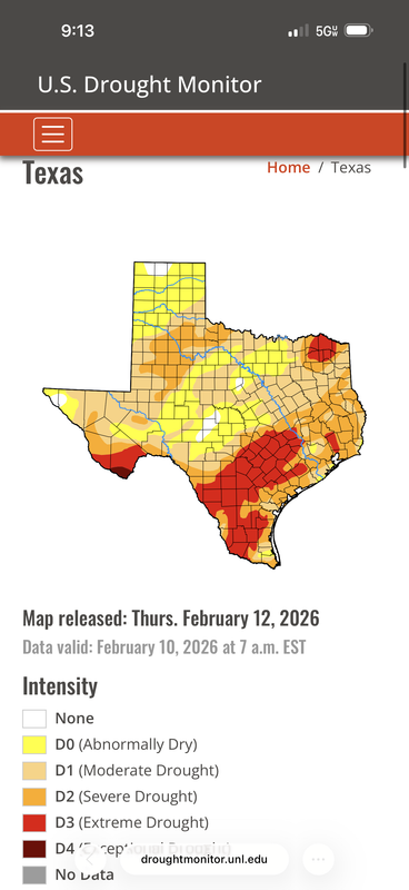
NWS has 100% chance of rain Saturday afternoon, but NAM looked a bit busty.
RGEM looks better. Not a drought buster, but decent.

https://www.tropicaltidbits.com/analysi ... cus_61.png
Area Forecast Discussion
National Weather Service Houston/Galveston TX
448 AM CST Thu Feb 12 2026
...New AVIATION...
.KEY MESSAGES...
- Expect temperatures to climb into the mid 70s to low 80s through
Friday, with increasing humidity and likely fog.
- A stronger system is forecast to arrive late Friday into the
weekend, bringing the potential for scattered showers and
thunderstorms. Heavy rainfall and isolated storms will be
possible.
- Conditions will turn drier and warm, with more comfortable
humidity levels from Sunday into early next week.
&&
.DISCUSSION...
Issued at 1202 AM CST Thu Feb 12 2026
In the near term, a weak cold front remains nearly stationary just
south of I-10. Given the light winds, lingering moisture and a
narrow dewpoint depression of only 0 to 2 degF, areas of fog cannot
be ruled out through mid-morning.
A ridge of high pressure is building in today, leaving us with a
warmer airmass. At the surface, a weak warm front will lift north
through the day, resulting in warmer conditions this afternoon. The
good news is that it won`t be as humid, especially further inland.
However, some passing very light showers cannot be ruled out this
afternoon along the coastal counties. Some weak shortwaves embedded
in the northwest flow aloft will be riding along the ridge. This
upper forcing combined with daytime heating and lingering low-level
moisture will be enough to produce some light showers. Highs will
range from the mid 70s to low 80s. Friday will be dry, turning
slightly humid as southerly winds return.
The next weather-maker arrives this Valentine`s weekend as a strong
upper level trough tracks across the Southern/Central Plains.
Deterministic solutions, including the NAM are now in better
consensus about timing of this wave, suggesting increasing rain
chances mainly from Saturday afternoon through the night. The
exception is the CMC, which shows a more progressive wave, exiting
the region by early Saturday evening.
Discrepancies remain regarding the strength and evolution of this
system, and consequently, the location of the best dynamics and
forcing. Based on latest guidance, rain chances are expected across
all of SE TX, with the highest probabilities along and north of the
I-10 corridor. It is important to point out that the axis of highest
QPF will change as this system evolves across the Southern Plains
and West TX.
Regarding heavy rainfall and severe weather potential: southerly
warm and humid surface flow, paired with dewpoints in the upper 60s
and increasing instability, will be conducive for some strong storms
across the region. As the associated surface front moves through,
there is also the potential for training storms, which could lead to
minor street flooding or ponding. This could limit destabilization
across the region IF the wave shifts further south, bringing more
widespread precipitation to our area. Conversely, will continue to
monitor for strong to low-end severe thunderstorms, mainly
coinciding with the peak of daytime heating and surface convergence
(with the FROPA)in the afternoon and evening. If this scenario
verifies, upper jet dynamics and increasing PVA on the nose of a
strengthening LLJ will support isolated strong storms. Again,
uncertainty remains high regarding the strength and exact location
of the strongest storms and/or highest QPF. Therefore, continue
monitoring the weather forecast, especially if you have outdoor
plans for Saturday afternoon and evening.
Breezy north winds are expected in the wake of the front by early
Sunday. While this FROPA will not bring a significant drop in
temperatures, it will usher in a drier airmass with dewpoints
dropping into the 40s and 50s.
&&
RGEM looks better. Not a drought buster, but decent.
https://www.tropicaltidbits.com/analysi ... cus_61.png
Area Forecast Discussion
National Weather Service Houston/Galveston TX
448 AM CST Thu Feb 12 2026
...New AVIATION...
.KEY MESSAGES...
- Expect temperatures to climb into the mid 70s to low 80s through
Friday, with increasing humidity and likely fog.
- A stronger system is forecast to arrive late Friday into the
weekend, bringing the potential for scattered showers and
thunderstorms. Heavy rainfall and isolated storms will be
possible.
- Conditions will turn drier and warm, with more comfortable
humidity levels from Sunday into early next week.
&&
.DISCUSSION...
Issued at 1202 AM CST Thu Feb 12 2026
In the near term, a weak cold front remains nearly stationary just
south of I-10. Given the light winds, lingering moisture and a
narrow dewpoint depression of only 0 to 2 degF, areas of fog cannot
be ruled out through mid-morning.
A ridge of high pressure is building in today, leaving us with a
warmer airmass. At the surface, a weak warm front will lift north
through the day, resulting in warmer conditions this afternoon. The
good news is that it won`t be as humid, especially further inland.
However, some passing very light showers cannot be ruled out this
afternoon along the coastal counties. Some weak shortwaves embedded
in the northwest flow aloft will be riding along the ridge. This
upper forcing combined with daytime heating and lingering low-level
moisture will be enough to produce some light showers. Highs will
range from the mid 70s to low 80s. Friday will be dry, turning
slightly humid as southerly winds return.
The next weather-maker arrives this Valentine`s weekend as a strong
upper level trough tracks across the Southern/Central Plains.
Deterministic solutions, including the NAM are now in better
consensus about timing of this wave, suggesting increasing rain
chances mainly from Saturday afternoon through the night. The
exception is the CMC, which shows a more progressive wave, exiting
the region by early Saturday evening.
Discrepancies remain regarding the strength and evolution of this
system, and consequently, the location of the best dynamics and
forcing. Based on latest guidance, rain chances are expected across
all of SE TX, with the highest probabilities along and north of the
I-10 corridor. It is important to point out that the axis of highest
QPF will change as this system evolves across the Southern Plains
and West TX.
Regarding heavy rainfall and severe weather potential: southerly
warm and humid surface flow, paired with dewpoints in the upper 60s
and increasing instability, will be conducive for some strong storms
across the region. As the associated surface front moves through,
there is also the potential for training storms, which could lead to
minor street flooding or ponding. This could limit destabilization
across the region IF the wave shifts further south, bringing more
widespread precipitation to our area. Conversely, will continue to
monitor for strong to low-end severe thunderstorms, mainly
coinciding with the peak of daytime heating and surface convergence
(with the FROPA)in the afternoon and evening. If this scenario
verifies, upper jet dynamics and increasing PVA on the nose of a
strengthening LLJ will support isolated strong storms. Again,
uncertainty remains high regarding the strength and exact location
of the strongest storms and/or highest QPF. Therefore, continue
monitoring the weather forecast, especially if you have outdoor
plans for Saturday afternoon and evening.
Breezy north winds are expected in the wake of the front by early
Sunday. While this FROPA will not bring a significant drop in
temperatures, it will usher in a drier airmass with dewpoints
dropping into the 40s and 50s.
&&
- Attachments
-
- rgem_mslp_pcpn_frzn_scus_61.png
- (174.45 KiB) Not downloaded yet
-
DoctorMu
- Posts: 7765
- Joined: Sun Jun 28, 2015 11:58 am
- Location: College Station
- Contact:
Most of the rainfall on the canonical models and Ensembles looks to be centered on the NE quadrant of SETX/HGX.
I have a jaundiced eye per rainfall amounts on Saturday for CLL and HOU. We'll see.
I have a jaundiced eye per rainfall amounts on Saturday for CLL and HOU. We'll see.
-
Cpv17
- Posts: 6934
- Joined: Fri Aug 31, 2018 1:58 pm
- Location: El Campo/Wharton
- Contact:
Tomorrow is gonna be one of those nasty soup bowl days. Disgusting. 
