redneckweather wrote:Man, I'm sitting at 58 degrees right now. So how am I supposed to get down to the mid to upper 30's tonight under cloud cover and a southeast wind?
You won't have a SE wind by sunrise. It'll be a moderate N-NE wind with strong cold advection once the reinforcing cold front arrives. Look up in the panhandle:
Just curious. I am going back in the Wayback Machine to December 2004, but did the snow that happened during that month...was it expected or come up suddenly? I do remember some of the models were forecasting it.......
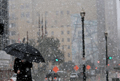
Newest 12Z guidance suggests some potential for light rain to mix with light snow tonight over the far northern counties of SE TX mainly from College Station to Lufkin. Afternoon dewpoints continue to run in the 20’s and 30’s across much of the northern ½ of SE TX and with the onset of rainfall this evening. Surface wet bulb temperatures are running in the mid 30’s over the northern sections of SE TX and once precipitation begins to fall the surface temperature will quickly cool toward the wet bulb temperature due to evaporative effects within the dry low level air mass. While surface temperatures will remain above freezing there is some potential for snow to mix with the rain. Profiles are very marginal for snow to reach the ground and most if not all will melt prior to reaching the surface, although would not be surprised to see a few flakes in the Livingston and Crockett areas late tonight. No accumulation is expected in SE TX although some light accumulation may occur over portions of N and NE TX.
Additionally, 12Z guidance has come in a little more aggressive with coastal surface low formation and rain chances/QPF for tonight into Wednesday AM. Will give the amounts a slight bump into the .25-.50 inch range for locations south of I-10 and possibly as much as .75 of an inch near the coast. Widespread coverage will require high rain chances overnight (60-70%) while amounts will on the low side.
Carla/Alicia/Jerry(In The Eye)/Michelle/Charley/Ivan/Dennis/Katrina/Rita/Wilma/Humberto/Ike/Harvey
Member: National Weather Association
Facebook.com/Weather Infinity
Twitter @WeatherInfinity
Newest 12Z guidance suggests some potential for light rain to mix with light snow tonight over the far northern counties of SE TX mainly from College Station to Lufkin. Afternoon dewpoints continue to run in the 20’s and 30’s across much of the northern ½ of SE TX and with the onset of rainfall this evening. Surface wet bulb temperatures are running in the mid 30’s over the northern sections of SE TX and once precipitation begins to fall the surface temperature will quickly cool toward the wet bulb temperature due to evaporative effects within the dry low level air mass. While surface temperatures will remain above freezing there is some potential for snow to mix with the rain. Profiles are very marginal for snow to reach the ground and most if not all will melt prior to reaching the surface, although would not be surprised to see a few flakes in the Livingston and Crockett areas late tonight. No accumulation is expected in SE TX although some light accumulation may occur over portions of N and NE TX.
Additionally, 12Z guidance has come in a little more aggressive with coastal surface low formation and rain chances/QPF for tonight into Wednesday AM. Will give the amounts a slight bump into the .25-.50 inch range for locations south of I-10 and possibly as much as .75 of an inch near the coast. Widespread coverage will require high rain chances overnight (60-70%) while amounts will on the low side.
how sad, so close but still so far, just drop down a bit more is it that hard?
tireman4 wrote:Just curious. I am going back in the Wayback Machine to December 2004, but did the snow that happened during that month...was it expected or come up suddenly? I do remember some of the models were forecasting it.......
We in s.e. Texas get a lot of unexpected circumstantial events. The models are useless with this type of thing. I've even seen big winter events occur that were not forecasted. As the cold and moisture settles in overnight, don't be surprised if you see something floating around now and again. The idea of a coastal low forming is intriquing as well.
tireman4 wrote:Just curious. I am going back in the Wayback Machine to December 2004, but did the snow that happened during that month...was it expected or come up suddenly? I do remember some of the models were forecasting it.......
About 16 days before Christmas of 2004, the GFS was predicting a Christmas Eve snow event along the TX coast. I mentioned it to a client and he bet me a steak dinner it wouldn't happen. I took the bet. Over the next 16 days, the GFS was quite consistent in forecasting the snow event. It wasn't a surprise when it happened.
I suppose I wished you say, Well, You never know", but as a meteorologist, I know you cannot. Sigh.
ABC13 mentioned the possibility of a few flakes from College Station over to Lake Livingston and to the northeast. You never know.
Now unless something truly magical happens, most of us will see just a cold rain. How about some sleet though? Is that at least possible? Not sure how the profiles have to be for sleet formation..
Surface low depicted near Vernon dropping SE. Upper low seems to be the ‘wintry’ producer. We'll see is the SE track holds and just misses to our N and E...
Carla/Alicia/Jerry(In The Eye)/Michelle/Charley/Ivan/Dennis/Katrina/Rita/Wilma/Humberto/Ike/Harvey
Member: National Weather Association
Facebook.com/Weather Infinity
Twitter @WeatherInfinity
wxman57 wrote:
Just finished decorating the Christmas tree. Now if I can just find my favorite Christmas song - "I'm dreaming of a hot july"...
I thought it was "dusty the sandman"?
Ok that was a good one. LOL
That it was tireman4. I'll give you that. OKC has a wintry mix at this hour and Tyler reported rain. The atmosphere should moisten up shortly across SE TX. I'm seeing returns off the Middle TX Coast as well.
Carla/Alicia/Jerry(In The Eye)/Michelle/Charley/Ivan/Dennis/Katrina/Rita/Wilma/Humberto/Ike/Harvey
Member: National Weather Association
Facebook.com/Weather Infinity
Twitter @WeatherInfinity
At least precip wise it appears that the yurpian <as Ed calls it> had a better idea about tonight from a week ago than did the GFS (good fer s...). It missed the thickness by enough to nix our 'fun', but at least it called for the moisture to arrive.
More proof that models are merely tools that need to be blended with 'gut feel' in order to make good forecasts.