
I need help with warnings
-
kevinrross
- Posts: 2
- Joined: Wed Jan 11, 2012 9:02 pm
- Contact:
Is there a place I can go see all of the tornado warnings issued by HGX on Monday? I need to see which counties were under a tornado warning and when. Thanks in advance for your help.
-
srainhoutx

- Site Admin

- Posts: 19699
- Joined: Tue Feb 02, 2010 2:32 pm
- Location: Maggie Valley, NC
- Contact:
Welcome to our Weather Forum. If you skim back through the thread link below, we did a fairly good job of getting all the the HGX Warnings out that day. While some have been missed due to the rapid nature of events, a team effort was put forth to provide those warnings in a timely manner...
http://forums.khou.com/viewtopic.php?f=2&t=1095
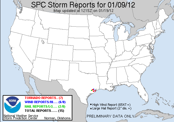
Surveys/Report Page from HGX:
http://www.srh.noaa.gov/hgx/?n=jan9_2012_storms
SPC Report Page as well:
http://forums.khou.com/viewtopic.php?f=2&t=1095
Surveys/Report Page from HGX:
http://www.srh.noaa.gov/hgx/?n=jan9_2012_storms
SPC Report Page as well:
Code: Select all
Tornado Reports (CSV) (Raw Tornado CSV)(?)
Time  Location County State Lat Lon Comments
1505  5 WNW MEADOWS  FORT BEND  TX 2968 9566 AN EF-1 TORNADO WITH WINDS OF 95 MPH TOUCHED DOWN NEAR THE INTERSECTION OF BISSONNET STREET AND GAINS ROAD IN MISSION BEND OF FORT BEND COUNTY. SEVERAL HOMES WERE DAMAG (HGX)
1855  4 SE DICKINSON  GALVESTON  TX 2941 9503 STORM SURVEY RATED THE DAMAGE FROM A TORNADO AS EF-0. LAW ENFORCEMENT WITNESSED TOUCH DOWN NEAR MALL OF THE MAINLAND IN TEXAS CITY. WINDOWS BLOWN OUT OF VEHICLES IN PAR (HGX)
1900  4 SE DICKINSON  GALVESTON  TX 2941 9503 LAW ENFORCEMENT WITNESSED TOUCH DOWN NEAR MALL OF THE MAINLAND IN TEXAS CITY. WINDOWS BLOWN OUT OF VEHICLES IN PARKING LOT. ROOF OF MALL DAMAGED. (HGX)
Hail Reports (CSV) (Raw Hail CSV)(?)
Time Size  Location County State Lat Lon Comments
1357 150 EAST BERNARD  WHARTON  TX 2953 9606 PING PONG SIZE HAIL IN EAST BERNARD RELAYED FROM HCFCD. (HGX)
1455 100 MISSION BEND  FORT BEND  TX 2969 9566 (HGX)
Wind Reports (CSV) (Raw Wind CSV)(?)
Time Speed  Location County State Lat Lon Comments
1505 UNK 4 WNW MEADOWS  FORT BEND  TX 2968 9566 ROOF DAMAGE TO HOMES IN THE MISSION BEND AREA. GARAGE DOORS BLOWN IN. POSSIBLE TORNADO. TIME ESTIMATED. (HGX)
1540 60 3 NE HILSHIRE VILLAGE  HARRIS  TX 2982 9545 60 MPH WIND GUST AT HCFCD AT HWY 290 AND LOOP 610. (HGX)
1730 UNK 3 SSE BONNEY  BRAZORIA  TX 2927 9544 ROOF BLOWN OFF. DEBRIS IN TREES. COUNTY ROAD 49. POSSIBLE TORNADO. (HGX)
1735 UNK 2 SE BONNEY  BRAZORIA  TX 2928 9544 TWO TRACTOR TRAILERS BLOWN OVER AROUND INTERSECTION OF 288 AND COUNTY ROAD 48. POSSIBLE TORNADO. (HGX)
1839 UNK SANTA FE  GALVESTON  TX 2938 9510 TREE DOWN CEMETERY ROAD. (HGX)
1855 UNK 4 SSE DICKINSON  GALVESTON  TX 2940 9505 TREES AND FENCES DOWN ALONG WESTWOOD LOOP IN LA MARQUE TEXAS. POSSIBLE TORNADO. (HGX)
Carla/Alicia/Jerry(In The Eye)/Michelle/Charley/Ivan/Dennis/Katrina/Rita/Wilma/Humberto/Ike/Harvey
Member: National Weather Association
Facebook.com/Weather Infinity
Twitter @WeatherInfinity
Member: National Weather Association
Facebook.com/Weather Infinity
Twitter @WeatherInfinity
-
kevinrross
- Posts: 2
- Joined: Wed Jan 11, 2012 9:02 pm
- Contact:
You guys do a fantastic job--I was just trying to avoid going back through 30 pages of posts. I was hoping there was one central repository. Thanks.
-
TexasBreeze
- Posts: 1017
- Joined: Sun Sep 26, 2010 4:46 pm
- Location: NW Houston, TX
- Contact:
http://www.srh.noaa.gov/productview.php?pil=HGXTORHGX
Each previous page (numbers at top) of page will give previous warnings issued.
Each previous page (numbers at top) of page will give previous warnings issued.