
Exactly what Ticka said.ticka1 wrote:just a few comments
first thank you Khou TV -gannett for this forun aling with srainhoutx, all the membes who posted updates and moderators - yall gave great info for another weather event.
thanks to jeff lindner -this guy is a machine during weather events always therebwith up to date infoan keeps us safe
and one last observation - I hate to think what would happen if we get a real tropical storm impacting this area this season - how bad will we flood.
May 2015 Record Setting May Rainfall Totals For Region
-
sambucol

- Posts: 1215
- Joined: Wed Feb 03, 2010 5:43 pm
- Location: Mont Belvieu
- Contact:
-
BlueJay
- Posts: 938
- Joined: Tue Mar 04, 2014 10:47 am
- Location: Alden Bridge-The Woodlands, Texas
- Contact:
sambucol wrote:Exactly what Ticka said.ticka1 wrote:just a few comments
first thank you Khou TV -gannett media for this forun aling with srainhoutx, all the membes who posted updates and moderators - yall gave great info for another weather event.
thanks to jeff lindner -this guy is a machine during weather events always therebwith up to date infoan keeps us safe
and one last observation - I hate to think what would happen if we get a real tropical storm impacting this area this season - how bad will we flood.
I agree too!
Ticka's point about our collective preparedness for a "real tropical storm impacting this area" at any time seems to be a legitmate concern. This weather event, even after weeks of warnings, has partially shut down Houston and other parts of Texas.
-
Ptarmigan

- Statistical Specialist

- Posts: 4431
- Joined: Wed Feb 03, 2010 7:20 pm
- Contact:
Quite a storm last night. Lot of lightning, thunder, and rain last night. Kept me up last night. It did destruction for Houston area and caused deaths. 
Last edited by Ptarmigan on Tue May 26, 2015 4:34 pm, edited 1 time in total.
-
Texaspirate11

- Posts: 1278
- Joined: Tue Dec 31, 2013 12:24 am
- Contact:
Jeff Lindner was a rockstar through this....
Was great working with so many in getting the word out. Night time storms are especially scary.
Was very happy to see so many who were aware....and even the Toyota Center cooperated. Our NWS rocked it also.
I think we're done with hurricane season right
Was great working with so many in getting the word out. Night time storms are especially scary.
Was very happy to see so many who were aware....and even the Toyota Center cooperated. Our NWS rocked it also.
I think we're done with hurricane season right
Just because you're disabled, you don't have to be a victim
Be Weather Aware & Prepared!
Barbara Jordan Winner in Media
Disability Integration Consultant
Be Weather Aware & Prepared!
Barbara Jordan Winner in Media
Disability Integration Consultant
-
redneckweather
- Posts: 1058
- Joined: Mon Feb 08, 2010 7:29 pm
- Location: Montgomery, Texas
- Contact:
About Tropical Systems....
Yes, they can drop a ton of rain but this was as bad if not worse than a lot of tropical systems we have seen in the past as far as inches of rain in a short period of time. Let's compare Hurricane Ike for reference.
http://www.srh.noaa.gov/hgx/?n=projects_ike08_rainfall
These are rainfall totals over a window of 24 hrs with a hurricane moving at a decent clip. The situation last night reminded me more of Allison....a decaying tropical system sitting over the top of you with no where to go...very intense rainfall totals over a short period of time.
-
srainhoutx

- Site Admin

- Posts: 19699
- Joined: Tue Feb 02, 2010 2:32 pm
- Location: Maggie Valley, NC
- Contact:
It looks like isolated showers and storms with daytime heating will be the theme for the remainder of the work week. Both the GFS and Euro are suggesting a stalling boundary draped across Central and SE Texas this weekend which tends to favor increasing storm chances Saturday into Sunday. That takes us into the last days of May which will likely see a lot of monthly rainfall records fall across a lot of the Lone Star State for the month of May.
Carla/Alicia/Jerry(In The Eye)/Michelle/Charley/Ivan/Dennis/Katrina/Rita/Wilma/Humberto/Ike/Harvey
Member: National Weather Association
Facebook.com/Weather Infinity
Twitter @WeatherInfinity
Member: National Weather Association
Facebook.com/Weather Infinity
Twitter @WeatherInfinity
-
unome
- Posts: 3062
- Joined: Fri Feb 12, 2010 6:11 pm
http://www.entergynewsroom.com/blog/lew ... r-updates/
Published: 05/26/2015
Update - 5/26/15 10:30 am
Significant storms moved through the area of the Lewis Creek Reservoir yesterday for several hours starting at 7:30 p.m.
The company's mitigation efforts successfully maintained the dam's integrity and no breach has occurred, but inspections have revealed a new area of some soil movement. A new slide was not unexpected and will be covered today with protective covering.
Our work today will concentrate on addressing the new area of soil movement and repositioning the protective covering that may have shifted. In addition, we will make further repairs on identified slides and continue implementing and refining a testing and long-term remediation.
Part of our longer-term strategy to protect against future soil slides that may occur includes pre-positioning materials, such as covering and limestone, in order to mitigate a new slide quickly should it develop.
Our customer information center has closed. Regarding the financial assistance program for residents near the Lewis Creek Reservoir who were directly affected by Montgomery County's determination that mandatory evacuations were appropriate, the company will contact those customers by letter and handle all applications via mail.
In addition, we will monitor the water level of the reservoir, which could rise for several hours following due to last night’s rainfall, and adjust as needed.
-
nuby3
- Posts: 387
- Joined: Mon Feb 22, 2010 10:25 pm
- Location: THE WOODLANDS PARKWAY and FM 2978
- Contact:
the storms in north central Texas look headed this way? radar estimate of 2-3 inches accumulating in the last hour up there. 6-8 inch totals
-
unome
- Posts: 3062
- Joined: Fri Feb 12, 2010 6:11 pm
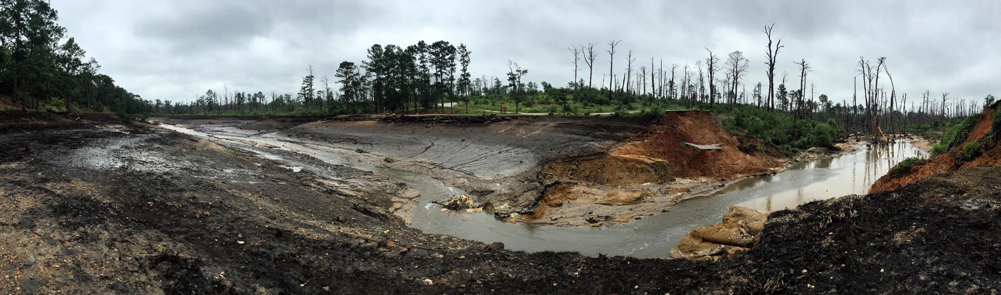
From TX Parks & Wildlife - a short video "Looking at what used to be lake at #Bastrop State Park"
https://vine.co/v/ebBWvdQXZeV
and a huge panoramic pic they posted on Twitter, "Panoramic view of where lake used to be at #Bastrop State Park before dam breach"
https://pbs.twimg.com/media/CF8S7rEW0AAz-BR.jpg:large
https://vine.co/v/ebBWvdQXZeV
and a huge panoramic pic they posted on Twitter, "Panoramic view of where lake used to be at #Bastrop State Park before dam breach"
https://pbs.twimg.com/media/CF8S7rEW0AAz-BR.jpg:large
-
nuby3
- Posts: 387
- Joined: Mon Feb 22, 2010 10:25 pm
- Location: THE WOODLANDS PARKWAY and FM 2978
- Contact:
watching cell mergers take place west of dallas and fort worth, they are getting blasted up there. looks headed south and east .
there is now a spot there with a radar estimated 4 inches of actual accumulation in the last hour
there is now a spot there with a radar estimated 4 inches of actual accumulation in the last hour
-
Ptarmigan
- Statistical Specialist
- Posts: 4431
- Joined: Wed Feb 03, 2010 7:20 pm
- Contact:
Not good.nuby3 wrote:the storms in north central Texas look headed this way? radar estimate of 2-3 inches accumulating in the last hour up there. 6-8 inch totals
-
Paul Robison
All right, what time are these storms going to arrive in the Houston metro and add to our miseries, Ptarmigan?Ptarmigan wrote:Not good.nuby3 wrote:the storms in north central Texas look headed this way? radar estimate of 2-3 inches accumulating in the last hour up there. 6-8 inch totals
-
addseo1115
- Posts: 6
- Joined: Sat Apr 25, 2015 2:37 am
- Contact:
that is good weather forecast.
-
djjordan

- Posts: 929
- Joined: Fri Feb 05, 2010 7:19 pm
- Location: Montgomery, Texas
- Contact:
FLOOD ADVISORY
NATIONAL WEATHER SERVICE HOUSTON/GALVESTON TX
244 AM CDT WED MAY 27 2015
TXC041-225-313-271045-
/O.NEW.KHGX.FA.Y.0116.150527T0744Z-150527T1045Z/
/00000.N.ER.000000T0000Z.000000T0000Z.000000T0000Z.OO/
HOUSTON TX-MADISON TX-BRAZOS TX-
244 AM CDT WED MAY 27 2015
THE NATIONAL WEATHER SERVICE IN LEAGUE CITY HAS ISSUED A
* URBAN AND SMALL STREAM FLOOD ADVISORY FOR...
HOUSTON COUNTY IN SOUTHEASTERN TEXAS...
MADISON COUNTY IN SOUTHEASTERN TEXAS...
NORTHERN BRAZOS COUNTY IN SOUTHEASTERN TEXAS...
* UNTIL 545 AM CDT
* AT 241 AM CDT...DOPPLER RADAR INDICATED HEAVY RAIN DUE TO
THUNDERSTORMS. THIS WILL CAUSE URBAN AND SMALL STREAM FLOODING IN
THE ADVISORY AREA. RAINFALL OF 1 TO 2 INCHES IS POSSIBLE WITH
THESE STORMS.
* SOME LOCATIONS THAT WILL EXPERIENCE FLOODING INCLUDE...
NORTHWESTERN BRYAN...CROCKETT...MADISONVILLE...AUSTONIO...
GRAPELAND...LOVELADY...KURTEN...KENNARD...LATEXO...WIXON VALLEY...
MIDWAY...NORMANGEE...NORTH ZULCH AND WECHES.
PRECAUTIONARY/PREPAREDNESS ACTIONS...
MOST FLOOD DEATHS OCCUR IN AUTOMOBILES. BE ESPECIALLY CAREFUL AT
NIGHT. NEVER DRIVE YOUR VEHICLE INTO AREAS WHERE THE WATER COVERS
THE ROADWAY. FLOOD WATERS ARE USUALLY DEEPER THAN THEY APPEAR. JUST
ONE FOOT OF FLOWING WATER IS POWERFUL ENOUGH TO SWEEP VEHICLES OFF
THE ROAD. WHEN ENCOUNTERING FLOODED ROADS MAKE THE SMART
CHOICE...TURN AROUND...DONT DROWN.
EXCESSIVE RUNOFF FROM HEAVY RAINFALL WILL CAUSE FLOODING OF SMALL
CREEKS AND STREAMS...AS WELL AS FARM AND COUNTRY ROADS. DO NOT
ATTEMPT TO TRAVEL ACROSS FLOODED ROADS. FIND ALTERNATE ROUTES.
TO REPORT FLOODING...HAVE THE NEAREST LAW ENFORCEMENT AGENCY RELAY
YOUR REPORT TO THE NATIONAL WEATHER SERVICE FORECAST OFFICE.
~~~When Thunder Roars Go Indoors~~~
~~~Turn Around Don't Drown~~~
~~~Run From The Water, Hide From The Wind~~~
~~~Turn Around Don't Drown~~~
~~~Run From The Water, Hide From The Wind~~~
-
djjordan
- Posts: 929
- Joined: Fri Feb 05, 2010 7:19 pm
- Location: Montgomery, Texas
- Contact:
BULLETIN - IMMEDIATE BROADCAST REQUESTED
SEVERE THUNDERSTORM WARNING
NATIONAL WEATHER SERVICE HOUSTON/GALVESTON TX
255 AM CDT WED MAY 27 2015
THE NATIONAL WEATHER SERVICE IN LEAGUE CITY HAS ISSUED A
* SEVERE THUNDERSTORM WARNING FOR...
CENTRAL HOUSTON COUNTY IN SOUTHEASTERN TEXAS...
NORTHWESTERN TRINITY COUNTY IN SOUTHEASTERN TEXAS...
* UNTIL 330 AM CDT
* AT 254 AM CDT...DOPPLER RADAR INDICATED A SEVERE THUNDERSTORM
CAPABLE OF PRODUCING DAMAGING WINDS IN EXCESS OF 60 MPH. THIS STORM
WAS LOCATED 8 MILES SOUTH OF KENNARD...OR 14 MILES WEST OF APPLE
SPRINGS...AND MOVING NORTHEAST AT 30 MPH.
* LOCATIONS IMPACTED INCLUDE...
CROCKETT...AUSTONIO...LOVELADY...KENNARD...PENNINGTON AND
CENTRALIA.
PRECAUTIONARY/PREPAREDNESS ACTIONS...
SEVERE THUNDERSTORMS PRODUCE DAMAGING WINDS...DESTRUCTIVE HAIL...
DEADLY LIGHTNING AND VERY HEAVY RAIN. FOR YOUR PROTECTION...MOVE TO
AN INTERIOR ROOM ON THE LOWEST FLOOR OF YOUR HOME OR BUSINESS. HEAVY
RAINS FLOOD ROADS QUICKLY SO DO NOT DRIVE INTO AREAS WHERE WATER
COVERS THE ROAD.
TORRENTIAL RAINFALL IS ALSO OCCURRING WITH THIS STORM...AND MAY LEAD
TO FLASH FLOODING. DO NOT DRIVE YOUR VEHICLE THROUGH FLOODED
ROADWAYS.
~~~When Thunder Roars Go Indoors~~~
~~~Turn Around Don't Drown~~~
~~~Run From The Water, Hide From The Wind~~~
~~~Turn Around Don't Drown~~~
~~~Run From The Water, Hide From The Wind~~~
-
djjordan
- Posts: 929
- Joined: Fri Feb 05, 2010 7:19 pm
- Location: Montgomery, Texas
- Contact:
BULLETIN - IMMEDIATE BROADCAST REQUESTED
SEVERE THUNDERSTORM WARNING
NATIONAL WEATHER SERVICE HOUSTON/GALVESTON TX
301 AM CDT WED MAY 27 2015
THE NATIONAL WEATHER SERVICE IN LEAGUE CITY HAS ISSUED A
* SEVERE THUNDERSTORM WARNING FOR...
NORTH CENTRAL POLK COUNTY IN SOUTHEASTERN TEXAS...
NORTHEASTERN TRINITY COUNTY IN SOUTHEASTERN TEXAS...
* UNTIL 330 AM CDT
* AT 301 AM CDT...DOPPLER RADAR INDICATED A SEVERE THUNDERSTORM
CAPABLE OF PRODUCING DAMAGING WINDS IN EXCESS OF 60 MPH. THIS STORM
WAS LOCATED NEAR APPLE SPRINGS...AND MOVING NORTHEAST AT 30 MPH.
* LOCATIONS IMPACTED INCLUDE...
APPLE SPRINGS.
PRECAUTIONARY/PREPAREDNESS ACTIONS...
SEVERE THUNDERSTORMS PRODUCE DAMAGING WINDS...DESTRUCTIVE HAIL...
DEADLY LIGHTNING AND VERY HEAVY RAIN. FOR YOUR PROTECTION...MOVE TO
AN INTERIOR ROOM ON THE LOWEST FLOOR OF YOUR HOME OR BUSINESS. HEAVY
RAINS FLOOD ROADS QUICKLY SO DO NOT DRIVE INTO AREAS WHERE WATER
COVERS THE ROAD.
TORRENTIAL RAINFALL IS ALSO OCCURRING WITH THIS STORM...AND MAY LEAD
TO FLASH FLOODING. DO NOT DRIVE YOUR VEHICLE THROUGH FLOODED
ROADWAYS.
~~~When Thunder Roars Go Indoors~~~
~~~Turn Around Don't Drown~~~
~~~Run From The Water, Hide From The Wind~~~
~~~Turn Around Don't Drown~~~
~~~Run From The Water, Hide From The Wind~~~
-
djjordan
- Posts: 929
- Joined: Fri Feb 05, 2010 7:19 pm
- Location: Montgomery, Texas
- Contact:
Watching radar this morning noticing the inflow interacting with the complex of storms and slowing them down across the Northern portions of SE Texas currently. Gonna keep a close eye this morning for additional flooding concerns. We'll have to see how this pans out.
~~~When Thunder Roars Go Indoors~~~
~~~Turn Around Don't Drown~~~
~~~Run From The Water, Hide From The Wind~~~
~~~Turn Around Don't Drown~~~
~~~Run From The Water, Hide From The Wind~~~
-
djjordan
- Posts: 929
- Joined: Fri Feb 05, 2010 7:19 pm
- Location: Montgomery, Texas
- Contact:
SPECIAL WEATHER STATEMENT
NATIONAL WEATHER SERVICE HOUSTON/GALVESTON TX
331 AM CDT WED MAY 27 2015
TXZ164-179-270915-
TRINITY TX-POLK TX-
331 AM CDT WED MAY 27 2015
...SIGNIFICANT WEATHER ADVISORY FOR NORTH CENTRAL POLK AND EAST
CENTRAL TRINITY COUNTIES UNTIL 415 AM CDT...
AT 330 AM CDT...DOPPLER RADAR WAS TRACKING A STRONG THUNDERSTORM 7
MILES NORTHWEST OF CORRIGAN...OR 10 MILES SOUTH OF APPLE SPRINGS...
MOVING NORTHEAST AT 30 MPH.
WIND GUSTS UP TO 50 MPH WILL BE POSSIBLE WITH THIS STORM.
LOCATIONS IMPACTED INCLUDE...
CORRIGAN.
PRECAUTIONARY/PREPAREDNESS ACTIONS...
TORRENTIAL RAINFALL IS ALSO OCCURRING WITH THIS STORM...AND MAY LEAD
TO FLASH FLOODING. DO NOT DRIVE YOUR VEHICLE THROUGH FLOODED
ROADWAYS.
FREQUENT CLOUD TO GROUND LIGHTNING IS OCCURRING WITH THIS STORM.
LIGHTNING CAN STRIKE 15 MILES AWAY FROM A THUNDERSTORM. SEEK A SAFE
SHELTER INSIDE A BUILDING OR VEHICLE.
THIS STORM MAY INTENSIFY...SO BE CERTAIN TO MONITOR LOCAL RADIO AND
TV STATIONS...AS WELL AS LOCAL CABLE TV OUTLETS...FOR ADDITIONAL
INFORMATION AND POSSIBLE WARNINGS FROM THE NATIONAL WEATHER SERVICE.
~~~When Thunder Roars Go Indoors~~~
~~~Turn Around Don't Drown~~~
~~~Run From The Water, Hide From The Wind~~~
~~~Turn Around Don't Drown~~~
~~~Run From The Water, Hide From The Wind~~~
-
djjordan
- Posts: 929
- Joined: Fri Feb 05, 2010 7:19 pm
- Location: Montgomery, Texas
- Contact:
SPECIAL WEATHER STATEMENT
NATIONAL WEATHER SERVICE HOUSTON/GALVESTON TX
333 AM CDT WED MAY 27 2015
TXZ164-178-179-270900-
TRINITY TX-SAN JACINTO TX-POLK TX-
333 AM CDT WED MAY 27 2015
...SIGNIFICANT WEATHER ADVISORY FOR NORTHWESTERN POLK...SOUTHERN
TRINITY AND NORTHERN SAN JACINTO COUNTIES UNTIL 400 AM CDT...
AT 333 AM CDT...DOPPLER RADAR WAS TRACKING A STRONG THUNDERSTORM OVER
SEBASTOPOL...OR 21 MILES NORTHWEST OF LIVINGSTON...MOVING NORTHEAST
AT 30 MPH.
WIND GUSTS UP TO 50 MPH WILL BE POSSIBLE WITH THIS STORM.
LOCATIONS IMPACTED INCLUDE...
GROVETON AND SEBASTOPOL.
PRECAUTIONARY/PREPAREDNESS ACTIONS...
TORRENTIAL RAINFALL IS ALSO OCCURRING WITH THIS STORM...AND MAY LEAD
TO FLASH FLOODING. DO NOT DRIVE YOUR VEHICLE THROUGH FLOODED
ROADWAYS.
FREQUENT CLOUD TO GROUND LIGHTNING IS OCCURRING WITH THIS STORM.
LIGHTNING CAN STRIKE 15 MILES AWAY FROM A THUNDERSTORM. SEEK A SAFE
SHELTER INSIDE A BUILDING OR VEHICLE.
THIS STORM MAY INTENSIFY...SO BE CERTAIN TO MONITOR LOCAL RADIO AND
TV STATIONS...AS WELL AS LOCAL CABLE TV OUTLETS...FOR ADDITIONAL
INFORMATION AND POSSIBLE WARNINGS FROM THE NATIONAL WEATHER SERVICE.
~~~When Thunder Roars Go Indoors~~~
~~~Turn Around Don't Drown~~~
~~~Run From The Water, Hide From The Wind~~~
~~~Turn Around Don't Drown~~~
~~~Run From The Water, Hide From The Wind~~~
-
djjordan
- Posts: 929
- Joined: Fri Feb 05, 2010 7:19 pm
- Location: Montgomery, Texas
- Contact:
THE NATIONAL WEATHER SERVICE IN LEAGUE CITY HAS ISSUED A
* FLOOD ADVISORY FOR...
SOUTHEASTERN MADISON COUNTY IN SOUTHEASTERN TEXAS...
CENTRAL WALKER COUNTY IN SOUTHEASTERN TEXAS...
SOUTHEASTERN BRAZOS COUNTY IN SOUTHEASTERN TEXAS...
NORTHWESTERN MONTGOMERY COUNTY IN SOUTHEASTERN TEXAS...
NORTHERN GRIMES COUNTY IN SOUTHEASTERN TEXAS...
* UNTIL 545 AM CDT
* AT 348 AM CDT...DOPPLER RADAR INDICATED HEAVY RAIN DUE TO
THUNDERSTORMS. THIS WILL CAUSE MINOR FLOODING IN THE ADVISORY
AREA. RAINFALL UP TO 2.5 INCHES OF RAIN HAVE FALLEN IN THE
STRONGER STORMS.
* SOME LOCATIONS THAT WILL EXPERIENCE FLOODING INCLUDE...
COLLEGE STATION...BRYAN...NORTHWESTERN HUNTSVILLE...RIVERSIDE...
BEDIAS...WIXON VALLEY...MILLICAN...KYLE FIELD...IOLA...WELLBORN...
CRABBS PRAIRIE...CARLOS AND ROANS PRAIRIE.
PRECAUTIONARY/PREPAREDNESS ACTIONS...
DO NOT DRIVE YOUR VEHICLE INTO AREAS WHERE THE WATER COVERS THE
ROADWAY. THE WATER DEPTH MAY BE TOO GREAT TO ALLOW YOUR CAR TO CROSS
SAFELY. MOVE TO HIGHER GROUND.
TO REPORT FLOODING...HAVE THE NEAREST LAW ENFORCEMENT AGENCY RELAY
YOUR REPORT TO THE NATIONAL WEATHER SERVICE FORECAST OFFICE.
A FLOOD ADVISORY MEANS RIVER OR STREAM FLOWS ARE ELEVATED...OR
PONDING OF WATER IN URBAN OR OTHER AREAS IS OCCURRING OR IS IMMINENT.
DO NOT ATTEMPT TO TRAVEL ACROSS FLOODED ROADS. FIND ALTERNATE ROUTES.
IT TAKES ONLY A FEW INCHES OF SWIFTLY FLOWING WATER TO CARRY VEHICLES
AWAY.
~~~When Thunder Roars Go Indoors~~~
~~~Turn Around Don't Drown~~~
~~~Run From The Water, Hide From The Wind~~~
~~~Turn Around Don't Drown~~~
~~~Run From The Water, Hide From The Wind~~~