May 2016: Shower/Storm Chances To End May

General Weather Discussions and Analysis
User avatar
DoctorMu
Posts: 6494
Joined: Sun Jun 28, 2015 11:58 am
Location: College Station
Contact:

srainhoutx wrote:Those of you in Richmond, the Brazos River may crest Monday at levels equal to the October 1994 Regional Flood Event.

This is the most rain I've seen for a storm system since the Oct 1994 event. 18+ inches in 36 hours then. I literally had to kick down the fence to let water out of the backyard into the side and then the street. Water still seeped into the home over the slab through the weepholes. What a mess.
User avatar
srainhoutx
Site Admin
Site Admin
Posts: 19673
Joined: Tue Feb 02, 2010 2:32 pm
Location: Maggie Valley, NC
Contact:

Severe Thunderstorm Watch has been hoisted.
Carla/Alicia/Jerry(In The Eye)/Michelle/Charley/Ivan/Dennis/Katrina/Rita/Wilma/Humberto/Ike/Harvey

Member: National Weather Association
Facebook.com/Weather Infinity
Twitter @WeatherInfinity
User avatar
DoctorMu
Posts: 6494
Joined: Sun Jun 28, 2015 11:58 am
Location: College Station
Contact:

tireman4 wrote:If trends are such, I would say ( I am not Srain or Andrew) yes....eventually.
Cypress and Katy are about to be slammed first.
Last edited by DoctorMu on Fri May 27, 2016 3:00 pm, edited 1 time in total.
User avatar
Texaspirate11
Posts: 1278
Joined: Tue Dec 31, 2013 12:24 am
Contact:

DoctorMu wrote:
srainhoutx wrote:Those of you in Richmond, the Brazos River may crest Monday at levels equal to the October 1994 Regional Flood Event.

This is the most rain I've seen for a storm system since the Oct 1994 event. 18+ inches in 36 hours then. I literally had to kick down the fence to let water out of the backyard into the side and then the street. Water still seeped into the home over the slab through the weepholes. What a mess.
Just think Hurricane Season is in 5 days.....
Just because you're disabled, you don't have to be a victim
Be Weather Aware & Prepared!
Barbara Jordan Winner in Media
Disability Integration Consultant
unome
Posts: 3059
Joined: Fri Feb 12, 2010 6:11 pm

this was just released, but I noticed the date is yesterday ?

http://mesonet.agron.iastate.edu/lsr/#H ... 62308/0100

3 Miles SSE Cut and Shoot

Time: 2016-05-26T23:08:00Z UTC
Event: TSTM WND DMG
Source: PUBLIC
Remark: 10 TREES DOWN INCLUDING 100 YEAR OLD OAK AT 25 ACRE RESIDENCE.
BlueJay
Posts: 938
Joined: Tue Mar 04, 2014 10:47 am
Location: Alden Bridge-The Woodlands, Texas
Contact:

I imagine there are many folks rearranging their Memorial Day weekend plans :?
User avatar
srainhoutx
Site Admin
Site Admin
Posts: 19673
Joined: Tue Feb 02, 2010 2:32 pm
Location: Maggie Valley, NC
Contact:

3:00 PM Update from Jeff:

Band of slow moving heavy rainfall impacting northern Harris County.

Rainfall last 1-2 inches of 1-3 inches over Spring Creek with storm totals of 9-11 inches. Band of heavy rainfall is sagging very slowly southward into more of Harris County, but into areas that have not seen overly heavy rainfall thus far with this event.

Main threat going forward will be an additional 1-3 inches of rainfall which will lead to new rises on creeks across the northern part of Harris County and likely street flooding across portions of Houston for the evening rush hour. Additionally, many roads in the northern part of the county are closed from overwhelmed roadside ditches and flooding from creeks and tributaries.

Flooding along Spring Creek is nearing levels recorded during the 2016 Tax Day flood event.

Radar Estimated Storm Totals (Match well with gage reports):
05272016 Jeff 3 unnamed.png
[/i]
Carla/Alicia/Jerry(In The Eye)/Michelle/Charley/Ivan/Dennis/Katrina/Rita/Wilma/Humberto/Ike/Harvey

Member: National Weather Association
Facebook.com/Weather Infinity
Twitter @WeatherInfinity
User avatar
srainhoutx
Site Admin
Site Admin
Posts: 19673
Joined: Tue Feb 02, 2010 2:32 pm
Location: Maggie Valley, NC
Contact:

SPC issues Slight Risk for Severe Storms. Damaging winds is the primary threat.
Attachments
05272016 day1otlk_2000.gif
Carla/Alicia/Jerry(In The Eye)/Michelle/Charley/Ivan/Dennis/Katrina/Rita/Wilma/Humberto/Ike/Harvey

Member: National Weather Association
Facebook.com/Weather Infinity
Twitter @WeatherInfinity
User avatar
srainhoutx
Site Admin
Site Admin
Posts: 19673
Joined: Tue Feb 02, 2010 2:32 pm
Location: Maggie Valley, NC
Contact:

Update from Jeff:

Heavy rainfall of over 4.0 inches in the last 3 hours in pushing Spring Creek from the headwaters to below FM 2978 to near or over record levels. Levels are surpassing those recorded in October 1994.

Storm total rainfall is averaging 10-12 inches over the Spring Creek watershed

House flooding will be possible along the creek on both the Montgomery and Harris County sides similar to that experienced in October 1994.
Carla/Alicia/Jerry(In The Eye)/Michelle/Charley/Ivan/Dennis/Katrina/Rita/Wilma/Humberto/Ike/Harvey

Member: National Weather Association
Facebook.com/Weather Infinity
Twitter @WeatherInfinity
unome
Posts: 3059
Joined: Fri Feb 12, 2010 6:11 pm

Area Forecast Discussion
National Weather Service Houston/Galveston TX
317 PM CDT FRI MAY 27 2016

.DISCUSSION...
The latest water vapor imagery shows the upper level low over
CO/KS border with its trough axis stretching into central Texas.
Thunderstorm activity has formed north of a strong outflow
boundary which has become more oriented on the boundary and
training along it. Overall motion of the line of storms is to the
SE but individual storms are moving ENE/NE. This has allowed for
some hourly rain rates near 2-3 inches an hour over some of the
same areas that flooded last night and yesterday. Storms should
track into Houston over the next couple of hours before moving
east. The HRRR 18z run seems to have a decent handle on the
current evolution and pushes the convection towards the coast.
This really depends on whether storms become more organized and
cold outflow can push the boundary south. HRRR seems to fast with
this motion compared to current trends. Could see scattered storms
continue through the evening and slowly transition east out of SE
Texas by midnight.

Upper level ridging builds over SE Texas this weekend and into
early next week. Precipitable water values drop to under 1.5
inches so may only see an isolated storm with day time heating
each of Saturday and Sunday. Moisture increase back again late
Monday into Tuesday which will support higher rain chances as the
ridge breaks down. For the middle of next week the upper level
pattern becomes more amplified with an upper level trough forming
over the plains. A frontal boundary works south as well which will
be a focus for more thunderstorm activity. There may also be a
couple of week short wave troughs that move over the area to help
support thunderstorm activity. The 3 to 4 day break from heavy
rainfall should allow for much needed runoff and receding of
flooding. We will likely need to monitor the extended forecast
next week for another heavy rainfall threat.


&&

.MARINE...
Very strong onshore winds persisting across the coastal waters today
and expecting this pattern to linger through the rest of the aftn on
into the early evening hours as the associated line of storms across
SE TX moves offshore. These storms are forecast to move off to the E
and SE this evening with light/brief offshore winds in its wake.

However onshore winds will be returning to the marine waters
tomorrow- ow and will be prevailing the rest of this holiday
weekend. With the weather less active, winds and seas should also
be lower.

The persistent fetch from Gulf combined with the strong onshore flow
have helped raise tide levels to near 3.3 feet above MLLW this aftn.
With the winds decreasing tonight, tides should follow suit as well.
41

&&

.PRELIMINARY POINT TEMPS/POPS...
College Station (CLL) 71 88 73 86 71 / 30 30 10 20 20
Houston (IAH) 74 89 73 88 71 / 40 30 10 20 10
Galveston (GLS) 78 85 78 84 77 / 40 20 10 20 10

&&

.HGX WATCHES/WARNINGS/ADVISORIES...
TX...Flash Flood Watch until 10 PM CDT this evening FOR THE FOLLOWING
ZONES: Austin...Brazos...Burleson...Chambers...Colorado...
Fort Bend...Grimes...Harris...Houston...Liberty...Madison...
Montgomery...Polk...San Jacinto...Trinity...Walker...
Waller...Washington...Wharton.

High Rip Current Risk until 10 PM CDT this evening FOR THE
FOLLOWING ZONES: Brazoria...Chambers...Galveston...
Matagorda.

GM...Small Craft Advisory until 6 PM CDT this evening FOR THE
FOLLOWING ZONES: Coastal waters from Freeport to the
Matagorda Ship Channel out 20 NM...Coastal waters from High
Island to Freeport out 20 NM...Galveston Bay...Matagorda
Bay.

SMALL CRAFT SHOULD EXERCISE CAUTION from 6 PM this evening to 1
AM CDT Saturday FOR THE FOLLOWING ZONES: Galveston Bay...
Matagorda Bay.

SMALL CRAFT SHOULD EXERCISE CAUTION from 6 PM CDT this evening
through Saturday morning FOR THE FOLLOWING ZONES: Coastal
waters from Freeport to the Matagorda Ship Channel out 20
NM...Coastal waters from High Island to Freeport out 20 NM.

Small Craft Advisory until 10 PM CDT this evening FOR THE
FOLLOWING ZONES: Waters from Freeport to the Matagorda Ship
Channel from 20 to 60 NM...Waters from High Island to
Freeport from 20 to 60 NM.

SMALL CRAFT SHOULD EXERCISE CAUTION from 10 PM CDT this evening
through Saturday morning FOR THE FOLLOWING ZONES: Waters
from Freeport to the Matagorda Ship Channel from 20 to 60
NM...Waters from High Island to Freeport from 20 to 60 NM.

&&

$$

Discussion...39
Aviation/Marine...41
Last edited by unome on Fri May 27, 2016 3:55 pm, edited 1 time in total.
User avatar
djjordan
Posts: 928
Joined: Fri Feb 05, 2010 7:19 pm
Location: Montgomery, Texas
Contact:

BULLETIN - EAS ACTIVATION REQUESTED
FLASH FLOOD WARNING
NATIONAL WEATHER SERVICE HOUSTON/GALVESTON TX
332 PM CDT FRI MAY 27 2016

THE NATIONAL WEATHER SERVICE IN LEAGUE CITY HAS ISSUED A

* FLASH FLOOD WARNING FOR...
NORTHERN COLORADO COUNTY IN SOUTHEASTERN TEXAS...
SOUTHWESTERN WALLER COUNTY IN SOUTHEASTERN TEXAS...
AUSTIN COUNTY IN SOUTHEASTERN TEXAS...

* UNTIL 530 PM CDT

* AT 330 PM CDT...DOPPLER RADAR INDICATED A LINE OF SLOW MOVING
THUNDERSTORMS PRODUCING HEAVY RAIN ACROSS THE WARNED AREA. FLASH
FLOODING IS EXPECTED TO BEGIN SHORTLY. HOURLY RAINFALL RATES ARE
BETWEEN 1 AND 3 INCHES.

* SOME LOCATIONS THAT WILL EXPERIENCE FLOODING INCLUDE...
SEALY...BELLVILLE...COLUMBUS...WEIMAR...SAN FELIPE...INDUSTRY...
FRELSBURG...CAT SPRING AND NEW ULM.

PRECAUTIONARY/PREPAREDNESS ACTIONS...

TURN AROUND...DON`T DROWN WHEN ENCOUNTERING FLOODED ROADS. MOST FLOOD
DEATHS OCCUR IN VEHICLES.

EXCESSIVE RUNOFF FROM HEAVY RAINFALL WILL CAUSE FLOODING OF SMALL
CREEKS AND STREAMS...COUNTRY ROADS...FARMLAND...AND OTHER LOW LYING
SPOTS.
~~~When Thunder Roars Go Indoors~~~
~~~Turn Around Don't Drown~~~
~~~Run From The Water, Hide From The Wind~~~
unome
Posts: 3059
Joined: Fri Feb 12, 2010 6:11 pm

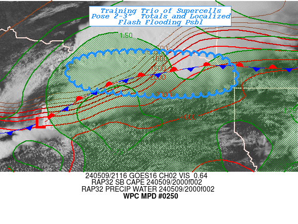
Image

MESOSCALE PRECIPITATION DISCUSSION 0250
NWS WEATHER PREDICTION CENTER COLLEGE PARK MD
428 PM EDT FRI MAY 27 2016

AREAS AFFECTED...SOUTHEAST TX...WESTERN/CENTRAL LA

CONCERNING...HEAVY RAINFALL...FLASH FLOODING LIKELY

VALID 272025Z - 280025Z

SUMMARY...SLOW-MOVING AND HEAVY SHOWERS AND THUNDERSTORMS WILL
SETTLE GRADUALLY SOUTHEAST THROUGH THE LATE-AFTERNOON AND EVENING
HOURS TOWARD THE WESTERN GULF COAST. FLASH FLOODING IS LIKELY AS
THIS ACTIVITY MOVES THROUGH.

DISCUSSION...AN ELONGATED AND VERY COLD-TOPPED MCS IS GRADUALLY
SETTLING SOUTHEAST AND WILL BE REACHING THE MIDDLE AND UPPER TX
COAST OVER THE NEXT COUPLE OF HOURS WHILE ALSO EXTENDING EAST
ACROSS WESTERN AND CENTRAL LA.

RAINFALL RATES WITHIN THIS STRONG BAND OF CONVECTION HAVE ALREADY
BEEN EXCEEDING 2 INCHES/HR...AND THESE RATES ARE EXPECTED TO
CONTINUE OVER THE NEXT FEW HOURS AS AREA VWPS SHOW A DEEP FEED OF
VERY MOIST AND UNSTABLE AIR LIFTING NORTH FROM THE WESTERN GULF OF
MEXICO AND FOCUSING ESPECIALLY ACROSS THE IMMEDIATE SOUTHEAST TX
COASTAL PLAIN.

RAP ANALYSES ARE SHOWING MLCAPE VALUES OF 2000 TO 3000 J/KG ALONG
THE UPPER TX COAST...AND EVEN GREATER VALUES FARTHER SOUTHWEST
BETWEEN HOUSTON AND VICTORIA. INSTABILITY PARAMETERS ARE A BIT
WEAKER ACROSS CENTRAL AND WESTERN LA AND CLOSER TO 1500 J/KG.
GPS-DERIVED PWATS ARE NEAR 2 INCHES ACROSS THE SOUTHEAST TX
COASTAL PLAIN WITH SOMEWHAT LOWER NUMBERS OVER LA. THUS
OVERALL...A HIGHLY FAVORABLE THERMODYNAMIC ENVIRONMENT FOR
SUSTAINABLE CONVECTION AND VERY HIGH RAINFALL RATES.

THE LAST FEW HRRR RUNS HAVE BEEN APPEARING A TAD SLOW TO ADVANCE
THE CONVECTION SOUTHEAST TOWARD THE GULF COAST...WHICH APPEARS TO
BE RELATED TO A MISHANDLING OF THE STRENGTH OF THE MCS COLD POOL.
NEVERTHELESS...THE GUIDANCE HAS BEEN INSISTING OF VERY HEAVY
RAINFALL TOTALS....AND ADDITIONAL RAINFALL AMOUNTS THROUGH 00Z ARE
EXPECTED TO BE ON THE ORDER OF 3 TO 6 INCHES. SOME OF THE AREAS
WITHIN THE THE MPD THREAT AREA HAVE SEEN HEAVY RAINS
RECENTLY...AND SO THESE ADDITIONAL RAINS ARE LIKELY TO CAUSE FLASH
FLOODING...AND THE MORE URBANIZED AREAS INVOLVING THE HOUSTON
METROPOLITAN AREA SHOULD BE ON ALERT FOR LOCALLY SIGNIFICANT URBAN
FLOODING CONCERNS. WILL CONTINUE TO MONITOR.

ORRISON

ATTN...WFO...CRP...EWX...HGX...JAN...LCH...SHV...

ATTN...RFC...LMRFC...WGRFC...
unome
Posts: 3059
Joined: Fri Feb 12, 2010 6:11 pm

http://www.harriscountyfws.org/GageDetail/Index/1220

Little Cypress Creek at Cypress Rosehill - nearing top

Stream Elevation for sensor 1219 is 158.64'
Reading on 5/27/2016 3:39 PM

Top of bank is 160.20'
User avatar
don
Posts: 2951
Joined: Wed Feb 03, 2010 3:33 pm
Location: Wichita Falls
Contact:

What a historical year in weather so far in Southeast Texas, I cant believe after the tax day floods and yesterday, that were dealing with yet another flooding situation again.... :shock:
Andrew
Site Admin
Site Admin
Posts: 3481
Joined: Wed Feb 03, 2010 9:46 pm
Location: North-West Houston
Contact:

looks like outflow/boundary is starting to win over the Houston area so I suspect we will see more movement begin here soon.
For Your Infinite Source For All Things Weather Visit Our Facebook
Ounce
Posts: 470
Joined: Sat Apr 17, 2010 10:18 pm
Location: Houston
Contact:

SEVERE THUNDERSTORM WARNING
LAC003-011-019-053-115-TXC351-361-272215-
/O.NEW.KLCH.SV.W.0083.160527T2120Z-160527T2215Z/

BULLETIN - IMMEDIATE BROADCAST REQUESTED
SEVERE THUNDERSTORM WARNING
NATIONAL WEATHER SERVICE LAKE CHARLES LA
420 PM CDT FRI MAY 27 2016

THE NATIONAL WEATHER SERVICE IN LAKE CHARLES HAS ISSUED A

* SEVERE THUNDERSTORM WARNING FOR...
VERNON PARISH IN WEST CENTRAL LOUISIANA...
WESTERN ALLEN PARISH IN SOUTHWESTERN LOUISIANA...
BEAUREGARD PARISH IN SOUTHWESTERN LOUISIANA...
NORTHWESTERN JEFFERSON DAVIS PARISH IN SOUTHWESTERN LOUISIANA...
CALCASIEU PARISH IN SOUTHWESTERN LOUISIANA...
NORTHEASTERN ORANGE COUNTY IN SOUTHEASTERN TEXAS...
CENTRAL NEWTON COUNTY IN SOUTHEASTERN TEXAS...

* UNTIL 515 PM CDT

* AT 419 PM CDT...SEVERE THUNDERSTORMS WERE LOCATED ALONG A LINE
EXTENDING FROM 6 MILES EAST OF MAYFLOWER TO NEAR DEWEYVILLE...
MOVING EAST AT 35 MPH.

HAZARD...60 MPH WIND GUSTS.

SOURCE...RADAR INDICATED.

IMPACT...EXPECT DAMAGE TO ROOFS...SIDING...AND TREES.

* LOCATIONS IMPACTED INCLUDE...
LAKE CHARLES...SULPHUR...LEESVILLE...WESTLAKE...VINTON...IOWA...
ROSEPINE...MERRYVILLE...ANACOCO...REEVES...DEWEYVILLE...
DRY CREEK...RAGLEY...FORT POLK...TOLEDO BEND DAM...SUGARTOWN...
DE QUINCY...SINGER...MAURICEVILLE AND DE RIDDER.

PRECAUTIONARY/PREPAREDNESS ACTIONS...

FOR YOUR PROTECTION MOVE TO AN INTERIOR ROOM ON THE LOWEST FLOOR OF A
BUILDING.

&&

LAT...LON 3133 9293 3006 9302 3013 9397 3050 9371
3058 9373 3059 9368 3064 9368 3082 9356
3089 9357 3094 9353 3100 9358 3103 9351
3107 9353 3116 9379 3117 9358 3120 9355
3128 9353 3128 9344 3136 9339 3137 9303
TIME...MOT...LOC 2119Z 253DEG 29KT 3110 9362 3035 9376

HAIL...<.75IN
WIND...60MPH

$$

JONES
sau27
Posts: 415
Joined: Sat Apr 24, 2010 12:04 am
Location: Bellaire
Contact:

The worrisome part about the HRR performing well is that it is the one painting 3-5 inches around the metro area this evening. Is there any credence to this or do yall think the line will move through fairly quick once it starts moving.
Ounce
Posts: 470
Joined: Sat Apr 17, 2010 10:18 pm
Location: Houston
Contact:

My unlearned opinion would be that until the tail end of this line (presently south of Shiner) moves past us or stops creating more cells, it'll just rain. It reminds me of "I Love Lucy" and the candy conveyor belt episode.
User avatar
srainhoutx
Site Admin
Site Admin
Posts: 19673
Joined: Tue Feb 02, 2010 2:32 pm
Location: Maggie Valley, NC
Contact:

Folks along Cypress Creek and Northern White Bayou watch rapid rising water levels.
Carla/Alicia/Jerry(In The Eye)/Michelle/Charley/Ivan/Dennis/Katrina/Rita/Wilma/Humberto/Ike/Harvey

Member: National Weather Association
Facebook.com/Weather Infinity
Twitter @WeatherInfinity
Post Reply
  • Information
  • Who is online

    Users browsing this forum: Bing [Bot] and 46 guests