
May 2021:
-
Stratton20
- Posts: 5688
- Joined: Tue Feb 09, 2021 11:35 pm
- Location: College Station, Texas
- Contact:
This is the kind of system where someone will get alot of rain and some wont get any at all, as for the weather channel, well they are alright but not the greatest, he might be right about the convection right now, but this could be the kind os system that flares up convection right at the last minute before landfall, we have seen this happen before, the system is in a pocket of low wind shear, I just think its the dry air
-
jasons2k

- Posts: 6131
- Joined: Thu Feb 04, 2010 12:54 pm
- Location: Imperial Oaks
- Contact:
Dr. Rick Knabb used to the the Director of the NHC, and a darn good one, so he does know a thing or two about tropical cyclones 
-
don

- Posts: 3129
- Joined: Wed Feb 03, 2010 3:33 pm
- Location: Wichita Falls
- Contact:
Area Forecast Discussion
National Weather Service Houston/Galveston TX
343 PM CDT Fri May 21 2021
.SHORT TERM/MARINE/TROPICAL [Through Saturday Night]...
At 330 pm, Invest 91 was situated roughly 200 miles south of
Galveston. There is a well defined llvl circulation, but lack of
convection near the center...mid/upper dry air infiltration...and
cooler water temps closer to the coast should remain limiting
factors for significant strengthening before it reaches the Texas
coast late tonight or early Saturday morning (Matagorda Bay area
maybe). Should convection develop near the center or the system
slightly strengthens, it could become classified as a depression
or low end tropical storm and advisories will be initiated.
Rain:
We are starting to see precip with the western periphery of the
higher moisture axis edging in from the east. Think we'll see the
coverage diminish somewhat overnight though scattered banding will
remain a possibility. Coverage again increases toward morning and
into the day Saturday with 2" PW's lingering and enhanced lift in
the corridor between ridging to the east and troffiness across
south TX and the western Gulf. Most areas will see rain totals
between 0.50-1.50" Sat-Sun. There are concerns about training
heavier bands which could produce some localized 2-4" amounts in
a short time period. Again - thinking is that should be more
localized in nature.
Marine/tropical:
ESE wind off the Louisiana coast have been in the 20-25G35kt
range for a good while today. Look for speeds to increase and seas
to continue building tonight along the upper Tx coast. Will issue
a Small Craft Advisory. Fairly tight gradient remains in place
thru Sat night. Elevated surf along area beaches will produce high
rip current risk thru the weekend.
Tides:
Tide levels are 1.5-2.0 ft above normal. Additional build-up
is likely and this will cause some coastal flood impacts around high
tide times into the weekend. Will hoist a Coastal Flood Advisory
along the upper Tx coastal waters and bays thru Sun morning. Could
eventually need a warning for Bolivar, but let's watch trends... 47
-
Stratton20
- Posts: 5688
- Joined: Tue Feb 09, 2021 11:35 pm
- Location: College Station, Texas
- Contact:
Ah didnt know that about him. Hes the only one ill watch on the weather channel, cant stand the other people. Either way after this system is gone I really hope high pressure doesnt build over the top of us, dont know about yall but I absolutely hate hot sunny days
-
unome
- Posts: 3062
- Joined: Fri Feb 12, 2010 6:11 pm
and a Katy, TX guy, so knows whether to evacuate or chill
WPC has a new MPD https://t.co/tWq3UNweu
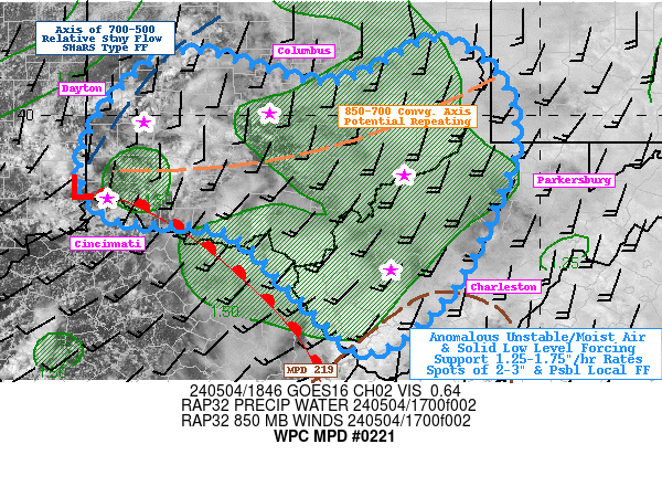
Mesoscale Precipitation Discussion 0221
NWS Weather Prediction Center College Park MD
458 PM EDT Fri May 21 2021
Areas affected...southeastern Texas and southern Louisiana
Concerning...Heavy rainfall...Flash flooding possible
Valid 212057Z - 220257Z
Summary...A conditional flash-flood threat will continue through
at least 03Z across the discussion area.
Discussion...Deep southeasterly flow along the southwestern
periphery of a mid/upper ridge centered over Kentucky continues to
help maintain a very moist airmass (characterized by PW values
near or above 2 inches) across portions of Louisiana and east
Texas. Additionally, modest instability indicated in observations
and point forecast soundings continues to combine with subtle
low-level confluence across the discussion area to produce areas
of showers and a couple thunderstorms. Furthermore, a tropical
low located roughly 180 mi east-northeast of Brownsville continues
to make steady northwestward progress toward coastal areas even
though convection remains scattered at best around the center and
along the northeastern periphery of the circulation - likely due
to dry air aloft.
The combination of the aforementioned features will continue to
foster potential for areas of scattered, yet efficient convection
with rainfall rates of 1-2 inches per hour beneath heavier cores.
Meanwhile, 10+ inches of precipitation has fallen in much of the
discussion area over the last week, leading to lowered flash flood
guidance especially along the Texas/Louisiana border region
(around 2-3 inches per 3 hours). A conditional threat for flash
flooding will exist through 03Z, but will ultimately depend on the
extent of any convective bands that can 1) organize either within
the discussion area or 2) can migrate inland from offshore areas.
Observations and CAMs hint at this potential, but pinpointing
specific areas of heightened flash flood risk remains a bit
uncertain at this time.
ATTN...WFO...HGX...LCH...LIX...SHV...
ATTN...RFC...LMRFC...WGRFC...NWC...
-
Stratton20
- Posts: 5688
- Joined: Tue Feb 09, 2021 11:35 pm
- Location: College Station, Texas
- Contact:
Thats awesome I live In katy, didnt know he was from katy but haha yep that evacuate or chill joke never gets old for my 

-
jasons2k
- Posts: 6131
- Joined: Thu Feb 04, 2010 12:54 pm
- Location: Imperial Oaks
- Contact:
Latest from Jeff, hot off the press:
There has been little change today with the organization of the area of low pressure over the NW Gulf of Mexico.
Since this morning surface observations and satellite images indicate that a surface low pressure system has formed with the disturbance over the NW Gulf of Mexico. While surface low pressure has formed, deep convection is lacking across the system and certainly near the center with a plume of dry air helping to minimize deep convection. There are some banding features to the east and southeast of the center and an area of showers and thunderstorms to the west and well to the north stretching into SE TX.
The system is moving toward the NW and this motion is expected to continue as the system is being steered by high pressure over the SE US. On this track 91L will make landfall along the middle TX coast near Matagorda Bay early Saturday morning. The system will continue to track NW and then NNW well inland over TX on Saturday. This is a high confidence forecast track. While the overall organization of the system remains poor, it would only take a brief burst of deep convection near/over the center to likely result in tropical storm formation. This will be possible as the system nears the coast later tonight, but any sustained intensification is unlikely, and even if the system becomes a weak tropical storm, the impacts will be the same as if it were to remain in its current state.
Impacts:
Main the impacts continue to be rainfall with amounts of 1-3 inches and a few higher isolated totals. Overall, the dry air wrapping into the system and the overall lack of organization should keep rainfall totals in the manageable range. With that said, much of the area will fall on the east side of the center track and we will have to be watchful for any sort of sustained bands that may attempt to setup and train for a period of time which would locally increase the rainfall totals. Creeks and bayous should be able to handle the forecasted rainfall.
Tides are elevated and will remain elevated into the weekend with water levels near 3-4 feet above (MLLW). At times of high tide, minor coastal flooding will be possible along the Gulf beaches and in the inland bays, but significant coastal flooding is not expected.
Some gusty winds of 25-35mph may occur near the center tonight along the Gulf beaches, but not expecting any significant wind concerns.
-
Stratton20
- Posts: 5688
- Joined: Tue Feb 09, 2021 11:35 pm
- Location: College Station, Texas
- Contact:
How is this not already a depression yet? It definitely has the features to be one
-
Texaspirate11

- Posts: 1278
- Joined: Tue Dec 31, 2013 12:24 am
- Contact:
Dry airStratton20 wrote: ↑Fri May 21, 2021 4:54 pm How is this not already a depression yet? It definitely has the features to be one
Cool water
Disorganized
Just because you're disabled, you don't have to be a victim
Be Weather Aware & Prepared!
Barbara Jordan Winner in Media
Disability Integration Consultant
Be Weather Aware & Prepared!
Barbara Jordan Winner in Media
Disability Integration Consultant
-
Stratton20
- Posts: 5688
- Joined: Tue Feb 09, 2021 11:35 pm
- Location: College Station, Texas
- Contact:
Texaspirate11 it has sustained winds of 35 mph which would classify it as a depression, but we will see
-
unome
- Posts: 3062
- Joined: Fri Feb 12, 2010 6:11 pm
https://www.nhc.noaa.gov/marine/forecas ... ed_gom.php
GMZ001-220830-
Synopsis for the Gulf of Mexico
425 PM EDT Fri May 21 2021
.SYNOPSIS...A low pressure is over the NW Gulf near 26.4N and
94.2W moving NW at 9 kt. The associated shower and thunderstorm
activity remains limited, but any increase in this activity may
result in the formation of a short-lived tropical depression or
storm before the system moves inland over the northwestern Gulf
coast tonight. A strong ridge stretching from the eastern seaboard
to the NE Gulf will continue to dominate the Gulf waters this
weekend. The pressure gradient will support fresh to strong E to
SE winds and high seas across the Gulf region through late Sat.
Seas will peak at around 10 to 11 ft in the north-central Gulf
through Sat morning.
-
Stratton20
- Posts: 5688
- Joined: Tue Feb 09, 2021 11:35 pm
- Location: College Station, Texas
- Contact:
Well this system is looking pretty unlikely to develop now and I can say that I am extremely disappointed that it didnt, now before anyone attacks me here let me explain, yes im happy that the rainfall amounts will be greatly reduced as some areas definitely dont need anymore, but on the flipside im disappointed because ive always been fascinated with tropical systems and hurricanes, its always interesting tracking these developing systems, its going to be a very busy season especially for the gulf of mexico
-
Rip76

- Posts: 2104
- Joined: Mon Feb 15, 2010 12:38 am
- Location: The Woodlands
- Contact:
Getting a few good rounds of showers here in Friendswood.
-
djmike

- Posts: 1856
- Joined: Fri Jan 07, 2011 12:19 pm
- Location: BEAUMONT, TX
- Contact:
I wouldn't use up a name on this storm. If thats what you wanna call it. Very disorganized. 30-35mph winds. A lonely shower or two circling this thing and arrival coming in so quick tonight. Yeah I wouldn't even bother naming this. This will all be forgotten about by this time next week. Next...
Mike
Beaumont, TX
(IH-10 & College Street)
Beaumont, TX
(IH-10 & College Street)
-
Stratton20
- Posts: 5688
- Joined: Tue Feb 09, 2021 11:35 pm
- Location: College Station, Texas
- Contact:
We got lucky Ill say that, if this system came into the gulf lets say around july or august, we would be in serious trouble, give it another month or so and the Northern Gulf should have warmers sea temps
-
Cromagnum
- Posts: 3050
- Joined: Thu Feb 03, 2011 10:42 pm
- Location: Georgetown
- Contact:
Amen on this. Don't need another Ismelda.Stratton20 wrote: ↑Fri May 21, 2021 8:05 pm We got lucky Ill say that, if this system came into the gulf lets say around july or august, we would be in serious trouble, give it another month or so and the Northern Gulf should have warmers sea temps
-
DoctorMu

- Posts: 7747
- Joined: Sun Jun 28, 2015 11:58 am
- Location: College Station
- Contact:
Some support upstairs, but dry air infiltration and the surface could restrict the system down to Minute Maid lemonade. However, recent images have some nighttime action. As long as the system doesn't linger.
https://www.star.nesdis.noaa.gov/GOES/s ... &length=24
https://www.star.nesdis.noaa.gov/GOES/s ... &length=24
https://www.star.nesdis.noaa.gov/GOES/s ... &length=24
https://www.star.nesdis.noaa.gov/GOES/s ... &length=24
Last edited by DoctorMu on Fri May 21, 2021 11:24 pm, edited 1 time in total.
-
Stratton20
- Posts: 5688
- Joined: Tue Feb 09, 2021 11:35 pm
- Location: College Station, Texas
- Contact:
DoctorMu its over for this system, no chance it develops now
-
DoctorMu
- Posts: 7747
- Joined: Sun Jun 28, 2015 11:58 am
- Location: College Station
- Contact:
Hence, lemonade.Stratton20 wrote: ↑Fri May 21, 2021 10:48 pm DoctorMu its over for this system, no chance it develops now
-
jasons2k
- Posts: 6131
- Joined: Thu Feb 04, 2010 12:54 pm
- Location: Imperial Oaks
- Contact:
There is a lot of dry air and like I said earlier this won’t amount to much. But again - some spots may see a lot of rain from feeder bands. Keep an eye out.
- Attachments
-