June 2021:
-
Stratton20
- Posts: 5686
- Joined: Tue Feb 09, 2021 11:35 pm
- Location: College Station, Texas
- Contact:
Not surprised they have a high risk, even the NHC increased the odds of formation during the the 8 pm update
- DoctorMu
- Posts: 7745
- Joined: Sun Jun 28, 2015 11:58 am
- Location: College Station
- Contact:
Our friend Brooks Garner, now in Orlando, has development in the western Carrib. at the NWS 30% level - rising from the gyre.
Brooks Garner, TV Meteorologist
i1tSposnscorehd ·
TROPICS: 6/7/21 8pm - A disturbance in the extreme southwest Caribbean Sea now has an increased 30% chance of developing into a tropical system over the next 5-days. It's still way too soon to speculate what form it may take or where it goes, but stay with #FOX35 for the latest!
-
Stratton20
- Posts: 5686
- Joined: Tue Feb 09, 2021 11:35 pm
- Location: College Station, Texas
- Contact:
Love Brooks Garner, one of my favorite meteorologists when he was at KHOU
- jasons2k
- Posts: 6127
- Joined: Thu Feb 04, 2010 12:54 pm
- Location: Imperial Oaks
- Contact:
I didn’t realize Brooks was in Orlando. Seems like yesterday he was in Denver. He must like the tropical weather (like me). Orlando is a great place except for the traffic now. I remember when driving I-4 from Tampa to Orlando was easy-breezy and mostly country (cypress trees with some Orange Groves) along the way. Now, it’s a concrete parking lot the whole trip.
Dave Marsh was the go-to for Orlando back then, too.
Anyway, it does look more and more like something will develop. Not surprising since it’s gonna be a busy season. The question is where (and how strong)? Too early to tell. 🌧 ⛈
⛈
But, in the meantime, we should dry-out and get the pool dug. Fingers crossed we can get started. We’re close.
Dave Marsh was the go-to for Orlando back then, too.
Anyway, it does look more and more like something will develop. Not surprising since it’s gonna be a busy season. The question is where (and how strong)? Too early to tell. 🌧
But, in the meantime, we should dry-out and get the pool dug. Fingers crossed we can get started. We’re close.
-
unome
- Posts: 3062
- Joined: Fri Feb 12, 2010 6:11 pm
cool tool for Central American Gyres, so glad he's at NHC
http://www.pppapin.com/gyre.php
the CPC will update their Global Tropics Benefits/Hazards today, it is produced once per week on Tuesday, updated once per week on Friday
https://www.cpc.ncep.noaa.gov/products/ ... /index.php
their archive can be found in pdf format here: https://www.cpc.ncep.noaa.gov/products/ ... CHIVE/PDF/
NHC currently has the EPac side of this gyre with slightly higher chance of developement in the next 5 days, that could change, as forecasts often do
https://www.nhc.noaa.gov/gtwo.php?basin=epac&fdays=5
https://www.nhc.noaa.gov/gtwo.php?basin=atlc&fdays=5
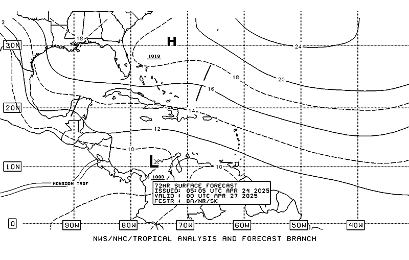
Current 72-hr Surface Forecast from NHC's section on Marine Forecasts & Analyses

http://www.pppapin.com/gyre.php
Central American Gyre Diagnostics
Based on the research conducted in Papin et al. (2017) which developed an algorithm used to identify broad circulations that possessed large wind radii and closed earth-relative winds. For more information of how to use these diagnostics see the README
the CPC will update their Global Tropics Benefits/Hazards today, it is produced once per week on Tuesday, updated once per week on Friday
https://www.cpc.ncep.noaa.gov/products/ ... /index.php
their archive can be found in pdf format here: https://www.cpc.ncep.noaa.gov/products/ ... CHIVE/PDF/
NHC currently has the EPac side of this gyre with slightly higher chance of developement in the next 5 days, that could change, as forecasts often do
https://www.nhc.noaa.gov/gtwo.php?basin=epac&fdays=5
https://www.nhc.noaa.gov/gtwo.php?basin=atlc&fdays=5
Current 72-hr Surface Forecast from NHC's section on Marine Forecasts & Analyses

- don
- Posts: 3129
- Joined: Wed Feb 03, 2010 3:33 pm
- Location: Wichita Falls
- Contact:
One thing to keep in mind is that there's a chance the gyre will only form a storm on the Pacific side. There's also a chance that we either get a crossover. Or development of two storms,one in the Pacific and one in the Atlantic. These gyres can be a forecast nightmare. As they are very hard to pin down.Due to multiple vortocities in the gyre competing with each other for energy.
-
Scott747
- Posts: 1647
- Joined: Tue Feb 23, 2010 9:56 am
- Location: Freeport/Surfside Beach
- Contact:
The 0z Euro dropped potential mischief in the BoC last night but the 12z GFS and Canadian continue with the idea of something, though it continues to be pushed back in the long range. Not surprising with these type of gyre setups as the models have issues resolving the eventual genesis.
-
Stratton20
- Posts: 5686
- Joined: Tue Feb 09, 2021 11:35 pm
- Location: College Station, Texas
- Contact:
At this point The Euro has Notorious a history of flip flopping, Im not paying much attention to the operational models as it still has ensemble support, operational mode runs are only good out to 5 days, we also saw last year how multiple disturbances developed and models didnt pick up on them till they became a depression, wouldnt be shocked if the 12z Euro shows something again, looks like another forecasting headache is in the books this week haha
-
txbear
- Posts: 249
- Joined: Wed Oct 31, 2018 12:54 pm
- Contact:
Can always tell when it's that time of year seeing you on the board, Scott. Thanks for taking time to chime in here, it's always helpful and insightful.Scott747 wrote: ↑Tue Jun 08, 2021 12:12 pm The 0z Euro dropped potential mischief in the BoC last night but the 12z GFS and Canadian continue with the idea of something, though it continues to be pushed back in the long range. Not surprising with these type of gyre setups as the models have issues resolving the eventual genesis.
-
Cpv17
- Posts: 6926
- Joined: Fri Aug 31, 2018 1:58 pm
- Location: El Campo/Wharton
- Contact:
Yes the 0z Euro operational dropped it but it still has EPS support. Till that’s gone imo then the Euro didn’t drop it, just the op did.
-
Stratton20
- Posts: 5686
- Joined: Tue Feb 09, 2021 11:35 pm
- Location: College Station, Texas
- Contact:
CP17 exactly! As long as their is still a decent amount of ensemble support from the Euro members, 1 operational run doesnt mean much of anything
-
Scott747
- Posts: 1647
- Joined: Tue Feb 23, 2010 9:56 am
- Location: Freeport/Surfside Beach
- Contact:
Thanks for the kind words. I made a brief appearance for the bitter cold blast but quickly went back into hibernation. lol.txbear wrote: ↑Tue Jun 08, 2021 12:34 pmCan always tell when it's that time of year seeing you on the board, Scott. Thanks for taking time to chime in here, it's always helpful and insightful.Scott747 wrote: ↑Tue Jun 08, 2021 12:12 pm The 0z Euro dropped potential mischief in the BoC last night but the 12z GFS and Canadian continue with the idea of something, though it continues to be pushed back in the long range. Not surprising with these type of gyre setups as the models have issues resolving the eventual genesis.
12z hi-res Euro is back onboard with a decent system in the BoC. Still long range but hard to ignore with this much operational support.
- don
- Posts: 3129
- Joined: Wed Feb 03, 2010 3:33 pm
- Location: Wichita Falls
- Contact:
12z EURO is very aggressive with tropical genesis in the BOC,for June at least, but still a ways out...
-
Stratton20
- Posts: 5686
- Joined: Tue Feb 09, 2021 11:35 pm
- Location: College Station, Texas
- Contact:
Yep saw that,it has the Disturbance getting into the gulf by this sunday and it develops it into a Cat 1 hurricane and heads North Towards Texas... Thats very interesting as quite a few ensemble members have a similar solution, interesting to note that the Euro has this disturbance in the gulf by Sunday, only 4- 5 days from now, thats sooner than the other models are, definitely a trend to watch
-
Stormlover2020
- Posts: 562
- Joined: Mon Jun 01, 2020 6:04 pm
- Contact:
- don
- Posts: 3129
- Joined: Wed Feb 03, 2010 3:33 pm
- Location: Wichita Falls
- Contact:
- DoctorMu
- Posts: 7745
- Joined: Sun Jun 28, 2015 11:58 am
- Location: College Station
- Contact:
Very warm in the BoC. I'd expect some lemonade brewing within a week and drifting through the western GoM. Hopefully, nothing too organized. We'll see.
https://youtu.be/hftgytmgQgE
-
Stratton20
- Posts: 5686
- Joined: Tue Feb 09, 2021 11:35 pm
- Location: College Station, Texas
- Contact:
Evem though models very on location and timing, their does seem to be a consensus in this being a western gulf of mexico storm threat
-
Pas_Bon
- Posts: 923
- Joined: Tue Sep 11, 2018 7:58 am
- Location: League City, TX
- Contact:
I think it's time to start counting this as a likely scenario in the BOC. When and where is completely up in the air, but my suspicions are that we will be tracking a system somewhat soon.....
-
Stratton20
- Posts: 5686
- Joined: Tue Feb 09, 2021 11:35 pm
- Location: College Station, Texas
- Contact:
Pas_Bon I have to agree with you here, water temps in the BOC are in the 85-88 degree range, definitely very very conducive for development