
July 2025
-
869MB
- Posts: 203
- Joined: Fri Oct 30, 2015 8:44 am
- Location: Katy, TX
- Contact:
Besides maybe the CMC at times, the long range global models have been close to useless for all intents and purposes. Last week all of the models, outside of the CMC like I illustrated yesterday, depicted a hot and dry weather pattern over the majority of Central and SE TX this week through July 4th. I distinctly remember David Tillman suggesting last week we may not see any rain for 10 days straight or longer, yet here we are.
-
user:null
- Posts: 465
- Joined: Fri Jul 01, 2022 7:04 pm
- Location: The Land of Sugar
- Contact:
I very much think that models have a "dry bias" over Texas during summer. Even the recent NWS discussion (morning) made note of this.869MB wrote: ↑Sat Jul 05, 2025 3:48 pm Besides maybe the CMC at times, the long range global models have been close to useless for all intents and purposes. Last week all of the models, outside of the CMC like I illustrated yesterday, depicted a hot and dry weather pattern over the majority of Central and SE TX this week through July 4th. I distinctly remember David Tillman suggesting last week we may not see any rain for 10 days straight or longer, yet here we are.
-
Ptarmigan

- Statistical Specialist

- Posts: 4431
- Joined: Wed Feb 03, 2010 7:20 pm
- Contact:
-
Cromagnum
- Posts: 3021
- Joined: Thu Feb 03, 2011 10:42 pm
- Location: Georgetown
- Contact:
I just can't anymore with social media. I'm pretty well convinced the average person is functionally brain damaged with some of the BS I've seen spewed online.
-
DoctorMu

- Posts: 7622
- Joined: Sun Jun 28, 2015 11:58 am
- Location: College Station
- Contact:
Understaffing a NWS (Houston down 44%) and reduced weather ballon launchings are impacting modeling.
The Euro may be less affected. TWC picked up on increased rain chances and amount of rain than NWS, models, mesos. The cuts are costing more in dollars and lives than any savings.
The Euro may be less affected. TWC picked up on increased rain chances and amount of rain than NWS, models, mesos. The cuts are costing more in dollars and lives than any savings.
-
DoctorMu
- Posts: 7622
- Joined: Sun Jun 28, 2015 11:58 am
- Location: College Station
- Contact:
Should mention that occurrence around the holidays doesn’t help in staffing and accuracy.
-
tireman4

- Global Moderator

- Posts: 6747
- Joined: Wed Feb 03, 2010 9:24 pm
- Location: Humble, Texas
- Contact:
Steve McCauley
- Attachments
-
- FB_IMG_1751803813152.jpg (129.14 KiB) Viewed 1900 times
-
DoctorMu
- Posts: 7622
- Joined: Sun Jun 28, 2015 11:58 am
- Location: College Station
- Contact:
Clouds and rain are still around CLL, despite a 10% chance of rain forecast and forecast by HGX yesterday that the low would be gone. Lots of rain in the Hill Country NW of Waco, including Granbury.
This warm core low has not given up the ghost yet. To be fair, post, ghostly tropical systems and moisture as we know maintain energy that causes damage many after landfall. The NC mountains found that out first hand with Helene...although NWS forecasts were of great concern.
Keep in mind that Beryl's forecast and damage really snuck up on some of the forecasters and people around the July 4 holiday last year, including in Texas. Skeleton MSM and weather crews missed it.
TWC has been broadcasting programs about lobster fisherman and ice truckers instead of the deadly flooding weather in the Hill Country.
https://www.star.nesdis.noaa.gov/goes/s ... &length=24
-
DoctorMu
- Posts: 7622
- Joined: Sun Jun 28, 2015 11:58 am
- Location: College Station
- Contact:
This was the NWS forecast discussion Thursday night when campers and counselors in Kerr County were preparing to sleep.
Tricky, but was it actionable? Kerr County was not included in the flood watch. How many counselors would have had weather alert from NOAA or local forecasts on their smart phones. Were some out of cell range? Tragic circumstances. The clues for disaster are there in the forecast discussion.
UPDATE...
Issued at 855 PM CDT Thu Jul 3 2025
Updated the Flood Watch to include Bexar, Kendall, Gillespie, and
Llano Counties. The Flood Watch is in effect through 7 AM Friday.
Abundant tropical moisture continues to be pulled across the local
area this evening and stays through the overnight hours. A low level
jet is forecast to increase through the period and helps with the
development of new cells which are expected to be heavy rain
producers with precipitable water values ranging from 2 to 2.5
inches. Rainfall amounts of 1 to 3 inches with isolated 5 to 7 inches
are possible across the Flood Watch area.
&&
.SHORT TERM...
(Tonight through Friday night)
Issued at 138 PM CDT Thu Jul 3 2025
Scattered shower activity has been ongoing across South-Central
Texas throughout the late morning and early afternoon, with a
gradual increase in coverage. A substantial plume of deep tropical
moisture continues to stream north across South-Central Texas,
characterized by unseasonably moist precipitable water values as
high as about 2.4 inches. The 12Z Del Rio upper-air sounding this
morning observed a PW of 2.31 inches, which is near daily record
high values. The axis of a negatively tilted mid-level trough most
readily apparent on 700mb analyses is beginning to move poleward
towards the Edwards Plateau, leading to rounds of shower activity
throughout South-Central Texas into tomorrow as the advancing trough
prompts the ascent of moist air. A mesoscale convective vortex over
the Big Bend area has also enhanced moisture advection into our
region.
Observed and simulated vertical profiles show an environment
presently conducive to heavy rain, supporting 1 to 2 inch per hour
rain rates. Given the broad region of rising air and lack of
dominant surface boundaries, shower activity looks to remain widely
distributed across South-Central Texas with sufficient instability
for isolated to widely scattered thunderstorms. Strong gusts of 40
to 50 mph are also possible as the heavy rain rates drag down cooler
air aloft. Cold pools expanding under weak deep-layer flow may
become a focusing mechanism for concentrating a few clusters of
showers and storms as depicted on some of the high-resolution
mesoscale guidance, and the heaviest rain totals may be associated
with these slow-moving clusters. Models remain in disagreement over
the placement of the heaviest rain totals, though the greatest
rainfall potential this afternoon into tonight is over the Highway
90 corridor, southern Edwards Plateau and Hill Country. Rainfall
totals of 1 to 3 inches appear likely, but locally higher amounts
upwards of 5 to 7 inches could materialize if slow-moving storms
begin to cluster. Given the heavy rainfall potential, some flooding
is possible. A Flood Watch is now in effect through 7 AM Friday
morning for the southern Edwards Plateau and western Hill Country,
where the intersection of higher forecast rainfall amounts and
rainfall from the past few days is most evident. While the greatest
concentration of modeled precipitation is in the aforementioned
areas, the highest rain amounts could shift depending on where
storms aggregate, and expansion towards the I-35 corridor is
possible later this evening into the overnight as the trough moves
gradually east.
Coverage of showers and storms should begin to decrease Friday as
the axis of the trough swings out of our area. However, the
environment continues to support isolated showers favoring mostly
the southern Edwards Plateau and Hill Country as the moist tropical
airmass remains in place. Additional shower development could also
occur along convergent flow through the Coastal Plains towards the I-
35 corridor. Cloud cover and rain-cooled air will support
temperatures near to below average for this time of year. Highs in
the 80s to low 90s are expected with lows in the mid 70s.
&&
-
Cpv17
- Posts: 6817
- Joined: Fri Aug 31, 2018 1:58 pm
- Location: El Campo/Wharton
- Contact:
It’s truly sickening. There couldn’t have been a worse time for this to happen.DoctorMu wrote: ↑Sun Jul 06, 2025 12:33 pm This was the NWS forecast discussion Thursday night when campers and counselors in Kerr County were preparing to sleep.
Tricky, but was it actionable? Kerr County was not included in the flood watch. How many counselors would have had weather alert from NOAA or local forecasts on their smart phones. Were some out of cell range? Tragic circumstances. The clues for disaster are there in the forecast discussion.
UPDATE...
Issued at 855 PM CDT Thu Jul 3 2025
Updated the Flood Watch to include Bexar, Kendall, Gillespie, and
Llano Counties. The Flood Watch is in effect through 7 AM Friday.
Abundant tropical moisture continues to be pulled across the local
area this evening and stays through the overnight hours. A low level
jet is forecast to increase through the period and helps with the
development of new cells which are expected to be heavy rain
producers with precipitable water values ranging from 2 to 2.5
inches. Rainfall amounts of 1 to 3 inches with isolated 5 to 7 inches
are possible across the Flood Watch area.
&&
.SHORT TERM...
(Tonight through Friday night)
Issued at 138 PM CDT Thu Jul 3 2025
Scattered shower activity has been ongoing across South-Central
Texas throughout the late morning and early afternoon, with a
gradual increase in coverage. A substantial plume of deep tropical
moisture continues to stream north across South-Central Texas,
characterized by unseasonably moist precipitable water values as
high as about 2.4 inches. The 12Z Del Rio upper-air sounding this
morning observed a PW of 2.31 inches, which is near daily record
high values. The axis of a negatively tilted mid-level trough most
readily apparent on 700mb analyses is beginning to move poleward
towards the Edwards Plateau, leading to rounds of shower activity
throughout South-Central Texas into tomorrow as the advancing trough
prompts the ascent of moist air. A mesoscale convective vortex over
the Big Bend area has also enhanced moisture advection into our
region.
Observed and simulated vertical profiles show an environment
presently conducive to heavy rain, supporting 1 to 2 inch per hour
rain rates. Given the broad region of rising air and lack of
dominant surface boundaries, shower activity looks to remain widely
distributed across South-Central Texas with sufficient instability
for isolated to widely scattered thunderstorms. Strong gusts of 40
to 50 mph are also possible as the heavy rain rates drag down cooler
air aloft. Cold pools expanding under weak deep-layer flow may
become a focusing mechanism for concentrating a few clusters of
showers and storms as depicted on some of the high-resolution
mesoscale guidance, and the heaviest rain totals may be associated
with these slow-moving clusters. Models remain in disagreement over
the placement of the heaviest rain totals, though the greatest
rainfall potential this afternoon into tonight is over the Highway
90 corridor, southern Edwards Plateau and Hill Country. Rainfall
totals of 1 to 3 inches appear likely, but locally higher amounts
upwards of 5 to 7 inches could materialize if slow-moving storms
begin to cluster. Given the heavy rainfall potential, some flooding
is possible. A Flood Watch is now in effect through 7 AM Friday
morning for the southern Edwards Plateau and western Hill Country,
where the intersection of higher forecast rainfall amounts and
rainfall from the past few days is most evident. While the greatest
concentration of modeled precipitation is in the aforementioned
areas, the highest rain amounts could shift depending on where
storms aggregate, and expansion towards the I-35 corridor is
possible later this evening into the overnight as the trough moves
gradually east.
Coverage of showers and storms should begin to decrease Friday as
the axis of the trough swings out of our area. However, the
environment continues to support isolated showers favoring mostly
the southern Edwards Plateau and Hill Country as the moist tropical
airmass remains in place. Additional shower development could also
occur along convergent flow through the Coastal Plains towards the I-
35 corridor. Cloud cover and rain-cooled air will support
temperatures near to below average for this time of year. Highs in
the 80s to low 90s are expected with lows in the mid 70s.
&&
-
DoctorMu
- Posts: 7622
- Joined: Sun Jun 28, 2015 11:58 am
- Location: College Station
- Contact:
^I think Kerr Co. was likely in the original flood watch, but not mentioned in that update. Smart phones should have weather updates. I have to keep in mind that unless someone is a weather geek like us, there are too many nuances and background for the general public to comprehend the potential danger. A 26 ft surge - a tidal wave with trees, logs, debris, rocks
And during a camping/holiday/down weekend.
And during a camping/holiday/down weekend.
-
Rip76

- Posts: 2083
- Joined: Mon Feb 15, 2010 12:38 am
- Location: The Woodlands
- Contact:
DoctorMu wrote: ↑Sun Jul 06, 2025 12:16 pm Clouds and rain are still around CLL, despite a 10% chance of rain forecast and forecast by HGX yesterday that the low would be gone. Lots of rain in the Hill Country NW of Waco, including Granbury.
This warm core low has not given up the ghost yet. To be fair, post, ghostly tropical systems and moisture as we know maintain energy that causes damage many after landfall. The NC mountains found that out first hand with Helene...although NWS forecasts were of great concern.
Keep in mind that Beryl's forecast and damage really snuck up on some of the forecasters and people around the July 4 holiday last year, including in Texas. Skeleton MSM and weather crews missed it.
TWC has been broadcasting programs about lobster fisherman and ice truckers instead of the deadly flooding weather in the Hill Country.
https://www.star.nesdis.noaa.gov/goes/s ... &length=24
CNN is running flood news non-stop.
-
Rip76
- Posts: 2083
- Joined: Mon Feb 15, 2010 12:38 am
- Location: The Woodlands
- Contact:
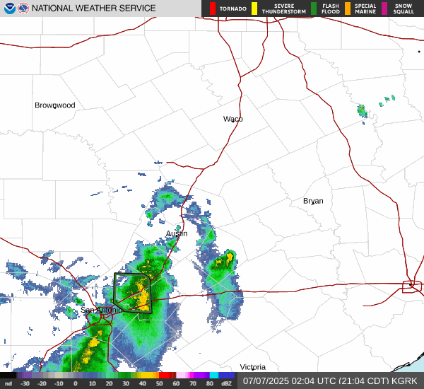
Texas radar starting to light up.
-
Stratton20
- Posts: 5612
- Joined: Tue Feb 09, 2021 11:35 pm
- Location: College Station, Texas
- Contact:
Unfortunately storms are agaib forming in the absolute worst areas possible, kerrville might get hit hard again, this wet pattern can truely piss off for central texas, just absolutely gut wrenching to think more rain could fall in some of the hardest hit areas
-
DoctorMu
- Posts: 7622
- Joined: Sun Jun 28, 2015 11:58 am
- Location: College Station
- Contact:
Now, they are - CNN follows shiny objects.Rip76 wrote: ↑Sun Jul 06, 2025 1:54 pmDoctorMu wrote: ↑Sun Jul 06, 2025 12:16 pm Clouds and rain are still around CLL, despite a 10% chance of rain forecast and forecast by HGX yesterday that the low would be gone. Lots of rain in the Hill Country NW of Waco, including Granbury.
This warm core low has not given up the ghost yet. To be fair, post, ghostly tropical systems and moisture as we know maintain energy that causes damage many after landfall. The NC mountains found that out first hand with Helene...although NWS forecasts were of great concern.
Keep in mind that Beryl's forecast and damage really snuck up on some of the forecasters and people around the July 4 holiday last year, including in Texas. Skeleton MSM and weather crews missed it.
TWC has been broadcasting programs about lobster fisherman and ice truckers instead of the deadly flooding weather in the Hill Country.
https://www.star.nesdis.noaa.gov/goes/s ... &length=24
CNN is running flood news non-stop.
-
DoctorMu
- Posts: 7622
- Joined: Sun Jun 28, 2015 11:58 am
- Location: College Station
- Contact:
-
Rip76
- Posts: 2083
- Joined: Mon Feb 15, 2010 12:38 am
- Location: The Woodlands
- Contact:
Lindner 5pm
Heavy rainfall and flash flooding has redeveloped over portions of north Texas and recently over the Guadelupe River
Additional heavy rainfall and flash flooding is possible tonight over the TX Hill Country
Persons across central TX and the Hill Country need to remain informed on weather conditions that can change rapidly.
Guadelupe River:
Heavy rainfall has occurred in the last hour upstream of Kerrville in the Ingram and Hunt areas. Rainfall amounts of 1-3 inches have been recorded and this is expected to result in a rise in the Guadelupe River to above flood stage in the next hour or so with peak near 12 ft around Hunt, TX. At these level slow water crossings are flooded and impassable with fast flowing water and flow reaches the bottom of the HWY 39 bridge crossing. Areas upstream of Hunt may become cut-off on both the south and north Forks of the Guadelupe River.
Ongoing search and rescue operations have been suspended in this area due to the threat of flash flooding and any persons near the river need to seek higher ground.
Note: TFR is in place for Kerr County due to private drone interference with rescue operations along with other SAR activities.
Note: Traffic congestion in this region is extremely heavy due to search and rescue efforts and influx of various support teams. Those not needing to be in this area should refrain from travel to the impacted areas.
NC TX:
Heavy rainfall focused this morning and early afternoon northwest of Waco and southwest of Fort Worth with several areas of ongoing flash flooding. Rainfall in this area has weakened and is shifting southward into a more unstable air mass over the I-35 corridor into the TX Hill Country.
Forecast:
Guidance generally shows activity weakening this evening into the overnight hours only to redevelop over the I-35 corridor and Hill Country on Monday.
As we have been dealing with the last several days…isolated instances of extreme rainfall will be possible with very high hourly rainfall rates which will lead to rapid flash flooding of normally dry creeks and rivers. The locations and amounts of any significant rainfall amounts remain in flux, but the general air mass remains capable of some significant totals. Persons must remain aware of changing weather conditions in this area into Monday.
The current statewide death toll has risen to 70 which has surpassed Harvey’s 68. While data is still be looked at and collect and numbers are fluid, this is one of the most fatalities from a flash flood event in the state of Texas in modern times.
Kerr County: 59
Travis County: 5
Burnet County: 3
Williamson County: 2
Tom Green County: 1
These numbers were as of 245pm today.
Jeff Lindner
Director Hydrologic Operations Division/Meteorologist
Harris County Flood Control District
-
DoctorMu
- Posts: 7622
- Joined: Sun Jun 28, 2015 11:58 am
- Location: College Station
- Contact:
CLL NWS forecast has tilted towards the Euro solution. Good choice.
-
Pas_Bon
- Posts: 921
- Joined: Tue Sep 11, 2018 7:58 am
- Location: League City, TX
- Contact:
This event has devastated me on a level which I cannot remember feeling since Katrina. I was stuck at a NOLA hospital during Katrina and afterwards. This caused all those memories to come flooding back. I know Harvey was horrible, too. I picked up my 11yo daughter from week-long Summer camp on Saturday morning and there are parents who never had the chance to do so. I am gutted.
-
tireman4
- Global Moderator
- Posts: 6747
- Joined: Wed Feb 03, 2010 9:24 pm
- Location: Humble, Texas
- Contact:
Jeff Lindner ( When you read this, both amateur and pro mets alike, you just gasp)
- Attachments
-
- Screenshot 2025-07-07 081823.jpg (159.93 KiB) Viewed 1486 times